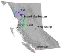
Sacred Headwaters

Last updated
Sacred Headwaters
Klabona (Tahltan)
Sacredheadwaters.jpg
Sacred Headwaters
Sacredheadwatersmap.jpg
Location in British Columbia
Coordinates: 57°13′00″N129°01′00″W / 57.21667°N 129.01667°W / 57.21667; -129.01667
Location Kitimat-Stikine RD and Stikine Region, British Columbia
Native nameKlabona (Tahltan)

The Sacred Headwaters is a large subalpine drainage basin centred around Klappan Mountain of the Klappan Range in northern British Columbia. It is the source of three wild salmon rivers: the Skeena River, Nass River, and Stikine River. It is also referred to as the Klappan Valley, although the Klappan—a tributary of the Stikine River—is only one of the area's watersheds. Local Tahltan people call the area Klabona, which is loosely translated as "headwaters".

Contents

Ecology

The area has a significant population of grizzly bears, stone sheep, caribou, wolves, and mountain goats. [1] Salmon swim over 400 kilometres from the Pacific Ocean to spawn in the upper reaches of the river.[ citation needed ]

Industrial development

The Sacred Headwaters is rich in mineral and energy resources, particularly coal and coalbed methane. Several industrial development projects were planned for the area, including Fortune Minerals' open-pit Klappan Coal Mine [2] and Royal Dutch Shell's Klappan Coalbed Methane Project. [3] Shell Canada in 2009 conducted several environmental baseline studies within the Klappan tenure area. [4] The British Columbia Ministry of Energy, Mines and Petroleum Resources estimates the Klappan coal deposit could contain as much as 8.1 trillion cubic feet (230 km3) of coalbed methane gas. [5]

Klappan Coal Mine

Fortune Coal Limited (FCL) entered on 13 July 2011 into an unincorporated joint venture with Posco Canada (POSCAN). The venture, an 80–20 split, was based on mineral rights held by FCL and finances provided by POSCAN. FCL was 100% controlled by Fortune Minerals Limited, an Ontario-based company that traded on the TSX Venture Exchange. POSCAN, which contributed $30 million to the project, was a subsidiary of one of the world's largest steel producers, [6] and had strong ties to the Government of South Korea. [7] The financial resources of the FML were not sufficient to bring any of its properties into commercial production as of 2012. The Klappan project was estimated to need $789 million to begin production, and to generate substantially less than 1,000 jobs. [8] FML called this the "Arctos Anthracite Project". [6]

The government of British Columbia, in whose jurisdiction the mineral rights are held, planned on 20 September 2013 to dispatch a minister to deal with the First Nations' blockade of the project. [9] Some First Nations groups committed to defending the Sacred Headwaters. "We dare Fortune to get us arrested," said group spokesperson Rhoda Quock. “We have cameras here. We will make sure the world knows what’s going on.” [10] On 23 September Quock was interviewed [11] on CBC's As It Happens , and asked Fortune to obtain an injunction. The CEO of FML said on 24 September that the company would not seek an injunction, and that they would let the BC government mediate a settlement instead. [12]

Klappan Coalbed Methane Project

The Klappan Coalbed Methane Project was a proposal by Shell Canada to develop a coalbed methane project in the Sacred Headwaters. In 2004, the British Columbia government granted Royal Dutch Shell a 400,000-hectare (4,000 km2) tenure for coalbed methane development. It was accessed by road via the abandoned BC Rail grade, which intersects British Columbia Highway 37 south of Iskut. As of summer 2008, Shell's project was in the exploration phase. Shell drilled three exploratory wells in 2004 and was preparing to drill 14 additional wells in 2008, 8 of which were proposed for the headwaters of the Skeena River. If developed, Shell's project would have entailed a network of gas wells connected by roads and pipelines, as well as a pipeline to deliver the gas to market. Shell disclosed neither how many wells would have been necessary to make the project economically viable nor route options for the delivery pipeline. The Klappan Coalbed Methane Project was opposed by both First Nations groups and non-governmental organizations. The Pembina Institute, an environmentalist think-tank, released a report on the potential impacts of the Klappan Coalbed Methane Project on wild salmon, calling it a "risky experiment" as commercial coalbed methane production had never been attempted in a salmon-bearing watershed. [13] On December 18, 2012, the B.C. government announced that Shell Canada would relinquish its tenure on the land, and that oil and gas development would be banned in the Sacred Headwaters.

Developments since 2015

In April 2015, the Government of British Columbia bought all coal licences in the area around Mount Klappan, halting development for the foreseeable future. At the same time, the Tahltan First Nation and provincial government began working on a long-term plan for the Sacred Headwaters. [14]

The campaign to protect the Sacred Headwaters from industrial development is profiled in a 2022 documentary film, The Klabona Keepers . [15]

Related Research Articles

<span class="mw-page-title-main">Stikine River</span> River in British Columbia and Alaska

The Stikine River is a major river in northern British Columbia (BC), Canada and southeastern Alaska in the United States. It drains a large, remote upland area known as the Stikine Country east of the Coast Mountains. Flowing west and south for 610 kilometres (379 mi), it empties into various straits of the Inside Passage near Wrangell, Alaska. About 90 percent of the river's length and 95 percent of its drainage basin are in Canada. Considered one of the last truly wild large rivers in BC, the Stikine flows through a variety of landscapes including boreal forest, steep canyons and wide glacial valleys.

<span class="mw-page-title-main">Tahltan</span> First Nations people native to northern British Columbia, Canada

The Tahltan or Nahani are a First Nations people of the Athabaskan-speaking ethnolinguistic group who live in northern British Columbia around Telegraph Creek, Dease Lake, and Iskut. The Tahltan constitute the fourth division of the Nahane.

Iskut is a small, mostly Indigenous community in the Stikine Country of northwestern British Columbia. It is located on Highway 37, at the north end of Eddontenajon Lake just south of Dease Lake and the crossing of the Stikine River.

Spatsizi Headwaters Provincial Park is a provincial park in the Stikine Region of British Columbia, Canada. It was established on January 25, 2001 to protect the headwaters of the Spatsizi River while providing recreational facilities for visitors.

Spatsizi Plateau Wilderness Provincial Park is located in the northern portion of British Columbia, Canada, approximately 698, 659 hectares and encompasses the Spatsizi River and Gladys Lake Ecological Reserve. The park is a designated protected area that is intended for the conservation and research on caribou, grizzly bears, fish, and other wildlife species populations. Before the provincial park's establishment in 1975, the area was a historical hunting ground for local Indigenous communities like the Tahltan First Nations.It is the second largest provincial park in British Columbia.

<span class="mw-page-title-main">Skeena Mountains</span> Mountains in British Columbia, Canada

The Skeena Mountains, also known as the Skeenas, are a subrange of the Interior Mountains of northern British Columbia, Canada, essentially flanking the upper basin of the Skeena River. They lie just inland from the southern end of the Boundary Ranges of the Coast Mountains, and also of the northern end of the Kitimat Ranges. Their southern limit is described by the Bulkley River and the upper northwestern reaches of Babine and Takla Lakes, and on their northeast by the upper reaches of the Omineca River.

<span class="mw-page-title-main">Stikine Country</span> Geographic region of British Columbia, Canada

The Stikine Country, also referred to as the Stikine District or simply "the Stikine", is one of the historical geographic regions of the Canadian province of British Columbia, located inland from the central Alaska Panhandle and comprising the basin of the Stikine River and its tributaries. The term Stikine–Iskut is also fairly common to describe the area, and references the Iskut River, the Stikine's largest tributary and describable as its south fork.

<span class="mw-page-title-main">Stikine Plateau</span> Plateau in British Columbia, Canada

The Stikine Plateau is a plateau in northern British Columbia, Canada. It lies between the Boundary Ranges of the Coast Mountains on the west and southwest and the Cassiar Mountains along its northeast, and between the Skeena Mountains on its south and southeast and the Jennings and Nakina Rivers on the north.

The Skeena Watershed Conservation Coalition is a non-governmental organization based in British Columbia which opposes Royal Dutch Shell's Klappan Coalbed Methane Project in a region dubbed the Sacred Headwaters by the Tahltan people, which is located in a mountainous area where the Klappan, Stikine, Skeena and Nass Rivers all have their origin. It was founded in 2004 by a diverse group of people living and working in the Skeena River watershed.

The Tàłtàn Nation is a tribal council-type organization combining the governments of two band governments of the Tahltan people in the Stikine Country of the Northern Interior of British Columbia, Canada. The two member governments are the Iskut First Nation and the Tahltan First Nation, which is also known as the Tahltan Indian Band. The Tahltan Nation is governed by the Tahltan Central Council, which is composed of representatives of 10 families from each band and has its offices at Dease Lake and Telegraph Creek.

The Klappan Coalbed Methane Project is a gas project owned by Shell Canada that looks to develop the coalbed methane from an area in northern British Columbia, near the source of three rivers: the Skeena River, Nass River, and Stikine River, and also the namesake Klappan River. The area is known in environmental politics and native lore as the Sacred Headwaters or Kablona. The project is the source of controversy and is opposed by First Nations groups and non-governmental organizations. If developed, the project will include a network of gas wells connected by roads and pipelines, as well as a pipeline to deliver the gas to market.

The Klappan Range is a small subrange of the Skeena Mountains of the Interior Mountains, located between Klappan River and Iskut River in northern British Columbia, Canada.

The Klastline Plateau is a plateau in the Stikine Region of the Northern Interior of British Columbia, Canada. A subplateau of the Stikine Plateau, it is located between the Stikine River (N), the upper Iskut River (S), Mess Creek (W) and the Klappan River (E). The Skeena Mountains are to the south, the Tahltan Highland to the west, the Spatsizi Plateau to the east, and the Tanzilla Plateau to the north, on the other side of the Stikine. The Spatsizi and Tanzilla Plateaus, and the Tahltan Highland, are also part of the Stikine Plateau.

The Craig River is a transboundary river tributary of the Iskut River in Southeast Alaska, United States, and the northwest part of the province of British Columbia, Canada. Originating in Alaska, where it is sometimes called the South Fork Craig River, the Craig flows into British Columbia, generally in a northeast then northwest direction for about 50 km (31 mi) to join the Iskut River about 2 km (1.2 mi) east of the confluence of the Iskut and Hoodoo River. Its main tributary is the Jekill River.

Dogwood BC is a Canadian non-profit public interest group based in Victoria, British Columbia. The organization works to increase the power of British Columbians over government decision-making. They were instrumental in the fight against Enbridge's Northern Gateway pipeline, introducing a tanker moratorium on B.C.'s north coast and the province's campaign finance reform. The organization currently works to stop Kinder Morgan's Trans Mountain tanker and pipeline expansion in B.C., ban U.S. thermal coal exports through B.C. ports and restore accountability and transparency to the province's democracy by calling for a Corruption Inquiry.

The Tuya River is a major tributary of the Stikine River in northwest part of the province of British Columbia, Canada. From its source at High Tuya Lake in Tuya Mountains Provincial Park just south of Ash Mountain, the highest peak of the Tuya Range, the Tuya River flows south about 200 km (120 mi) to meet the Stikine River in the Grand Canyon of the Stikine. The Tuya River's main tributary is the Little Tuya River. The Tuya River divides the Tanzilla Plateau on the east from the Kawdy Plateau, to the northwest, and the Nahlin Plateau, to the southwest. All three are considered sub-plateaus of the Stikine Plateau. The Tuya River's watershed covers 3,575 km2 (1,380 sq mi), and its mean annual discharge is estimated at 36.9 m3/s (1,300 cu ft/s). The mouth of the Tuya River is located about 24 km (15 mi) northeast of Telegraph Creek, British Columbia, about 67 km (42 mi) southwest of Dease Lake, British Columbia, and about 210 km (130 mi) east of Juneau, Alaska. The Tuya River's watershed's land cover is classified as 35.7% shrubland, 31.4% conifer forest, 14.0% mixed forest, 7.2% herbaceous, and small amounts of other cover.

The Little Tuya River is a tributary of the Tuya River in northwest part of the province of British Columbia, Canada. It flows generally south and east about 71 km (44 mi) to join the Tuya River near Cariboo Meadows. The Little Tuya River's watershed covers 569 km2 (220 sq mi), and its mean annual discharge is an estimated 6.69 m3/s (236 cu ft/s).

The Klappan River is a major tributary of the Stikine River in northwestern British Columbia, Canada. It flows north from an area known as the Sacred Headwaters, which is the source not only of this river but also of the Nass, Skeena, Spatsizi and Stikine Rivers. The headwaters region is the site of a controversial coal-bed methane project.

Annita McPhee is the former three-term president of the Tahltan Nation in British Columbia, Canada. She was also named National Native Role Model by Governor-General Adrienne Clarkson in 2000 and won the Aboriginal Woman of Distinction Award.

<span class="mw-page-title-main">Bell-Irving River</span> River in British Columbia, Canada

The Bell-Irving River is a tributary of the Nass River in northwestern British Columbia, Canada. It originates in the Sacred Headwaters region, and flows about 165 km (103 mi) south to the Nass River. It course lies between the Oweegee Range of the Skeena Mountains to the east and the Boundary Ranges of the Coast Mountains to the west.

References

  1. "Fort St. James Land and Resource Management Plan". 1999. Retrieved 2009-03-27.
  2. "Klappan Coal mine".
  3. "Klappan Coalbed Methane project".
  4. "Shell Canada – Protect the Klappan Environment".
  5. A Summary of Coalbed Methane Potential in British Columbia, Barry Ryan, BC Ministry of Energy and Mines, British Columbia (no date).
  6. 1 2 "Arctos Anthracite Project" web page.
  7. " Company Overview of POSCO Canada Ltd." on Business Week
  8. Fortune Minerals 2012 Annual Information Form
  9. CBC.ca: "B.C. minister to visit First Nation blockade"
  10. Business in Vancouver 20 Sep 2013: "Tahltan Elders ramp up Sacred Headwaters mine protest after mediator appointment"
  11. CBC interview, "As It Happens" 23 Sept 2013
  12. "As it Happens" edition 24 September 2013
  13. "Coalbed Methane & Salmon" (PDF). Pembina Institute. Retrieved 2009-03-27.
  14. Ollerenshaw, N C (1977). "Canadian Government Coal Block, Parcel 73, Fernie Basin, British Columbia". doi:10.4095/102676.{{cite journal}}: Cite journal requires |journal= (help)
  15. Hannah Schmidt, "Documentary filmed in Northwest B.C. to be screened at Toronto film fest". CFTK-TV, May 17, 2022.