National parks of Canada are protected natural spaces throughout the country that represent distinct geographical regions of the nation. Under the administration of Parks Canada, a government branch, national parks allow for public enjoyment without compromising the area for future generations, including the management of Canadian wildlife and habitat within the ecosystems of the park. Within Parks Canada's administration is a wide range of protected areas, encompassing National Historic Sites, National Marine Conservation Areas (NMCA), and national park reserves.

Hecate Strait is a wide but shallow strait between Haida Gwaii and the mainland of British Columbia, Canada. It merges with Queen Charlotte Sound to the south and Dixon Entrance to the north. About 140 kilometres (87 mi) wide at its southern end, Hecate Strait narrows in the north to about 48 kilometres (30 mi). It is about 260 kilometres (160 mi) in length.

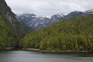
Gwaii Haanas National Park Reserve, National Marine Conservation Area, and Haida Heritage Site, usually referred to simply as Gwaii Haanas, is located in southernmost Haida Gwaii, 130 kilometres off the mainland of British Columbia, Canada. Gwaii Haanas protects an archipelago of 138 islands, the largest being Moresby Island and the southernmost being Kunghit Island. "Gwaii Haanas" means "Islands of Beauty" in X̱aayda kíl, the language of the Haida people.

British Columbia is the westernmost province of Canada, bordered by the Pacific Ocean. With an area of 944,735 km2 (364,764 sq mi) it is Canada's third-largest province. The province is almost four times the size of the United Kingdom and larger than every United States state except Alaska. It is bounded on the northwest by the U.S. state of Alaska, directly north by Yukon and the Northwest Territories, on the east by Alberta, and on the south by the U.S. states of Washington, Idaho, and Montana. Formerly part of the British Empire, the southern border of British Columbia was established by the 1846 Oregon Treaty. The province is dominated by mountain ranges, among them the Canadian Rockies but dominantly the Coast Mountains, Cassiar Mountains, and the Columbia Mountains. Most of the population is concentrated on the Pacific coast, notably in the area of Vancouver, located on the southwestern tip of the mainland, which is known as the Lower Mainland. It is the most mountainous province of Canada.

Vaseux Lake Provincial Park is a provincial park located along the northeastern shore of Vaseux Lake in the Okanagan region of British Columbia, Canada. The park is situated 4 kilometres (2.5 mi) south of Okanagan Falls on Highway 97 in the south Okanagan. The park plays a key role in educating and providing access to important conservation values and has a responsibility to maintain these activities.

BC Parks is an agency of the British Columbia Ministry of Environment and Climate Change Strategy that manages all of the, as of 2020, 1,035 provincial parks and other conservation and historical properties of various title designations within the province's Parks oversaw of the British Columbia Parks and Protected Areas System. The Lieutenant Governor-in-Council created the agency on March 1, 1911, through the Strathcona Park Act. The agency is charged with a dual role of preserving the ecological and historical integrity of the places entrusted to its management, while also making them available and accessible for public use and enjoyment.
Moresby Island is a large island that forms part of the Haida Gwaii archipelago in British Columbia, Canada, located at 52°45′00″N131°50′00″W. It is separated by the narrow Skidegate Channel from the other principal island of the group to the north, Graham Island.

Vaseux Lake is a shallow freshwater lake located along the course of the Okanagan River in the Okanagan Valley of British Columbia, Canada.
The Pacific Maritime Ecozone, as defined by the Commission for Environmental Cooperation (CEC), is a Canadian terrestrial ecozone, spanning a strip approximately 200 kilometres wide along the British Columbia Coast, then narrowing along the border with Alaska. It also includes all marine islands of British Columbia and a small portion of the southwestern corner of the Yukon. Fourteen ecoregions comprise the Ecozone, ranging from the Mount Logan Ecoregion in the north to the Cascade Ecoregion and Lower Mainland Ecoregion in the south.

SG̱ang Gwaay Llnagaay, commonly known by its English name Ninstints, is a village site of the Haida people and part of the Gwaii Haanas National Park Reserve and Haida Heritage Site on Haida Gwaii on the North Coast of British Columbia, Canada.
Hotspring Island, originally named in English as Volcanic Island and known in the Haida language as G̱andll K'in Gwaayaay ("Hot-Water-Island"), is a small island near the southeast coast of Lyell Island in the Haida Gwaii archipelago of the North Coast of British Columbia, Canada. The island's names derive from a hot spring located on its southwestern end, the temperature of which has been measured at 162 °F (72 °C). The island is part of Gwaii Haanas National Park Reserve and Haida Heritage Site and is supervised by the Haida Gwaii Watchmen.

The following outline is provided as an overview of and topical guide to British Columbia:
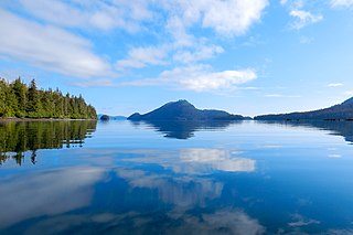
Gwaii Haanas National Marine Conservation Area Reserve and Haida Heritage Site is a National Marine Conservation Area of Canada. It is located off the coast of the southernmost Haida Gwaii, 130 kilometres off the mainland of British Columbia. It is immediately adjacent to Gwaii Haanas National Park Reserve and Haida Heritage Site. The level of protection differs from that of the National Park Reserve, however, allowing sustainable use of some natural resources in the area. Gwaii Haanas National Marine Conservation Area Reserve, which covers 3,400 square kilometres, is "a primary feeding habitat" of the humpback whale protected by Canada's Species at Risk Act (SARA).
Vaseux Protected Area is a provincial park in the Okanagan region of British Columbia, Canada. It was established on April 18, 2001 to protect the habitats of a number of blue-listed and red-listed species, most notably the winter rangeland for California Bighorn Sheep. The protected area adds to the similarly sized Vaseux-Bighorn National Wildlife Area that was established by the Canadian Wildlife Service in 1979.
Vaseux-Bighorn National Wildlife Area is a National Wildlife Area in British Columbia, Canada, primarily set aside to protect winter rangeland for California bighorn sheep. In 1979, the Vaseux-Bighorn Wildlife Area was established in response to substantial reduction in wild animal populations in the area. Identified factors contributing to species decline at the time were high predator population, overharvesting of species, and illegal hunting. Land development, cattle raising, and lumbering also might have altered species populations. Under these conditions, the area was able to be classified as a Category IV area by the IUCN and is now used for wildlife habitat and conservation. Even with minimal anthropogenic use of the area, threats persist through invasive species. Recreational use is limited spatially and is only open to the public during the day.

Hlk'yah G̱awG̱a, also known as Windy Bay, is located on Athlii Gwaii in southern Haida Gwaii, British Columbia. The site was historically the location of a Haida village named Hlk'yah Llnagaay, meaning Peregrine Falcon Town in English. In the 1980s, Hlk'yah G̱awG̱a was the focus of a series of lawsuits and protests opposing clearcut logging on the island. These demonstrations were the impetus for the signing of the Gwaii Haanas Agreement of 1993 and the creation of the Gwaii Haanas National Park Reserve, National Marine Conservation Area Reserve, and Haida Heritage Site.

White Lake Grasslands Protected Area is a protected area located in the Regional District of Okanagan-Similkameen of British Columbia, Canada. It was established on April 18, 2001 by order-in-council under the Environment and Land Use Act to protect the semi-arid grassland and pine forest ecosystem west of Vaseux Lake.
Duu Guusd Heritage Site/Conservancy is a heritage site and conservancy located in the northwest corner of Graham Island in the Haida Gwaii archipelago of British Columbia, Canada. It was established on March 23, 2008 to protect the ecological integrity and cultural importance of the region. The conservancy is part of an archipelago-wide system of protected areas that includes Gwaii Haanas National Park Reserve and Haida Heritage Site, Gwaii Haanas National Marine Conservation Area Reserve and Haida Heritage Site, and 17 other provincially protected areas.