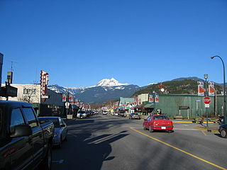
Squamish is a community and a district municipality in the Canadian province of British Columbia, located at the north end of Howe Sound on the Sea to Sky Highway. The population of the Squamish census agglomeration, which includes First Nation reserves of the Squamish Nation although they are not governed by the municipality, is 24,232.

Garibaldi Provincial Park, also called Garibaldi Park, is a wilderness park located on the coastal mainland of British Columbia, Canada, 70 kilometres (43.5 mi) north of Vancouver. It was established in 1920 and named a Class A Provincial Park of British Columbia in 1927. The park is a popular destination for outdoor recreation, with over 30,000 overnight campers and over 106,000 day users in the 2017/2018 season.

Porteau Cove Provincial Park is a provincial park located along the eastern shore of Howe Sound in British Columbia, Canada.

Alice Lake Provincial Park is a provincial park in British Columbia, Canada.
Banana Island Provincial Park is a provincial park in British Columbia, Canada. It is a small 10.4 hectare island in the South Thompson River, located approximately 35 kilometres east of Kamloops. There are no camping or recreational facilities, as it is an environmentally sensitive area. The island was designated as a provincial park on 30 April 1996 following recommendations from the Kamloops Land and Resource Management Plan to protect spring salmon spawning grounds and nesting grounds for several varieties of birds. It is used for nesting by Canada geese, Osprey and bald eagles, and other waterfowl and raptors. It is also a winter habitat for Tundra and Trumpeter swans. The island is vegetated with ponderosa pine and grassy undercover, and was historically used by the Neskonlith First Nation in accessing river resources.

Quatsino Provincial Park is a provincial park in British Columbia, Canada, located on Quatsino Sound on northern Vancouver Island.
Animals of Conkle Lake Provincial Park
Collinson Point Provincial Park is a provincial park on Galiano Island, British Columbia, Canada. It is located between Mount Galiano and the western approaches to Active Pass. The area is 24 hectares, with c. 500 metres of waterfront.
French Beach Provincial Park is a provincial park in British Columbia, Canada.

Ruckle Provincial Park is a provincial park on Salt Spring Island, British Columbia, Canada. It has the largest provincial campground on the Gulf Islands. Partly protected by the park is a historic sheep farm founded by the Ruckle family.
Spatsizi Plateau Wilderness Provincial Park is located in the northern portion of British Columbia, Canada, approximately 698, 659 hectares and encompasses the Spatsizi River and Gladys Lake Ecological Reserve. The park is a designated protected area that is intended for the conservation and research on caribou, grizzly bears, fish, and other wildlife species populations. Before the provincial park's establishment in 1975, the area was a historical hunting ground for local Indigenous communities like the Tahltan First Nations.It is the second largest provincial park in British Columbia.
Stuart River Provincial Park is a provincial park in British Columbia, Canada. It is located in two sections north and northwest of Vanderhoof along the Stuart River southeast of Stuart Lake and the city of Fort St. James. The upper section is located at 54°13′20″N124°00′00″W and comprises c.7391 ha. while the lower, eastern section is centred at 54°03′00″N123°37′00″W and comprises c.3390 ha. and is within the Greater Prince George area. The upper site, which is located around the confluence of the Stuart and Nechako Rivers, includes the site of Chinlac, a Dakelh village whose inhabitants were massacred and enslaved by the Tsilhqot'in of Anahim Lake c. 1745.

Tantalus Provincial Park is a provincial park located in the Tantalus Range overlooking Squamish Valley in British Columbia, Canada. It was established on December 19, 1998 to protect a large area of pristine alpine wilderness.
Tweedsmuir South Provincial Park is a provincial park covering parts of the eastern Kitimat Ranges, northern Pacific Ranges, and the Rainbow Range in British Columbia, Canada. It was established on May 21, 1938 in the western interior of the province, to protect its important natural features. The park hosts a variety of recreation activities for visitors. This park encompasses a range of diverse species in this park including bears, moose, and various fish. There are also a few at risk species in this park.

Brackendale is a small community in the Canadian province of British Columbia just north of Squamish town centre, but still within the District of Squamish. It is located near the confluence of the Squamish River and the Cheakamus River. It is intersected primarily by Government Road and Depot Road. The CN railway traverses it north–south. It includes the remarkable "Eagle Run" area, the wintering home of thousands of bald eagles.

South Chilcotin Mountains Provincial Park is a provincial park in British Columbia, Canada, located on Highway 40 northwest of Lillooet, British Columbia. The park, which is 56,796 ha. in size, was established on April 18, 2001, and It was created out of a portion of the Spruce Lake Protected Area. The park is located on three Indigenous Nations: The Tsilhqot’in, St’at’imc, and Secwepemc.
Koksilah is a community located just southeast of the City of Duncan, British Columbia, Canada. Its name is derived, via that of the Koksilah River, from that of the Hwulqwselu people, one of the Hǝn̓q̓ǝmin̓ǝm̓-speaking peoples of the area today organized as the Cowichan Tribes and government.

Boundary Bay Wildlife Management Area is a wildlife management area encompassing the entire Canadian portion of Boundary Bay in the Lower Mainland of British Columbia. It was established by the British Columbia Ministry of Forests, Lands, Natural Resource Operations and Rural Development (FLNRORD) on 21 June 1995 to conserve critical habitat for migratory bird species and resident fish and marine mammal species. It is part of the larger Fraser River Delta Ramsar Site.
Scott Islands Marine National Wildlife Area is a National Wildlife Area off the northwestern tip of Vancouver Island in the Canadian province of British Columbia. Covering an area of 11,570.65 km2 (4,467.45 sq mi), it is the second largest protected area in British Columbia after Offshore Pacific Seamounts and Vents Closure and is the largest national wildlife area in Canada.
The Christie Islet Migratory Bird Sanctuary is a small migratory bird sanctuary on the south coast of British Columbia. It was established in 1962 by Environment and Climate Change Canada. Located in Howe Sound just south of Anvil Island, it is a small rocky island where seabirds nest, and Harbour seals roam the surrounding waters. To protect the birds' nesting habitat, public access to the islet is not allowed, however is it possible to observe birds by boat.
