Yoho National Park is a national park of Canada. It is located within the Rocky Mountains along the western slope of the Continental Divide of the Americas in southeastern British Columbia, bordered by Kootenay National Park to the south and Banff National Park to the east in Alberta. The word Yoho is a Cree expression of amazement or awe, and it is an apt description for the park's spectacular landscape of massive ice fields and mountain peaks, which rank among the highest in the Canadian Rockies.

Jasper National Park is a national park in Alberta, Canada. It is the largest national park within Alberta's Rocky Mountains spanning 11,000 km2 (4,200 sq mi). It was established as a national park in 1930 and declared a UNESCO World Heritage Site in 1984. Its location is north of Banff National Park and west of Edmonton. The park contains the glaciers of the Columbia Icefield, springs, lakes, waterfalls and mountains.

Banff National Park is Canada's oldest national park, established in 1885 as Rocky Mountains Park. Located in Alberta's Rocky Mountains, 110–180 kilometres (68–112 mi) west of Calgary, Banff encompasses 6,641 square kilometres (2,564 sq mi) of mountainous terrain, with many glaciers and ice fields, dense coniferous forest, and alpine landscapes. The Icefields Parkway extends from Lake Louise, connecting to Jasper National Park in the north. Provincial forests and Yoho National Park are neighbours to the west, while Kootenay National Park is located to the south and Kananaskis Country to the southeast. The main commercial centre of the park is the town of Banff, in the Bow River valley.

The Canadian Rocky Mountain Parks World Heritage Site is located in the Canadian Rockies. It consists of seven contiguous parks including four national parks:

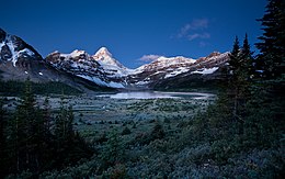
Mount Assiniboine, also known as Assiniboine Mountain, is a pyramidal peak mountain on the Great Divide, on the British Columbia/Alberta border in Canada.

Kootenay National Park is a national park of Canada in southeastern British Columbia. The park consists of 1,406 km2 (543 sq mi) of the Canadian Rockies, including parts of the Kootenay and Park mountain ranges, the Kootenay River and the entirety of the Vermilion River. While the Vermilion River is completely contained within the park, the Kootenay River has its headwaters just outside the park boundary, flowing through the park into the Rocky Mountain Trench and eventually joining the Columbia River. The park ranges in elevation from 918 m (3,012 ft) at the southwestern park entrance to 3,424 m (11,234 ft) at Deltaform Mountain.

Kananaskis Country is a multi-use area west of Calgary, Alberta, Canada in the foothills and front ranges of the Canadian Rockies. The area is named for the Kananaskis River, which was named by John Palliser in 1858 after a Cree acquaintance. Covering an area of approximately 4,000 km2 (1,500 sq mi), Kananaskis Country was formed by the Alberta Government in 1978 to provide an assortment of land uses and designations. Land uses include resource extraction activities, recreation, power generation, and residential communities. Land designations include public land and protected areas.

Garibaldi Provincial Park, also called Garibaldi Park, is a wilderness park located on the coastal mainland of British Columbia, Canada, 70 kilometres (43.5 mi) north of Vancouver. It was established in 1920 and named a Class A Provincial Park of British Columbia in 1927. The park is a popular destination for outdoor recreation, with over 30,000 overnight campers and over 106,000 day users in the 2017/2018 season.
Peter Lougheed Provincial Park is a provincial park located in Alberta, Canada. The park is in Kananaskis Country about 90 kilometres (56 mi) west of Calgary, along the Kananaskis Trail.

Banff Sunshine Village is a ski resort in western Canada, located on the Continental Divide of the Canadian Rockies within Banff National Park in Alberta and Mount Assiniboine Provincial Park in British Columbia. It is one of three major ski resorts located in the Banff National Park. Because of its location straddling the Continental Divide, Sunshine receives more snow than the neighbouring ski resorts. The Sunshine base area is located 15 km (9 mi) southwest of the town of Banff. By car, it is about a ninety-minute drive from the city of Calgary; the Sunshine exit on the Trans Canada Highway is 8 km (5 mi) west of the town of Banff.

Pinecone Burke Provincial Park is a provincial park in British Columbia, Canada. It extends from the southwest corner of Garibaldi Provincial Park, west of Pitt Lake and Pitt River to include Burke Mountain in the City of Coquitlam. Most of the park is unserviced wilderness with very rough trails such as the Fools Gold Trail in the Boise Valley. There is canoe access to Widgeon Slough and from there hiking trails that lead to Widgeon Lake, and a network of old logging roads, hiking and mountain biking trails on Burke Mountain. Visitors can also use the park for camping, backcountry skiing, and snowshoeing.

Hamber Provincial Park is a provincial park in British Columbia, Canada, located 130 kilometres (80.7 mi) north of Golden. Straddling the Great Divide on the provincial boundary with Alberta, the park is surrounded on three sides by Jasper National Park and protects the headwaters of the Wood River at Fortress Lake.
Height of the Rockies Provincial Park is a provincial park in the Canadian Rockies of south eastern British Columbia, Canada. It is located west of the Continental Divide, adjacent to Elk Lakes Provincial Park.
Tweedsmuir South Provincial Park is a provincial park covering parts of the eastern Kitimat Ranges, northern Pacific Ranges, and the Rainbow Range in British Columbia, Canada. It was established on May 21, 1938 in the western interior of the province, to protect its important natural features. Tweedsmuir Provincial Park is located on the unceded ancestral territory of the Nuxalk Nation. The park hosts a variety of recreation activities for visitors. This park encompasses a range of diverse species in this park including bears, moose, and various fish. There are also a few at risk species in this park.
The Stanley Mitchell hut is an alpine hut located at an altitude of 2,060 metres (6,759 ft) in the Little Yoho Valley in Yoho National Park, British Columbia. It sits in a small meadow not far from the base of a mountain called The President. It serves as a base for hiking, scrambling, ski-touring and climbing the nearby mountains. The hut is maintained by the Alpine Club of Canada.
The Elk Lakes cabin is an alpine hut located between the French and Italian Military Groups in the Canadian Rockies. It resides near the Continental Divide in Elk Lakes Provincial Park, British Columbia. It is 62 km south of the Trans-Canada Highway in Kananaskis Country, Alberta and 104 km north of Sparwood, British Columbia. The area has hiking trails, and provides access to mountaineering objectives. In winter, ice climbs and skiing terrain with much powder abound. Elk Lakes terrain is similar to that near the Elizabeth Parker hut. The hut is maintained by the Alpine Club of Canada.
The Skyline Trail is a hiking trail in Jasper National Park, Alberta, Canada. It is known for its views, with much of the hike being located above the tree line. It is also known for its challenging weather conditions above the tree line, which can be a problem for hikers, who can lose sight of trails.
Skoki Valley is a valley in Banff National Park in Alberta, Canada near the Town of Lake Louise. The valley is home to many lakes and passes such as Hidden Lake, Ptarmigan Lake and Deception Pass. The valley is popular among backcountry hikers, skiers and climbers because of its untouched snow and views. To accommodate skiers in the 1930s the Skoki Ski Lodge and Halfway Hut were built out of logs by local outfitters. The Red Deer Lakes which are the headwaters of the Red Deer River are located near the valley at the foot of Skoki Mountain.

Mount Seymour Provincial Park is a park in Vancouver, British Columbia's North Shore Mountains. With an area of 35 square kilometres, it is located approximately 15 kilometres north of Downtown Vancouver. The park, named after Frederick Seymour, was established in 1936. Mount Seymour Provincial Park provides visitors with a variety of recreational activities and animals with natural habitat.
Elizabeth von Rummel was a German-Canadian environmentalist and mountaineer. In 1980, she was made a Member of the Order of Canada.