
The Strait of Juan de Fuca is a body of water about 96 miles long that is the Salish Sea's main outlet to the Pacific Ocean. The international boundary between Canada and the United States runs down the centre of the Strait.

Lester B. Pearson United World College of the Pacific is one of eighteen schools and colleges around the world in the United World Colleges movement, located on Vancouver Island, Canada. It is named after the late Canadian Prime Minister Lester Bowles Pearson, winner of the 1957 Nobel Peace Prize, and an early champion of the college. The mission of the UWC movement and of the school is to "make education a force to unite people, nations and cultures for peace and a sustainable future".

Año Nuevo State Park is a state park of California, United States, encompassing Año Nuevo Island and Año Nuevo Point, which are known for their pinniped rookeries. Located in San Mateo County, the low, rocky, windswept point juts out into the Pacific Ocean about 55 miles (89 km) south of San Francisco and the Golden Gate. Año Nuevo State Natural Reserve, formerly a separate unit of the California state park system, was merged into Año Nuevo State Park in October 2008. The coastal geographic center, or coastal-midpoint of California is located at the Northern end of this park at N 37°09′58″, W 122°21'40", as the absolute geographic center of California falls at N 37°09′58″, W 119°26′58″W.

The northern elephant seal is one of two species of elephant seal. It is a member of the family Phocidae. Elephant seals derive their name from their great size and from the male's large proboscis, which is used in making extraordinarily loud roaring noises, especially during the mating competition. Sexual dimorphism in size is great. Correspondingly, the mating system is highly polygynous; a successful male is able to impregnate up to 50 females in one season.

Elephant seals are very large, oceangoing earless seals in the genus Mirounga. Both species, the northern elephant seal and the southern elephant seal, were hunted to the brink of extinction for oil by the end of the 19th century, but their numbers have since recovered. They are the largest extant carnivorans, weighing up to 5,000 kilograms (11,000 lb).

Gulf Islands National Park Reserve is a national park located on and around the Gulf Islands in British Columbia, Canada. In the National Parks System Plan, this park provides representation of the Strait of Georgia Lowlands natural region, the only place in Canada with a Mediterranean climate of dry, sunny summers and mild, wet winters, the result of a rain shadow effect from surrounding mountains between the region and the ocean. It has similar dominant vegetation as the Pacific Northwest, such as coastal Douglas-fir, western red cedar, shore pine, Pacific dogwood, bigleaf maple, and red alder, but also contains the northern extent of some of the more drought tolerant trees such as Garry oak and Arbutus. The park was created in 2003 as the fortieth national park. It covers 36 square kilometres (14 sq mi) of area on 16 islands and more than 30 islets, reefs and surrounding waters, making it the sixth smallest national park in Canada.

The Gulf Islands is a group of islands in the Salish Sea between Vancouver Island and the mainland coast of British Columbia.

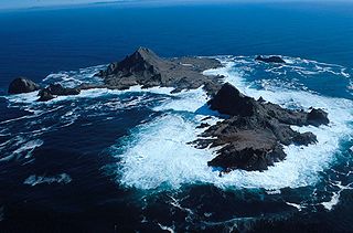
Race Rocks Light is one of the first two lighthouses that were built on the west coast of Canada, financed by the British Government and illuminated in 1860. It is the only lighthouse on that coast built of rock, (granite) purportedly quarried in Scotland, and topped with sandstone quarried on Gabriola Island. The Islands of Race Rocks are located just off the southern tip of Vancouver Island, about 16 km (10 mi) southwest of Victoria, British Columbia.

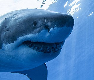
Año Nuevo Island is a small island off Año Nuevo Point on the coast of Northern California, between San Francisco and Santa Cruz. The island has an area of 9 acres (3.6 ha). It is an important breeding site for northern elephant seals and the endangered Steller's sea lion, as well as several species of seabirds, including rhinoceros auklets, Brandt's cormorants and western gulls. Due to the number of seals and sea lions, great white sharks are frequently spotted patrolling the waters around the island. It is protected as part of the Año Nuevo State Reserve.
The Farallon Islands, or Farallones, are a group of islands and sea stacks in the Gulf of the Farallones, off the coast of San Francisco, California, United States. The islands are also sometimes referred to by mariners as the Devil's Teeth Islands, in reference to the many treacherous underwater shoals in their vicinity. The islands lie 30 miles (48 km) outside the Golden Gate and 20 miles (32 km) south of Point Reyes, and are visible from the mainland on clear days. The islands are part of the City and County of San Francisco. The only inhabited portion of the islands is on Southeast Farallon Island (SEFI), where researchers from Point Blue Conservation Science and the U.S. Fish and Wildlife Service stay. The islands are closed to the public.

Cordell Bank National Marine Sanctuary is a marine sanctuary located off the coast of California. It protects an area of 1,286 sq mi (3,331 km2) of marine wildlife. The administrative center of the sanctuary is on an offshore granite outcrop 4.5 sq mi (12 km2) by 9.5 sq mi (25 km2), located on the continental shelf off of California. The outcrop is, at its closest, 6 mi (10 km) from the sanctuary itself.

The El Vizcaíno Biosphere Reserve, created in 1988, is located in Mulegé Municipality in northern Baja California Sur, at the center of the Baja California Peninsula between the Pacific Ocean and the Gulf of California. With an area of over 24,930 km2 (9,630 sq mi)), it is the largest wildlife refuge in Mexico and borders the northern edge of the Valle de los Cirios Protected Area of Flora and Fauna.

The Salish Sea is a marginal sea of the Pacific Ocean located in the Canadian province of British Columbia and the U.S. state of Washington. It includes the Strait of Georgia, the Strait of Juan de Fuca, Puget Sound, and an intricate network of connecting channels and adjoining waterways.
The Trial Islands Ecological Reserve is a nature reserve on the Trial Islands in the British Columbia province of Canada just off the southern tip of Oak Bay in the Strait of Juan de Fuca. The twenty-three-hectare ecological reserve was established in 1990 to protect two elongated rocky islands and associated islets. It protects the greatest number of endangered and vulnerable species in a single ecological reserve in British Columbia.

The southern elephant seal is one of two species of elephant seals. It is the largest member of the clade Pinnipedia and the order Carnivora, as well as the largest extant marine mammal that is not a cetacean. It gets its name from its massive size and the large proboscis of the adult male, which is used to produce very loud roars, especially during the breeding season. A bull southern elephant seal is about 40% heavier than a male northern elephant seal, twice as heavy as a male walrus, and 6–7 times heavier than the largest living mostly-terrestrial carnivoran, the polar bear and the Kodiak bear ,.

White Rock (Cambria) State Marine Conservation Area (SMCA) is a marine protected area located off the coast of the city of Cambria, California on California’s central coast. The marine protected area covers 2.32 square miles (6.0 km2). Within the SMCA the take of all living marine resources is prohibited except the commercial take of giant kelp and bull kelp under certain conditions.
Nitinat Lake is a large lake and inlet on the southwestern coast of Vancouver Island, British Columbia, Canada. The lake is about 150 km (93 mi) northwest by road from Victoria, BC's capital on the southern tip of Vancouver Island, and about 60 km (37 mi) southwest by road from the town of Lake Cowichan. The city of Port Alberni is about 80 km (50 mi) by road to the north.

Checleset Bay is a bay on the northwest coast of Vancouver Island, British Columbia, Canada. It is located southeast of Brooks Peninsula and northwest of Kyuquot Sound. Much of the land around the bay is part of Brooks Peninsula Provincial Park. Checleset Bay has three large inlets, Nasparti Inlet, Ououkinsh Inlet, and Malksope Inlet.
The Guadalupe Island Biosphere Reserve,, is located in the Pacific Ocean and is part of Baja California state of Mexico. The Reserve consists of Guadalupe Island and several small islands nearby plus a large expanse of surrounding ocean. The Reserve was created by the government of Mexico on 25 April 2005 and is located 250 kilometres (160 mi) from the mainland. The Reserve is 4,770 square kilometres (1,840 sq mi) in size of which 263 square kilometres (102 sq mi) is land and the remainder is water.
Scott Islands Marine National Wildlife Area is a National Wildlife Area off the northwestern tip of Vancouver Island in the Canadian province of British Columbia. Covering an area of 11,570.65 km2 (4,467.45 sq mi), it is the second largest protected area in British Columbia after Offshore Pacific Seamounts and Vents Closure and is the largest national wildlife area in Canada.


