
The Greenbelt is a 203.5-square-kilometre (78.6 sq mi) protected green belt traversing Ottawa, Ontario, Canada. It includes green space, forests, farms, and wetlands from Shirleys Bay in the west and to Green's Creek in the east. It is the largest publicly owned green belt in the world and the most ecologically diverse area in Eastern Ontario. The National Capital Commission (NCC) owns and manages 149.5 square kilometres (57.7 sq mi), and the rest is held by other federal government departments and private interests. Real estate development within the Greenbelt is strictly controlled.
Babine Lake Marine Provincial Park is a provincial park in British Columbia, Canada. The park was established by Order-in-Council in 1993, comprising two sites at Pendleton Bay totalling 36.9 hectares. Another was established in the same year at Smithers Landing, comprising approximately 157.8 hectares. Three more sites were added in 2001, Hook (Deep) Bay, Pierre Creek, Pinkut Creek and Sandpoint. All sites combined comprise approximately 492 hectares.

Tā Chʼilā Provincial Park, formerly Boya Lake Provincial Park, is a provincial park located in the Stikine Region of British Columbia, Canada. The park located 120 km north-by-northwest of the community of Dease Lake near BC Highway 37. Boya Lake is named for Charlie Boya, a First Nations man from the area.
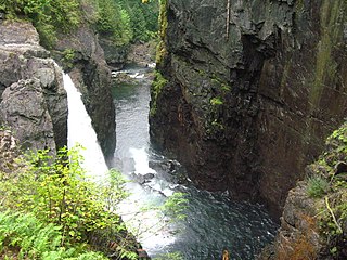
Elk Falls Provincial Park is a provincial park in British Columbia, Canada. It is 1,807 hectares in size and is located at the east end of John Hart Lake on the northwest side of the city of Campbell River, on Vancouver Island.
Goldpan Provincial Park is a provincial park in British Columbia, Canada, located on the Trans-Canada Highway between Lytton (W) and Spences Bridge (E), on the Thompson River. The park has camping above the highway and a picnic area and riverfront below.
High Lakes Basin Provincial Park is a provincial park in British Columbia, Canada.
Loveland Bay Provincial Park is a provincial park on Vancouver Island, British Columbia, Canada, located on the north side of Campbell Lake, just west of the city of Campbell River.
Main Lake Provincial Park is a provincial park on Quadra Island in British Columbia, Canada. Established in 1996 as Main Lakes Chain Park and renamed and expanded in 1997, the park encompasses a large wilderness area of six lakes with many diverse animal, bird and plant species. Opportunities for visitor observation and outdoor recreation include wilderness camping, canoeing, kayaking and hiking. Main Lake, Village Bay Lake and Mine Lake are connected by narrow, shallow marshes. Clear Lake, Stramberg Lake and Little Main Lake are accessible by hiking or rough portage.

Rebecca Spit Marine Provincial Park is a provincial park in British Columbia, Canada, located on the east side of Quadra Island, near the city of Campbell River.
Rock Bay Marine Provincial Park is a provincial park in British Columbia, Canada, located on the Inside Passage at the junction of Johnstone Strait and Discovery Passage. The park contains approximately 525 ha. Rock Bay is located on the shore of Vancouver Island, immediately south of East Thurlow Island.
Small Inlet Marine Provincial Park is a provincial park in British Columbia, Canada on the northwest side of Quadra Island, near the city of Campbell River.
Tranquil Creek Provincial Park is a provincial park in British Columbia, Canada, located at the head of the Kennedy River, east of the head of Bedwell Sound on Vancouver Island.
The Okanagan Indian Band is a First Nations government in the Canadian province of British Columbia, located in the city of Vernon in the northern Okanagan Valley. The band is a member government of the Okanagan Nation Alliance.
The Kluskus First Nation is the band government of the Lhoosk’uz, a Dakelh people whose main reserve located on the Chilcotin Plateau 130 km west of the city of Quesnel, British Columbia, Canada. The First Nation is a member of the Carrier-Chilcotin Tribal Council, which includes both Tsilhqot'in and Carrier (Dakelh) communities.
The Tŝideldel First Nation is the band government of the Tsi Del Del subgroup of the Tsilhqot'in people, located in the Chilcotin District in the western Central Interior region of the Canadian province of British Columbia. It is a member of the Tsilhqot'in National Government.

Ustlawn is a Squamish village community located on the shores of North Vancouver. The Squamish name Eslhá7an translates as head bay, denoted what used to be the farthest out reaching bay enclave in the Burrard Inlet. Its origin as a primary village goes back to the earliest missionaries in British Columbia with the St.Paul's Catholic Church being the oldest extant church in British Columbia, and a National Historic Site of Canada. It is also home to the Eslha7an Training Center, the Stitsma Employment Center, and the So-Sah-Latch Health and Family Centre. On the shores of the village is the Mosquito Creek Marina. The official name of the Indian reserve it is situated on is Mission Indian Reserve No. 1.
Burnaby Island is an island in Haida Gwaii off the north coast of British Columbia, Canada, located off the southeast coast of Moresby Island. It is part of the Gwaii Haanas National Park Reserve and Haida Heritage Site.
Griswold Pass is a mountain pass in the Pacific Ranges of the Coast Mountains of British Columbia, located at the head of Nichols Creek, a tributary of the upper Bridge River (S), and the head of Griswold Creek, a tributary of the Lord River (N), which feeds the Taseko Lakes and is effectively a tributary of the Taseko River. The Nichols Creek area is part of the volcanic formation known as the Bridge River Cones, while to the north of the pass the Taseko Lakes basin is part of Tsy'los Provincial Park.

The second HMS Fitzroy (K553) was a British Captain-class frigate of the Royal Navy in commission during World War II. Originally constructed as a United States Navy Buckley class destroyer escort, she served in the Royal Navy from 1943 to 1945.
The fourth HMS Rupert (K561) was a British Captain-class frigate of the Royal Navy in commission during World War II. Originally constructed as a United States Navy Buckley class destroyer escort, she served in the Royal Navy from 1943 to 1946.
