
Mount Robson Provincial Park is a provincial park in the Canadian Rockies with an area of 2,249 km². The park is located entirely within British Columbia, bordering Jasper National Park in Alberta. The B.C. legislature created the park in 1913, the same year as the first ascent of Mount Robson by a party led by Conrad Kain. It is the second oldest park in the provincial system. The park is named for Mount Robson, which has the highest point in the Canadian Rockies and is located entirely within the park.
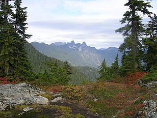
Cypress Provincial Park is a provincial park on the North Shore of Metro Vancouver Regional District, British Columbia. The park has two sections: a 21 km2 (8.1 sq mi) southern section which is accessible by road, and a 9 km2 (3.5 sq mi) northern section which is only accessible by hiking trails. Most of the park is in West Vancouver.

Kokanee Glacier Provincial Park is one of the oldest provincial parks in British Columbia, established in 1922. The park has an area of 320.35 km2 (123.69 sq mi) and is located in the Selkirk Mountains in the West Kootenays region of BC. The park has three glaciers that feed over 30 alpine lakes which are the headwaters of many creeks.

Akamina-Kishinena Provincial Park is a provincial park located in the southeastern corner of British Columbia, Canada. The park was established by order-in-council on July 13, 1995 to protect the ecological integrity of a relatively narrow stretch of the Rocky Mountains in the southeastern corner of the province.

Pinecone Burke Provincial Park is a provincial park in British Columbia, Canada. It extends from the southwest corner of Garibaldi Provincial Park, west of Pitt Lake and Pitt River to include Burke Mountain in the City of Coquitlam. Most of the park is unserviced wilderness with very rough trails such as the Fools Gold Trail in the Boise Valley. There is canoe access to Widgeon Slough and from there hiking trails that lead to Widgeon Lake, and a network of old logging roads, hiking and mountain biking trails on Burke Mountain.

Cathedral Provincial Park and Protected Area, usually known as Cathedral Provincial Park and also as Cathedral Park, is a provincial park in British Columbia, Canada. It is located east of E.C. Manning Provincial Park, south of BC Highway 3, and southeast of the town of Princeton and southwest of Keremeos. Its southern boundary is the border with the United States. Much of the park is the basin of the Ashnola River.
Coquihalla River Provincial Park is a provincial park in British Columbia, Canada, located 25 km (16 mi) north of the town of Hope on BC Highway 5 adjacent to the Coquihalla River.
Cody Caves Provincial Park is a provincial park in British Columbia, Canada. It was formed in July 1966 to protect the Cody Caves and was the first subterranean park in British Columbia. The park is 13 km by road, northwest from the hot springs community of Ainsworth Hot Springs on Kootenay Lake.
Dune Za Keyih Provincial Park and Protected Area, also known as the Frog-Gataga Provincial Park, is a provincial park in British Columbia, Canada. It is part of the larger Muskwa-Kechika Management Area and is located in the area of the Gataga River, between Denetiah Provincial Park, which lies west across the Kechika River, and Kwadacha Wilderness Provincial Park to its east. Established in 2001 as Frog-Gataga, the park is 346,833 hectares in area; its newer name is a Kaska Dena translation of Frog-Gataga.
Duffey Lake Provincial Park is a provincial park in British Columbia, Canada, located at the lake of the same name, which lies along BC Highway 99 just east of the summit of Cayoosh Pass. The lake's inflow and outflow are Cayoosh Creek. The park's highest point is Mount Rohr at the westernmost boundary.
Elk Lakes Provincial Park is a provincial park in southeastern British Columbia, Canada, located west of the continental divide. It is located adjacent to Height of the Rockies Provincial Park and is about 104 kilometers north of Sparwood. The park features sub-alpine landscapes, remnant glaciers, rugged peaks and productive lakes. Much of the park is above treeline and features several prominent mountains including Mount Fox, Mount Aosta, Mount McCuaig, and Mount Elkan. The Petain, Castelnau, Nivelle, and Elk Glaciers lie on the northeastern edge of the park. The following lakes are also present inside park boundaries: Upper and Lower Elk Lake, Frozen Lake, Fox Lake, Cadorna Lake, and Abruzzi Lake. Below the treeline, the park features mature growth forests of alpine fir, Engelmann spruce, and lodgepole pine. These trees are also intermingled with juniper, twinberry, false azalea, white rhododendron, and buffalo berry. The wildlife of the area includes Beaver, Snowshoe Hare, Red Squirrel, white-tailed deer, moose, and many varieties of birds.
Hole-in-the-Wall Provincial Park is a provincial park located in the Hart Ranges of British Columbia, Canada. It was established on June 29, 2000 to protect a resurgent spring which emerges from the base of a limestone rock wall. The spring forms a powerful stream that flows into the Sukunka River at the northern end of the park.

Itcha Ilgachuz Provincial Park is a provincial park in the Chilcotin Country of British Columbia, Canada. The park is 111,977 hectares in size and contains Far Mountain and Mount Downton, its two most prominent peaks.

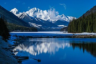
Mount Assiniboine Provincial Park is a provincial park in British Columbia, Canada, located around Mount Assiniboine.
Mount Edziza Provincial Park is a provincial park located in the northern portion of Kitimat-Stikine Regional District in British Columbia, Canada. It was established on 27 July 1972 to protect the volcanic landscape of Mount Edziza and the surrounding Tahltan Highland.
Mount Fernie Provincial Park is a provincial park located just west of the town of Fernie in British Columbia, Canada. It was established on May 4, 1959 to protect the ecology of the lower Lizard River while providing recreational opportunities for local residents and visitors alike. The park is named after Mount Fernie, a prominent peak located north of the park.

Mount Maxwell Provincial Park is a provincial park in the Gulf Islands of British Columbia, Canada. It is located on Burgoyne Bay and the Sansum Narrows on the western shores of Saltspring Island.

The Purcell Wilderness Conservancy is a provincial park in British Columbia, Canada. It was established in 1974, and encompasses six large drainages in the Purcell Mountains in the southeast of the province. It contains high peaks, alpine meadows and ridges, deep creek and river valleys, and hot springs at Dewar Creek.
Sustut Provincial Park and Protected Area is a provincial park in British Columbia, Canada, located on the east side of the Sustut River and above the Bear River. Established by order-in-council in 2001, the park has an area of 75,037 ha. The park protects the Hogem Ranges and the Connelly Range and is in the traditional territories of the Tsay Keh Dene First Nation and the Gitxsan First Nation.
Tweedsmuir South Provincial Park is a provincial park covering parts of the eastern Kitimat Ranges, northern Pacific Ranges, and the Rainbow Range in British Columbia, Canada. It was established on May 21, 1938 to protect a vast area of pristine wilderness in the western interior of the province.
