
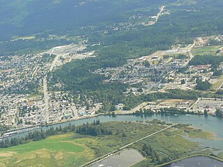
Port Alberni is a city located on Vancouver Island in the province of British Columbia, Canada. The city lies within the Alberni Valley at the head of the Alberni Inlet, Vancouver Island's longest inlet. It is the location of the head offices of the Alberni-Clayoquot Regional District. Port Alberni currently has a total population of 18,259.

The Martin JRM Mars is a large, four-engined cargo transport flying boat designed and built by the Martin Company for the United States Navy during World War II. It was the largest Allied flying boat to enter production, although only seven were built. The United States Navy contracted the development of the XPB2M-1 Mars in 1938 as a long-range ocean patrol flying boat, which later entered production as the JRM Mars long-range transport.
Englishman River is a river in the eastern side of Vancouver Island, British Columbia, Canada. It starts on the eastern slopes of the Beaufort Range, originating from tiny Jewel Lake and flowing in an easterly direction for 40 km (25 mi), entering the Strait of Georgia at Parksville, British Columbia. It is an important watershed providing habitat for various species of salmon and community water to the residents of Parksville and surrounding area. The Englishman River watershed includes Arrowsmith Lake, Hidden Lake, Fishtail Lake, Rowbotham Lake, Healy Lake, Shelton Lake, and Rhododendron Lake.
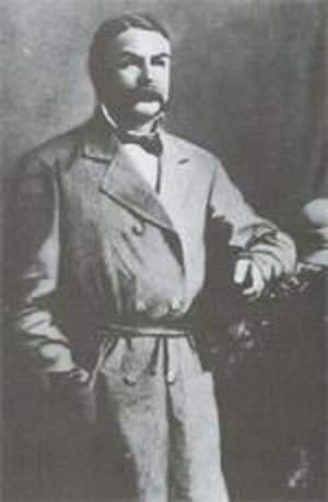
Gilbert Malcolm Sproat was a Scottish-born Canadian businessman, office holder, and author.
Ethel F. Wilson Memorial Provincial Park is a provincial park in central British Columbia, Canada. The park is situated on the northern tip of Pinkut Lake. Activities in the park include rainbow trout fishing and boating. The park has five campsites that are allocated on a first-come first-served basis. The area of the park is 33 hectares.

Fossli Provincial Park is a provincial park in British Columbia, Canada, located on Stirling Arm of Sproat Lake on Vancouver Island. The 52-hectare park, west of Port Alberni, is accessible by water or private logging road. It has few services, but has a 30-minute hiking trail to an old homestead site. The homestead belonged to Helen and Armour Ford, who donated the land for the park to the province in 1974. Saint Andrew's Creek runs through the park, and is a fall spawning ground for coho salmon.
Halkett Bay Marine Provincial Park is a provincial park off Gambier Island in British Columbia, Canada.

Little Qualicum Falls Provincial Park is a provincial park in British Columbia, Canada, on central Vancouver Island, that encompasses the entire southern shore of Cameron Lake. The Island Rail Corridor line to Port Alberni passes through the park.
Monkman Provincial Park is a provincial park in British Columbia, southwest of Tumbler Ridge and northeast of Hansard. Like Monkman Pass, Monkman Lake, Monkman Creek and Monkman Falls, it was named after Alexander Monkman.

White Lake Provincial Park is a provincial park in British Columbia, Canada and is located 10 kilometres northeast of Balmoral, British Columbia. Established in 1965, the park is just west of Cedar Creek Camp, a park owned by the not-for-profit organisation of People In Motion. The lake is popular with anglers fishing for rainbow trout; in terms of angler days, it is one of the top three fishing lakes in the province.

Smuggler Cove Marine Provincial Park is a provincial park in British Columbia, Canada.

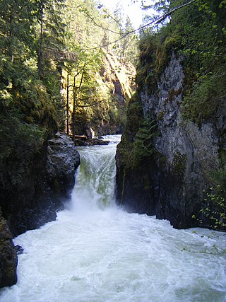
Stamp River Provincial Park is a provincial park in British Columbia, Canada. The 327-hectare park is located 14 km north of Port Alberni on Vancouver Island. There are 23 camping spaces and 2 km of trails within the park along the Stamp River, named for Edward Stamp, a sawmill pioneer in the Alberni Valley.
Taylor Arm Provincial Park is a provincial park in British Columbia, Canada, located on the north side of Sproat Lake 23 km northwest of Port Alberni on Vancouver Island. Situated along Highway 4, the 71-hectare park has few services but provides group camping sites, undeveloped beaches, and day-use areas. The group camping site has pit toilets and a hand pump water supply, and is connected to the lake shore via a trail that passes under the highway.
Tranquil Creek Provincial Park is a provincial park in British Columbia, Canada, located at the head of the Kennedy River, east of the head of Bedwell Sound on Vancouver Island.

Great Central Lake is a lake on Vancouver Island, British Columbia, Canada. It is located north of Sproat Lake and to the northwest of the city of Port Alberni. It is 45 kilometres (28 mi) long, with an area of 50.85 square kilometres (19.63 sq mi) and mean depth of 124 metres (407 ft), to a maximum of 250 metres (820 ft), making it the second deepest lake on Vancouver Island. The lake is long and narrow, with the exception of Trestle Bay located on the east end of the lake. It is nestled beneath low mountains, with second-growth forest surrounding most of the lake. The water level is controlled by a dam on the east side.
Franklin River in Vancouver Island, British Columbia, is located between Alberni Inlet and Barkley Sound, was named as part of the Vancouver Island Exploration Expedition of 1864. The river was named for Selim Franklin, Esquire, who was Chairman of the Exploration Committee.
Sproat Lake is a lake on central Vancouver Island in British Columbia, Canada. It was known as Kleecoot, meaning "wide open" by local indigenous people.

Alberni Valley is a broad valley located at the head of Alberni Inlet on Vancouver Island in British Columbia, Canada. It is home to Port Alberni, Sproat Lake and other outlining areas. The term is largely used as a synonym for Greater Port Alberni and adjoining communities but is used in a larger regional sense as well. Various local organizations and companies use the term "Alberni Valley" in their name, e.g. the Alberni Valley Times and Alberni Valley News newspapers the Alberni Valley Chamber of Commerce and the Alberni Valley Bulldogs minor hockey team. The Canadian pioneer, Joe Drinkwater lived in Alberni Valley during the late nineteenth and early twentieth centuries.
Somass River is a river on Vancouver Island, in the Canadian province of British Columbia. Its drainage basin is 1,412 square kilometres (545 sq mi) in size.

