
Babine Lake Marine Provincial Park is a provincial park in British Columbia, Canada. The park was established by Order-in-Council in 1993, comprising two sites at Pendleton Bay totalling 36.9 hectares. Another was established in the same year at Smithers Landing, comprising approximately 157.8 hectares. Three more sites were added in 2001, Hook (Deep) Bay, Pierre Creek, Pinkut Creek and Sandpoint. All sites combined comprise approximately 492 hectares.
Bligh Island Marine Provincial Park is a provincial park in British Columbia, Canada.
Catala Island Marine Provincial Park is a provincial park in British Columbia, Canada, located on the west coast of Vancouver Island at the mouth of Esperanza Inlet, between Kyuquot Sound (N) and Nootka Sound (S). The park is 955 ha. in size and was established in July 1995.
Copeland Islands Marine Provincial Park is a provincial park in British Columbia, Canada, located in Desolation Sound to the northwest of Lund on the northern Sunshine Coast off the west coast of the Malaspina Peninsula.
Claud Elliott Provincial Park is a provincial park in British Columbia, Canada located on northern Vancouver Island approximately 50 kilometres (31 mi) southeast of Port McNeill, between the Tsitsika River and Bonanza Lake, near the community of Woss.
Dixie Cove Marine Provincial Park, originally Dixie Cove Provincial Park, is a provincial park in British Columbia, Canada, located on the east side of Hohoae Island, which is just west of Fair Harbour in Kyuquot Sound on the West Coast of Vancouver Island.
Echo Bay Marine Provincial Park is a provincial park in British Columbia, Canada, established in 1971 and containing 1.5 hectares. It is located at the bay of the same name, offshore from the community of the same name, which is the location of the Simoom Sound post office and is on the west side of Gilford Island.
God's Pocket Marine Provincial Park is a provincial park in southwest British Columbia, Canada, established July 12, 1995. It is well known as a cold water scuba diving and kayaking destination. The park is 2,036 hectares in size, and includes two main islands, Hurst and Bell islands respectively, and many smaller isles.
Háthayim Marine Provincial Park, formerly Von Donop Marine Provincial Park, is a provincial park in British Columbia, Canada, located on the north end of Cortes Island in the Discovery Islands.
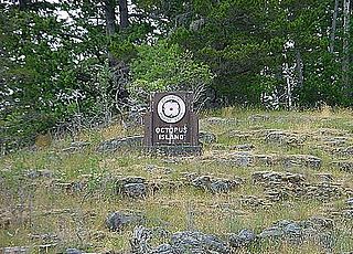
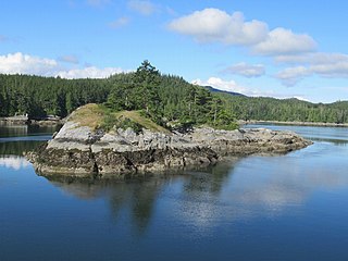
Octopus Islands Marine Provincial Park is a provincial park in British Columbia, Canada. It is located between Quadra Island and Maurelle Island in Okisollo Channel.

Nuchatlitz Provincial Park is a provincial park in British Columbia, Canada, located no the northwest side of Nootka Island, facing Nuchatlitz Inlet, on the west coast of Vancouver Island. Established in 1996, the park contains approximately 2105 ha.

Rock Bay Marine Provincial Park is a provincial park in British Columbia, Canada, located on the Inside Passage at the junction of Johnstone Strait and Discovery Passage. The park contains approximately 525 ha. Rock Bay is located on the shore of Vancouver Island, immediately south of East Thurlow Island.
Sabine Channel Provincial Park, also known as Sabine Channel Marine Provincial Park, is a provincial park in British Columbia, Canada, in the waters surrounding Jervis Island in Sabine Channel, which separates Texada Island (N) from Lasqueti Island (S). Established in 2001, the parks is approximately 2,254 ha. in size.
Thurston Bay Marine Provincial Park is a provincial park on the northwest side of Sonora Island in British Columbia, Canada.
Broughton Archipelago is a group of islands located at the eastern end of Queen Charlotte Strait in Mount Waddington Regional District, British Columbia. The archipelago is the traditional territory of the Musgamagw Dzawada'enuxw, Namgis, Ma'amtagila and Tlowitsis nations of the Kwakwaka'wakw peoples.
Robson Bight is a small Vancouver Island bay at the west end of Johnstone Strait across from West Cracroft Island in British Columbia, Canada that includes a protected killer whale habitat famous for its whale-rubbing beaches. The bight is adjacent to Lower Tsitika River Provincial Park. The nearest access point is Telegraph Cove on the east coast of Northern Vancouver Island.
Cormorant Island is an island in Queen Charlotte Strait on the Central Coast of British Columbia, Canada. It has a total land area of about 4 square km and is located south of Malcolm Island and east of Port McNeill.
Tribune Channel is a channel or strait on the Central Coast of British Columbia, Canada, separating Gilford Island on the west and north from the mainland. The channel bends around Gilford Island, with the mouth of Thompson Sound at the elbow of the bend, opening eastwards to the mouth of the Kakweiken River.
The Pearse Islands are a small group of islands in the Queen Charlotte Strait region of the Central Coast of British Columbia, Canada. They are just east of Cormorant Island, which is the location of the Village of Alert Bay. Cormorant Channel Marine Provincial Park is located in this group of islands.
Crease Island, formerly Lewis Island, is an island in the Broughton Archipelago Marine Provincial Park in the Queen Charlotte Strait-Johnstone Strait region of the Central Coast of British Columbia, Canada. It is located north of Harbledown Island and is at the southern extremity of the provincial park.
