
Vancouver Island is an island in the northeastern Pacific Ocean and part of the Canadian province of British Columbia. The island is 456 km (283 mi) in length, 100 km (62 mi) in width at its widest point, and 32,100 km2 (12,400 sq mi) in total area, while 31,285 km2 (12,079 sq mi) are of land. The island is the largest by area and the most populous along the west coasts of the Americas.

Saysutshun Provincial Park, formally known as Newcastle Island Marine Provincial Park, is a provincial park located on a small island off the coast of Nanaimo, British Columbia, Canada.

Coombs is a small community on Vancouver Island in the Regional District of Nanaimo, British Columbia, situated on provincial highway 4A approximately 10 km (6.2 mi) west of Parksville. According to the 2021 census, Coombs is home to 1672 people.

Parksville is a city on Vancouver Island in British Columbia, Canada. As of the 2021 Census, Parksville's population was 13,642, representing a 9.5% increase over the 2016 Census.
Highway 4 is the longest east–west main vehicle route on Vancouver Island, British Columbia, Canada, with a total length of 162 km (101 mi). It is known locally as the Alberni Highway to the east of Port Alberni and the Pacific Rim Highway to the west. The original highway from Parksville to Alberni and Port Alberni was completed in 1942 and was originally designated as Highway 1A. It was re-designated as Highway 4 in 1953, and was extended in 1961 to the district of Tofino, on the west coast of the Island.

Qualicum Beach is a town located on Vancouver Island, British Columbia, Canada. In the 2021 census, it had a population of 9,303. It is situated at the foot of Mount Arrowsmith, along the Strait of Georgia on Vancouver Island's northeastern coast.

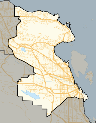
The Regional District of Nanaimo is a regional district located on the eastern coast of Vancouver Island, British Columbia, Canada. It is bordered to the south by the Cowichan Valley Regional District, to the west by the Alberni-Clayoquot Regional District, and to the northwest by the Comox Valley Regional District. Its administration offices are located in Nanaimo. During the 2016 census, its population was established at 155,698.
Nanaimo is a provincial electoral district for the Legislative Assembly of British Columbia, Canada.

Little Qualicum Falls Provincial Park is a provincial park in British Columbia, Canada, on central Vancouver Island, that encompasses the entire southern shore of Cameron Lake. The Island Rail Corridor line to Port Alberni passes through the park.

Roberts Memorial Provincial Park is a 14 ha provincial park in British Columbia, Canada, located 15 km south of Nanaimo.

Bowser is a community on the east coast of Vancouver Island in British Columbia, Canada. It has a population of 1,729. Approximately 66 kilometres (41 mi) north of Nanaimo, Bowser is in a region informally known as Lighthouse Country, spanning a stretch of highway that extends from Qualicum Beach in the south to Horne Lake to the west and Fanny Bay in the north and east to Denman and Hornby Islands. Bowser is in the Regional District of Nanaimo and in its Electoral Area H, one of eight in the District. The community was named after William J. Bowser, premier of British Columbia from 1915 to 1916. Bowser is served by the coast-spanning Island Highway.
Errington is a small community on Vancouver Island, British Columbia, Canada, located on Errington Road, off Highway 4, just south of Parksville and Qualicum Beach.

Scott Kenneth Fraser is a Canadian politician who represented the Mid Island-Pacific Rim electoral district in the Legislative Assembly of British Columbia from 2005 to 2020. A member of the British Columbia New Democratic Party, he was first elected as a Member of the Legislative Assembly (MLA) in the 2005 election, defeating one-term Liberal Party incumbent Gillian Trumper, and re-elected in the 2009, 2013 and 2017 elections. During the 41st Parliament (2017-2020) he served in the Executive Council as the Minister of Indigenous Relations and Reconciliation. In that role he led the government through adopting the Declaration on the Rights of Indigenous Peoples Act, with all party support, to implement the United Nations' Declaration on the Rights of Indigenous Peoples (UNDRIP).
Adam Grant Horne was a Hudson's Bay Company employee at the Colony of Vancouver Island, a municipal politician and a businessman. He was born in Edinburgh, Scotland and died at Nanaimo, British Columbia. He married Elizabeth Bate whose brother, Mark Bate, also an HBC employee, was the first Mayor of Nanaimo.
Close To The Edge Provincial Park and Protected Area is a provincial park and a protected area in British Columbia, Canada.
The Qualicum River or Big Qualicum River is a river on the east coast of Vancouver Island, British Columbia, Canada, flowing northeast from its headwaters in Horne Lake into the Strait of Georgia just south of Qualicum Bay, near the town of Qualicum Beach. The river's name comes from that of the Qualicum people.

Horne Lake is located west of Qualicum Beach. Named after Adam Grant Horne, Hudson's Bay Company storekeeper at Nanaimo, who made the first recorded sighting of this lake in 1856.

Nanaimo River is a river on Vancouver Island, British Columbia, Canada, located near the city of Nanaimo on the island's east coast. Its headwaters are in the Vancouver Island Ranges of central Vancouver Island and its mouth, the Nanaimo River estuary, is at the south end of Nanaimo Harbour in the Strait of Georgia. The estuary is part of the Pacific Estuary Conservation Program.

Nanaimo Lakes are a chain of four lakes composed of three natural—First, Second, and Third Lakes—and one man-made, dammed lake, Fourth Lake, on the upper Nanaimo River, on Vancouver Island in British Columbia, Canada.
Mount Arrowsmith Biosphere Region (MABR) is a UNESCO Biosphere Reserve located on the east coast of Vancouver Island in British Columbia, Canada. It was designated in 2000 by UNESCO to protect a large second-growth coast Douglas fir ecosystem in the watersheds of the Little Qualicum and Englishman Rivers from being developed.


