
Northern Manitoba is a geographic and cultural region of the Canadian province of Manitoba. Originally encompassing a small square around the Red River Colony, the province was extended north to the 60th parallel in 1912. The region's specific boundaries vary, as "northern" communities are considered to share certain social and geographic characteristics, regardless of latitude.

The Great Bear Rainforest is a temperate rain forest on the Pacific coast of British Columbia, Canada comprising 6.4 million hectares. It is part of the larger Pacific temperate rainforest ecoregion, which is the largest coastal temperate rainforest in the world.
Cinnemousun Narrows Provincial Park is a provincial park in British Columbia, Canada, located on Shuswap Lake at the convergence of the lake's four arms.
Eakin Creek Floodplain Provincial Park is a provincial park in British Columbia, Canada located on the North Thompson River near the community of Little Fort.
Epsom Provincial Park is a provincial park in British Columbia, Canada, located west of Ashcroft around Oregon Jack Hill.
Elephant Hill Provincial Park is a provincial park in British Columbia, Canada protecting Elephant Hill, a prominent landmark adjacent to the Trans-Canada Highway at the cut-off for the town of Ashcroft a few miles south of the town of Cache Creek. The park is approximately 968 hectares in area.
Green Inlet Marine Provincial Park is a provincial park in British Columbia, Canada, located in the North Coast region to the southeast of Butedale and containing 33 ha.
Grohman Narrows Provincial Park is a provincial park in British Columbia, Canada.

Marble River Provincial Park is a provincial park in British Columbia, Canada. The park is located on northern Vancouver Island. It is 14.19 km2 (5.48 sq mi) in area. The park protects an eagle nesting habitat near Quatsino Narrows in Quatsino Sound, a steelhead fishery, and an extensive waterfowl habitat. A 4.2 km (2.6 mi)-long biking or walking trail is available, as well as opportunities for wildlife viewing.
Sechelt Inlets Marine Provincial Park is a provincial park in British Columbia, Canada, at various locations on Sechelt Inlet, Salmon Inlet and Narrows Inlet, near Sechelt. Established initially as a recreation area in 1980, it was converted to a park in 1999, containing approximately 140 hectares.
Shuswap Lake Marine Provincial Park is a provincial park in British Columbia, Canada, comprising 894 ha. The Park has a variety of amenities including boat launch ramps, picnic areas, and 27 campsites around the perimeter of Shuswap Lake. The lake's name and that of the surrounding Shuswap Country is from the Shuswap people (Secwepemc), the most northern of the Salishan speaking people.
Sunnybrae Provincial Park is a provincial park in British Columbia, Canada, located on the northern side of the Salmon Arm of Shuswap Lake, near the city of Salmon Arm. Sunnybrae is a day use park with washrooms, picnic tables, playground and swimming area.
Surge Narrows Provincial Park is a provincial park in British Columbia, Canada, located on the south tip of Maurelle Island and on adjacent islands in the Discovery Islands archipelago in that province's South Coast region.
The Pattullo Range is a subrange of the Hazelton Mountains, located south of Tesla Lake and northeast of Bella Coola in northern British Columbia, Canada. Its highest summit is Tsaydaychuz Peak, 2758 m.
Denny Island is an island on the Central Coast of British Columbia, Canada, just east of the community of Bella Bella, aka Waglisla, on Campbell Island. Denny Island is the location of Old Bella Bella, now mainly abandoned but home to Canadian Coast Guard and Fisheries & Oceans bases, and the locality of Shearwater, home to Shearwater Marine. Denny Island has a population of 138. Denny Island's shining glory is the McEmery Aquatic Centre located on Reservoir Lane.

Bodega Head State Marine Reserve (SMR) and Bodega Head State Marine Conservation Area (SMCA) are two adjoining marine protected areas off Bodega Bay in Sonoma County on California’s north-central coast. The combined area of these marine protected areas is 21.64 square miles (56.0 km2), with 9.3 square miles (24 km2) in the SMR, and 12.34square miles in the SMCA. Bodega Head SMR prohibits the take of all living marine resources. Bodega Head SMCA prohibits the take of all living marine resources, except the recreational and commercial take of pelagic finfish with troll fishing gear or seine, Dungeness crab by trap, and market squid by hand-held dip net and round haul net.
The Tower of London Range is a sub-range of the Northern Rocky Mountains in northern British Columbia, Canada, located northwest of the Tuchodi Lakes at the northwest end of the Northern Rocky Mountains Provincial Park to the southwest of Fort Nelson.

Seaforth Channel is a channel in the Central Coast region of the Canadian province of British Columbia which is part of the Inside Passage - the 950 miles (1,530 km) passage between Seattle, Washington and Juneau, Alaska. The marine highway goes through Seaforth Channel on the way to Milbanke Sound, one of the open sea portions of the Inland Passage. Seaforth Channel which is part of the Prince Rupert/Port Hardy BC ferry route, extends in a westerly direction from Denny Island to Milbanke Sound between Denny Island, Campbell Island and the Wright group of islands on the south. In October 2016, a Texas-owned tug/barge transiting the Canadian waters of the Inside Passage without a local pilot was hard grounded on a reef at the entrance to Seaforth Channel in October 2016. More than 100,000 l of fuel contaminated the coast, coves and shores 20 km (12 mi) west of Bella Bella, the core community of the Heiltsuk Nation as well as the environmentally sensitive Great Bear Rainforest - Canada's contribution to the Queen's Commonwealth Canopy (QCC), a network of forest conservation programs. Clean up response and salvage was criticized by the Heiltsuk, B.C. Premier Christy Clark and Prime Minister Justin Trudeau. In November in Vancouver the Prime Minister announced a $1.5B ocean protection plan to "create a marine safety system, restore marine ecosystems and undertake research into oil spill cleanup methods."
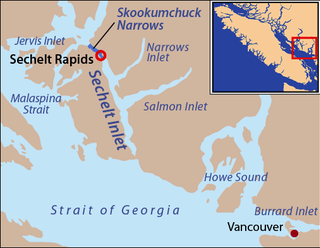
Narrows Inlet formerly Narrows Arm is a fjord branching east from Sechelt Inlet in British Columbia, Canada. Its companion, Salmon Inlet, another side-inlet of Sechelt Inlet, lies roughly 10 km (6.2 mi) south.
