Hinchinbrook Island National Park is Australia's largest island national park. It is situated along the Cassowary Coast Queensland, Australia. The nearest capital city is Brisbane approximately 1240 Lucinda is 135 km or 1.5 hours drive north of Townsville being the closest North Queensland provincial city. Cairns a Far North Queensland provincial city is two and a half to 3 hours drive north from Cardwell. The main geographical features in the park are the rugged Hinchinbrook Island, including Mount Bowen, The Thumb, Mount Diamantina and Mount Straloch.

Parts of this article have been adapted from the BC Parks website.

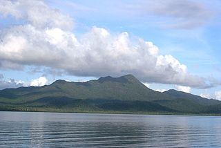
Bligh Island Marine Provincial Park is a provincial park in British Columbia, Canada.
Catala Island Marine Provincial Park is a provincial park in British Columbia, Canada, located on the west coast of Vancouver Island at the mouth of Esperanza Inlet, between Kyuquot Sound (N) and Nootka Sound (S). The park is 955 ha. in size and was established in July 1995.

Quatsino Provincial Park is a provincial park in British Columbia, Canada, located on Quatsino Sound on northern Vancouver Island.
Dixie Cove Marine Provincial Park, originally Dixie Cove Provincial Park, is a provincial park in British Columbia, Canada, located on the east side of Hohoae Island, which is just west of Fair Harbour in Kyuquot Sound on the West Coast of Vancouver Island.
Garden Bay Marine Provincial Park is a provincial park in British Columbia, Canada at the northwest end of the Sechelt Peninsula on the lower Sunshine Coast, near the community of Madeira Park. Established in 1969, it contains approximately 163 ha.
God's Pocket Marine Provincial Park is a provincial park in southwest British Columbia, Canada, established July 12, 1995. It is well known as a cold water scuba diving and kayaking destination. The park is 2,036 hectares in size, and includes two main islands, Hurst and Bell islands respectively, and many smaller isles.
Halkett Bay Marine Provincial Park is a provincial park off Gambier Island in British Columbia, Canada.
Harmony Islands Marine Provincial Park is a provincial park in British Columbia, Canada, located on the east side of Hotham Sound, which is a side-inlet of the lower reaches of Jervis Inlet, on that inlet's north side roughly opposite the mouth of Sechelt Inlet.

Lawn Point Provincial Park is a provincial park in British Columbia, Canada.

Pirates Cove Marine Provincial Park is a provincial park on De Courcy Island in British Columbia, Canada.
Sabine Channel Provincial Park, also known as Sabine Channel Marine Provincial Park, is a provincial park in British Columbia, Canada, in the waters surrounding Jervis Island in Sabine Channel, which separates Texada Island (N) from Lasqueti Island (S). Established in 2001, the parks is approximately 2,254 ha. in size.
Sechelt Inlets Marine Provincial Park is a provincial park in British Columbia, Canada, at various locations on Sechelt Inlet, Salmon Inlet and Narrows Inlet, near Sechelt. Established initially as a recreation area in 1980, it was converted to a park in 1999, containing approximately 140 hectares.

Simson Provincial Park is a provincial park in British Columbia, Canada.

Smuggler Cove Marine Provincial Park is a provincial park in British Columbia, Canada.
St. Mary's Alpine Provincial Park is a provincial park in British Columbia, Canada. According to the Canadian Ministry of the Environment:
St. Mary’s Alpine Park is a wilderness paradise for the experienced backcountry traveller. Numerous lakes and tarns are tucked against rugged granite cliffs and surrounded by tundra and lingering snowfields. Seven creeks drain the lakes, resulting in numerous waterfalls and cataracts, some as much as 150 metres in height. Experienced hikers, willing to expend considerable effort in bushwhacking and route finding should visit this protected area where few, if any, people will be encountered.
Kyuquot Sound is a complex of coastal inlets, bays and islands on northwestern Vancouver Island in the Canadian province of British Columbia.
Buffalo Point First Nation is an Ojibwa or Saulteaux First Nations located in the southeastern corner of Manitoba, along the shores of Lake of the Woods. It is bordered largely by the unorganized portion of Division No. 1, Manitoba, and also has smaller borders with the Rural Municipality of Piney, as well as the northeast corner of Roseau County, Minnesota.
Musket Island Marine Provincial Park is a provincial park in British Columbia, Canada, located on the west side of Nelson Island, at the mouth of Jervis Inlet and near Earl's Cove in the Sunshine Coast region.

