
Princess Royal Island is the largest island on the North Coast of British Columbia, Canada. It is located amongst the isolated inlets and islands east of Hecate Strait on the British Columbia Coast. At 2,251 square kilometres (869 sq mi), it is the fourth largest island in British Columbia. Princess Royal Island was named in 1788 by Captain Charles Duncan, after his sloop Princess Royal.
Babine Lake Marine Provincial Park is a provincial park in British Columbia, Canada. The park was established by Order-in-Council in 1993, comprising two sites at Pendleton Bay totalling 36.9 hectares. Another was established in the same year at Smithers Landing, comprising approximately 157.8 hectares. Three more sites were added in 2001, Hook (Deep) Bay, Pierre Creek, Pinkut Creek and Sandpoint. All sites combined comprise approximately 492 hectares.
Bishop River Provincial Park is a provincial park in the Pacific Ranges of the Coast Mountains on the Mainland of British Columbia, Canada, located southwest of and adjoining Ts'yl-os Provincial Park."Bishop River Park". BC Geographical Names. It lies along the upper course of the Bishop River, the main tributary of the Southgate River, from the Bishop's source at the western side of the Lillooet Icecap to midway along its course above its confluence with the Southgate. The park is 19,947 ha. in size. There are no roads or trails in the park although a forest service road from Waddington Harbour at the head of Bute Inlet leads up the Southgate to within a few miles of the park boundary.
Catala Island Marine Provincial Park is a provincial park in British Columbia, Canada, located on the west coast of Vancouver Island at the mouth of Esperanza Inlet, between Kyuquot Sound (N) and Nootka Sound (S). The park is 955 ha. in size and was established in July 1995.

Quatsino Provincial Park is a provincial park in British Columbia, Canada, located on Quatsino Sound on northern Vancouver Island.

Harmony Islands Marine Provincial Park is a provincial park in British Columbia, Canada, located on the east side of Hotham Sound, which is a side-inlet of the lower reaches of Jervis Inlet, on that inlet's north side roughly opposite the mouth of Sechelt Inlet.
Háthayim Marine Provincial Park, formerly Von Donop Marine Provincial Park, is a provincial park in British Columbia, Canada, located on the north end of Cortes Island in the Discovery Islands.
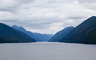
Jackson Narrows Marine Provincial Park is a provincial park in British Columbia, Canada, located on the west side of Mathieson Channel to the north of the community of Bella Bella.
Kitwanga Mountain Provincial Park is a provincial park in British Columbia, Canada located on the north side of the Skeena River just west of the Gitxsan community of Kitwanga (Gitwangak).

Lowe Inlet Marine Provincial Park is a provincial park in British Columbia, Canada located on the Inside Passage of the North Coast, 118 km south of Prince Rupert and 75 km north of Butedale. Established on 14 June 1994, the park now contains approximately 765 hectares.

Nuchatlitz Provincial Park is a provincial park in British Columbia, Canada, located no the northwest side of Nootka Island, facing Nuchatlitz Inlet, on the west coast of Vancouver Island. Established in 1996, the park contains approximately 2105 ha.
Princess Louisa Marine Provincial Park is a provincial park in British Columbia, Canada surrounding Princess Louisa Inlet.
Sechelt Inlets Marine Provincial Park is a provincial park in British Columbia, Canada, at various locations on Sechelt Inlet, Salmon Inlet and Narrows Inlet, near Sechelt. Established initially as a recreation area in 1980, it was converted to a park in 1999, containing approximately 140 hectares.
Small Inlet Marine Provincial Park is a provincial park in British Columbia, Canada on the northwest side of Quadra Island, near the city of Campbell River.
Warta-Widawka Landscape Park is a protected area in central Poland.
Watt Section is a rural community on the Eastern Shore of Nova Scotia, Canada, in the Halifax Regional Municipality. The community is located along Nova Scotia Trunk 7 on the Marine Drive, and is located about 5 km (3.1 mi) southeast of Sheet Harbour, Nova Scotia. The community is located along the eastern side of Sheet Harbour, an inlet of the Atlantic Ocean. The community is named for William Watt, who purchased the land at the present day location of the community in 1844. The cookhouse used at the lumber mill at the head of East River in Sheet Harbour was bought by the residents of Watt Section after the closing of the mill in January 1891, and it was floated down to the community.
Grenville Channel is a strait on the North Coast of British Columbia, Canada, between Pitt Island and the mainland to the south of Prince Rupert. It is part of the Inside Passage shipping route, about 45 nautical miles long and is 0.2 nautical miles wide at its narrowest point.
Hotham Sound is a sidewater of Jervis Inlet on the South Coast of British Columbia, Canada, located near the mouth of that inlet on the north flank of its lower reaches, roughly opposite the mouth of Sechelt Inlet. There is a deep basin at its entrance reaching a depth of 730 m (2,400 ft). Harmony Islands Marine Provincial Park is located on the east side of Hotham Sound. The spectacular Harmony Falls, also called Freil Lake Falls, plunges a total of 444 m (1,457 ft) into the Sound.
Musket Island Marine Provincial Park is a provincial park in British Columbia, Canada, located on the west side of Nelson Island, at the mouth of Jervis Inlet and near Earl's Cove in the Sunshine Coast region.
Cleveland Island is a small heavily forested island located in Wakeby Pond in Mashpee, Massachusetts. It once belonged to president Grover Cleveland. Cleveland once said that Daniel Webster caught a trout near the island, and then "talked mighty strong and fine to that fish and told him what a mistake he had made, and that he would have been all right if he had left the bait alone.
