
The Columbia Mountains are a group of mountain ranges along the Upper Columbia River in British Columbia, Montana, Idaho and Washington. The mountain range covers 135,952 km². The range is bounded by the Rocky Mountain Trench on the east, and the Kootenai River on the south; their western boundary is the edge of the Interior Plateau. Seventy-five percent of the range is located in Canada and the remaining twenty-five percent in the United States; American geographic classifications place the Columbia Mountains as part of the Rocky Mountains complex, but this designation does not apply in Canada. Mount Sir Sandford is the highest mountain in the range, reaching 3,519 metres (11,545 ft).

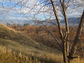
Okanagan Mountain Provincial Park is a provincial park within the Okanagan-Similkameen Regional District of British Columbia, Canada, focused on the mountain of the same name and located on the east side of Okanagan Lake, opposite Peachland and immediately south of the City of Kelowna. The park is one of the largest in the area, covering 110.38 square kilometres (42.62 sq mi). Most of the park is only accessible by foot, horseback, bicycle, or boat as motor vehicle access is restricted to BC Parks staff and technicians servicing the three telecommunications towers in the park.

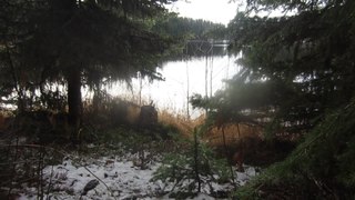
Browne Lake Provincial Park is a provincial park in British Columbia, Canada, located 22 km east-southeast of Kelowna in the Okanagan Highland, near Big White Ski Resort and between the heads of Hydraulic and Grouse Creeks.

Cathedral Provincial Park and Protected Area, usually known as Cathedral Provincial Park and also as Cathedral Park, is a provincial park in British Columbia, Canada. It is located east of E.C. Manning Provincial Park, south of BC Highway 3, and southeast of the town of Princeton, and southwest of Keremeos. Its southern boundary is the border with the United States. Much of the park is the basin of the Ashnola River. Cathedral Park is home to teal sub-alpine lakes, vast ridges and jarred peaks, old-growth forests, and rock formations of siltstone, granodiorite, and basalt. Hikers can scramble along various peaks such as the 8000-foot Grimface Mountain and Lakeview Mountain. Tourists flock to Smokey the Bear and Stone City because of their unique formations with incredible views formed by millennia of erosion, volcanic and tectonic activity, and glacial recession.
ȽÁU,WELṈEW̱/John Dean Provincial Park, formerly John Dean Provincial Park, is a small, densely vegetated provincial park on the Saanich Peninsula of southern Vancouver Island, British Columbia, Canada. The park is located on and around ȽÁU,WELṈEW̱, a small mountain in the traditional territory of Wsanec First Nations, itself situated 20 km north of Victoria, the provincial capital city.

MacMillan Provincial Park is a 301-hectare (740-acre) provincial park in British Columbia, Canada. Located 25 km (16 mi) west of Qualicum Beach and 16 km (9.9 mi) east of Port Alberni, the park straddles Highway 4 and the Island Rail Corridor in central Vancouver Island. It is nestled on the western shore of Cameron Lake, and protects the delta of the Cameron River. The park is home to a famous, 157-hectare (390-acre) stand of ancient Douglas fir, known as Cathedral Grove, which draws visitors from all over the world. The park provides the only highway-accessible protected old-growth Douglas-fir forest in British Columbia. In 2007 Cathedral Grove made the short list on CBC's competition Seven Wonders of Canada.

Myra-Bellevue Provincial Park is a provincial park in British Columbia, Canada, located in the Okanagan Highland east of Kelowna. It was established to protect the full elevational range of the North Okanagan Basin and North Okanagan Highlands ecosections.
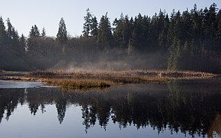
Okanagan Lake Provincial Park is a provincial park in British Columbia, Canada. Established in 1955, the park covers a total area of 98 hectares.
Upper Seymour River Provincial Park is a provincial park in British Columbia, Canada. Located in an isolated area in the interior of the province, 40 kilometres north of the community of Seymour Arm. It protects at the headwaters of the Seymour River, which is the major drainage system into the Seymour Arm of Shuswap Lake.
Schoen Lake Provincial Park is a provincial park in northeastern Vancouver Island, British Columbia, Canada, located east of the community of Woss Lake and southwest of Sayward. The park lies inside the Nimpkish Valley watershed. On October 28, 1977, the "Class A" park was officially created to protect, exhibit and interpret an example of the natural features and processes of the Insular Mountains Natural Region. The park covers a total area of 8,775 hectares. Within those hectares of park land is a number of lakes, creeks and mountain ranges.
Tweedsmuir South Provincial Park is a provincial park covering parts of the eastern Kitimat Ranges, northern Pacific Ranges, and the Rainbow Range in British Columbia, Canada. It was established on May 21, 1938 in the western interior of the province, to protect its important natural features. The park hosts a variety of recreation activities for visitors. This park encompasses a range of diverse species in this park including bears, moose, and various fish. There are also a few at risk species in this park.
The Okanagan Highland is an elevated hilly plateau area in British Columbia, Canada, and the U.S. state of Washington. Rounded mountains with elevations up to 8,000 ft (2,400 m) above sea level and deep, narrow valleys are characteristic of the region.

Vaseux Lake is a shallow freshwater lake located along the course of the Okanagan River in the Okanagan Valley of British Columbia, Canada.

The Cascade Mountains leeward forests are a temperate coniferous forest ecoregion of North America, as defined by the World Wildlife Fund (WWF) categorization system.

Lac du Bois Grasslands Protected Area is a protected area located north of Kamloops in British Columbia, Canada. The protected area was established by BC Parks on 30 April 1996 to protect a unique mixed forest-grassland ecosystem overlooking the North and South forks of the Thompson River.

South Chilcotin Mountains Provincial Park is a provincial park in British Columbia, Canada, located on Highway 40 northwest of Lillooet, British Columbia. The park, which is 56,796 ha. in size, was established on April 18, 2001, and It was created out of a portion of the Spruce Lake Protected Area. The park is located on three Indigenous Nations: The Tsilhqot’in, St’at’imc, and Secwepemc.
Vaseux-Bighorn National Wildlife Area is a National Wildlife Area in British Columbia, Canada, primarily set aside to protect winter rangeland for California bighorn sheep. In 1979, the Vaseux-Bighorn Wildlife Area was established in response to substantial reduction in wild animal populations in the area. Identified factors contributing to species decline at the time were high predator population, overharvesting of species, and illegal hunting. Land development, cattle raising, and lumbering also might have altered species populations. Under these conditions, the area was able to be classified as a Category IV area by the IUCN and is now used for wildlife habitat and conservation. Even with minimal anthropogenic use of the area, threats persist through invasive species. Recreational use is limited spatially and is only open to the public during the day.
Puget lowland forests is a temperate coniferous forest ecoregion on the Pacific coast of North America, as defined by the World Wildlife Fund (WWF) categorization system.

Okanagan dry forests is a temperate coniferous forest ecoregion in the Pacific Northwest of North America, as defined by the World Wildlife Fund (WWF) categorization system. It is closely associated with the Okanagan region of British Columbia and Washington. Only 20% of the ecosystem is still intact, and continues to be under threat for preservation due to land clearing and urban expansion, alongside the increasing threats of fire and extreme weather due to climate change.
Todagin Wildlife Management Area is a wildlife management area located southeast of Iskut in northwestern British Columbia. It was established by the British Columbia Ministry of Forests, Lands, Natural Resource Operations and Rural Development (FLNRORD) on 19 March 2001 to conserve and manage critical habitat for stone sheep. It is the largest wildlife management area in British Columbia at 122,787 ha.

