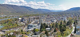
Kamloops is a city in south-central British Columbia, Canada, at the confluence of the North and South Thompson Rivers, which join to become the Thompson River in Kamloops, and east of Kamloops Lake. It is located in the Thompson-Nicola Regional District, whose district offices are based here. The surrounding region is sometimes referred to as the Thompson Country.

Clearwater is a district municipality in the North Thompson River valley in British Columbia, Canada, where the Clearwater River empties into the North Thompson River. It is located 124 km (77 mi) north of Kamloops. The District of Clearwater was established on December 3, 2007, making it one of the newest municipalities in British Columbia. It is near Wells Gray Provincial Park and is surrounded by the Trophy Mountains, Raft Mountain and Dunn Peak.
The Bonaparte Plateau, in British Columbia, Canada, is a sub-plateau of the Thompson Plateau which extends to the Quesnel River and lies between the Cariboo Mountains on the east and the Fraser River on the west. The Thompson Plateau is itself a sub-plateau of the larger Fraser Plateau.

Adams Lake Provincial Park is a provincial park in British Columbia, Canada. It encompasses three distinct parks: Adams Lake Provincial Park, Adams Lake Marine Provincial Park, and Adams Lake Marine Provincial Park.
Bonaparte Provincial Park is an 11,811 hectare provincial park in British Columbia, Canada. It is located within the Bonaparte Plateau.

Caligata Lake Provincial Park is a provincial park in British Columbia, Canada, located northeast of Clearwater. The lake occupies a cirque below the north face of Raft Mountain. The park has no visitor facilities or services.
Harbour Dudgeon Lakes Provincial Park is a provincial park in British Columbia, Canada, located west of the Adams River, northwest of Celista Mountain. It was established on April 30, 1996. The park is located approximately 175 km northeast of Kamloops.
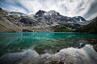
Joffre Lakes Provincial Park is a class A provincial park located 35 kilometres (22 mi) east of Pemberton in British Columbia, Canada. It was established in 1996, when Joffre Lakes Recreation Area was upgraded to park status.
Monte Creek Provincial Park is a provincial park in British Columbia, Canada, located in the locality of Monte Creek, British Columbia. Created in 1996, it is only 3 hectares in size, and protects a forested riparian area and also quiggly hole ("kekuli") sites of the Shuswap people, which have been formally studied as an archaeological site. The location was also part of the route of the Hudson's Bay Brigade Trail to the Cariboo via Kamloops from what is now the United States, as was Monte Lake in the upper basin of the eponymous creek.
Mud Lake Delta Provincial Park is a provincial park in British Columbia, Canada, located in the North Thompson Country due east of Blue River, 230 km from Kamloops on BC Highway 5.

Paul Lake Provincial Park is a provincial park in British Columbia, Canada, located southwest of Heffley Lake and to the northeast of the city of Kamloops.
Porcupine Meadows Provincial Park is a 2,704 hectare provincial park in British Columbia, Canada, located north of Tranquille Lake to the northwest of Kamloops. Its name is a direct translation of the Shuswap word for this area, "pisitsoolsia", named so for the numerous porcupine in the area.
Roche Lake Provincial Park is a provincial park in British Columbia, Canada, located northeast of Stump Lake in the Nicola Country of that province's South-Central Interior. The park lies to the northwest of the city of Merritt and to the south of Kamloops.

Tsútswecw Provincial Park is a provincial park in British Columbia, Canada, located northeast of Kamloops and northwest of Salmon Arm. It stretches along the banks of the Adams River, between the south end of Adams Lake and the western portion of Shuswap Lake.

Shuswap Lake Provincial Park is a provincial park in British Columbia, Canada. It is located in the community of Scotch Creek, on the north shore of the main arm of Shuswap Lake in the Southern Interior of BC. The park is about 45 minutes north of Salmon Arm, and about 1 hour east of Kamloops. The park contains a large campground with approximately 275 camping sites, as well as a large sand and gravel beach and day use/picnic area. It is a very popular park, with many thousands of people, primarily from BC and Alberta, camping there every year.

The Deadman River, also known as the Deadman's River, Deadman Creek or Deadman's Creek, is a tributary of the Thompson River in the British Columbia Interior of British Columbia, Canada. It is about 70 kilometres (43 mi) in length.
Bridge Lake is a lake in the Interlakes District of the South Cariboo region of the Interior of British Columbia, Canada. It is the source of Bridge Creek which runs in a curving course west and then northeast to Canim Lake via the town of 100 Mile House. The lake is approximately 16 km2 in area (including the area of several islands and rocks in the lake, the largest of which is named Long Island and is 1136 m in elevation. It is located 560 km north of Vancouver and around 140 km northwest of Kamloops in the Interlakes District close to the Little Fort Highway. It and its neighbours Sheridan Lake and Lac des Roches are the largest lakes along the Interlakes Highway.

Terry Lake is a former Canadian politician, at the municipal and provincial levels, and veterinarian.

Mount Hugh Neave is a mountain in east-central British Columbia, Canada, located between Hobson Lake to the west and Goat Creek to the south. Situated in the Cariboo Mountains of the Columbia Mountains, it is the seventh highest mountain in Wells Gray Provincial Park with an elevation of 2,829 m (9,281 ft).

Lac du Bois Grasslands Protected Area is a protected area located north of Kamloops in British Columbia, Canada. The protected area was established by BC Parks on 30 April 1996 to protect a unique mixed forest-grassland ecosystem overlooking the North and South forks of the Thompson River.

