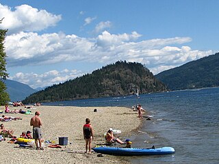
Adams Lake Provincial Park is a provincial park in British Columbia, Canada. It encompasses three distinct parks: Adams Lake Provincial Park, Adams Lake Marine Provincial Park, and Adams Lake Marine Provincial Park.

Boundary Creek Provincial Park is a provincial park in British Columbia, Canada located south of Greenwood BC in that province's Boundary Country, adjacent to BC Highway 3. The eponymous Boundary Creek flows through the park.

Big Creek Provincial Park is a provincial park in British Columbia, Canada.

Eneas Lakes Provincial Park is a provincial park in British Columbia, Canada, located west of the town of Peachland, to the south of Peachland Creek. The park is approximately 1036 ha. in size and was established in 1968. The Eneas Lakes lie at the head of Finlay Creek.

Finn Creek Provincial Park is a provincial park in British Columbia, Canada, north of Avola and Blue River in the valley of the North Thompson River.

Harbour Dudgeon Lakes Provincial Park is a provincial park in British Columbia, Canada, located west of the Adams River, northwest of Celista Mountain. It was established on April 30, 1996. The park is located approximately 175 km northeast of Kamloops.

Johnstone Creek Provincial Park is a provincial park in British Columbia, Canada, located west of the confluence of Rock Creek and the Kettle River and the town of Rock Creek. The park has a roughly 38 hectare area, and is near to the Crowsnest Highway.

Momich Lakes Provincial Park is a provincial park in British Columbia, Canada, located at the north end of Adams Lake 100km northeast of Kamloops.

Monte Creek Provincial Park is a provincial park in British Columbia, Canada, located in the locality of Monte Creek, British Columbia. Created in 1996, it is only 3 hectares in size, and protects a treed river riparian area and also quiggly hole ("kekuli") sites of the Shuswap people, which have been formally studied as an archaeological site. The location was also part of the route of the Hudson's Bay Brigade Trail to the Cariboo via Kamloops from what is now the United States, as was also Monte Lake in the upper basin of the eponymous creek.

Monte Lake Provincial Park is a provincial park in British Columbia, Canada, located on the east side of Monte Lake and to the south of the community of Monte Lake, British Columbia which is at the north end of the lake. About five hectares in size, it protects an area of Ponderosa pine and grasslands.

Nuntsi Provincial Park, also known as Taseko Provincial Park, is a provincial park in British Columbia, Canada, located on the west side of the Taseko River in that province's Chilcotin District, flanking both sides of Nuntsi Creek.

Upper Adams River Provincial Park is a provincial park in British Columbia, Canada.

Upper Violet Creek Provincial Park is a provincial park in British Columbia, Canada.

Pritchard Provincial Park is a provincial park in British Columbia, Canada, located on the north side of the South Thompson River between the communities of Monte Creek (W) and Chase (E). The Park is actually split into two sections. The best access to the actual Park is from the water; as you would need Private Land owners permission to access from the land. The area in between the Park's boundaries is supposedly under the Province of British Columbia's jurisdiction, but is not part of the Provincial Park itself.

Pukeashun Provincial Park is a provincial park in British Columbia, Canada, located north of the community of Scotch Creek, near the city of Salmon Arm. The park is named for Pukeashun Mountain which is within its boundaries and a major local landmark. It protects part of the Adams Plateau, the southeastern portion of the Shuswap Highland.
Pyramid Creek Falls Provincial Park is a provincial park in British Columbia, Canada, located on the east side of the North Thompson River between the towns of Blue River (S) and Valemount (N).

Shuswap Lake Provincial Park is a provincial park in British Columbia, Canada.

Shuswap Lake Marine Provincial Park is a provincial park in British Columbia, Canada, comprising 894 ha. The Park has a variety of amenities including boat launch ramps, picnic areas, and 27 campsites around the perimeter of Shuswap Lake. The lake's name and that of the surrounding Shuswap Country is from the Shuswap people (Secwepemc), the most northern of the Salishan speaking people.

French Bar Creek Provincial Park is a provincial park in British Columbia, Canada, located 60 kilometres north of Lillooet, British Columbia. The park, which is 1159 ha. in size, was established in 2010.
Inkaneep is an unincorporated community located on the east side of the Okanagan River within Osoyoos Indian Reserve No. 1, between the towns of Oliver and Osoyoos, British Columbia, Canada, in that province's South Okanagan region.


