
Northern Manitoba is a geographic and cultural region of the Canadian province of Manitoba. Originally encompassing a small square around the Red River Colony, the province was extended north to the 60th parallel in 1912. The region's specific boundaries vary, as "northern" communities are considered to share certain social and geographic characteristics, regardless of latitude.
Babine Lake Marine Park is on Babine Lake, which borders the Skeena and Omineca regions of central British Columbia. This provincial park comprises six separate sites around the lake. Vehicle access to the lake, via BC Highway 16 and Nilkitkwa forestry service road, is by road about 105 kilometres (65 mi) northeast of Smithers; via BC Highway 16 and Central Babine Lake Highway, is about 132 kilometres (82 mi) east of Smithers; or via Babine Lake Road, is about 20 kilometres (12 mi) northeast of Burns Lake.
Burns Lake Park is a provincial park in British Columbia, Canada, located near the town of Burns Lake. The park was established per Order in Council 63 on January 25, 2001, and constitutes approximately 65 hectares.
Ed Bird – Estella Lakes Provincial Park is a provincial park in British Columbia, Canada.
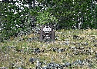
Octopus Islands Marine Provincial Park is a provincial park in British Columbia, Canada. It is located between Quadra Island and Maurelle Island in Okisollo Channel.
Morton Lake Provincial Park is a provincial park in British Columbia, Canada, located on Vancouver Island northwest of the city of Campbell River.
Mount Blanchet Provincial Park is a provincial park in British Columbia, Canada, located on the west side of the southern end of Takla Lake, north of Smithers.
Nation Lakes Provincial Park is a provincial park in British Columbia, Canada.
Uncha Mountain Red Hills Provincial Park is a provincial park in British Columbia, Canada, comprising two parcels of land on the north and south shores of Francois Lake. Total area of the park is 9,421 hectares.
Wapiti Lake Provincial Park is a 16,837-hectare (41,610-acre) provincial park in British Columbia, Canada. It is 60 kilometres (37 mi) south of Tumbler Ridge, at the headwaters of Wapiti River, including its watershed from the Wapiti Pass to Wapiti Lake in the Canadian Rockies. The area contains significant amounts of fossils (ichthyosaurs) and fossil beds. There is habitat for grizzly bears, mountain goats, and bull trout. It was established as a Provincial Park on June 26, 2000. It is recognized by the provincial government as being an area traditionally used by First Nations people. Hunting and fishing are permitted in the park.
Read Island Provincial Park is a provincial park in British Columbia, Canada. It is located on the south end of Read Island. Established in 1996, the park contains approximately 637 ha.
Rubyrock Lake Provincial Park is a provincial park in British Columbia, Canada. More information on the park can be found on the BC Parks website.
Stuart Lake Marine Provincial Park is a provincial park in British Columbia, Canada.
Sutherland River Provincial Park and Protected Area is a provincial park in British Columbia, Canada.
Thurston Bay Marine Provincial Park is a provincial park on the northwest side of Sonora Island in British Columbia, Canada.
Taylor Arm Provincial Park is a provincial park in British Columbia, Canada, located on the north side of Sproat Lake 23 km northwest of Port Alberni on Vancouver Island. Situated along Highway 4, the 71-hectare park has few services but provides group camping sites, undeveloped beaches, and day-use areas. The group camping site has pit toilets and a hand pump water supply, and is connected to the lake shore via a trail that passes under the highway.
Trembleur Lake Provincial Park is a provincial park in British Columbia, Canada.
Tranquil Creek Provincial Park is a provincial park in British Columbia, Canada, located at the head of the Kennedy River, east of the head of Bedwell Sound on Vancouver Island.
Wilson Park or variant, may refer to:
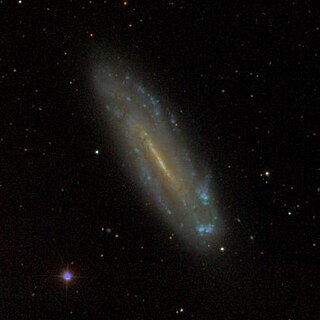
NGC 4178 is the New General Catalogue identifier for a barred spiral galaxy in the equatorial constellation of Virgo. It was discovered April 11, 1825 by English astronomer John Herschel. Located some 43.8 million light years away, this galaxy spans 2.3 × 0.4 arc minutes and is seen at a low angle, being inclined by 77° to the line of sight from the Earth. The morphological classification of NGC 4178 is SB(rs)dm, indicating that it has a bar feature at the core, and, per the '(rs)', has traces of a ring-like structure surrounding the bar. The 'dm' suffix indicates the spiral arms are diffuse, broken, and irregular in appearance with no bulge at the nucleus. This galaxy is a member of the Virgo Cluster, which is the richest nearby group of galaxies outside the Local Group and forms the core of the Virgo Supercluster.
