
The Musqueam Indian Band is a First Nations band government in the Canadian province of British Columbia. It is the only First Nations band whose reserve community lies within the boundaries of the City of Vancouver.
Arrow Lakes Provincial Park is a provincial park in British Columbia, Canada.
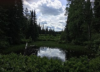
Babine Lake Marine Provincial Park is a provincial park in British Columbia, Canada. The park was established by Order-in-Council in 1993, comprising two sites at Pendleton Bay totalling 36.9 hectares. Another was established in the same year at Smithers Landing, comprising approximately 157.8 hectares. Three more sites were added in 2001, Hook (Deep) Bay, Pierre Creek, Pinkut Creek and Sandpoint. All sites combined comprise approximately 492 hectares.

Cathedral Provincial Park and Protected Area, usually known as Cathedral Provincial Park and also as Cathedral Park, is a provincial park in British Columbia, Canada. It is located east of E.C. Manning Provincial Park, south of BC Highway 3, and southeast of the town of Princeton, and southwest of Keremeos. Its southern boundary is the border with the United States. Much of the park is the basin of the Ashnola River. Cathedral Park is home to teal sub-alpine lakes, vast ridges and jarred peaks, old-growth forests, and rock formations of siltstone, granodiorite, and basalt. Hikers can scramble along various peaks such as the 8000-foot Grimface Mountain and Lakeview Mountain. Tourists flock to Smokey the Bear and Stone City because of their unique formations with incredible views formed by millennia of erosion, volcanic and tectonic activity, and glacial recession.
Cornwall Hills Provincial Park is a provincial park in British Columbia, Canada, immediately west of Cache Creek, protecting part of the Cornwall Hills including their highest summit which features an old fire lookout.
Christina Lake Provincial Park is a provincial park in British Columbia, Canada. The lake it's on, Christina Lake, is renowned as the warmest lake in Canada.
Eskers Provincial Park is a provincial park in British Columbia, Canada. The park comprises roughly 4,044 hectares and was created in 1987. Located west of Nukko Lake, which lies northwest of the city of Prince George, it protects an area of the 40-kilometre (25 mi) Stuart River Eskers Complex. Eskers are winding ridges of gravel formed by the glaciers which once covered the British Columbia Interior.

Fossli Provincial Park is a provincial park in British Columbia, Canada, located on Stirling Arm of Sproat Lake on Vancouver Island. The 52-hectare park, west of Port Alberni, is accessible by water or private logging road. It has few services, but has a 30-minute hiking trail to an old homestead site. The homestead belonged to Helen and Armour Ford, who donated the land for the park to the province in 1974. Saint Andrew's Creek runs through the park, and is a fall spawning ground for coho salmon.
Granby Provincial Park is a provincial park in British Columbia, Canada. It is located north of Grand Forks and contains the northern portion of the Granby River. The park is 411.56 km2 in size.
Kingfisher Creek Provincial Park is a provincial park in British Columbia, Canada located 15 km southeast of Sicamous and west of Mabel Lake in the Monashee Mountains. The park is 440 hectares and was created to enhance the viability of the Kingfisher Creek Ecological Preserve.
Pritchard Provincial Park is a provincial park in British Columbia, Canada, located on the north side of the South Thompson River between the communities of Monte Creek (W) and Chase (E). The Park is actually split into two sections. The best access to the actual Park is from the water; as you would need Private Land owners permission to access from the land. The area in between the Park's boundaries is supposedly under the Province of British Columbia's jurisdiction, but is not part of the Provincial Park itself.
Roberts Creek Provincial Park is a provincial park in British Columbia, Canada, located northwest of the community of Roberts Creek, between Gibsons and Sechelt. First created in 1947 with an area of 100 acres (0.40 km2), it was modified in size in 2000 to approximately 40 ha.
Syringa Park is a provincial park on the east shore of Lower Arrow Lake in the West Kootenay region of southeastern British Columbia. At the foot of the Norns Range, Tulip Creek passes through the centre, and Syringa Creek is closer to the southeastern boundary. The park is about 19 kilometres (12 mi) west of Castlegar via Broadwater Rd.

Tetrahedron Provincial Park is a provincial park located within the territory of the shíshálh Nation on the southern Sunshine Coast, in British Columbia, Canada. The park was created in 1995 thanks to the efforts of a collective of NGOs who came together to protect the headwaters of the Chapman Creek and Gray Creek Community Watersheds from commercial logging activities.
The Upper Similkameen Indian Band or Upper Smelqmix, is a First Nations band government in the Canadian province of British Columbia, whose head offices are located in town of Hedley in the Similkameen Country. They are a member of the Okanagan Nation Alliance.
Agamemnon Channel is a channel or strait in British Columbia, Canada, at the mouth of Jervis Inlet on the South Coast, separating Nelson Island from the mainland of the Sunshine Coast. The ferry terminal and recreational community of Earls Cove is on its mainland side.
Tyoax Pass is a mountain pass in the Chilcotin Ranges of the Pacific Ranges, the southernmost main subdivision of the Coast Mountains of British Columbia, Canada. Located at the head of Tyaughton Creek, a north tributary of the Bridge River, it connects the basin of the Bridge River with that of Big Creek in the southern Chilcotin District, and is therefore at the boundary between the Spruce Lake Protected Area and Big Creek Provincial Park.
Tonquin Pass, 1948 m (6393 ft), is a mountain pass in the Canadian Rockies, linking Tonquin Valley in Jasper National Park, Alberta, to Mount Robson Provincial Park and adjoining areas of British Columbia. It is at the headwaters of Tonquin Creek, which flows into British Columbia. Located on the interprovincial boundary, it is on the Continental Divide.
Boundary Creek is a tributary of the Kettle River in the Boundary Country region of south central British Columbia. The creek is approximately 32 kilometres (20 mi) in length, flowing from the northeast, passing east of Midway, and only the final one-quarter mile (0.40 km) is in northeastern Washington, US.
Theodosia Arm is a locality in the Desolation Sound area of the South Coast region of British Columbia, Canada, located at the head of Thors Cove, an arm of Malaspina Inlet, near the outlet of Theodosia Inlet.
