Mount Tzouhalem

Last updated
Mount Tzouhalem
Mount Tzouhalem.jpg
Summit of Mount Tzouhalem
Highest point
Elevation 536 m (1,759 ft) [1]
Coordinates 48°46′42″N123°36′52″W / 48.77833°N 123.61444°W / 48.77833; -123.61444 Coordinates: 48°46′42″N123°36′52″W / 48.77833°N 123.61444°W / 48.77833; -123.61444 [2]
Geography
Canada British Columbia relief location map.jpg
Red triangle with thick white border.svg
Mount Tzouhalem
Location in western British Columbia
Location Vancouver Island, British Columbia, Canada
DistrictCowichan Land District
Topo map NTS   92B13 Duncan

Mount Tzouhalem is a mountain on Vancouver Island, British Columbia, Canada, 4 kilometres east-northeast of Duncan [3] in the municipality of North Cowichan. It is situated between Quamichan Lake, Maple Bay and Cowichan Bay.

Contents

The mountain is part of the municipal forest lands. Part of the mountain is an 18-hectare ecological reserve. It is popular with hikers and mountain bikers. It gives views towards Saltspring Island, the Coastal Mountains of the Lower Mainland and, on a clear day, Mount Baker in Washington state.

There was a large Christian cross on one cliffside. The original wooden cross, placed by local Catholic churches in the 1970s, was replaced by the Knights of Columbus with a welded version in the late 1980s. [4] In the night from July 16th to July 17th 2021, unknown individuals removed the cross for unknown reasons. [5]

Naming

The mountain was originally named "Shkewetsen" (meaning "basking" or "warming in the sun") by the local First Nations. [3] According to legend, the local inhabitants fled to the mountain to escape the rising waters of a great flood. When the waters subsided, a frog was seen warming itself in the sun on a large rock on the side of the mountain. The frog rock formation was called "Pip'oom" (meaning "little swelled-up one"). [6]

The mountain was renamed after a preeminent Quamichan chief who lived his final years on the side of the mountain after being banished by his own people.

Born of a Quamichan man and a Comiaken woman, Tzouhalem was trained to be a warrior by his grandmother. [7] He was infamous for his combative and unruly behaviour. His fighting prowess probably helped establish Quamichan as the largest and wealthiest of the Cowichan villages. [7]

In addition to defeating northern invaders near Maple Bay, in part by disguising warriors in canoes as women, [4] Tzouhalem assumed command of the First Nations attacking Fort Victoria in 1844. Enraged by the fort's demands for compensation or punishment following the slaying of some ranging cattle, Tzouhalem's warriors peppered the fort with threats and musket balls for two days until its Chief Factor Roderick Finlayson arranged for demonstrations of the fort's nine-inch cannons. After the cannons destroyed a cedar-bark hut and a canoe, the parties negotiated compensation to resolve the dispute and Tzouhalem withdrew his forces. [8]

Because of his frequent murders, Tzouhalem was at last banished by his fellow tribesmen, and took up residence in a cave on the side of Mount Tzouhalem. He had fourteen wives living with him, most of whom had been widowed by him. In 1859, when trying to gain another wife from Penelakut Island (Kuper Island until 2010), he was killed by her or her husband. [9]

The mountain served as the target for the cannons of HMS Trincomalee of the Royal Navy's Pacific Squadron when it signalled its arrival in Cowichan Bay. [10] Early maps by the British identified the area as "Tzohailim Hill" (1855) and "Tzohailin Hill" (1864). In 1911, the Geographical Names Board of Canada adopted "Tzuhalem Mountain". In 1950, the form of name changed to "Mount Tzuhalem" until the spelling was altered to Mount Tzouhalem in 2000 to align with the local, traditional spelling supported by the Cowichan Tribes band government. [2]

Ecological Reserve

After the Cowichan Valley Naturalists' Society encountered signs in 1979 that a housing subdivision was planned for the area, they successfully lobbied the municipal council and Mayor Graham Bruce to preserve the land. North Cowichan donated the municipally owned land to BC Parks in 1980. [6]

In 1984, BC Parks created the 18-hectare Mount Tzuhalem Ecological Reserve to preserve outstanding Garry oak-wildflower stands. Ecological Reserves are areas in British Columbia selected to preserve representative and special natural ecosystems, plant and animal species, features, and phenomena. Ecological Reserves provide the highest level of protection for the maintenance of physical and biological diversity, while allowing for research and educational activities.

The reserve, at middle elevations (120–280 metres) on the western side of the mountain, faces southwest and has strongly sloping, internally hilly terrain. [11] The Tzuhalem area is a historical harvesting location for the Vancouver Island Coast Salish First Nations. The reserve is a camas harvesting site that was traditionally burned to increase yields and maintain the open, park-like habitat. [11]

Access

Easiest access is from a parking lot at the head of Kaspa Road (~ 30 spaces). The mountain can also be reached from Genoa Bay (most difficult ascent). Trails are open year-round, except during periods of high fire hazard, for non-vehicular traffic. [3]

Related Research Articles

<span class="mw-page-title-main">Duncan, British Columbia</span> City in British Columbia, Canada

Duncan is a city on southern Vancouver Island in British Columbia, Canada. It is the smallest city by area in Canada. It was incorporated in 1912.

<span class="mw-page-title-main">North Cowichan</span> District municipality in British Columbia, Canada

North Cowichan is a district municipality established in 1873 on Vancouver Island, in British Columbia, Canada. The municipality is part of the Cowichan Valley Regional District. North Cowichan is noted for a landscape including forests, beaches, rivers, and lakes. The municipality encompasses the communities of Chemainus; Westholme; Crofton; Maple Bay; and "the South End". The latter is an informal name for a built-up area which is essentially a suburb of the City of Duncan, a separate municipality.

<span class="mw-page-title-main">Fort Victoria (British Columbia)</span>

Fort Victoria began as a fur trading post of the Hudson’s Bay Company and was the headquarters of HBC operations in the Columbia District, a large fur trading area now part of the province of British Columbia, Canada and the U.S. state of Washington. Construction of Fort Victoria in 1843 highlighted the beginning of a permanent British settlement now known as Victoria, the capital city of British Columbia. The fort itself was demolished in November 1864 as the town continued to grow as a commercial centre serving the local area as well as trading with California, Washington Territory, the United Kingdom, and others.

<span class="mw-page-title-main">Burgoyne Bay</span>

Burgoyne Bay is located at the southern end of Saltspring Island in British Columbia, Canada. The shores of the bay are part of the Mount Maxwell Ecological Reserve. The bay branches off from Sansum Narrows, which separates Saltspring from Vancouver Island.

<span class="mw-page-title-main">Quamichan</span>

Quamichan is a traditional nation of the Coast Salish people, commonly referred to by the English adaptation of Qu'wutsun as the Cowichan Indians, or First Nations, of the Cowichan Valley on Vancouver Island, in the area near the city of Duncan, British Columbia.

<span class="mw-page-title-main">Mount Maxwell Provincial Park</span> Provincial park in British Columbia, Canada

Mount Maxwell Provincial Park is a provincial park in the Gulf Islands of British Columbia, Canada. It is located on Burgoyne Bay and the Sansum Narrows on the western shores of Saltspring Island.

Maple Bay is a seaside community located in the Cowichan Valley of southern Vancouver Island, British Columbia, Canada. A narrow inlet and surrounded by smooth, pebbled beaches, Maple Bay is home to marine activity all year round. Maple Bay is a small town with a population of 2,640.

William Henry McNeill was best known for his 1830 expedition as the captain of the brig Llama, which sailed from Boston, Massachusetts, United States, 12,000 miles (19,000 km) around Cape Horn, to the Pacific Northwest on a maritime fur trade expedition.

<span class="mw-page-title-main">Cowichan Tribes</span> Place in Canada

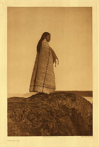
Cowichan Tribes is the band government of the Cowichan, a group of Coast Salish peoples who live in the Cowichan Valley region on Vancouver Island. With over 3,800 registered members, it is the single largest First Nations band in British Columbia.

<span class="mw-page-title-main">Roderick Finlayson</span>

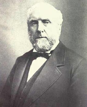
Roderick Finlayson was a Canadian Hudson's Bay Company officer, farmer, businessman, and politician.

Robson Bight is a small Vancouver Island bay at the west end of Johnstone Strait across from West Cracroft Island in British Columbia, Canada that includes a protected killer whale habitat famous for its whale-rubbing beaches. The bight is adjacent to Lower Tsitika River Provincial Park. The nearest access point is Telegraph Cove on the east coast of Northern Vancouver Island.

<span class="mw-page-title-main">Portland Island (British Columbia)</span>

Portland Island is an island of the Southern Gulf Islands of the South Coast of British Columbia, Canada. It is located in the Salish Sea west of Moresby Island and off the south tip of Saltspring Island, adjacent to the main BC Ferries route just offshore from the terminal at Swartz Bay at the tip of the Saanich Peninsula. It was named after HMS Portland, the flagship of Rear-Admiral Fairfax Moresby, Commander in Chief of the Pacific Station 1850–1853.

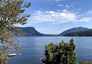
Sansum Narrows is a strait or channel between Vancouver Island (W) and Saltspring Island (E) in the Southern Gulf Islands region of British Columbia, Canada. The sqtheq, or narrows in English, lies in the unceeded traditional territory of the Quw'utsun (Cowichan) people, between Hwtl’upnets and Tl’ulpalus. Traditionally, Sansum Narrows was the home of Sheshuq'um, a creature renowned for eating travellers, leaving only shattered canoes behind. Until Smakw'uts, a legendary strongman, killed Sheshuq'um, the sqtheq was considered untraversable.

Vesuvius, also known as Vesuvius Bay, is an unincorporated settlement and ferry terminal on the northwest coast of Saltspring Island in the Gulf Islands of British Columbia, Canada. It is the eastern terminus of a ferry which connects Saltspring Island to Vancouver Island across Sansum Narrows to Crofton, which is just north of the city of Duncan.

<span class="mw-page-title-main">Chatham Islands (British Columbia)</span> Place in British Columbia, Canada

The Chatham Islands are a group of islands off the east coast of Oak Bay, British Columbia, Canada. All the islands are in Chatham Islands Indian Reserve No. 4, under the control of the Songhees First Nation. The island foreshore, defined as the land between low tide and the beginning of land-based vegetation, is provincial Crown land.

<span class="mw-page-title-main">Hwlitsum First Nation</span>

The Hwlitsum First Nation is an organization representing the group historically known as the Lamalchi or Lamalcha but properly called Hwlitsum. The Hwlitsum are the descendants of the Lamalchi people and changed their name to Hwlitsum when they moved to Hwlitsum in 1892. Hul'qumi'num custom names groups based on the location of their winter village. Changing location of their winter village changed the name of the people. The Hwlitsum are a Hulquminum-speaking people whose home region is in the Southern Gulf Islands. The Hwlitsum were never granted reserves or band status and are currently seeking recognition as a band government from the governments of British Columbia and Canada.

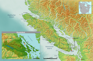
Stuart Channel is a strait in the Gulf Islands region of the Gulf of Georgia, separating Vancouver Island on the west from Thetis, DeCourcy and Penelakut (Kuper) Islands on the east. Ladysmith Harbour and the town of Chemainus face onto it from Vancouver Island. It is crossed by a BC Ferries route serving Thetis and Penelakut Islands.

<span class="mw-page-title-main">Quamichan Lake</span> Lake in British Columbia, Canada

Quamichan Lake is a lake in the Cowichan Valley region of Vancouver Island, British Columbia, Canada, located three kilometres to the northeast of the City of Duncan.

An electoral redistribution in British Columbia was undertaken by the BC Electoral Boundaries Commission beginning in 2014 and was formalized by the passage of Bill 42, the 2015 Electoral Districts Act, during the 40th British Columbia Parliament. The act came into effect on November 17, 2015. The redistribution added two seats to the previous total, increasing the number of MLAs in the province from 85 to 87. The electoral boundaries came into effect for the 2017 election. The next redistribution is required to occur following the 2020 British Columbia general election.

References

  1. "Maple Bay". Travel British Columbia. Archived from the original on 24 June 2013. Retrieved 23 June 2013.
  2. 1 2 "Mount Tzouhalem". BC Geographical Names . Retrieved 2013-06-15.
  3. 1 2 3 Guide to Mount Tzouhalem (PDF). Municipality of North Cowichan.
  4. 1 2 "Mount Tzouhalem". Nanaimo Information. Archived from the original on 29 March 2006. Retrieved 15 June 2013.
  5. Rothbauer, Kevin (2021-07-17). "Cross that overlooked Cowichan Valley from Mount Tzouhalem cut down". Cowichan Valley Citizen. Retrieved 2021-07-30.
  6. 1 2 Elms, Lindsay. Beyond Nootka: A Historical Perspective of Vancouver Island Mountains. Misthorn Press. ISBN   0968015905.
  7. 1 2 Arnett, Chris. "An introduction to First Nations' history in the Gulf Islands". Saltspring Archives. Retrieved 12 June 2013.
  8. "Author Profile: Roderick Finlayson". ABC Bookworld. Retrieved 12 June 2013.
  9. Akrigg, Helen B. and Akrigg, G.P.V; British Columbia Place Names; Sono Nis Press, Victoria 1986 /or University of British Columbia Press 1997
  10. Wagner, Thomas (2004). Cowichan Bay From 1850 to now…. ISBN   0-9732168-0-8.
  11. 1 2 "Detailed Description - Mount Tzuhalem ER" (PDF). Ministry of Environment. Retrieved 15 June 2013.