Duncan, British Columbia

Last updated
Duncan
The Corporation of the City of Duncan
Duncan City Hall - British Columbia.jpg
Duncan City Hall
Motto: 
City of Totems
Canada Vancouver Island location map.svg
Red pog.svg
Duncan
Location of Duncan in British Columbia
Canada British Columbia location map 2.svg
Red pog.svg
Duncan
Duncan (British Columbia)
Coordinates: 48°46′43″N123°42′28″W / 48.77861°N 123.70778°W / 48.77861; -123.70778
CountryCanada
Province British Columbia
Region Vancouver Island
Regional district Cowichan Valley
Incorporated1912
Government
  Governing bodyDuncan City Council
  MayorMichelle Staples
Area
   City 2.07 km2 (0.80 sq mi)
  Urban
373.71 km2 (144.29 sq mi)
Elevation
20 m (70 ft)
Population
 (2021)
   City 5,047
  Density2,444.5/km2 (6,331/sq mi)
   Urban
23,278
  Urban density1,070.5/km2 (2,773/sq mi)
   Metro
44,451
  Metro density118.9/km2 (308/sq mi)
Time zone UTC−8 (PST)
  Summer (DST) UTC−7 (PDT)
Forward sortation area
V9L
Area code(s) 250, 778, 236, 672
Highways BC-1 (TCH).svg Hwy 1 (TCH)
Waterways Cowichan River
Website duncan.ca
Sign welcoming visitors to the town of Duncan, on Vancouver Island, British Columbia. Duncan,-British-Columbia-sign.jpg
Sign welcoming visitors to the town of Duncan, on Vancouver Island, British Columbia.

Duncan (pop. 5,047 in 2021) is a city on southern Vancouver Island in British Columbia, Canada. It is the smallest city by area (2.07 square kilometres, 0.8 square miles) in Canada. [1] It was incorporated in 1912.

Contents

Location

The city is about 45 kilometres from both Victoria to the south and Nanaimo to the north.

Although the City of Duncan has a population of just over 5,000, it serves the Cowichan Valley which has a population of approximately 90,000, [2] many of whom live in North Cowichan and Cowichan Tribes. This gives Duncan a much larger perceived "greater" population than that contained within the city limits. People in areas of North Cowichan and bordering on Duncan usually use "Duncan" as their mailing address.

Duncan has one seat on the Cowichan Valley Regional District Board. The name Cowichan is an Anglicization of Halkomelem Quw̓utsun̓, which means "the warm land".

Transportation

The city is served by the Trans-Canada Highway which connects the city to Nanaimo in the north and Victoria to the south. Highway 1 through Duncan is a four-lane street with two signalized intersections (within the city limits) and a speed limit of 50 km/h.[ citation needed ]

British Columbia Highway 18 connects Duncan (via North Cowichan) to the town of Lake Cowichan to the west.

Public transit is provided in conjunction between BC Transit, the Cowichan Valley Regional Transit System and the Nanaimo Regional Transit System

Duncan is connected to the two largest communities on Vancouver Island, Nanaimo and Victoria, through regular bus service.

Public transit provides connections from Duncan to the surrounding communities including Lake Cowichan, Crofton, Chemainus, and Ladysmith as well as communities to the south including Cobble Hill, Shawnigan Lake and Mill Bay. Mill Bay service includes routing to the Malahat first nation and the Mill Bay to Brentwood Bay Ferry across the Saanich Inlet.

The Nanaimo Regional Transit System provides daily (except Sunday) bus service between Duncan and Nanaimo including a stop at the Nanaimo Airport.

The Island Rail Corridor railway line still passes through Duncan along the coast of Vancouver Island, but trains have long since stopped running on it. Both freight service and the Crown corporation VIA Rail passenger service have been suspended due to deferred maintenance on the rail line.

Duncan is serviced by the neighbouring Maple Bay Airport (YAQ) in North Cowichan, which offers services to Vancouver Downtown, Vancouver Airport, Ganges on Salt Spring Island and Bedwell Harbour on Pender Island. Service is provided by Saltspring Air and Harbour Air.

History

The community is named after William Chalmers Duncan [3] [1] (born 1836 in Sarnia, Ontario). He arrived in Victoria in May 1862, then in August of that year he was one of the party of a 78 settlers which Governor Douglas took to Cowichan Bay. [4] After going off on several gold rushes, Duncan settled close to the present City of Duncan. He married in 1876, and his son Kenneth became the first Mayor of Duncan. There is a Kenneth Street, as well as a Duncan Street, in the City. [5] :69

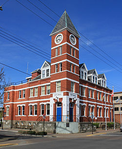
Duncan's farm was named Alderlea, and this was the first name of the adjacent settlement. In August 1886, the Esquimalt and Nanaimo Railway was opened. No stop had been scheduled at Alderlea for the inaugural train bearing Sir John A. Macdonald and Robert Dunsmuir. However, at Duncan's Crossing, the level crossing nearest Alderlea, a crowd of 2,000 had assembled around a decorated arch and the train came to an unplanned halt. [5] :69 According to this legend, a train station was established at the settlement and the city built around it. [6] Initially part of the District of North Cowichan, Duncan felt its needs as an urban settlement in the largely rural municipality were not being met, in particular the need to have proper roadways. [7] After a particularly wet winter in 1911–1912, a vote was held to make Duncan a distinct city, and it was incorporated on March 4, 1912. [8] With the enlargement of North Cowichan in the ensuing decades, there was an effort to re-unite the two municipalities, though a referndum on the matter in June 1978 was soundly defeated. [9]

In the early 1900s, Duncan's Chinatown was the social centre for the Cowichan Valley's Chinese population. Chinatown was concentrated in a single block in the southwestern corner of Duncan. At its largest point, Duncan's Chinatown included six Chinese families and 30 merchants who supplied goods and services to the loggers, millworkers, cannery and mine workers in the area. [10] The city tore the buildings down in 1969 to build a new law courts complex. Some materials from the original buildings were used at Whippletree Junction. [11]

In the 1980s, the city was noted in coverage related to the 1985 bombings at Narita Airport in Japan and aboard Air India Flight 182, Canada's largest murder case. Resident Inderjit Singh Reyat purchased bomb parts and a radio at Duncan stores, and used the radio to conceal the bomb. Less than two weeks prior to the bombings, Reyat and suspected Air India mastermind Talwinder Singh Parmar were observed testing explosives in the woods outside of Duncan by the Canadian Security Intelligence Service (CSIS). [12]

Demographics

In the 2021 Census of Population conducted by Statistics Canada, Duncan had a population of 5,047 living in 2,454 of its 2,620 total private dwellings, a change of

Ethnicity

Panethnic groups in the City of Duncan (1986−2021)
Panethnic
group
2021 [14] 2016 [15] 2011 [16] 2006 [17] 2001 [18] 1996 [19] 1991 [20] [21] 1986 [22] [23] [24] :97
Pop. %Pop.%Pop.%Pop.%Pop.%Pop.%Pop.%Pop.%
European [lower-alpha 1] 3,6253,6053,7404,1553,5303,8103,6203,380
Indigenous 760630485525735395200300
Southeast Asian [lower-alpha 2] 603510560003015
African 5560020201500
South Asian 406540355075160105
East Asian [lower-alpha 3] 30407080901154570
Latin American 20150100000
Middle Eastern [lower-alpha 4] 1000002005
Other/Multiracial [lower-alpha 5] 252500200
Total responses4,6454,4704,4604,8854,4404,4304,0553,875
Total population5,0474,9444,9324,9864,6994,5884,3014,039
Note: Totals greater than 100% due to multiple origin responses

Religion

According to the 2021 census, religious groups in Duncan included: [14]

Religious groups in Duncan (1991−2021)
Religious group 2021 [14] 2011 [16] 2001 [18] 1991 [20]
Pop. %Pop.%Pop.%Pop.%
Christian 1,5902,2002,5152,730
Indigenous spirituality 450N/AN/AN/AN/A
Sikh 302560130
Jewish 250100
Buddhist 2030500
Muslim 15000
Hindu 0000
Other religion14090400
Irreligious 2,7802,1001,7601,185
Total responses4,6454,4604,4404,055

Attractions

The City of Duncan was incorporated in 1912 and is known for one of the largest totem pole collections. The City was officially named "City of Totems" in 1985. The City had 44 totem poles in the collection, however one was destroyed in an auto accident, one was gifted to Kaikohe, New Zealand and one returned to earth. In 2007, the City of Duncan deemed copyright privileges of the totem poles. The use of the totems' images for commercial purposes requires the City of Duncan's approval. [25] The Cowichan Historical Society (Museum) provides free totem tours in the summer months.

Duncan has a large Indigenous community and is the traditional home of the Cowichan Tribes, who are the largest band among the Coast Salish people. The Coast Salish men and women of the Cowichan Tribes are makers of the world-famous Cowichan Sweaters.

Before the Canada–United States softwood lumber dispute, Duncan and the whole Cowichan Valley were a thriving lumber centre in British Columbia.

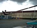
Cowichan Community Centre is located in the jurisdiction of the Municipality of North Cowichan, and serves purpose for all citizens in the Cowichan Valley Regional District (CVRD), including swimming and skating facilities. The centre has the world's largest hockey stick which was made specifically for Expo 86 in Vancouver, and purchased by CVRD at the end of the event.

Climate

According to the Köppen climate classification, Duncan has a warm-summer Mediterranean climate (Köppen Csb).

Climate data for Duncan Forestry; 6 m (20 ft) asl (1971–2000 normals)
MonthJanFebMarAprMayJunJulAugSepOctNovDecYear
Record high °C (°F)15.0
(59.0)
19.4
(66.9)
21.1
(70.0)
25.6
(78.1)
33.5
(92.3)
41.5
(106.7)
38.2
(100.8)
37.5
(99.5)
34.5
(94.1)
28.4
(83.1)
18.9
(66.0)
17.0
(62.6)
41.5
(106.7)
Mean daily maximum °C (°F)6.1
(43.0)
8.0
(46.4)
10.6
(51.1)
13.9
(57.0)
17.4
(63.3)
20.3
(68.5)
23.3
(73.9)
23.6
(74.5)
20.3
(68.5)
14.8
(58.6)
8.8
(47.8)
6.3
(43.3)
14.5
(58.1)
Daily mean °C (°F)2.6
(36.7)
4.1
(39.4)
5.9
(42.6)
8.5
(47.3)
11.9
(53.4)
14.7
(58.5)
17.0
(62.6)
17.1
(62.8)
13.8
(56.8)
9.3
(48.7)
5.0
(41.0)
2.9
(37.2)
9.4
(48.9)
Mean daily minimum °C (°F)−1.1
(30.0)
0.1
(32.2)
1.2
(34.2)
3.0
(37.4)
6.2
(43.2)
9.1
(48.4)
10.7
(51.3)
10.5
(50.9)
7.2
(45.0)
3.8
(38.8)
1.2
(34.2)
−0.5
(31.1)
4.3
(39.7)
Record low °C (°F)−21.1
(−6.0)
−15.5
(4.1)
−12.0
(10.4)
−3.9
(25.0)
−2.2
(28.0)
1.7
(35.1)
3.3
(37.9)
2.2
(36.0)
−3.0
(26.6)
−6.7
(19.9)
−17.0
(1.4)
−21.7
(−7.1)
−21.7
(−7.1)
Average precipitation mm (inches)145.3
(5.72)
130.1
(5.12)
101.7
(4.00)
54.0
(2.13)
44.4
(1.75)
37.3
(1.47)
20.3
(0.80)
25.3
(1.00)
46.7
(1.84)
80.0
(3.15)
168.8
(6.65)
185.5
(7.30)
1,039.2
(40.91)
Average rainfall mm (inches)129.5
(5.10)
122.2
(4.81)
99.7
(3.93)
53.9
(2.12)
44.4
(1.75)
37.3
(1.47)
20.3
(0.80)
25.3
(1.00)
46.7
(1.84)
79.5
(3.13)
163.3
(6.43)
171.1
(6.74)
993.1
(39.10)
Average snowfall cm (inches)15.8
(6.2)
7.9
(3.1)
2.0
(0.8)
0.2
(0.1)
0.0
(0.0)
0.0
(0.0)
0.0
(0.0)
0.0
(0.0)
0.0
(0.0)
0.4
(0.2)
5.4
(2.1)
14.4
(5.7)
46.1
(18.1)
Source: Environment Canada [26]
Climate data for Duncan Kelvin Creek; 103 m (338 ft) asl (1971–2000 normals)
MonthJanFebMarAprMayJunJulAugSepOctNovDecYear
Record high °C (°F)16.5
(61.7)
18.5
(65.3)
23.5
(74.3)
28.5
(83.3)
32.0
(89.6)
34.0
(93.2)
36.0
(96.8)
34.5
(94.1)
35.0
(95.0)
27.0
(80.6)
18.0
(64.4)
17.5
(63.5)
36.0
(96.8)
Mean daily maximum °C (°F)6.8
(44.2)
8.7
(47.7)
11.2
(52.2)
14.8
(58.6)
18.4
(65.1)
21.3
(70.3)
24.7
(76.5)
24.6
(76.3)
22.1
(71.8)
15.1
(59.2)
9.5
(49.1)
6.2
(43.2)
15.3
(59.5)
Daily mean °C (°F)3.6
(38.5)
4.4
(39.9)
6.3
(43.3)
9.1
(48.4)
12.4
(54.3)
15.3
(59.5)
17.9
(64.2)
17.8
(64.0)
15.2
(59.4)
10.1
(50.2)
5.8
(42.4)
3.3
(37.9)
10.1
(50.2)
Mean daily minimum °C (°F)0.3
(32.5)
0.0
(32.0)
1.4
(34.5)
3.4
(38.1)
6.3
(43.3)
9.1
(48.4)
11.1
(52.0)
11.0
(51.8)
8.1
(46.6)
5.1
(41.2)
2.1
(35.8)
−0.4
(31.3)
4.8
(40.6)
Record low °C (°F)−21.1
(−6.0)
−15.5
(4.1)
−12.0
(10.4)
−3.9
(25.0)
−2.2
(28.0)
1.7
(35.1)
3.3
(37.9)
2.2
(36.0)
−3.0
(26.6)
−6.7
(19.9)
−17.0
(1.4)
−21.7
(−7.1)
−21.7
(−7.1)
Average precipitation mm (inches)248.3
(9.78)
139.1
(5.48)
135.4
(5.33)
82.6
(3.25)
49.1
(1.93)
36.7
(1.44)
22.3
(0.88)
33.2
(1.31)
31.6
(1.24)
119.4
(4.70)
227.9
(8.97)
235.6
(9.28)
1,361.2
(53.59)
Average rainfall mm (inches)225.2
(8.87)
125.9
(4.96)
125.9
(4.96)
82.6
(3.25)
49.1
(1.93)
36.7
(1.44)
22.3
(0.88)
33.2
(1.31)
31.6
(1.24)
119.1
(4.69)
219.7
(8.65)
218.0
(8.58)
1,289.2
(50.76)
Average snowfall cm (inches)23.0
(9.1)
13.2
(5.2)
9.6
(3.8)
0.1
(0.0)
0.0
(0.0)
0.0
(0.0)
0.0
(0.0)
0.0
(0.0)
0.0
(0.0)
0.4
(0.2)
8.3
(3.3)
17.6
(6.9)
72.0
(28.3)
Source: Environment Canada [27]

Education

Duncan is part of British Columbia's School District 79 Cowichan Valley. It has one independent school. Queen Margaret's School, established in 1921, as a private secondary university preparatory school which includes a co-ed junior school.

Vancouver Island University (formerly Malaspina University-College) has a regional campus in the Municipality of North Cowichan, bordering Duncan, that offers a Bachelor of Education degree as well as programs and courses in university transfer, access, trades and applied technology, health and human services, and career and academic preparation. The campus also has a Continuing Education department that offers certificate programs, personal and professional development courses, and online courses. The current 55,000-square-foot (5,100 m2) campus opened for classes in June 2011.

Also bordering Duncan in the Municipality of North Cowichan, there are two public secondary schools, Cowichan Secondary School, and Quamichan Secondary School, as well as several elementary schools. The head offices of School District 79 Cowichan Valley are also located in North Cowichan. In the Cowichan region there are also has two denominational independent schools: Queen of Angels (Catholic school), serving preschool to Grade 9 students, and Duncan Christian School, whose campus is home to both an independent elementary and high school. Sunrise Waldorf School is a non-denominational K-8 independent school offering Waldorf education in the Cowichan Valley.

Sports

The Cowichan Community Sportsplex is located on the border of Duncan, but in the Municipality of North Cowichan and is the home of the British Columbia Hockey League's Cowichan Valley Capitals, who play in the Cowichan Community Sportsplex. It is home to a number of other sports and athletics organizations including the Cowichan Valley Athletic Club's (CVAC) Jaguars one of the many clubs and teams that practice & compete out of the extensive Cowichan Sportsplex.

Notable people

See also Category:People from Duncan, British Columbia

See also

Notes

  1. Statistic includes all persons that did not make up part of a visible minority or an indigenous identity.
  2. Statistic includes total responses of "Filipino" and "Southeast Asian" under visible minority section on census.
  3. Statistic includes total responses of "Chinese", "Korean", and "Japanese" under visible minority section on census.
  4. Statistic includes total responses of "West Asian" and "Arab" under visible minority section on census.
  5. Statistic includes total responses of "Visible minority, n.i.e." and "Multiple visible minorities" under visible minority section on census.

Related Research Articles

<span class="mw-page-title-main">Fernie, British Columbia</span> City in British Columbia, Canada

Fernie is a city in the Elk Valley area of the East Kootenay region of southeastern British Columbia, Canada, located on BC Highway 3 on the western approaches to the Crowsnest Pass through the Rocky Mountains. Founded in 1898 and incorporated as the City of Fernie in July 1904, the municipality has a population of over 5,000 with an additional 2,000 outside city limits in communities under the jurisdiction of the Regional District of East Kootenay. A substantial seasonal population swells the city during the winter months.

<span class="mw-page-title-main">Alberni-Clayoquot Regional District</span> Regional district in British Columbia, Canada

The Alberni–Clayoquot Regional District of British Columbia is located on west central Vancouver Island. Adjacent regional districts it shares borders with are the Strathcona and Comox Valley Regional Districts to the north, and the Nanaimo and Cowichan Valley Regional Districts to the east. The regional district offices are located in Port Alberni.

<span class="mw-page-title-main">Esquimalt</span> Township in British Columbia, Canada

The Township of Esquimalt is a municipality at the southern tip of Vancouver Island, in British Columbia, Canada. It is bordered to the east by the provincial capital, Victoria, to the south by the Strait of Juan de Fuca, to the west by Esquimalt Harbour and Royal Roads, to the northwest by the New Songhees 1A Indian reserve and the town of View Royal, and to the north by a narrow inlet of water called the Gorge, across which is the district municipality of Saanich. It is almost tangential to Esquimalt 1 Indian Reserve near Admirals Road. It is one of the 13 municipalities of Greater Victoria and part of the Capital Regional District.

<span class="mw-page-title-main">Parksville, British Columbia</span> City in British Columbia, Canada

Parksville is a city on Vancouver Island in British Columbia, Canada. As of the 2021 Census, Parksville's population was 13,642, representing a 9.5% increase over the 2016 Census.

<span class="mw-page-title-main">Ladysmith, British Columbia</span> Town in British Columbia, Canada

Ladysmith, originally Oyster Harbour, is a town located on the 49th parallel north on the east coast of Vancouver Island, British Columbia, Canada. The local economy is based on forestry, tourism, and agriculture. A hillside location adjacent to a sheltered harbour forms the natural geography of the community.

<span class="mw-page-title-main">Sparwood</span> District municipality in British Columbia, Canada

Sparwood is a district municipality in the Canadian province of British Columbia. It is the second-largest community on the Elk River.

<span class="mw-page-title-main">Golden, British Columbia</span> Town in British Columbia, Canada

Golden is a town in southeastern British Columbia, Canada, 262 kilometres (163 mi) west of Calgary, Alberta, and 713 kilometres (443 mi) east of Vancouver.

<span class="mw-page-title-main">Greater Vancouver</span> Metropolitan area in British Columbia, Canada

Greater Vancouver, also known as Metro Vancouver, is the metropolitan area with its major urban centre being the city of Vancouver, British Columbia, Canada. The term "Greater Vancouver" describes an area that is roughly coterminous with the region governed by the Metro Vancouver Regional District (MVRD), though it predates the 1966 creation of the regional district. It is often used to include areas beyond the boundaries of the regional district but does not generally include wilderness and agricultural areas that are included within the MVRD.

<span class="mw-page-title-main">North Cowichan</span> District municipality in British Columbia, Canada

North Cowichan is a district municipality established in 1873 on Vancouver Island, in British Columbia, Canada. The municipality is part of the Cowichan Valley Regional District. North Cowichan is noted for a landscape including forests, beaches, rivers, and lakes. The municipality encompasses the communities of Chemainus; Westholme; Crofton; Maple Bay; and "the South End". The latter is an informal name for a built-up area which is essentially a suburb of the City of Duncan, a separate municipality.

Lantzville is a coastal community on the east side of Vancouver Island, British Columbia, Canada, along the western shore of the Strait of Georgia and immediately north of Nanaimo.

<span class="mw-page-title-main">Regional District of Nanaimo</span> Regional district in British Columbia, Canada

The Regional District of Nanaimo is a regional district located on the eastern coast of Vancouver Island, British Columbia, Canada. It is bordered to the south by the Cowichan Valley Regional District, to the west by the Alberni-Clayoquot Regional District, and to the northwest by the Comox Valley Regional District. Its administration offices are located in Nanaimo. During the 2016 census, its population was established at 155,698.

<span class="mw-page-title-main">Cowichan Valley Regional District</span> Regional district in British Columbia, Canada

The Cowichan Valley Regional District is a regional district in the Canadian province of British Columbia is on the southern part of Vancouver Island, bordered by the Nanaimo and Alberni-Clayoquot Regional Districts to the north and northwest, and by the Capital Regional District to the south and east. As of the 2021 Census, the Regional District had a population of 89,013. The regional district offices are in Duncan.

<span class="mw-page-title-main">Enderby, British Columbia</span> City in British Columbia, Canada

The City of Enderby is in the North Okanagan region of the Canadian province of British Columbia, between Armstrong and Salmon Arm. It is approximately 80 km north of Kelowna and 130 km east of Kamloops. Highway 97A passes through Enderby and the Shuswap River marks the eastern and northeastern limits of the City. There are two major schools in Enderby: M.V. Beattie Elementary School and A.L. Fortune Secondary School. M.V. Beattie Elementary School was rebuilt in 2012.

<span class="mw-page-title-main">Port Hardy</span> District municipality in British Columbia, Canada

Port Hardy is a district municipality in British Columbia, Canada located on the north-east end of Vancouver Island. Port Hardy has a population of 3,902 as of the 2021 census.

The demographics of Metro Vancouver indicate a multicultural and multiracial region. Metro Vancouver is a metropolitan area, with its major urban centre being Vancouver, British Columbia, Canada. The Vancouver census metropolitan area, as defined by Statistics Canada, encompasses roughly the same territory as the Metro Vancouver Regional District, a regional district in British Columbia. The regional district includes 23 local authorities. Figures provided here are for the Vancouver census metropolitan area and not for the City of Vancouver.

Lake Cowichan is a town located on the east end of Cowichan Lake and, by highway, is 27 kilometres (17 mi) west of Duncan, British Columbia. The town of Lake Cowichan was incorporated in 1944. The Cowichan River flows through the middle of the town. Cowichan River is designated as a Heritage River.

<span class="mw-page-title-main">Comox Valley Regional District</span> Regional district in British Columbia, Canada

The Comox Valley Regional District is a regional district in British Columbia, Canada. It was created on February 15, 2008, encompassing the southeastern portions of the former Regional District of Comox-Strathcona, and centred about the Comox Valley. The partition left the new Comox Valley Regional District with only 8.4 percent of the former Comox-Strathcona's land area, but 57.9 percent of its population. The CVRD covers an area of 2,425 square kilometres, of which 1,725 square kilometres is land, and serves a population of 72,445 according to the 2023 Census. The district borders the Strathcona Regional District to the northwest, the Alberni-Clayoquot Regional District to the southwest, and the Regional District of Nanaimo to the southeast, as well as the qathet Regional District along the Strait of Georgia to the east.

<span class="mw-page-title-main">Cowichan—Malahat—Langford</span> Federal electoral district in British Columbia, Canada

Cowichan—Malahat—Langford is a federal electoral district in British Columbia, Canada. It is on south-central Vancouver Island. It encompasses a portion of British Columbia previously included in the electoral districts of Nanaimo—Cowichan and Esquimalt—Juan de Fuca.

<span class="mw-page-title-main">Nanaimo—Ladysmith</span> Federal electoral district in British Columbia, Canada

Nanaimo—Ladysmith is a federal electoral district in British Columbia, in southeastern Vancouver Island.

<span class="mw-page-title-main">South Asian Canadians in British Columbia</span>

The South Asian community in British Columbia was first established in 1897. The first immigrants originated from Punjab, British India, a northern region and state in modern-day India and Pakistan. Punjabis originally settled in rural British Columbia at the turn of the twentieth century, working in the forestry and agricultural industries.

References

  1. 1 2 "Duncan". The Canadian Encyclopedia. Retrieved 15 June 2014.
  2. "Reports & Statistics | Cowichan Valley Regional District". www.cvrd.bc.ca. Retrieved 2019-04-10.
  3. "Duncan". BC Geographical Names .
  4. Henry, Tom (1999). Small City in a Big Valley: The Story of Duncan. Madeira Park, British Columbia: Harbour Publisher. p. 8. ISBN   1-55017-212-3.
  5. 1 2 Akrigg, G.P.V.; Akrigg, Helen B. (1986), British Columbia Place Names (3rd, 1997 ed.), Vancouver: UBC Press, ISBN   0-7748-0636-2
  6. Henry. Small City in a Big Valley. p. 30.
  7. Henry. Small City in a Big Valley. pp. 65–67.
  8. Henry. Small City in a Big Valley. p. 69.
  9. Henry. Small City in a Big Valley. p. 164.
  10. Henry. Small City in a Big Valley. p. 109.
  11. Henry. Small City in a Big Valley. p. 162.
  12. Sikh probe took wrong turn after Duncan blast: former CSIS agent, CBC News, May 24, 2007
  13. "Population and dwelling counts: Canada, provinces and territories, and census subdivisions (municipalities), British Columbia". Statistics Canada. February 9, 2022. Retrieved February 20, 2022.
  14. 1 2 3 Government of Canada, Statistics Canada (2022-10-26). "Census Profile, 2021 Census of Population". www12.statcan.gc.ca. Retrieved 2022-11-11.
  15. Government of Canada, Statistics Canada (2021-10-27). "Census Profile, 2016 Census". www12.statcan.gc.ca. Retrieved 2023-03-16.
  16. 1 2 Government of Canada, Statistics Canada (2015-11-27). "NHS Profile". www12.statcan.gc.ca. Retrieved 2023-03-16.
  17. Government of Canada, Statistics Canada (2019-08-20). "2006 Community Profiles". www12.statcan.gc.ca. Retrieved 2023-03-16.
  18. 1 2 Government of Canada, Statistics Canada (2019-07-02). "2001 Community Profiles". www12.statcan.gc.ca. Retrieved 2023-03-16.
  19. Government of Canada, Statistics Canada (2019-06-04). "Electronic Area Profiles Profile of Census Divisions and Subdivisions, 1996 Census". www12.statcan.gc.ca. Retrieved 2023-03-16.
  20. 1 2 Government of Canada, Statistics Canada (2019-03-29). "1991 Census Area Profiles Profile of Census Divisions and Subdivisions - Part B". www12.statcan.gc.ca. Retrieved 2023-03-16.
  21. Government of Canada, Statistics Canada (2019-03-29). "Data tables, 1991 Census Population by Ethnic Origin (24), Showing Single and Multiple Origins (2) - Canada, provinces and territories, census divisions and census subdivisions". www12.statcan.gc.ca. Retrieved 2023-03-16.
  22. Government of Canada, Statistics Canada (2019-06-27). "Data tables, 1986 Census Census Profile for Canada, Provinces and Territories, Census Divisions and Census Subdivisions, 1986 Census - Part A". www12.statcan.gc.ca. Retrieved 2023-03-16.
  23. Government of Canada, Statistics Canada (2019-06-27). "Data tables, 1986 Census Census Profile for Canada, Provinces and Territories, Census Divisions and Census Subdivisions, 1986 Census - Part B". www12.statcan.gc.ca. Retrieved 2023-03-16.
  24. Government of Canada, Statistics Canada (2013-04-03). "Canada's aboriginal population by census subdivisions from the 1986 Census of Canada". www12.statcan.gc.ca. Retrieved 2023-03-16.
  25. "Duncan Council Policy Manual | Totem Image Use" . Retrieved 2022-02-10.
  26. Environment CanadaCanadian Climate Normals 1971–2000 Duncan Forestry, accessed 20 November 2018
  27. Environment CanadaCanadian Climate Normals 1981-2010 Station Data Duncan Kelvin Creek, accessed 26 April 2018

48°46′43.3″N123°42′28.3″W / 48.778694°N 123.707861°W / 48.778694; -123.707861