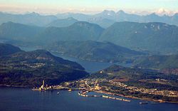
Powell River is a city on the northern Sunshine Coast of southwestern British Columbia, Canada.[5] Most of its population lives near the eastern shores of Malaspina Strait, which is part of the larger Georgia Strait between Vancouver Island and the Mainland. With two intervening long, steep-sided fjords inhibiting the construction of a contiguous road connection with Vancouver to the south, geographical surroundings explain Powell River's remoteness as a community, despite relative proximity to Vancouver and other populous areas of the BC Coast. The city is the location of the head office of the qathet Regional District.
The Powell River was named for Israel Wood Powell. Powell was B.C.'s first superintendent for Indian Affairs and a chief architect of colonial policies, including the establishment of residential schools in British Columbia and the banning of the Potlatch. He was traveling up the coast of BC in 1881 and the river and lake were named after him.[6][7]
Powell was a supporter of B.C. being part of the union with Canada and brought the first Canadian flag to BC on June 17, 1871.
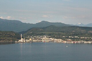
The pulp mill was started in 1908, with a corresponding townsite company town commenced in 1910: the first roll of paper was produced at Powell River Mill in 1912. Similarly, large logging companies had earlier moved in to take advantage of the huge timber. Brooks, Scanlon & Obrien; Bloedel, Stewart and Welch; and Theodosia Logging were but a few logging companies, with the Brooks brothers and M.J. Scanlon forming the Powell River Company, western Canada's first pulp and paper mill. The Historic Townsite was designated a National Historic Site of Canada in 1995, recognizing the exceptionally well preserved early 20th Century planned community, rooted firmly in the Garden City Design Movement and the Arts and Crafts philosophy.[8]
When the British Columbia Credit Unions Act was passed in 1939, a study club organized by local millworkers secured the first charter with a deposit of $48.30. The mill provided a small office space at very low rent in the early years. By 1955, when the Powell River Credit Union (now 'First Credit Union') moved into a permanent office, it had over 3,000 members and $1 million in assets.[9]
The mill in Powell River was at one time the largest pulp and paper mill in the world. In its prime, one in every 25 newspapers in the world was printed on paper from the Powell River mill. However, since then it has significantly cut back on production and now produces newsprint and specialty papers for Catalyst Paper. The mill is downsizing, and only three paper machines (#9, #10 and #11) remain in production, thus laying off hundreds of employees. The subsequent diversification of the local economy led to an increased focus on ecotourism and the arts, in addition to more traditional resources like mining, fishing, and general forestry. In recognition of its strong arts and cultural programs, Powell River was named a "Cultural Capital of Canada" in 2004.
The Powell River area is the current home to the Tla A'min Nation of the Mainland Comox branch of the Coast Salish peoples, who still reside there to this day. Their village is commonly referred to as Sliammon (the usual English adaptation of Tla'Amin).
Name change
In May 2021, Tla'amin Nation submitted a request to Powell River city council requesting a change in the name. The request comes because City namesake Israel Powell, B.C.’s superintendent of Indian affairs from 1872 to 1889, helped to ensure that the sale of Lot 450, land that included tiyskʷat village, went through, as well as overseeing the removal of children from their homes to be sent to residential schools, and the banning of potlatch, language and other Indigenous customs.[10]
Sports teams
Powell River is host to the Powell River Kings, a member team of the British Columbia Hockey League, and Powell River Villa, who play in the Vancouver Island Soccer League. Powell River also has many youth sports teams and associations. PRMHA is the minor hockey associations with house & rep teams. Powell River's gymnastics association has produced many reputable gymnasts.[citation needed]
Powell River's youth baseball league is called the P.R.M.B.A. It consists of six different age groups known as T-Ball, Tadpole, Mosquito, Pee Wee, Bantam, and Midget/Junior.[11]
Attractions
In 2020, Powell River received a $10,000 grant from the government of British Columbia to support tourism in the town.[12] Nearby Texada Island with quiet beaches and lakes provides tourism opportunities and is a common weekend destination for the cities' residents. Both Texada Island and Powell River are popular for fishing, hunting, sailing, power boating camping and remote hiking.
The Spanish renaissance-style Patricia Theatre is Canada's oldest continuously operating theatre, first built in 1913 and then rebuilt in 1928. The qathet Museum and Archives depicts the interactions between the pioneers and First Nations as well as showing the tools and items that would have been used by those groups. The Townsite Heritage Society was formed in 1992 to maintain and promote the historical character of the traditional neighbourhood and business section of the Powell River Townsite.[13]
Powell River hosts a number of festivals that highlight local interest and culture, including the Blackberry Festival, Pacific Region International Summer Music Academy (PRISMA) Festival, Townsite Jazz Festival, International Choral Kathaumixw, and the Sunshine Music Festival.
Powell River is home to the Sunshine Coast Trail,[14] Canada's longest hut-to-hut hiking trail.[15] The free-access 180 kilometre back-country trail meanders through a wide variety of landscapes, including coastal shorelines, old-growth forest, panoramic mountaintops, pristine creeks and lakes and salmon streams.[16]
Transportation
Ports at Powell River
While located on the mainland and not an island by definition, Powell River is a community isolated by ocean and mountains and is only accessible by water (BC Ferries) or by air (Powell River Airport). Powell River is located on Highway 101 but driving the length of the highway requires two ferries before arriving at Horseshoe Bay in West Vancouver. The alternative access to the town is a ferry crossing from Comox on Vancouver Island. Since the Sunshine Coast is similarly isolated from the rest of the BC mainland, vehicles from Vancouver must take two ferries to reach Powell River (across Howe Sound and the Jervis Inlet, if travelling via Sechelt; and across Georgia Strait twice if going via Nanaimo). The surrounding inlets (fjords) banked by mountainous terrain have made land based road connections to other areas of the BC mainland an expensive proposal. One land based route connecting Powell River to Highway 99 near Squamish has been studied, but would require two tunnels (4.5km and 8.0km long) and cost around 5 billion dollars.[17] All of the city's roads are two-lane residential roads, and Highway 101 merges with Marine Avenue to form the city's main street.
Powell River has a small airport with a single 1,200 meter long runway and indoor waiting terminal. It is serviced by Pacific Coastal Airlines, which offers 20- to 25-minute flights between Powell River Airport and the South Terminal of Vancouver's International Airport. Charter flights and private aircraft also make use the runway on a regular basis.
The City of Powell River also has a small network of public transportation bus routes, run by BC Transit with 6 routes.[18]
City of Powell River
The City of Powell River includes the original Townsite, which became designated a National Historic District in 1995, one of only seven in Canada. There is also the more populous Westview, and the Cranberry and Wildwood areas. On October 15, 2005, coinciding with its 50th anniversary of incorporation, Powell River was officially designated a city.
Townsite and Cranberry are connected by three roads by the names of Lombardy Ave,[19] Timberlane Ave,[20] and Hemlock Street.[21]
Demographics
In the 2021 Census of Population conducted by Statistics Canada, Powell River had a population of 13,943 living in 6,402 of its 6,718 total private dwellings, a change of 6% from its 2016 population of 13,157. With a land area of 28.91km2 (11.16sqmi), it had a population density of 482.3/km2 (1,249.1/sqmi) in 2021.[22]
The median household income in 2005 for Powell River was $46,777, which is below the British Columbia provincial average of $52,709.[23]
Ethnicity
Panethnic groups in the City of Powell River (2001−2021)
The city has an exceptional Mediterranean climate of the warm-summer type (Köppen: Csb), resulting in the most northerly location in the northern hemisphere, being that in Europe it is 5° further south.[29] Although the hot season is dry, the vegetation reflects its location west of the mid-latitudes and who can describe the climate differently being situated within a temperate rainforest,[29] Coastal Western Hemlock biogeoclimatic zone the mild winters and high humidity (although it has a defined dry season) it owns a wide zone of growth with firs, cedars and conifers.[30] On average, the CWH is the rainiest biogeoclimatic zone in British Columbia. The zone typically has a cool mesothermal climate: cool summers (although hot dry spells can be frequent) and mild winters.
Mean annual temperature is about 8°C (46.4°F) and ranges from 5.2 to 10.5°C (41.4 to 50.9°F) among the CWH subzones. The mean monthly temperature is above 10°C (50°F) for 4–6 months of the year. The mean temperature of the coldest month is 0.2°C (32.4°F) and ranges from −6.6 to 4.7°C (20.1 to 40.5°F) among the subzones. Mean annual precipitation for the zone as a whole is 2,228mm (87.7in), and ranges from 1,000 to 4,400mm (39.4 to 173.2in) (and probably more in some areas). Less than 15% of total precipitation occurs as snowfall in the south, but as much as 40-50% in the northern parts of the zone.[31]
A regional campus of Vancouver Island University is located in Powell River. This campus is called tiwšɛmawtxw (tyew-shem-out), which means house of learning.[33] The name was a gift to the institution from the Tla’amin Nation Executive Council to acknowledge VIU's "readiness and willingness to participate and engage in meaningful reconciliation."[33]
The Powell River School Board (School District 47 Powell River) operates eight schools which includes Brooks Secondary School (high school), James Thomson, Henderson, Edgehill, Grief Point (now the location of Powell River Christian School), Kelly Creek, and Texada (elementaries) as well as Westview Learning Centre. In 2013, A brand new $15.6 million Elementary school named Westview Elementary was opened. It is the replacement of the old Grief Point School.
Private Other elementary schools in the region include Assumption Catholic School (Pre-School, K-9) and Powell River Christian School (Pre-School, K-9).
Power supply
East of Saltery Bay, a powerline crosses Jervis Inlet on a span of 3.1 kilometres (1.9mi).
↑ Statistic includes all persons that did not make up part of a visible minority or an indigenous identity.
↑ Statistic includes total responses of "Chinese", "Korean", and "Japanese" under visible minority section on census.
↑ Statistic includes total responses of "Filipino" and "Southeast Asian" under visible minority section on census.
↑ Statistic includes total responses of "West Asian" and "Arab" under visible minority section on census.
↑ Statistic includes total responses of "Visible minority, n.i.e." and "Multiple visible minorities" under visible minority section on census.
Related Research Articles
The Lower Mainland is a geographic and cultural region of the mainland coast of British Columbia that generally comprises the regional districts of Metro Vancouver and the Fraser Valley. Home to approximately 3.05million people as of the 2021 Canadian census, the Lower Mainland contains sixteen of the province's 30 most populous municipalities and approximately 60% of the province's total population.
Bowen Island, British Columbia, is an island municipality that is part of Metro Vancouver, and within the jurisdiction of the Islands Trust. Located in Howe Sound, it is approximately 6 kilometres (3.7 mi) wide by 12 kilometres (7.5 mi) long, and at its closest point is about 3 kilometres (1.9 mi) west of the mainland. There is regular ferry service from Horseshoe Bay provided by BC Ferries, and semi-regular water taxi services. The population of 4,256 is supplemented in the summer by about 1,500 visitors. It has a land area of 50.12 km2 (19.35 sq mi).
Port Alberni is a city located on Vancouver Island in the province of British Columbia, Canada. The city lies within the Alberni Valley at the head of the Alberni Inlet, Vancouver Island's longest inlet. It is the location of the head offices of the Alberni-Clayoquot Regional District. Port Alberni currently has a total population of 18,259.
West Vancouver is a district municipality in the province of British Columbia, Canada. A member municipality of the Metro Vancouver Regional District, West Vancouver is to the northwest of the city of Vancouver on the northern side of English Bay and the southeast shore of Howe Sound, and is adjoined by the District of North Vancouver to its east. Together with the District of North Vancouver and the City of North Vancouver, it is part of a local regional grouping referred to as the North Shore municipalities, or simply "the North Shore".
Campbell River is a city in British Columbia, Canada, on the east coast of Vancouver Island at the south end of Discovery Passage, which lies along the 50th parallel north along the important Inside Passage shipping route. Campbell River has a population of 32,588 and has long been touted as the "salmon capital of the world." Campbell River and Region are near the communities of Quadra and the Discovery Islands, Sayward, Oyster River, Gold River, Tahsis and Zeballos.
Prince Rupert is a port city in the province of British Columbia, Canada. Its location is on Kaien Island near the Alaskan panhandle. It is the land, air, and water transportation hub of British Columbia's North Coast, and has a population of 12,220 people as of 2016.
West Vancouver—Sunshine Coast—Sea to Sky Country is a federal electoral district in British Columbia, Canada, that has been represented in the House of Commons of Canada since 1997.
Sooke is a district municipality on the southern tip of Vancouver Island, Canada, 38 kilometres (24 mi) by road from Victoria, the capital of British Columbia. Sooke, the westernmost of Greater Victoria's Western Communities, is to the north and west of the Sooke Basin. It is a regional centre for residents in neighbouring communities, including Otter Point, Shirley and Jordan River.
The District of North Vancouver is a district municipality in British Columbia, Canada, and is part of Metro Vancouver. It surrounds the City of North Vancouver on three sides. It is largely characterized as a relatively quiet, affluent suburban hub home to many middle and upper-middle-class families. Homes in the District of North Vancouver generally range from mid-sized family bungalows to very large luxury houses. A number of dense multi-family and mixed-use developments have popped up across the district in recent years; however, the district remains a primarily suburban municipality. It is served by the Royal Canadian Mounted Police, British Columbia Ambulance Service, and the District of North Vancouver Fire Department.
The qathet Regional District is a regional district in the Canadian province of British Columbia. Its only incorporated municipality is the City of Powell River, although it includes a number of unincorporated areas. The district encompasses a land area of 5,075.33 square kilometres (1,959.60 sq mi). The district was formerly known as the Powell River Regional District. Because of frequent confusion between the identical names of Powell River district and city, the district's name was changed in 2018 to qathet, from q̓at̓ᶿət, meaning "working together, bringing together" in the Comox language of the Tla'amin Nation.
Castlegar is a community in the West Kootenay region of British Columbia, Canada. In the Selkirk Mountains, at the confluence of the Kootenay and Columbia Rivers, it is a regional trade and transportation centre, with a local economy based on forestry, mining and tourism.
The Sunshine Coast Regional District is a regional district in British Columbia, Canada. It is located on the southern mainland coast, across Georgia Strait from Vancouver Island. It borders on the qathet Regional District to the north, the Squamish-Lillooet Regional District to the east, and, across Howe Sound, the Metro Vancouver District to the south. The regional district offices are located in the District Municipality of Sechelt.
The Fraser Valley Regional District (FVRD) is a regional district in British Columbia, Canada. Its headquarters are in the city of Chilliwack. The FVRD covers an area of 13,361.74 km2 (5,159 sq mi). It was created in 1995 by an amalgamation of the Fraser-Cheam Regional District and Central Fraser Valley Regional District and the portion of the Dewdney-Alouette Regional District from and including the District of Mission eastwards.
Princeton is a town municipality in the Similkameen area of southern British Columbia, Canada. The former mining and railway hub lies at the confluence of the Tulameen into the Similkameen River, just east of the Cascade Mountains. It is at the junction of BC Highway 3 and 5A.
North Island—Powell River is a federal electoral district in British Columbia, Canada, that was represented in the House of Commons of Canada from 1988 to 1997, and again since 2015. This riding was created in 1987 from parts of Comox—Powell River riding and contested for the first time at the 34th federal election on 21 November 1988. It was abolished in 1996 when it was merged into Vancouver Island North riding, and it ceased to be represented in the House of Commons effective at the call of the 36th federal election on 2 June 1997.
The City of Enderby is in the North Okanagan region of the Canadian province of British Columbia, between Armstrong and Salmon Arm. It is approximately 80 km north of Kelowna and 130 km east of Kamloops. Highway 97A passes through Enderby and the Shuswap River marks the eastern and northeastern limits of the City. There are two major schools in Enderby: M.V. Beattie Elementary School and A.L. Fortune Secondary School. M.V. Beattie Elementary School was rebuilt in 2012.
Sechelt is a district municipality located on the lower Sunshine Coast of British Columbia. Approximately 50 km northwest of Vancouver, it is accessible from mainland British Columbia by a 40-minute ferry trip between Horseshoe Bay and Langdale, and a 25-minute drive from Langdale along Highway 101, also known as the Sunshine Coast Highway. The name Sechelt is derived from the she shashishalhem word shíshálh, the name of the First Nations people who first settled the area thousands of years ago.
Port Hardy is a district municipality in British Columbia, Canada located on the north-east tip of Vancouver Island. Port Hardy has a population of 3,902 as of the 2021 census.
The District of North Saanich is located on the Saanich Peninsula of British Columbia, approximately 25 km (16 mi) north of Victoria on southern Vancouver Island. It is one of the 13 Greater Victoria municipalities. The district is surrounded on three sides by 20 km (12 mi) of ocean shoreline, and consists of rural/residential areas and a large agricultural base. It is home to the Victoria International Airport and the Swartz Bay Ferry Terminal.
Queensborough is a neighbourhood in the city of New Westminster, British Columbia, Canada. It is on the eastern tip of Lulu Island on the Fraser River.
This page is based on this Wikipedia article Text is available under the CC BY-SA 4.0 license; additional terms may apply. Images, videos and audio are available under their respective licenses.