White Rock is named for a large white boulder on its beach near the promenade, a glacial erratic that migrated south during the last glaciation. The 486-ton granite boulder was kept white by shellfish-eating seabirds whose guano covered the rock so much that 19th-century sailors used it as a beacon. It is now kept white through monthly applications of white paint by the city parks department and has been a graffiti target.[citation needed] The White Rock Pier is located nearby.
The Straits Salish people dominated the region from Boundary Bay in the north to Birch Bay in the south (in the U.S.). Semiahmoo First Nation permanent encampments were known to exist between 1791, the first European contact, and the 1850s, the beginnings of European settlement. These were located along the waterfront at the eastern and western limits of the present City of White Rock. The Semiahmoo people also constructed forts as lookouts for raiders from the northern first nations; one is located in the Ocean Park area.
The Oregon boundary dispute culminated in the Oregon Treaty of 1846, which settled the outstanding border issues between Great Britain and the United States. Previously, these issues had been put on hold through a shared occupancy agreement of the Oregon territory by the two nations in the Treaty of 1818. In turn, the International Boundary Survey Commission began in 1857 to set the boundary between the United States and British North America, roughly along the 49th parallel, which runs through Semiahmoo Bay and Boundary Bay to Point Roberts, Washington.
The Semiahmoo Trail still exists in White Rock and South Surrey, running from the site of the Boundary Commission Camp at the estuary of the Campbell River, overland to Mud Bay north of Crescent Beach. An 1865 survey map calls this route the 'Telegraph Trail'. During the real-estate boom of the 1980s and 90s, the City of Surrey preserved much of the trail, extending it from 20 Avenue to the Nicomekl River. On 148 Street, a specially constructed "Semiahmoo Trail" pedestrian overpass keeps the trail intact.
Modern history
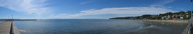
The city from White Rock Pier
The modern history of White Rock is directly tied to the railway linking British Columbia to Washington state, which runs along the shore of Semiahmoo Bay to the border. The rail is currently owned by BNSF Railway and runs alongside the promenade at the beach. This was originally the Great Northern line, and it opened up White Rock and Crescent Beach to tourists from Vancouver and New Westminster in the early 1900s.[5] The border crossing closest to White Rock (at Douglas, British Columbia, and Blaine, Washington) was officially opened in 1908, and the Peace Arch at the border crossing was constructed in the 1920s.
In 1913, the present railway station was opened, and the Fox and Hunter Shingle mill began operation. The Campbell River Mill also opened to the east, bringing a minor boom in the local economy. The now-famous pier was opened in 1914 to provide a deep-water mooring facility.
In the 1950s, White Rock residents began to feel isolated from the then–District of Surrey, where development was being concentrated elsewhere, particularly in North Surrey and Cloverdale. On April 15, 1957, a special warrant from the Government of British Columbia created the City of White Rock within its present boundary.
In the 1950s, Peace Arch Hospital opened and continues as a major employer in the city and health facility for the region.
Development was concentrated near the waterfront until the 1960s and 1970s. Many small cliffside dwellings were affordable to those unable to pay the cost of living closer to Vancouver. White Rock gained a reputation for being a retirement centre, as it features the lowest rainfall in the Metro Vancouver region, while benefitting from the influence of the ocean, keeping both summers highs and winter lows bearable.[6]
The development of Highway 99 and the opening of the Deas Island Tunnel (now the George Massey Tunnel) created a second boom for the White Rock area, providing a more convenient commuter route to Vancouver. No longer dependent upon the railway, development crept up the hillside. In the 1980s, the City of Surrey designated South Surrey as a town centre comparable to Guildford, Cloverdale, and Newton. The Semiahmoo Mall opened in Surrey on the north side of 16 Avenue (the south side of which is North Bluff Road within White Rock).
In 1979, chartered accountant Tom Kirstein and architect Chip Barrett organized an annual sandcastle competition,[7] which became internationally famous. The event took advantage of the long, sandy beach exposed at low tide, giving enough time for entrants to construct elaborate displays. Prizes of up to $10,000 were awarded, and crowds of 150,000 were estimated at the competition's height. In 1987, the contest was ended because of security costs and concerns. In 2008, a group of local high school students (Sara Woodward, Jorden Abernethy, Daniel Fowler, Michael Vanderpolder, and Tasha Svenson) and members of the community (Spenser Bolen, Michael Nolan, Trixie Nolan, and Lisa Nolan) launched a Sandcastle Competition revival. This competition drew 40,000 guests and over 70 teams.
The 1970s saw the White Rock/South Surrey area develop into a suburban bedroom community of the Lower Mainland. A real-estate boom in the area drew many young families to homes marketed to young professionals, a process that intensified in the mid-1990s. Today, many parts of the community resemble the type of suburban development seen across North America. Some cliffside cottages have given way to large homes, and multimillion-dollar properties have appeared in the area.
Uptown White Rock has been the site of significant new developments in recent years, with medium-rise condos becoming more prominent. The City of White Rock's fire department was located half a block north of its city limits until the early 1990s, when a new firehall was built across from City Hall. In 2007, the White Rock Little League team made it to the Little League World Series.
On December 20, 2018, during a severe windstorm, the White Rock Pier was severed when sailboats broke free from the attached marina and crashed into the pier destroying a 30-metre section.[8] At least 15 boats sank and several were wedged underneath the pier's pilings. Replacement plans call for a new pier that could be built by the end of August 2019, with an early cost estimate that is projected to be over $5 million.[9] As of May 2, 2019, the cost estimate for a rebuild to modern seismic standards is $16.2 million.[10] On August 28, 2019, the pier re-opened to the public although certain elements such as lighting have yet to be completed.[11] Darryl Walker has been mayor since 2018.[12]
Promenade and Semiahmoo Bay, from the pier
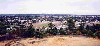
Geography
The boundaries between White Rock and Surrey are Bergstrom Road (136 Street) to the west, North Bluff Road (16th Avenue) to the north, Stayte Road (160 Street) to the east, and 8th Avenue to the south. The area south of 8 Avenue from Stayte Road westward to where 8 Avenue meets the water is the Semiahmoo Indian Reserve and lies within the bounds of the City of Surrey (though it is governed separately). The Surrey neighbourhoods of Ocean Park and Crescent Beach lie immediately to the northwest.
Climate
White Rock has a moderate climate, with average daily high temperatures of 23 degrees Celsius in summer and 6 degrees Celsius in winter.[13]
White Rock's climate is moderate year-round. Because the city is set away from the Coast Mountains, it sees less fog, fewer rainy days and shorter snowfalls. Meteorological statistics show that White Rock does, in fact, receive 20 percent more sunshine than does Vancouver. Temperatures average 21°C (70°F) in summer and 6°C (43°F) in winter. Annual rainfall averages 1,105mm (43.5in).[14]
In the 2021 Canadian census conducted by Statistics Canada, White Rock had a population of 21,939 living in 10,735 of its 11,541 total private dwellings, a change of 10% from its 2016 population of 19,952. With a land area of 5.17km2 (2.00sqmi), it had a population density of 4,243.5/km2 (10,990.7/sqmi) in 2021.[3]
Every year in July, the city hosts the Tour de White Rock, a bicycle road race that attracts over 150 local and international riders. In 2005, the event was part of the Canadian Cycling Association's national Road Race Series.
Every year during the first weekend of August, the Spirit of the Sea Festival is held on White Rock beach. It usually includes a parade, fireworks, music stages, a sandcastle competition, and various other beach-related activities. The festival began in 1949.
Infrastructure
Transportation
A freight train runs along the beach as the sun sets in 2009
Transportation in White Rock largely revolves around the automobile. Highway 99 is a freeway that links the White Rock area with Vancouver to the north and U.S. Interstate 5, via the Peace Arch border crossing, to the south. King George Highway (Highway 99A) links the Peace Arch border with Surrey Central station and New Westminster via the soon-to-be-replaced Pattullo Bridge. Johnston Road (152 Street) links White Rock to Guildford and the Trans-Canada Highway (Highway 1).
Most of White Rock's bus routes run through the White Rock Centre transit exchange. From there, the 351 and 354 buses, which previously ran to downtown Vancouver, now terminate at Bridgeport station in Richmond; Vancouver-bound passengers have to transfer onto the Canada Line rapid transit line. Only one route serving the area, the 352 Ocean Park/Bridgeport Station express bus, does not run through White Rock Centre, instead terminating near the South Surrey Athletic Park. The 321, 345, and 394 buses provide service to North Surrey, notably to Surrey Central and King GeorgeSkytrain stations, and the 375 service runs through White Rock Centre from just north of the Peace Arch border crossing to Guildford Town Centre. The 531 bus runs from White Rock Centre to Willowbrook Mall in Langley. Community Shuttle routes, the 360, 361, 362, and 363, service local communities within White Rock and South Surrey.
BNSF Railway has a single-track main line through White Rock that runs the length of the White Rock beach promenade. The city itself has no train service; however, this rail line is a major corridor for goods transported between the ports of Vancouver and the continental U.S., as well as for the Amtrak Cascades passenger service between Seattle and Vancouver via Bellingham, Washington. The Canadian National Railway and the Canadian Pacific Railway (CPR) also have trackage rights along the line. Goods transported on the corridor include Canadian softwood lumber, coal, paper products, and general merchandise. The CPR runs regular potash trains along the line to the Canpotex export terminal in Oregon.[22]
Scenes from the boxing film Knockout were filmed in White Rock. Portions of the 1965 film The Railrodder starring Buster Keaton were filmed in White Rock. Much of the 1982 movie Big Meat Eater was filmed near and around the White Rock waterfront. The USA Network's detective comedy Psych was also filmed in White Rock, though the series is set in Santa Barbara, California. There is also a brief scene in Leaving Normal filmed at the White Rock waterfront. Scenes from The X-Files were also filmed here, as were scenes from the Steven Seagal movie Driven to Kill. An episode of the FXdramedy series Better Things from its second season titled "White Rock", that originally aired on November 9, 2017, had scenes that were filmed in White Rock. The Hallmark movie Like Cats & Dogs had many city scenes filmed here, as well as scenes on the public pier. K-pop girl group Twice features local White Rock gelato shop Ocean Rock Cafe on Marine Drive as well as the historic pier and railway in their 2018 music video Likey.
Notes
↑ Statistic includes all persons that did not make up part of a visible minority or an indigenous identity.
↑ Statistic includes total responses of "Chinese", "Korean", and "Japanese" under visible minority section on census.
↑ Statistic includes total responses of "Filipino" and "Southeast Asian" under visible minority section on census.
↑ Statistic includes total responses of "West Asian" and "Arab" under visible minority section on census.
↑ Statistic includes total responses of "Visible minority, n.i.e." and "Multiple visible minorities" under visible minority section on census.
Related Research Articles
The Lower Mainland is a geographic and cultural region of the mainland coast of British Columbia that generally comprises the regional districts of Metro Vancouver and the Fraser Valley. Home to approximately 3.05million people as of the 2021 Canadian census, the Lower Mainland contains sixteen of the province's 30 most populous municipalities and approximately 60% of the province's total population.
Campbell River is a city in British Columbia, Canada, on the east coast of Vancouver Island at the south end of Discovery Passage, which lies along the 50th parallel north along the important Inside Passage shipping route. Campbell River has a population of 32,588 and has long been touted as the "salmon capital of the world." Campbell River and Region are near the communities of Quadra and the Discovery Islands, Sayward, Oyster River, Gold River, Tahsis and Zeballos.
The Township of Esquimalt is a municipality at the southern tip of Vancouver Island, in British Columbia, Canada. It is bordered to the east by the provincial capital, Victoria, to the south by the Strait of Juan de Fuca, to the west by Esquimalt Harbour and Royal Roads, to the northwest by the New Songhees 1A Indian reserve and the town of View Royal, and to the north by a narrow inlet of water called the Gorge, across which is the district municipality of Saanich. It is almost tangential to Esquimalt 1 Indian Reserve near Admirals Road. It is one of the 13 municipalities of Greater Victoria and part of the Capital Regional District.
The Regional District of Kootenay Boundary (RDKB) is one of 28 regional districts in the province of British Columbia, Canada. As of the 2016 Canadian census, the population was 31,447. The area is 8,095.62 km2. The RDKB was incorporated in 1966 and consists of eight incorporated municipalities and five unincorporated electoral areas. The regional district's offices are in the City of Trail, with secondary offices in the City of Grand Forks. Other major population centres include the cities of Rossland and Greenwood, and the villages of Fruitvale, Warfield, and Montrose. The region also encompasses electoral areas A, B/Lower Columbia-Old Glory, C/Christina Lake, D/Rural Grand Forks and E/West Boundary including Rock Creek, Bridesville, Beaverdell and Big White Ski Resort.
The City of North Vancouver is a city on the north shore of Burrard Inlet, British Columbia, Canada. It is a suburb of Vancouver. It is the smallest in area and the most urbanized of the North Shore municipalities, although it has significant industry of its own – including shipping, chemical production, and film production. The city is served by the Royal Canadian Mounted Police, British Columbia Ambulance Service, and the North Vancouver City Fire Department.
Vancouver South is a federal electoral district in British Columbia, Canada, that has been represented in the House of Commons of Canada from 1917 to 1997, and since 2004. It covers the southern portion of the city of Vancouver, British Columbia.
Duncan is a city on southern Vancouver Island in British Columbia, Canada. It is the smallest city by area in Canada. It was incorporated in 1912.
Greater Vancouver, also known as Metro Vancouver, is the metropolitan area with its major urban centre being the city of Vancouver, British Columbia, Canada. The term "Greater Vancouver" describes an area that is roughly coterminous with the region governed by the Metro Vancouver Regional District (MVRD), though it predates the 1966 creation of the regional district. It is often used to include areas beyond the boundaries of the regional district but does not generally include wilderness and agricultural areas that are included within the MVRD.
North Cowichan is a district municipality established in 1873 on Vancouver Island, in British Columbia, Canada. The municipality is part of the Cowichan Valley Regional District. North Cowichan is noted for a landscape including forests, beaches, rivers, and lakes. The municipality encompasses the communities of Chemainus; Westholme; Crofton; Maple Bay; and "the South End". The latter is an informal name for a built-up area which is essentially a suburb of the City of Duncan, a separate municipality.
A visible minority is defined by the Government of Canada as "persons, other than aboriginal peoples, who are non-Caucasian in race or non-white in colour". The term is used primarily as a demographic category by Statistics Canada, in connection with that country's Employment Equity policies. The qualifier "visible" was chosen by the Canadian authorities as a way to single out newer immigrant minorities from both Aboriginal Canadians and other "older" minorities distinguishable by language and religion, which are "invisible" traits.
The Cowichan Valley Regional District is a regional district in the Canadian province of British Columbia that is on the southern part of Vancouver Island, bordered by the Nanaimo and Alberni-Clayoquot Regional Districts to the north and northwest, and by the Capital Regional District to the south and east. As of the 2021 Census, the Regional District had a population of 89,013. The regional district offices are in Duncan.
Fleetwood—Port Kells is a federal electoral district in the province of British Columbia, Canada, that has been represented in the House of Commons of Canada since 2004.
Delta is a federal electoral district in British Columbia, Canada, that was represented in the House of Commons of Canada from 1988 to 1997 and since 2015.
Port Hardy is a district municipality in British Columbia, Canada located on the north-east tip of Vancouver Island. Port Hardy has a population of 3,902 as of the 2021 census.
Grand Forks is a city in the Boundary Country of the West Kootenay region of British Columbia, Canada. It is located at the confluence of the Granby and Kettle Rivers, a tributary of the Columbia River. The city is just north of the Canada–United States border, approximately 500 km (310 mi) from Vancouver and 200 km (120 mi) from Kelowna and 23 km (14 mi) west of the resort area of Christina Lake by road.
The Regional District of Mount Waddington (RDMW) is a regional district in British Columbia. It takes in the lower Central Coast region centred on the Queen Charlotte Strait coast of northern Vancouver Island and the adjoining parts of mainland British Columbia. It has a total land area of 20,288.4 km2 and a 2016 census population of 11,035 persons, most of which is in towns on Vancouver Island and adjoining islands. The administrative centre is in the town of Port McNeill. Other municipalities include the district municipality of Port Hardy, the village of Port Alice, and the village of Alert Bay.
The demographics of Metro Vancouver indicate a multicultural and multiracial region. Metro Vancouver is a metropolitan area, with its major urban centre being Vancouver, British Columbia, Canada. The Vancouver census metropolitan area, as defined by Statistics Canada, encompasses roughly the same territory as the Metro Vancouver Regional District, a regional district in British Columbia. The regional district includes 23 local authorities. Figures provided here are for the Vancouver census metropolitan area and not for the City of Vancouver.
South Surrey—White Rock is a federal electoral district in British Columbia, Canada, that has been represented in the House of Commons of Canada since 2015. It encompass a portion of British Columbia previously included in the electoral districts of Fleetwood—Port Kells, Newton—North Delta, and South Surrey—White Rock—Cloverdale.
Surrey Centre is a federal electoral district in British Columbia. It encompasses a portion of British Columbia previously included in the electoral district of Surrey North.
Surrey—Newton is a federal electoral district in British Columbia. It encompasses a portion of British Columbia previously included in the electoral districts of Fleetwood—Port Kells, Newton—North Delta and Surrey North.
This page is based on this Wikipedia article Text is available under the CC BY-SA 4.0 license; additional terms may apply. Images, videos and audio are available under their respective licenses.