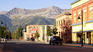
Rossland is in the West Kootenay region of south central British Columbia. High in the Monashee Mountains, the city lies immediately east of the intersections of BC highways 3B and 22.[3] The facilities provide a winter base for the nearby multi-peak ski hills of the Red Mountain Resort. In the non-winter months Rossland is frequented by mountain bikers, with golf and fishing options nearby as well.[4][5]
The Sinixt First Nation called the Rossland area kEluwi'sst or kmarkn. As to the word meanings, suggestions have included an "important temporary camp" or "up in the hills" for the former, and "smooth top" for the latter, referring to Red Mountain. Once mining claims were staked, the area became known as Trail Creek camp, the creek name derived from the Dewdney Trail.
The final naming acknowledged Ross Thompson, who preempted 160 acres in 1892. He subdivided the land into lots in 1894 to become the townsite of Thompson. A few months later, the name changed to Rossland.[6] The postal authorities may have requested the amendment to avoid confusion with similarly named places.[7]
First claims
In July 1890, partners Joe Bourjouis and Joe Morris staked claims on Red Mountain, but the assays were disappointing. Since an individual could register only two claims, the pair paid the $2.50 per claim to register the Center Star, War Eagle, Idaho and Virginia. For $10, they gave their Le Wise claim to the Deputy Recorder of Mines, "Colonel" Eugene Sayre Topping, to register for himself as Le Roi. Leaving government service, Topping joined a Spokane syndicate that purchased 53 per cent of the property from him for $16,000 that November. The following spring, several tons of ore went by mule down the mountain and along the Dewdney Trail to Trail Creek Landing at the creek mouth. Following boat transport to Little Dalles, Washington, the Spokane Falls and Northern Railway (SF&N), and connecting lines, railed the product to the Colorado Smelting and Mining Company Works at Butte, Montana.[8]
Wagon roads & deals
During 1891, a patchwork of mines operated on the mountain, Le Roi Mining and Smelting Company was incorporated, and Topping sold his remaining interest for $30,000. Late the next year, a ferry across the river from the SF&N station at Northport, Washington connected with Oliver Durant's new wagon road from Red Mountain. A fleet of 40 wagons to Northport largely replaced the mule trains to Trail. That year, Bourjouis and Morris sold their Center Star and War Eagle mines, which with the Le Roi, produced 96 per cent of the mountain's 1,500,000 tons of ore to 1903. In 1893, an 3-metre (11ft) wide wagon road was graded along Trail Creek, to win back traffic for Trail. The mountain output of 18,500 tons in 1894 increased ten-fold the next year.[8]
Early railways & consolidation
In June 1896, the first loaded ore train ran along the initial section of Heinze's Columbia and Western Railway (C&W) from Red Mountain to the Trail smelter arbitration (1938–1942). After a delay over a US right-of-way, Corbin's Red Mountain–Northport railway, comprising the Red Mountain Railway (RMR) (BC section) and Columbia & Red Mountain Railway (C&RM) (WA section), opened in December 1896.[9] The next year, Le Roi's contract to exclusively supply the Trail smelter expired.[10] When Le Roi owners opened the Northport smelter in January 1898, competition further intensified. That March, Canadian Pacific Railway (CP) purchased the C&W and Trail smelter. That July, the Northern Pacific Railway (NP) acquired the RMR, C&RM, and Northport smelter.[9] That August, British America Corporation completed its purchase of Le Roi holdings.[11]
Early community
Fire Hall, Rossland, 1909
Since miners did not own the land upon which their tents or shacks stood, many acquired freehold lots in town for permanent residences. In February 1895, the first edition of the Rossland Record listed a blacksmith, a tinsmith, a cobbler, a customs agent, a baker, a land surveyor, a lawyer, two sawyers, two barbers, three doctors, four bartenders, four hoteliers, and a justice of the peace.[12] Months later, strict John (Jack) Kirkup became the constable.[13] A ten-passenger coach ran to Trail Creek Landing. Presbyterian, Methodist and Roman Catholic churches, and a school, were soon established. In January 1896, a small electricity generator came on line, and was later upgraded. In 1898, West Kootenay Power became the supplier from Bonnington Falls dam.
In March 1897, Rossland became a city. The eight doctors, 17 legal firms, and 42 saloons served an estimated 7,000 residents. This peak aligned with the 1901 census count of 6,000. A string of newspapers followed, the Rossland Miner being the most enduring. The fire of August 1902 consumed both sides of upper Spokane Street, leaving only the old International Hotel standing. A December 1905 explosion wrecked roofs and shattered windows. The fires of January 1927, and March 1929, levelled the wooden buildings of Columbia Street. Depleting mines, World War I, and the Great Depression shrank the population.[12]
Industrial disputes, strikes and lockouts plagued the mines. Whenever possible, mine owners substituted non-union labour. Militant unions achieved an 8-hour workday in 1899, and protection of unions and their members in subsequent years. Collapsing copper prices, making mine operations unviable, compelled workers to trade job security for wage rollbacks in 1907.[14]
In 1906, the Consolidated Mining and Smelting Company of Canada (CM&S), a consortium comprising the smelter and several Red Mountain mines at Rossland, was formed. CP had a 54 per cent holding. In 1911, CM&S bought Le Roi mine, gaining a virtual monopoly over mountain ore.[15] Under new owners, the Northport smelter worked part-time during World War I, permanently closing in 1921.[16] Service frequency on the railway line to Northport diminished during this period, with the last run in July 1921, and abandonment the next year.[9]
Later facilities
When Le Roi mine closed in 1929, big ore trains ceased on the CP Rossland–Trail section.[9] About 60 independent properties remained in operation on the mountain. In 1933, 10,000 tons were extracted, reducing to 335 tons in 1937. World War II ended mining on the mountain. By then, Rossland had become a bedroom community for Trail.[12] Highway improvements ended rail passenger service with Trail in 1936. However, the three times a week freight train continued. Frequency progressively reduced until the line was lifted in 1966. In 1951, CP rebuilt the original station, but this replacement was demolished in 1973.[9]
Formerly the only access was Highway 22, with Trail northeastward, and the US border southward. In 1964, Highway 3A opened northward, with paving the following year.[17]
Court House and English Church, Rossland, 1910
Demographics
In the 2021 Census of Population conducted by Statistics Canada, Rossland had a population of 4,140 living in 1,803 of its 2,075 total private dwellings, a change of 11% from its 2016 population of 3,729. With a land area of 59.72km2 (23.06sqmi), it had a population density of 69.3/km2 (179.5/sqmi) in 2021.[18]
Ethnicity
Panethnic groups in the City of Rossland (2001−2021)
Rossland Museum & Discovery Centre, on five acres of the old plant site, displays former workings and mining equipment.[17][26]
Bank of Montreal (1898) is the most prominent building in the Downtown core. It is currently an office building with an engineering company (CIMA+ Canada) occupying the main banking hall. [27]
Notable people
Dallas Drake, retired NHL Hockey player, Stanley Cup champion (Detroit Red Wings)
Nancy Greene, alpine ski racer, two-time overall World Cup champion (1967, 1968), Olympic Gold medalist and senator
Rossland is served by two newspapers. One is The Rossland Telegraph, an online-only paper, founded in August 2008. In July 2010 the "Rossland News" was opened and is both online and currently distributes 1,200 papers throughout the town.
Seven Summits Centre for Learning opened in Fall 2013, a high school option for education grades 8–12 in Rossland which is not-for-profit. Seven Summits Centre for Learning blends online and traditional teaching styles to make an individualized high school alternative. The teaching structure is learner focused. This is done by teaching in small groups and allowing for extra alone study time in allocated spaces, or at home. Students are also required to complete volunteer hours and are given the option to partake in additional courses beyond their core structure if they wish to. This includes visiting experts who deliver workshops and talks at the centre. Beyond this, students are also expected to pursue fitness, and personal growth within the surrounding area, and are encouraged to go on all field trips offered.
Seven Summits Centre for Learning blends this with supervised access to a full range of courses delivered in virtual online classrooms provided by Navigate Nides. Seven Summits Centre for Learning's motto is: "Creating Adventures in Learning."
Climate
Rossland features a humid continental climate (Koppen: Dfb) experiencing all four seasons. Summer days are usually warm with cool nights, while winters are cold with lows in the teens.[29]
↑ Statistic includes all persons that did not make up part of a visible minority or an indigenous identity.
↑ Statistic includes total responses of "Chinese", "Korean", and "Japanese" under visible minority section on census.
↑ Statistic includes total responses of "Filipino" and "Southeast Asian" under visible minority section on census.
↑ Statistic includes total responses of "West Asian" and "Arab" under visible minority section on census.
↑ Statistic includes total responses of "Visible minority, n.i.e." and "Multiple visible minorities" under visible minority section on census.
Related Research Articles
Fernie is a city in the Elk Valley area of the East Kootenay region of southeastern British Columbia, Canada, located on BC Highway 3 on the western approaches to the Crowsnest Pass through the Rocky Mountains. Founded in 1898 and incorporated as the City of Fernie in July 1904, the municipality has a population of over 5,000 with an additional 2,000 outside city limits in communities under the jurisdiction of the Regional District of East Kootenay. A substantial seasonal population swells the city during the winter months.
Invermere is a community in eastern British Columbia, Canada, near the border of Alberta. It is the hub of the Columbia Valley between Golden to the north and Cranbrook to the south. Invermere sits on the northwest shore of Windermere Lake and is a popular summer destination for visitors and second home owners from Edmonton and Calgary.
The Regional District of Kootenay Boundary (RDKB) is one of 28 regional districts in the province of British Columbia, Canada. As of the 2016 Canadian census, the population was 31,447. The area is 8,095.62 km2. The RDKB was incorporated in 1966 and consists of eight incorporated municipalities and five unincorporated electoral areas. The regional district's offices are in the City of Trail, with secondary offices in the City of Grand Forks. Other major population centres include the cities of Rossland and Greenwood, and the villages of Fruitvale, Warfield, and Montrose. The region also encompasses electoral areas A, B/Lower Columbia-Old Glory, C/Christina Lake, D/Rural Grand Forks and E/West Boundary including Rock Creek, Bridesville, Beaverdell and Big White Ski Resort.
Sparwood is a district municipality in the Canadian province of British Columbia. It is the second-largest community on the Elk River.
Osoyoos is the southernmost town in the Okanagan Valley in British Columbia between Penticton and Omak. The town is 3.6 km (2.2 mi) north of the United States border with Washington state and is adjacent to the Osoyoos Indian reserve. The origin of the name Osoyoos was the word sw̓iw̓s meaning "narrowing of the waters" in the local Okanagan language (Syilx'tsn). The "O-" prefix is not indigenous in origin and was attached by settler-promoters wanting to harmonize the name with other place names beginning with O in the Okanagan region. There is one local newspaper, the Osoyoos Times.
Merritt is a city in the Nicola Valley of the south-central Interior of British Columbia, Canada. It is 270 km (170 mi) northeast of Vancouver. Situated at the confluence of the Nicola and Coldwater rivers, it is the first major community encountered after travelling along Phase One of the Coquihalla Highway and acts as the gateway to all other major highways to the B.C. Interior. The city developed in 1893 when part of the ranches owned by William Voght, Jesus Garcia, and John Charters were surveyed for a town site.
Hope is a district municipality at the confluence of the Fraser and Coquihalla rivers in the province of British Columbia, Canada. Hope is at the eastern end of both the Fraser Valley and the Lower Mainland region, and is at the southern end of the Fraser Canyon. To the east, over the Cascade Mountains, is the Interior region, beginning with the Similkameen Country on the farther side of the Allison Pass in Manning Park. Located 154 kilometres (96 mi) east of Vancouver, Hope is at the southern terminus of the Coquihalla Highway and the western terminus of the Crowsnest Highway, locally known as the Hope-Princeton, where they merge with the Trans-Canada Highway. Hope is at the eastern terminus of Highway 7. As it lies at the eastern end of the Fraser Valley in the windward Cascade foothills, the town gets very high amounts of rain and cloud cover – particularly throughout the autumn and winter.
Castlegar is a community in the West Kootenay region of British Columbia, Canada. In the Selkirk Mountains, at the confluence of the Kootenay and Columbia Rivers, it is a regional trade and transportation centre, with a local economy based on forestry, mining and tourism.
Creston is a town in the Kootenay region of southeastern British Columbia, Canada.
The Regional District of East Kootenay (RDEK) is a regional district in the Canadian province of British Columbia, Canada. In the 2016 census, the population was 60,439. Its area is 27,542.69 km2 (10,634.29 sq mi). The regional district offices are in Cranbrook, the largest community in the region. Other important population centres include the cities of Kimberley and Fernie, and the district municipality of Invermere and Sparwood. Despite its name, the regional district does not include all of the region known as the East Kootenay, which includes the Creston Valley and the east shore of Kootenay Lake.
Kimberley is a city in southeast British Columbia, Canada along Highway 95A between the Purcell and Rocky Mountains. Kimberley was named in 1896 after the Kimberley mine in South Africa. From 1917 to 2001, it was the home to the world's largest lead-zinc mine, the Sullivan Mine. Now it is mainly a tourist destination and home to the Kimberley Alpine Resort, a ski area and Kimberley's Underground Mining Railway that features a 750-foot-long (230 m) underground mining interpretive centre complete with operational 3 ft narrow-gauge railway equipment. Recreational pursuits include world-class skiing, snowboarding, snowmobiling, fishing, whitewater rafting, kayaking, biking, hiking and golfing on championship golf courses. The city has the largest urban park in Canada. At 1,977 acres (800 ha), the Kimberley Nature Park is the largest incorporated park in Canada.
Princeton is a town municipality in the Similkameen area of southern British Columbia, Canada. The former mining and railway hub lies at the confluence of the Tulameen into the Similkameen River, just east of the Cascade Mountains. It is at the junction of BC Highway 3 and 5A.
Hedley is an unincorporated community near the mouth of Hedley Creek in the Similkameen region of southern British Columbia. The former mining town, on BC Highway 3, is by road about 74 kilometres (46 mi) southwest of Penticton and 38 kilometres (24 mi) southeast of Princeton.
Cumberland is an incorporated village municipality east of Perseverance Creek, near the east coast of central Vancouver Island, British Columbia. The Comox Valley community is west of BC Highway 19 and is by road about 105 kilometres (65 mi) northwest of Nanaimo and 10 kilometres (6 mi) southwest of Courtenay.
Grand Forks is a city in the Boundary Country of the West Kootenay region of British Columbia, Canada. It is located at the confluence of the Granby and Kettle Rivers, a tributary of the Columbia River. The city is just north of the Canada–United States border, approximately 500 km (310 mi) from Vancouver and 200 km (120 mi) from Kelowna and 23 km (14 mi) west of the resort area of Christina Lake by road.
Houston is a forestry, mining and tourism town in the Bulkley Valley of the Northern Interior of British Columbia, Canada. Its population as of 2021 was 3,052, with approximately 2,000 in the surrounding rural area. It is known as the "steelhead capital" and it has the world's largest fly fishing rod. Houston's tourism industry is largely based on ecotourism and Steelhead Park, situated along Highway 16. Houston is named in honour of the pioneer newspaperman John Houston.
Midway is in the West Kootenay region of south central British Columbia. The village lies 13 kilometres (8 mi) west of Greenwood and 51 kilometres (32 mi) east of Osoyoos along Highway 3.
Warfield is a village at the bottom of the Rossland hill, immediately west of Trail, in the West Kootenay region of southern British Columbia.
The Columbia and Western Railway (C&W) was a historic, and initially narrow gauge, railway in southern British Columbia.
Trail is a city in the West Kootenay region of the Interior of British Columbia, Canada. It was named after the Dewdney Trail, which passed through the area. The town was first called Trail Creek or Trail Creek Landing, and the name was shortened to Trail in 1897.
This page is based on this Wikipedia article Text is available under the CC BY-SA 4.0 license; additional terms may apply. Images, videos and audio are available under their respective licenses.