List of land districts of British Columbia

Last updated

This is a list of land districts of British Columbia, Canada. Land districts are the cadastral system underlying land titles in the province, and used by the provincial gazetteer in descriptions of landforms, administrative areas, and other information. Those on Vancouver Island were established via a Lands Act of the government of the Colony of Vancouver Island, from 1843 onwards; those on the Mainland were established by the Lands Act of 1860 by the Colony of British Columbia. [1]

Contents

List

Land DistrictLocation NTS mapCentre pointReferences
Alberni Surrounding Port Alberni 92F Port Alberni 49°15′30″N124°45′00″W / 49.25833°N 124.75000°W / 49.25833; -124.75000 BC Geographical Names
Barclay Southwestern side of Vancouver Island 92C Cape Flattery 48°54′00″N124°58′00″W / 48.90000°N 124.96667°W / 48.90000; -124.96667 BC Geographical Names
Bright Southeastern side of Vancouver Island 92G Vancouver 49°01′00″N123°55′00″W / 49.01667°N 123.91667°W / 49.01667; -123.91667 BC Geographical Names
Cameron Southeastern side of Vancouver Island 92F Port Alberni 49°15′00″N124°32′00″W / 49.25000°N 124.53333°W / 49.25000; -124.53333 BC Geographical Names
Cariboo Between Lillooet and Peace River land districts 93H McBride 53°15′00″N121°15′00″W / 53.25000°N 121.25000°W / 53.25000; -121.25000 BC Geographical Names
Cassiar Northwestern corner of British Columbia 104H Spatsizi River 57°30′00″N129°00′00″W / 57.50000°N 129.00000°W / 57.50000; -129.00000 BC Geographical Names
Cedar Southeastern side of Vancouver Island 92G Vancouver 49°05′30″N123°49′00″W / 49.09167°N 123.81667°W / 49.09167; -123.81667 BC Geographical Names
Chemainus Southeastern side of Vancouver Island 92B Victoria 48°54′00″N123°46′30″W / 48.90000°N 123.77500°W / 48.90000; -123.77500 BC Geographical Names
Clayoquot Western side of Vancouver Island 92F Port Alberni 49°20′00″N125°35′00″W / 49.33333°N 125.58333°W / 49.33333; -125.58333 BC Geographical Names
Comiaken Southeastern side of Vancouver Island 92B Victoria 48°49′30″N123°37′30″W / 48.82500°N 123.62500°W / 48.82500; -123.62500 BC Geographical Names
Comox Eastern side of Vancouver Island 92F Port Alberni 49°49′00″N124°17′00″W / 49.81667°N 124.28333°W / 49.81667; -124.28333 BC Geographical Names
Cowichan Lake Southeastern side of Vancouver Island 92C Cape Flattery 48°51′00″N124°06′30″W / 48.85000°N 124.10833°W / 48.85000; -124.10833 BC Geographical Names
Cowichan Islands and waterways off the southeastern side of Vancouver Island (excluding Saltspring Island) 92B Victoria 48°52′00″N123°19′00″W / 48.86667°N 123.31667°W / 48.86667; -123.31667 BC Geographical Names
Cranberry Southeastern side of Vancouver Island 92G Vancouver 49°06′30″N123°55′00″W / 49.10833°N 123.91667°W / 49.10833; -123.91667 BC Geographical Names
Douglas Southeastern side of Vancouver Island 92F Port Alberni 49°04′00″N124°01′30″W / 49.06667°N 124.02500°W / 49.06667; -124.02500 BC Geographical Names
Dunsmuir Southeastern side of Vancouver Island 92F Port Alberni 49°06′00″N124°17′00″W / 49.10000°N 124.28333°W / 49.10000; -124.28333 BC Geographical Names
Esquimalt Southeastern end of Vancouver Island 92B Victoria 48°26′00″N123°29′00″W / 48.43333°N 123.48333°W / 48.43333; -123.48333 BC Geographical Names
Goldstream Southeastern end of Vancouver Island 92B Victoria 48°26′00″N123°35′30″W / 48.43333°N 123.59167°W / 48.43333; -123.59167 BC Geographical Names
Helmcken Southeastern side of Vancouver Island 92B Victoria 48°41′00″N123°47′00″W / 48.68333°N 123.78333°W / 48.68333; -123.78333 BC Geographical Names
Highland Southeastern end of Vancouver Island 92B Victoria 48°30′30″N123°30′00″W / 48.50833°N 123.50000°W / 48.50833; -123.50000 BC Geographical Names
Kamloops Division Yale South of Cariboo Land District 82L Vernon 50°40′00″N119°55′00″W / 50.66667°N 119.91667°W / 50.66667; -119.91667 BC Geographical Names
Kootenay Southeastern corner of British Columbia 82K Lardeau 50°40′00″N116°55′00″W / 50.66667°N 116.91667°W / 50.66667; -116.91667 BC Geographical Names
Lake Southeastern end of Vancouver Island 92B Victoria 48°31′00″N123°25′00″W / 48.51667°N 123.41667°W / 48.51667; -123.41667 BC Geographical Names
Lillooet Between New Westminster and Cariboo land districts 92O Taseko Lakes 51°13′00″N122°40′00″W / 51.21667°N 122.66667°W / 51.21667; -122.66667 BC Geographical Names
Malahat Southeastern end of Vancouver Island 92B Victoria 48°33′00″N123°48′00″W / 48.55000°N 123.80000°W / 48.55000; -123.80000 BC Geographical Names
Metchosin Southeastern end of Vancouver Island 92B Victoria 48°22′30″N123°33′00″W / 48.37500°N 123.55000°W / 48.37500; -123.55000 BC Geographical Names
Mountain Southeastern side of Vancouver Island 92F Port Alberni 49°10′00″N124°01′30″W / 49.16667°N 124.02500°W / 49.16667; -124.02500 BC Geographical Names
Nanaimo Surrounding Nanaimo as well as islands and waterways off the eastern side of Vancouver Island (excluding Texada Island) 92F Port Alberni 49°29′00″N124°17′00″W / 49.48333°N 124.28333°W / 49.48333; -124.28333 BC Geographical Names
Nanoose Southeastern side of Vancouver Island 92F Port Alberni 49°16′00″N124°16′00″W / 49.26667°N 124.26667°W / 49.26667; -124.26667 BC Geographical Names
Nelson Southeastern side of Vancouver Island 92F Port Alberni 49°34′00″N125°06′00″W / 49.56667°N 125.10000°W / 49.56667; -125.10000 BC Geographical Names
New Westminster Southwestern mainland and offshore islands and waterways 92G Vancouver 49°44′00″N123°05′00″W / 49.73333°N 123.08333°W / 49.73333; -123.08333 BC Geographical Names
Newcastle Southeastern side of Vancouver Island 92F Port Alberni 49°27′00″N124°49′00″W / 49.45000°N 124.81667°W / 49.45000; -124.81667 BC Geographical Names
Nootka Northwestern side of Vancouver Island 92E Nootka Sound 49°50′00″N126°16′00″W / 49.83333°N 126.26667°W / 49.83333; -126.26667 BC Geographical Names
North Saanich Southeastern end of Vancouver Island 92B Victoria 48°39′00″N123°26′00″W / 48.65000°N 123.43333°W / 48.65000; -123.43333 BC Geographical Names
Osoyoos Division Yale Between Kootenay and Kamloops Division of Yale land districts 82L Vernon 50°05′00″N119°10′00″W / 50.08333°N 119.16667°W / 50.08333; -119.16667 BC Geographical Names
Otter Southern end of Vancouver Island 92B Victoria 48°24′30″N123°45′00″W / 48.40833°N 123.75000°W / 48.40833; -123.75000 BC Geographical Names
Oyster Southeastern side of Vancouver Island 92B Victoria 48°59′30″N123°49′00″W / 48.99167°N 123.81667°W / 48.99167; -123.81667 BC Geographical Names
Peace River Northeastern corner of British Columbia 94G Trutch 57°25′00″N122°10′00″W / 57.41667°N 122.16667°W / 57.41667; -122.16667 BC Geographical Names
Quamichan Southeastern side of Vancouver Island 92B Victoria 48°45′30″N123°44′00″W / 48.75833°N 123.73333°W / 48.75833; -123.73333 BC Geographical Names
Queen Charlotte Surrounding Haida Gwaii 103F Graham Island 53°20′00″N132°10′00″W / 53.33333°N 132.16667°W / 53.33333; -132.16667 BC Geographical Names
Range 1 Coast Between Lillooet and Rupert land districts 92K Bute Inlet 50°40′00″N125°35′00″W / 50.66667°N 125.58333°W / 50.66667; -125.58333 BC Geographical Names
Range 2 Coast West of Lillooet Land District 92M Rivers Inlet 51°25′00″N126°10′00″W / 51.41667°N 126.16667°W / 51.41667; -126.16667 BC Geographical Names
Range 3 Coast Between Cariboo and Queen Charlotte land districts 93D Bella Coola 52°25′00″N126°25′00″W / 52.41667°N 126.41667°W / 52.41667; -126.41667 BC Geographical Names
Range 4 Coast Between Cariboo and Queen Charlotte land districts 93E Whitesail Lake 53°40′00″N127°45′00″W / 53.66667°N 127.75000°W / 53.66667; -127.75000 BC Geographical Names
Range 5 Coast Between Cariboo and Queen Charlotte land districts 93L Smithers 54°35′00″N127°40′00″W / 54.58333°N 127.66667°W / 54.58333; -127.66667 BC Geographical Names
Renfrew Southwestern end of Vancouver Island 92C Cape Flattery 48°40′00″N124°25′00″W / 48.66667°N 124.41667°W / 48.66667; -124.41667 BC Geographical Names
Rupert Northern end of Vancouver Island 92L Alert Bay 50°20′00″N127°05′00″W / 50.33333°N 127.08333°W / 50.33333; -127.08333 BC Geographical Names
Sahtlam Southeastern side of Vancouver Island 92B Victoria 48°45′30″N123°50′00″W / 48.75833°N 123.83333°W / 48.75833; -123.83333 BC Geographical Names
Saltspring Island Off the southeastern side of Vancouver Island 92B Victoria 48°48′30″N123°29′00″W / 48.80833°N 123.48333°W / 48.80833; -123.48333 BC Geographical Names
Sayward Eastern side of Vancouver Island 92K Bute Inlet 50°11′30″N125°32′00″W / 50.19167°N 125.53333°W / 50.19167; -125.53333 BC Geographical Names
Seymour Southeastern side of Vancouver Island 92B Victoria 48°49′30″N123°50′00″W / 48.82500°N 123.83333°W / 48.82500; -123.83333 BC Geographical Names
Shawnigan Southeastern end of Vancouver Island 92B Victoria 48°41′00″N123°37′00″W / 48.68333°N 123.61667°W / 48.68333; -123.61667 BC Geographical Names
Similkameen Division Yale Between Kootenay and Yale Division of Yale land districts 82E Penticton 49°20′00″N119°10′00″W / 49.33333°N 119.16667°W / 49.33333; -119.16667 BC Geographical Names
Somenos Southeastern side of Vancouver Island 92B Victoria 48°49′30″N123°43′00″W / 48.82500°N 123.71667°W / 48.82500; -123.71667 BC Geographical Names
Sooke Southern end of Vancouver Island 92B Victoria 48°22′00″N123°41′00″W / 48.36667°N 123.68333°W / 48.36667; -123.68333 BC Geographical Names
South Saanich Southeastern end of Vancouver Island 92B Victoria 48°35′00″N123°25′00″W / 48.58333°N 123.41667°W / 48.58333; -123.41667 BC Geographical Names
Texada Island In the Strait of Georgia 92F Port Alberni 49°40′00″N124°23′00″W / 49.66667°N 124.38333°W / 49.66667; -124.38333 BC Geographical Names
Victoria Southeastern end of Vancouver Island 92B Victoria 48°27′00″N123°20′00″W / 48.45000°N 123.33333°W / 48.45000; -123.33333 BC Geographical Names
Wellington Southeastern side of Vancouver Island 92F Port Alberni 49°13′00″N124°02′00″W / 49.21667°N 124.03333°W / 49.21667; -124.03333 BC Geographical Names
Yale Division Yale East of New Westminster Land District 92H Hope 49°40′00″N121°15′00″W / 49.66667°N 121.25000°W / 49.66667; -121.25000 BC Geographical Names

See also

Notes

To see land district boundaries online, consult the province's Online Cadastre System. [2]

Related Research Articles

<span class="mw-page-title-main">Cadastral divisions of Victoria</span> Land administration division of Victoria, Australia

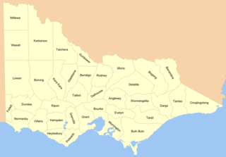
Cadastral divisions in Victoria are called counties, which are further subdivided into parishes and townships, for cadastral or land administration purposes. Cadastral divisions of county, parish and township form the basis for formal identification of the location of any piece of land in the state. There are 37 counties and 2004 parishes and 909 townships. Parishes were subdivided into sections of various sizes for sale as farming allotments, or designated as a town and then divided into sections and these subdivided into crown allotments. However, many parishes do not follow county borders, some being located in more than one county.

<span class="mw-page-title-main">History of British Columbia</span>

The history of British Columbia covers the period from the arrival of Paleo-Indians thousands of years ago to the present day. Prior to European colonization, the lands encompassing present-day British Columbia were inhabited for millennia by a number of First Nations.

<span class="mw-page-title-main">Cadastre</span> Comprehensive register of the real estate or real propertys metes-and-bounds of a country

A cadastre or cadaster is a comprehensive recording of the real estate or real property's metes-and-bounds of a country. Often it is represented graphically in a cadastral map.

<span class="mw-page-title-main">Colony of British Columbia (1866–1871)</span> British possession in North America between 1866–1871

The Colony of British Columbia was a British Crown Colony that resulted from the amalgamation of the two former colonies, the Colony of Vancouver Island and the mainland Colony of British Columbia. The two former colonies were united in 1866, and the united colony existed until its incorporation into the Canadian Confederation in 1871.

<span class="mw-page-title-main">Colony of British Columbia (1858–1866)</span> British crown colony in North America

The Colony of British Columbia was a crown colony in British North America from 1858 until 1866 that was founded by Richard Clement Moody, who was selected to 'found a second England on the shores of the Pacific', who was Chief Commissioner of Lands and Works for British Columbia and the first Lieutenant-Governor of British Columbia. Prior to the arrival of Moody's Royal Engineers, Columbia Detachment, the Colony's supreme authority was its Governor James Douglas, who was the Governor of the neighbouring colony of Vancouver Island.

<span class="mw-page-title-main">Lands administrative divisions of Australia</span> Cadastral divisions of Australia for land identification purposes

Lands administrative divisions of Australia are the cadastral divisions of Australia for the purposes of identification of land to ensure security of land ownership. Most states term these divisions as counties, parishes, hundreds, and other terms. The eastern states of Queensland, New South Wales, Victoria, and Tasmania were divided into counties and parishes in the 19th century, although the Tasmanian counties were renamed land districts in the 20th century. Parts of South Australia (south-east) and Western Australia (south-west) were similarly divided into counties, and there were also five counties in a small part of the Northern Territory. However South Australia has subdivisions of hundreds instead of parishes, along with the Northern Territory, which was part of South Australia when the hundreds were proclaimed. There were also formerly hundreds in Tasmania. There have been at least 600 counties, 544 hundreds and at least 15,692 parishes in Australia, but there are none of these units for most of the sparsely inhabited central and western parts of the country.

<span class="mw-page-title-main">Lands administrative divisions of South Australia</span> Administrative divisions of South Australia

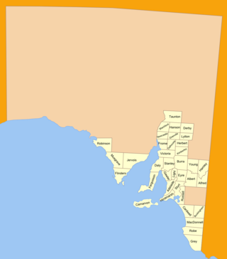
The lands administrative divisions of South Australia are the cadastral units of counties and hundreds in South Australia. They are located only in the south-eastern part of the state, and do not cover the whole state. 49 counties have been proclaimed across the southern and southeastern areas of the state historically considered to be arable and thus in need of a cadastre. Within that area, a total of 540 hundreds have been proclaimed, although five were annulled in 1870, and, in some cases, the names reused elsewhere.

The lands administrative divisions of Western Australia refer to subdivisions of the state of Western Australia for cadastral purposes, most of which have been in place since the 19th century. The state is divided up for this purpose into five land divisions, which in turn are subdivided into land districts, which correspond to counties in other Australian states. These districts are then subdivided further into numbered locations, as well as gazetted townsites. Together, they form part of the lands administrative divisions of Australia.

A cadastral community is a cadastral subdivision of municipalities in the nations of Austria, Bosnia and Herzegovina, Croatia, the Czech Republic, Serbia, Slovakia, Slovenia, the Netherlands, and the Italian provinces of South Tyrol, Trentino, Gorizia and Trieste. A cadastral community records property ownership in a cadastre, which is a register describing property ownership by boundary lines of the real estate.

<span class="mw-page-title-main">Integrated Cadastral Information Society</span>

The Integrated Cadastral Information Society is a not-for-profit organization, created as a partnership between local government, provincial government, and major utility companies in British Columbia, Canada to share and integrate spatial data.

<span class="mw-page-title-main">Outline of British Columbia</span> Province of Canada

The following outline is provided as an overview of and topical guide to British Columbia:

The New Westminster Land District is one of 59 land districts of British Columbia, Canada, which are the underlying cadastral divisions of that province, created with rest of those on Mainland British Columbia via the Lands Act of the Colony of British Columbia in 1860. The British Columbia government's BC Names system, a subdivision of GeoBC, defines a land district as "a territorial division with legally defined boundaries for administrative purposes". All land titles and surveys use the Land District system as the primary point of reference, and entries in BC Names for placenames and geographical objects are so listed.

The Osoyoos Division Yale Land District is one of the 59 land districts of British Columbia, Canada, which are the underlying cadastral divisions of that province. All land titles and surveys use the Land District system as the primary point of reference, and entries in BC Names for placenames and geographical objects are so listed.

The Cassiar Land District is a cadastral survey subdivision of the province of British Columbia, Canada, created with rest of those on Mainland British Columbia via the Lands Act of the Colony of British Columbia in 1860. The British Columbia government's BC Names system, a subdivision of GeoBC, defines a land district as "a territorial division with legally defined boundaries for administrative purposes". All land titles and surveys use the Land District system as the primary point of reference, and entries in BC Names for placenames and geographical objects are so listed.

The Comox Land District is one of the 59 land districts of British Columbia, Canada, which are part of the cadastral divisions of British Columbia, created with rest of those on Vancouver Island via the Lands Act of the Colony of Vancouver Island. The British Columbia government's BC Names system, a subdivision of GeoBC, defines a land district as "a territorial division with legally defined boundaries for administrative purposes". All land titles and surveys use the Land District system as the primary point of reference, and entries in BC Names for placenames and geographical objects are so listed.

The Lillooet Land District is one of the 59 cadastral subdivisions of British Columbia, which were created by the Lands Act of the Colony of British Columbia in 1859, defined as "a territorial division with legally defined boundaries for administrative purposes". The land district's boundaries came to be used as the boundary of the initial Lillooet riding for the provincial Legislature from 1871, when the colony became a province. In addition to use in descriptions of land titles and lot surveys, the Land District was also the basis of the Lillooet Mining District.

The Kootenay Land District is a cadastral survey subdivision of the province of British Columbia, Canada, created with rest of those on Mainland British Columbia via the Lands Act of the Colony of British Columbia in 1860. The British Columbia government's BC Names system, a subdivision of GeoBC, defines a land district as "a territorial division with legally defined boundaries for administrative purposes" All land titles and surveys use the Land District system as the primary point of reference, and entries in BC Names for placenames and geographical objects are so listed.

The Cariboo Land District is a cadastral survey subdivision of the province of British Columbia, Canada, created with rest of those on Mainland British Columbia via the Lands Act of the Colony of British Columbia in 1860. The British Columbia government's BC Names system, a subdivision of GeoBC, defines a land district as "a territorial division with legally defined boundaries for administrative purposes" All land titles and surveys use the Land District system as the primary point of reference, and entries in BC Names for placenames and geographical objects are so listed.

A land district is a type of administrative division in some countries.

The Clayoquot Land District is one of the 59 land districts of British Columbia, Canada, which are part of the cadastral divisions of British Columbia, created with rest of those on Vancouver Island via the Lands Act of the Colony of Vancouver Island. The British Columbia government's BC Names system, a subdivision of GeoBC, defines a land district as "a territorial division with legally defined boundaries for administrative purposes". All land titles and surveys use the Land District system as the primary point of reference, and entries in BC Names for placenames and geographical objects are so listed.

References

  1. https://ltsa.ca/docs/Land-Title-District-Maps.pdf [ dead link ]
  2. British Columbia Online Cadastre Archived 2009-12-08 at the Wayback Machine To use this system to view land district boundaries, pan or zoom to the approximate location, or use [Find Location] tab to pick a land district by name. Open [Layers] tab along dark blue navigation bar, then open the "Administrative Boundaries" folder and select "Land Districts (outlined)", also click "pointer" (will highlight turquoise). To substantially speed up refresh time, deselect survey parcels, cadastral fabric (etc) that might be part of the default suite; to remove the map grid, open the "Base Map" folder and deselect "Grids". Whenever you make a change to the base, scroll to bottom of folders list and [Refresh Map] or select [Automatically Refresh Map]