Smithers, British Columbia

Last updated
Smithers
Town of Smithers
SmithersBC1989.JPG
Main Street Smithers (1989)
Smithers logo.png
Canada British Columbia location map 2.svg
Red pog.svg
Smithers
Location of Smithers
Canada location map 2.svg
Red pog.svg
Smithers
Smithers (Canada)
Coordinates: 54°46′45″N127°10′34″W / 54.77917°N 127.17611°W / 54.77917; -127.17611 [1]
CountryCanada
Province British Columbia
Regional District Regional District of Bulkley-Nechako
Founded1913
Incorporated (village)1921
Incorporated (town)1967
Government
  MayorGladys Atrill
   Governing Body Smithers Town Council
   MP Taylor Bachrach (NDP)
   MLA Nathan Cullen (NDP)
Area
   Town 15.27 km2 (5.90 sq mi)
Elevation
490 m (1,631 ft)
Population
 (2016)
   Town 10,607
  Density514.9/km2 (1,334/sq mi)
   Urban
5,351 [2]
   Rural
5,256 [3]
Time zone UTC−08:00 (PST)
  Summer (DST) UTC−07:00 (PDT)
Postal code span
V0J 2N0 & V0J 3W0
Area code(s) 250, 778, 236, & 672
Demonym Smithereen
Website www.smithers.ca OOjs UI icon edit-ltr-progressive.svg

Smithers is a town in northwestern British Columbia, approximately halfway between Prince George and Prince Rupert. With a population of 5,351 in 2016, Smithers provides service coverage for most of the Bulkley Valley.

Contents

History

Region

First Nations settlements existed thousands of years prior to European presence.

Railway

The planned Grand Trunk Pacific Railway (GTP) required two major divisional points in BC, where additional staff and facilities would be located. After Prince George, various central points on the Prince Rupert leg were considered in the vicinity of Aldermere. [4] A prime choice was Hubert, 3.2 miles (5.1 km) east of Telkwa, initially called Bulkley by the developers, [5] who had amassed the surrounding land. These speculators promoted a future new city, [6] [7] and later a trade centre of the Bulkley Valley, [8] both fallacious claims, [9] since Smithers had already been selected as the divisional point. The Interior News of Aldermere had earlier adopted a policy of refusing advertising from such unscrupulous promoters. [10] The Aldermere Board of Trade was hostile to the idea of Telkwa itself being the divisional headquarters, allegedly because the rail yards would destroy the alder groves. [11] In reality, they likely foresaw that even a station would soon relocate their community down to the stop.

The speculators had not considered the swampy ground 9.2 miles (14.8 km) west of Telkwa at the foot of Hudson Bay Mountain. Averse to sharing land sale profits with speculators, the GTP made this their headquarters, creating Smithers, named after Sir Alfred Smithers, chair of the GTP board. [12] During 1913, the Railway Commission approved the station site as the second divisional point in March. [13] Surveying started in April, 100 of the 160 acres of town site were cleared by August, and 160 acres of railyards by September. The railhead advanced by in July, and the first passenger train arrived in October. [14] [15]

With the standard quarter portion reserved for government facilities, [16] the GTP began marketing plots that month. [17] [18] Despite ditches for draining, the subsoil was layers of quicksand and clay, requiring pile driving for building foundations. [19] Pleas to the GTP to address the swampy road conditions fell on deaf ears. [20]

The temporary train station, [21] built in 1915, was replaced in 1919 by a Plan 100‐166 station building. [22] For decades, the railway remained the dominant employer, but from the 1950s, employee numbers gradually dwindled, and buildings became redundant. [23] In 1994, the Smithers Community Services Association purchased [24] the listed station building. [25]

Town layout

Professional landscape architects designed the street layout [26] to accommodate a potential 10,000 people, and the municipality largely followed this plan over subsequent decades. In recent decades, expansion has adopted modern planning concepts, instead of the original grid pattern. However, the original design ignored the topography and soil conditions. Consequently, some lots on slopes, creeks or flood plains could not be developed. Main Street was the commercial core, with the train station and Alfred Park at one end and Central (formerly City Hall) Park at the other (now the intersection with Highway 16). Residential development radiated outward. In 1925, the government built a combined courthouse/provincial offices within the latter park. Main Street implemented an alpine theme in 1972. [27]

Commerce & population

The Seymour Lake Lumber Company, having a 15,000-foot capacity per shift mill, [28] was producing 10,000 feet of lumber daily to keep up with the building boom. Swampy land with canvas tents and shacks became what the Omenica Miner described in October 1913 as "the best district in British Columbia." [13]

The Telkwa Tribune, renamed the Smithers Tribune, relocated and the Smithers Review opened. [29] By 1914, there were the two newspapers, two banks, three churches, a three-storey hotel, stores, a telephone system and an electricity supply. [30] Stores and services comprised six rooming houses, five restaurants, four general stores, doctor, dentist, drugstore, hardware store, sawmill, planing mill, two lumber yards, plumber, sheet iron worker, sign works, three contracting firms, two laundries, two poolrooms, livery stable, meat market, shoe shop, and two real estate firms. [13]

After the 1914 Telkwa fire, which destroyed 13 downtown buildings, many businesses relocated to Smithers, [31] a community of 125 permanent buildings and 700 people. [32] The sizable GTP payroll provided a solid base to attract further settlers and businesses. [33] Initial optimism projected a 5,000 population by 1915, which was finally achieved in 1991. [31] The population, that fell during World War I, was 350 in 1918, and 520 in 1920. [34]

Volunteers contained two 1921 fires. The power plant one caused $10,000 damage to a cold storage plant. [35] Months later, two adjacent hotels burned to the ground. [36] By 1925, the population was about 1,000. [37] A 1930 fire caused $25,000 damage to the Hudson Bay Lumber sawmill on the western outskirts [38] A.S. Sargent permanently closed his store after a 1931 fire. [39] During the Great Depression, many businesses closed, and the population hovered around 700. [40]

From the 1940s, many small independent bush mills supplied the two local planer mills. [41] The population increased from 1,204 in 1951 to 2,487 in 1961, [42] 4,570 by 1981, and peaked at 5,624 in 1996. [43]

Public institutions & amenities

The post office completed, [44] J. Mason Adams was the inaugural postmaster 1913–14. [45] He operated the first drug store in Telkwa. [46] [47] The Smithers Citizens Association, formed in December 1913, provided leadership, but could not levy taxes. [48] Miss Mary K. Downey was the initial teacher at the school established in April 1914. In 1915, a permanent building replaced temporary accommodation in the Methodist Church. [49] Citizen donations provided a $15,000 community hall. [50] In 1920, the premier opened the two-storey hospital, which provided 15 beds on remodelling. [49] Smithers became the first incorporated village for BC in 1921. [51]

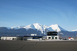
During the Depression, the basic rural road network was built, the golf course opened in 1931, the airfield in 1933, a fire truck was purchased, the Bulkley Valley District Hospital (staffed by the Sisters of St. Anne until 1969) opened in 1934, and the Dominion Experimental Farm in 1938. [52] Highway 16 was completed to Prince Rupert in 1944. A 1947 referendum approved a town water supply. [41] In 1967, when Smithers became a town, J.F. MacDonald was the first mayor. [53] The combined library/museum built that year housed the books previously shelved in the Municipal Hall garage since 1955. A decade later, the museum moved to the Central Park building, allowing the library to expand. [54] In 1976, the province moved the regional office from Prince Rupert. [43] The Bulkley Valley Regional Pool and Recreation Centre opened in 1990. [55]

Education, health & emergency services

School District 54 Bulkley Valley is one of the largest employers, and three private schools operate. [56] A Coast Mountain College campus provides tertiary education. The Smithers Public Library is open 5–9 hours daily on 6 days per week. [57] The Bulkley Valley Museum has similar restricted opening times. [58]

The Bulkley Valley Regional Pool and Recreation Centre is open daily. [59] The Bulkley Valley District Hospital is a 25-bed acute care facility. [60]

A 40-person volunteer fire department, and three-ambulance base exist. [61]

The Royal Canadian Mounted Police detachment serves Smithers, Telkwa, Fort Babine Reserve, and the Moricetown First Nations Reserve. [62]

Smithers and area now has a BC Emergency Support Services team. [63]

Transportation

Smithers Airport Cyyd22.jpg
Smithers Airport

Air Canada, Central Mountain Air, charter airlines, and helicopter companies, provide multiple daily flights.

VIA Rail's Jasper-Prince Rupert makes a scheduled stop three times a week in each direction. [64]

When Greyhound cancelled this route in 2019, BC Bus North, became the replacement operator for a twice weekly service. [65]

Culture

Smithers and the Bulkley Valley have often been described by non-residents as the somewhat culturally unique to the rest of Northern British Columbia. Many factors contribute to the composition of society in Smithers, including the arts, industry smoke stacks outside of town from mills and mining.

Smithers has adopted an alpine theme, which is drawn from the geography of the area. A town bylaw requires businesses in the downtown area centred on Main Street to construct their buildings in an alpine style. A fibreglass statue of a man blowing an alpine horn, commonly referred to as The Alpenman or Alpine Al, is located at the entrance to the main street and has become the town symbol. Similarly, the Smithers chamber of commerce displays an Alpine Al costume at community events and in television advertisements for the town's businesses.

Residents of Smithers are called Smithereens which remains a more popularly accepted demonym than the sometimes used 'Smitherite'. [66] [67]

Smithereens have a particularly strong environmental ethic. In 2006, over 600 Smithereens took to the streets to voice their opposition to a proposed coalbed methane gas field near Telkwa, which they claimed would threaten local water quality, landscape integrity and wild salmon populations.

Likewise a proposal by Thompson Creek Metals to develop a molybdenum mine to extract the Davidson deposit on Hudson Bay Mountain near the town was vigorously opposed over a period of years before TCM abandoned the project.

Smithers and the Bulkley Valley are home to many musicians, including Juno-Award-winning Alexis Puentes. The biggest assembly of musical talent happens during the annual Mid-Summer Music Festival in late June. Over the years, the Mid-Summer Music Festival has seen some famous acts like Spirit of the West and the Barenaked Ladies and has drawn audiences and participants from all across North America.

The Della Herman Theatre, named after a longtime resident and former school board official, is the primary venue for shows and performances, though several pubs and even open fields serve as secondary performance venues. Numerous organizations including the Bulkley Valley Community Arts Council operate to keep music and other artistic activities vibrant.

Demographics

In the 2021 Census of Population conducted by Statistics Canada, Smithers had a population of 5,378 living in 2,313 of its 2,411 total private dwellings, a change of

Canada 2016 Census [69]
SmithersBritish Columbia
Median age39.3 years43 years
Under 15 years old18%14.9%
Between 15 and 60 years old66.1%66.9%
65 years old and over15.8%18.3%
85 years old and over2.6%2.3%

The latest census, taken in 2016, recorded 5,351 residents in 1,435 families of an average size of 2.9 persons.

Ethnicity

Panethnic groups in the Town of Smithers (2001−2021)
Panethnic
group
2021 [70] 2016 [71] 2011 [72] 2006 [73] 2001 [74]
Pop. %Pop.%Pop.%Pop.%Pop.%
European [lower-alpha 1] 4,1854,3954,5654,1154,620
Indigenous 550555585765535
South Asian 1952525100
Southeast Asian [lower-alpha 2] 14010010510010
East Asian [lower-alpha 3] 601102010595
African 6065452560
Latin American 25200010
Middle Eastern [lower-alpha 4] 1520000
Other/Multiracial [lower-alpha 5] 02001510
Total responses5,2605,2905,3305,1455,345
Total population5,3785,4015,4045,2175,414
Note: Totals greater than 100% due to multiple origin responses

Religion

According to the 2021 census, religious groups in Smithers included: [70]

Notable residents

Hockey players

Despite its small population, Smithers has produced several notable professional ice hockey players:

Others

Twin Falls near Smithers TWIN FALLS, SMITHERS, BRITISH COLUMBIA.jpg
Twin Falls near Smithers

Recreation

Smithers is known for its world class skiing and fishing (in particular for steelhead). Other popular activities include soccer, volleyball, hockey, baseball, downhill mountain biking, cross-country skiing, hiking, quadding and snowmobiling. Smithers offers a variety of extreme sports, for example quadding in the back country, snowmobiling in the surrounding mountains, paragliding, or mountain biking down Hudson Bay Mountain. Smithers is known for its variety of recreation.

Geography

West of Smithers are Witset, New Hazelton, Kitwanga, Terrace, Kitimat, Port Edward and Prince Rupert, while to the east are Telkwa, Houston, Topley, Burns Lake, Fraser Lake, Fort Fraser, Vanderhoof and Prince George.

Climate

Smithers technically has a subarctic climate, (Dfc,) although it is on the borderline of a humid continental climate. [75] Winters are cold and cloudy but highly variable with a January average of −7.2 °C (19.0 °F). Snow is the main type of precipitation during winter. Warm spells can push temperatures above freezing during the winter months, while cold weather systems can reduce the temperature to less than −20 °C (−4 °F). The average annual snowfall is 182.7 cm (71.9 in), with maximum accumulations of snow tending to happen in February when the average snow depth is 29 cm (11 in). Summers are warm, with average highs of about 22 °C (72 °F) and an extreme high of 36.0 °C (96.8 °F). Nighttime temperatures are often cool, with normal nighttime lows under 10 °C (50 °F). Depending on the year, there may be very little or a lot of precipitation. Spring and fall are short transition seasons. Smithers receives an average of 508.5 mm (20.02 in) of precipitation a year, with February through April being the driest months. Smithers receives 1,621 hours of bright sunshine a year, ranging from a minimum of 12% of possible sunshine in December to a maximum of 47% of possible sunshine in August. [76]

Climate data for Smithers (Smithers Airport).
Climate ID: 1077500; coordinates 54°49′29″N127°10′58″W / 54.82472°N 127.18278°W / 54.82472; -127.18278 (Smithers Airport) ; elevation: 521.8 m (1,712 ft); 1981–2010 normals
MonthJanFebMarAprMayJunJulAugSepOctNovDecYear
Record high humidex 15.011.018.525.535.235.238.137.332.923.714.012.938.1
Record high °C (°F)15.6
(60.1)
11.9
(53.4)
18.9
(66.0)
25.8
(78.4)
35.8
(96.4)
34.2
(93.6)
36.0
(96.8)
35.2
(95.4)
31.1
(88.0)
24.4
(75.9)
15.6
(60.1)
13.6
(56.5)
36
(97)
Mean daily maximum °C (°F)−3.5
(25.7)
0.2
(32.4)
5.2
(41.4)
10.9
(51.6)
15.9
(60.6)
19.4
(66.9)
21.6
(70.9)
21.3
(70.3)
15.8
(60.4)
8.8
(47.8)
1.0
(33.8)
−3.6
(25.5)
9.4
(48.9)
Daily mean °C (°F)−7.2
(19.0)
−4.4
(24.1)
0.1
(32.2)
4.8
(40.6)
9.4
(48.9)
13.0
(55.4)
15.2
(59.4)
14.6
(58.3)
9.9
(49.8)
4.4
(39.9)
−2.1
(28.2)
−7.1
(19.2)
4.2
(39.6)
Mean daily minimum °C (°F)−11.0
(12.2)
−8.8
(16.2)
−4.9
(23.2)
−1.3
(29.7)
2.9
(37.2)
6.5
(43.7)
8.6
(47.5)
7.9
(46.2)
4.0
(39.2)
−0.1
(31.8)
−5.2
(22.6)
−10.7
(12.7)
−1.0
(30.2)
Record low °C (°F)−43.9
(−47.0)
−35.6
(−32.1)
−33.3
(−27.9)
−18.3
(−0.9)
−7.2
(19.0)
−4.1
(24.6)
−1.1
(30.0)
−2.2
(28.0)
−6.7
(19.9)
−22.0
(−7.6)
−32.4
(−26.3)
−39.0
(−38.2)
−43.9
(−47.0)
Record low wind chill −47−44−40−22−7−30−2−8−30−45−50−50
Average precipitation mm (inches)42.7
(1.68)
23.4
(0.92)
20.6
(0.81)
23.8
(0.94)
38.1
(1.50)
55.2
(2.17)
45.6
(1.80)
43.8
(1.72)
53.8
(2.12)
64.8
(2.55)
55.0
(2.17)
41.9
(1.65)
508.5
(20.02)
Average rainfall mm (inches)10.1
(0.40)
5.5
(0.22)
6.7
(0.26)
18.7
(0.74)
37.4
(1.47)
55.2
(2.17)
45.6
(1.80)
43.8
(1.72)
53.8
(2.12)
56.9
(2.24)
25.6
(1.01)
8.0
(0.31)
367.2
(14.46)
Average snowfall cm (inches)44.5
(17.5)
23.5
(9.3)
16.7
(6.6)
5.6
(2.2)
0.7
(0.3)
0.0
(0.0)
0.0
(0.0)
0.0
(0.0)
0.0
(0.0)
8.6
(3.4)
37.4
(14.7)
45.6
(18.0)
182.7
(71.9)
Average precipitation days (≥ 0.2 mm)16.111.210.19.611.913.512.412.313.817.316.215.4159.6
Average rainy days (≥ 0.2 mm)3.63.24.37.611.813.512.412.313.815.77.33108.4
Average snowy days (≥ 0.2 cm)14.99.77.330.500002.812.114.665
Average relative humidity (%)78.366.752.843.642.848.350.850.457.166.779.182.359.9
Mean monthly sunshine hours 42.575.8128177217.8216.6239.6217.2152.787.539.726.41,620.7
Percent possible sunshine 17.427.834.941.943.741.946.246.939.826.815.611.632.9
Source: [76]

Movies and television

Media

Television

Smithers is served by four television stations, three of which rebroadcast using transmitters owned by the Houston-Smithers Rebroadcasting Society: [77]

Call signChannelNetworkNotes
CFTK-TV-2
5 (VHF)
CTV 2 Rebroadcaster of CFTK-TV (Terrace)
CFHO-TV-2
10 (VHF)
Global Community-owned rebroadcaster of CHAN-DT (Vancouver)
CFHO-TV-1
13 (VHF)
CTV Community-owned rebroadcaster of CIVT-DT (Vancouver)
CH4441
20 (UHF)
Knowledge Network Community-owned rebroadcaster of cable-only channel

Radio

Smithers is served by six radio stations:

Call signFrequencyNameFormatNotes
CFBV
870 AM
The Moose Variety hits
CKEW-FM
88.1 FM
CBC Radio 2 Adult contemporary, public radio Community-owned rebroadcaster of CBU-FM (Vancouver)
CJFW-FM-6
92.9 FM
CJFW Country music Rebroadcaster of CJFW-FM (Terrace)
CICK-FM
93.9 FM
Smithers Community Radio Community radio
VF2169
95.1 FM
CFNR Classic rock, First Nations community radio Rebroadcaster of CFNR-FM (Terrace)
CBRS-FM
97.5 FM
CBC Radio One Public radio Rebroadcaster of CBYG-FM (Prince George)

Notes

  1. Statistic includes all persons that did not make up part of a visible minority or an indigenous identity.
  2. Statistic includes total responses of "Filipino" and "Southeast Asian" under visible minority section on census.
  3. Statistic includes total responses of "Chinese", "Korean", and "Japanese" under visible minority section on census.
  4. Statistic includes total responses of "West Asian" and "Arab" under visible minority section on census.
  5. Statistic includes total responses of "Visible minority, n.i.e." and "Multiple visible minorities" under visible minority section on census.

Related Research Articles

<span class="mw-page-title-main">Lillooet</span> District municipality in British Columbia, Canada

Lillooet is a district municipality in the Squamish-Lillooet region of southwestern British Columbia. The town is on the west shore of the Fraser River immediately north of the Seton River mouth. On BC Highway 99, the locality is by road about 100 kilometres (62 mi) northeast of Pemberton, 64 kilometres (40 mi) northwest of Lytton, and 172 kilometres (107 mi) west of Kamloops.

<span class="mw-page-title-main">Prince Rupert, British Columbia</span> City in British Columbia, Canada

Prince Rupert is a port city in the province of British Columbia, Canada. Its location is on Kaien Island near the Alaskan panhandle. It is the land, air, and water transportation hub of British Columbia's North Coast, and has a population of 12,220 people as of 2016.

<span class="mw-page-title-main">Ladysmith, British Columbia</span> Town in British Columbia, Canada

Ladysmith, originally Oyster Harbour, is a town located on the 49th parallel north on the east coast of Vancouver Island, British Columbia, Canada. The local economy is based on forestry, tourism, and agriculture. A hillside location adjacent to a sheltered harbour forms the natural geography of the community.

<span class="mw-page-title-main">Terrace, British Columbia</span> City in British Columbia, Canada

Terrace is a city in the Skeena region of west central British Columbia, Canada. This regional hub lies east of the confluence of the Kitsumkalum River into the Skeena River. On BC Highway 16, junctions branch northward for the Nisga'a Highway to the west and southward for the Stewart–Cassiar Highway to the east. The locality is by road about 204 kilometres (127 mi) southwest of Smithers and 144 kilometres (89 mi) east of Prince Rupert. Transportation links are the Northwest Regional Airport, a passenger train, and bus services.

<span class="mw-page-title-main">Merritt, British Columbia</span> City in British Columbia, Canada

Merritt is a city in the Nicola Valley of the south-central Interior of British Columbia, Canada. It is 270 km (170 mi) northeast of Vancouver. Situated at the confluence of the Nicola and Coldwater rivers, it is the first major community encountered after travelling along Phase One of the Coquihalla Highway and acts as the gateway to all other major highways to the B.C. Interior. The city developed in 1893 when part of the ranches owned by William Voght, Jesus Garcia, and John Charters were surveyed for a town site.

<span class="mw-page-title-main">Regional District of Bulkley-Nechako</span> Regional district in British Columbia, Canada

The Regional District of Bulkley–Nechako (RDBN) is a regional district in the Canadian province of British Columbia, Canada. As of the 2021 census, the population was 37,737. The area is 73,419.01 square kilometres. The regional district offices are in Burns Lake.

<span class="mw-page-title-main">Cowichan Valley Regional District</span> Regional district in British Columbia, Canada

The Cowichan Valley Regional District is a regional district in the Canadian province of British Columbia that is on the southern part of Vancouver Island, bordered by the Nanaimo and Alberni-Clayoquot Regional Districts to the north and northwest, and by the Capital Regional District to the south and east. As of the 2021 Census, the Regional District had a population of 89,013. The regional district offices are in Duncan.

<span class="mw-page-title-main">Cariboo—Prince George</span> Federal electoral district in British Columbia, Canada

Cariboo—Prince George is a federal electoral district in the province of British Columbia, Canada, that has been represented in the House of Commons of Canada since 2004.

<span class="mw-page-title-main">Prince George—Peace River—Northern Rockies</span> Federal electoral district in British Columbia, Canada

Prince George—Peace River—Northern Rockies is a federal electoral district in northern British Columbia, Canada. It has been represented in the House of Commons of Canada since 1968.

<span class="mw-page-title-main">Skeena—Bulkley Valley</span> Federal electoral district in British Columbia, Canada

Skeena—Bulkley Valley is a federal electoral district in British Columbia, Canada, that has been represented in the House of Commons of Canada since 2004.

Telkwa is a village located along British Columbia Highway 16, nearly 15 kilometres (9 mi) southeast of the town of Smithers and 350 kilometres (220 mi) west of the city of Prince George, in northwest British Columbia, Canada.

<span class="mw-page-title-main">Kitimat</span> District municipality in British Columbia, Canada

Kitimat is a district municipality in the North Coast region of British Columbia, Canada. It is a member municipality of the Regional District of Kitimat–Stikine regional government. The Kitimat Valley is part of the most populous urban district in northwest British Columbia, which includes Terrace to the north along the Skeena River Valley. The city was planned and built by the Aluminum Company of Canada (Alcan) during the 1950s. Its post office was approved on 6 June 1952.

<span class="mw-page-title-main">Port Hardy</span> District municipality in British Columbia, Canada

Port Hardy is a district municipality in British Columbia, Canada located on the north-east tip of Vancouver Island. Port Hardy has a population of 3,902 as of the 2021 census.

<span class="mw-page-title-main">Houston, British Columbia</span> District municipality in British Columbia, Canada

Houston is a forestry, mining and tourism town in the Bulkley Valley of the Northern Interior of British Columbia, Canada. Its population as of 2021 was 3,052, with approximately 2,000 in the surrounding rural area. It is known as the "steelhead capital" and it has the world's largest fly fishing rod. Houston's tourism industry is largely based on ecotourism and Steelhead Park, situated along Highway 16. Houston is named in honour of the pioneer newspaperman John Houston.

<span class="mw-page-title-main">Regional District of Fraser–Fort George</span> Regional district in British Columbia, Canada

The Regional District of Fraser–Fort George (RDFFG) is a regional district located in the Central Interior of British Columbia, Canada. It is bounded by the Alberta border to the east, the Columbia–Shuswap and Thompson–Nicola regional districts to the south and southeast, Cariboo Regional District to the southwest, the Regional District of Bulkley–Nechako to the west, and the Peace River Regional District to the north and northeast. As of the Canada 2011 Census, Fraser–Fort George had a population of 91,879 and a land area of 51,083.73 km2. The offices of the regional district are located at Prince George.

<span class="mw-page-title-main">Bulkley Valley</span> Valley in British Columbia, Canada

The Bulkley Valley is in the northwest Central Interior of British Columbia, Canada.

New Hazelton is a district municipality on the south side of the Bulkley River in the Skeena region of west central British Columbia, Canada. On BC Highway 16, the locality is by road about 68 kilometres (42 mi) northwest of Smithers and 137 kilometres (85 mi) northeast of Terrace. New Hazelton is one of the "Three Hazeltons", the other two being the original "Old" Hazelton to the northwest and South Hazelton to the west.

<span class="mw-page-title-main">Jasper–Prince Rupert train</span> Via Rail service between Jasper, Alberta and Prince Rupert, British Columbia

The Jasper–Prince Rupert train is a Canadian passenger train service operated by Via Rail between Jasper, Alberta, Prince George and Prince Rupert in British Columbia.

<span class="mw-page-title-main">South Asian Canadians in British Columbia</span>

The South Asian community in British Columbia was first established in 1897. The first immigrants originated from Punjab, British India, a northern region and state in modern-day India and Pakistan. Punjabis originally settled in rural British Columbia at the turn of the twentieth century, working in the forestry and agricultural industries.

South Hazelton is an unincorporated community in the Skeena region of west central British Columbia, Canada. The place is on the east side of the Skeena River immediately south of the Bulkley River mouth. On BC Highway 16, the locality is by road about 73 kilometres (45 mi) northwest of Smithers and 132 kilometres (82 mi) northeast of Terrace. South Hazelton is one of the "Three Hazeltons", the other two being the original "Old" Hazelton to the north and New Hazelton to the east.

References

  1. "Smithers". Geographical Names Data Base . Natural Resources Canada.
  2. "2016 Census Profile". www12.statcan.gc.ca. 8 February 2017.
  3. "2016 Census Profile". www12.statcan.gc.ca.
  4. Fort George Tribune, 23 Nov 1912
  5. Fort George Tribune, 12 Jul 1913
  6. Fort George Herald, 16 Aug 1913
  7. Fort George Tribune: 13 Sep 1913 & 4 Oct 1913
  8. Fort George Tribune: 18 Apr 1914; 20 & 27 Jun 1914; 25 Jul 1914; 7, 14, 21, & 28 Nov 1914; & 16, 23, & 30 Jan 1915
  9. Prince George Post: 21 Nov 1914 & 3 Apr 1915
  10. Fort George Herald, 1 Feb 1913
  11. Kruisselbrink 2012, pp. 59–62.
  12. Kruisselbrink 2012, pp. 58, 62–63.
  13. 1 2 3 "100 Years of Smithers Main Street". www.northword.ca.
  14. Kruisselbrink 2012, pp. 64–65.
  15. Fort George Herald, 2 Aug 1913
  16. Portage la Prairie Weekly, 20 Aug 1913
  17. The Voice, 17 Oct 1913
  18. Fort George Herald: 22 Nov 1913 & 3 Dec 1913
  19. Kruisselbrink 2012, p. 91.
  20. Kruisselbrink 2012, pp. 93–96.
  21. "Image: Smithers temporary station". www.bvmuseum.org. Archived from the original on 2019-11-10. Retrieved 2019-12-21.
  22. Bohi, Charles W.; Kozma, Leslie S. (2002). Canadian National's Western Stations. Fitzhenry & Whiteside. pp.  122 & 138. ISBN   1550416324.
  23. Kruisselbrink 2012, pp. 113–114.
  24. Kruisselbrink 2012, p. 116.
  25. "Canada's Historic Places, Smithers". www.historicplaces.ca.
  26. The Winnipeg Tribune, 21 Jun 1913
  27. Kruisselbrink 2012, pp. 97–98.
  28. Fort George Herald, 6 Sep 1913
  29. Fort George Herald, 8 Nov 1913
  30. Kruisselbrink 2012, p. 89.
  31. 1 2 Kruisselbrink 2012, p. 100.
  32. Kruisselbrink 2012, p. 90.
  33. Kruisselbrink 2012, pp. 96–97.
  34. Kruisselbrink 2012, pp. 102–103.
  35. Prince George Citizen, 24 Jun 1921
  36. Prince George Citizen, 27 Sep 1921
  37. Kruisselbrink 2012, p. 109.
  38. Prince George Citizen, 17 Jul 1930
  39. Prince George Citizen, 15 Jan 1931
  40. Kruisselbrink 2012, pp. 109–110.
  41. 1 2 Kruisselbrink 2012, p. 111.
  42. Kruisselbrink 2012, p. 112.
  43. 1 2 Kruisselbrink 2012, p. 156.
  44. Fort George Herald, 18 Oct 1913
  45. "Postmasters". www.bac-lac.gc.ca.
  46. "Telkwa history". www.gent.ca.
  47. "Smithers history". www.gent.ca.
  48. Kruisselbrink 2012, pp. 93, 101–102.
  49. 1 2 Kruisselbrink 2012, p. 101.
  50. Kruisselbrink 2012, pp. 104 & 108.
  51. Kruisselbrink 2012, p. 105.
  52. Kruisselbrink 2012, p. 110.
  53. Kruisselbrink 2012, p. 154.
  54. "Smithers Public Library history". Archived from the original on 2019-04-02.
  55. "Bulkley Valley Pool". www.bvpool.com.
  56. Smithers 2008, p. 22.
  57. "Smithers Public Library". www.smithers.bc.libraries.coop.
  58. "Bulkley Valley Museum". www.bvmuseum.org.
  59. "Bulkley Valley Pool". www.bvpool.com.
  60. Smithers 2008, p. 44.
  61. Smithers 2008, p. 42.
  62. "Smithers RCMP". www.rcmp-grc.gc.ca. 14 July 2015.
  63. "BC ESS Website".
  64. "Smithers station". www.viarail.ca.
  65. "Bus schedule". www.bcbus.ca.
  66. Kruisselbrink 2012, p. 97.
  67. Gareau, Chris (12 December 2012). "Cummins shares plans to improve B.C. budget with Smithereens". The Interior News. Retrieved 27 November 2017.
  68. "Population and dwelling counts: Canada, provinces and territories, and census subdivisions (municipalities), British Columbia". Statistics Canada. February 9, 2022. Retrieved February 20, 2022.
  69. Statistics Canada, Community Highlights for Smithers [ permanent dead link ], 2001 Community Profiles, October 23, 2007.
  70. 1 2 Government of Canada, Statistics Canada (2022-10-26). "Census Profile, 2021 Census of Population". www12.statcan.gc.ca. Retrieved 2022-11-11.
  71. Government of Canada, Statistics Canada (2021-10-27). "Census Profile, 2016 Census". www12.statcan.gc.ca. Retrieved 2023-03-13.
  72. Government of Canada, Statistics Canada (2015-11-27). "NHS Profile". www12.statcan.gc.ca. Retrieved 2023-03-13.
  73. Government of Canada, Statistics Canada (2019-08-20). "2006 Community Profiles". www12.statcan.gc.ca. Retrieved 2023-03-13.
  74. Government of Canada, Statistics Canada (2019-07-02). "2001 Community Profiles". www12.statcan.gc.ca. Retrieved 2023-03-13.
  75. "Climatic Regions [Köppen]". Atlas of Canada. Natural Resources Canada. June 2003. Archived from the original on April 3, 2012. Retrieved December 24, 2012.
  76. 1 2 "Canadian Climate Normals 1981-2010 Station Data - Climate - Environment and Climate Change Canada". Environment Canada. Retrieved July 15, 2018.
  77. "About Us". Houston-Smithers Rebroadcasting Society. Retrieved 31 August 2015.