Vanderhoof, British Columbia

Last updated

Vanderhoof
District of Vanderhoof [1]
Vanderhoof BC's welcome sign.jpg
Canada British Columbia location map 2.svg
Red pog.svg
Vanderhoof
Location of Vanderhoof in British Columbia
Coordinates: 54°00′52″N124°00′32″W / 54.01444°N 124.00889°W / 54.01444; -124.00889
CountryCanada
Province British Columbia
Region Interior Plateau
Regional district Regional District of Bulkley-Nechako
Incorporated1926
Government
[2]
  MayorKevin Moutray
  Chief Administrative OfficerGerald Pinchback
Area
  Total54.83 km2 (21.17 sq mi)
Elevation
640 m (2,100 ft)
Population
 (2016)
  Total4,439
  Density81.0/km2 (210/sq mi)
Time zone UTC-8 (PST)
  Summer (DST) UTC-7 (PDT)
Area code 250 / 778 / 236
Highways BC-16 (TCH).svg Hwy 16 (TCH) Trans-Canada Highway
BC-27.svg Hwy 27
Waterways Nechako River
Climate Dfb
Website www.vanderhoof.ca OOjs UI icon edit-ltr-progressive.svg

Vanderhoof is a district municipality near the geographical centre [3] of British Columbia, Canada. Covering 2.92 square kilometers, [4] it has a population of about 4,500 within town limits, and offers services to nearly 10,000 people in nearby rural communities. Its main industries are forestry, agriculture, and related businesses. Tourism is also growing, and mining operations are being developed in the area. It has many elementary schools, and one major secondary school, Nechako Valley Secondary School (NVSS), comprising School District 91 Nechako Lakes. The College of New Caledonia has a regional campus there.

Contents

Via Rail's Jasper–Prince Rupert train serves the Vanderhoof railway station.

History

The municipality is named after Herbert Vanderhoof of Chicago, one of its founders. He was an employee of the Grand Trunk Pacific Development Company, a subsidiary of Grand Trunk Pacific Railway. [5] [6] [7] The municipality's population rapidly expanded until World War II, when many of the town's men left to fight overseas. After the war, an increase in lumber prices and the construction of the Kenney Dam lead to increases in population again. Today Vanderhoof is a service centre in the eastern Bulkley-Nechako for surrounding communities, and the second-largest municipality in the regional district. [8]

Demographics

In the 2021 Census of Population conducted by Statistics Canada, Vanderhoof had a population of 4,346 living in 1,786 of its 1,885 total private dwellings, a change of

Ethnicity

Panethnic groups in the District of Vanderhoof (1981−2021)
Panethnic
group
2021 [10] 2016 [11] 2011 [12] 2006 [13] 2001 [14] 1996 [15] 1991 [16] [17] 1986 [18] [19] [20] :1111981 [21] [22]
Pop. %Pop.%Pop.%Pop.%Pop.%Pop.%Pop.%Pop.%Pop.%
European [lower-alpha 1] 3,5003,6653,7403,5503,9154,0503,5103,0552,300
Indigenous 480460485280230160325290170
Southeast Asian [lower-alpha 2] 1159035750005
South Asian 705075351309512070110
African 40151565030150
Latin American 251000100000
East Asian [lower-alpha 3] 152010304515153050
Middle Eastern [lower-alpha 4] 0002000000
Other/Multiracial [lower-alpha 5] 251001000
Total responses4,2854,3054,3704,0604,3254,3603,9853,4502,630
Total population4,3464,4344,4804,0644,3904,4014,0233,5052,323
Note: Totals greater than 100% due to multiple origin responses

Religion

According to the 2021 census, religious groups in Vanderhoof included: [10]

Wildlife

Vanderhoof is known for its bird sanctuary along the Nechako River. Many Canada geese, swans, and other migratory birds pass through Vanderhoof during their annual migrations. The Nechako is home to a number of fish species, including salmon and the endangered Nechako white sturgeon. Many hunters come to Vanderhoof in search of bear, moose, deer, cougar and elk.

Schools

Elementary:
Evelyn Dickson
W.L. McLeod
Sinkutview
Mapes

Secondary:
Nechako Valley Secondary School (NVSS
Northside Christian School
Valhalla High Virtual School: EBUS Academy

Culture and recreation

A collaborative mural painted on the Neighbourhood Space Youth Centre in 2010. Street Art, Vanderhoof, British Columbia, Canada 1.jpg
A collaborative mural painted on the Neighbourhood Space Youth Centre in 2010.

Telegraph Trail

A telegraph line, set up in the 1890s for communication with the Klondike Gold Rush gold fields, was abandoned in the 1930s and later converted into a series of walking trails. A 10 km trail connects Hogsback Lake (near Vanderhoof) to Blackwater Road.

Community events

Climate

Vanderhoof has a humid continental climate (Köppen Dfb) with mild summers and cold winters.

Climate data for Vanderhoof, 1981–2010 normals, extremes 1916–present
MonthJanFebMarAprMayJunJulAugSepOctNovDecYear
Record high °C (°F)13.0
(55.4)
16.7
(62.1)
20.0
(68.0)
28.9
(84.0)
36.0
(96.8)
33.9
(93.0)
35.0
(95.0)
35.5
(95.9)
33.0
(91.4)
28.0
(82.4)
17.5
(63.5)
12.5
(54.5)
36.0
(96.8)
Mean daily maximum °C (°F)−4.5
(23.9)
−0.1
(31.8)
5.9
(42.6)
12.4
(54.3)
17.8
(64.0)
21.3
(70.3)
23.5
(74.3)
23.3
(73.9)
17.9
(64.2)
10.3
(50.5)
0.9
(33.6)
−4.1
(24.6)
10.4
(50.7)
Daily mean °C (°F)−9.0
(15.8)
−5.5
(22.1)
−0.2
(31.6)
5.6
(42.1)
10.7
(51.3)
14.4
(57.9)
16.3
(61.3)
15.9
(60.6)
11.0
(51.8)
5.0
(41.0)
−2.8
(27.0)
−8.1
(17.4)
4.4
(39.9)
Mean daily minimum °C (°F)−13.3
(8.1)
−10.9
(12.4)
−6.3
(20.7)
−1.3
(29.7)
3.5
(38.3)
7.4
(45.3)
9.1
(48.4)
8.3
(46.9)
4.1
(39.4)
−0.3
(31.5)
−6.5
(20.3)
−12.1
(10.2)
−1.5
(29.3)
Record low °C (°F)−51.7
(−61.1)
−51.1
(−60.0)
−42.8
(−45.0)
−29.4
(−20.9)
−9.4
(15.1)
−6.7
(19.9)
−3.3
(26.1)
−5.0
(23.0)
−16.7
(1.9)
−28.0
(−18.4)
−42.2
(−44.0)
−50.6
(−59.1)
−51.7
(−61.1)
Average precipitation mm (inches)44.4
(1.75)
26.6
(1.05)
24.4
(0.96)
25.4
(1.00)
34.7
(1.37)
57.0
(2.24)
52.4
(2.06)
43.1
(1.70)
44.3
(1.74)
50.8
(2.00)
45.1
(1.78)
41.3
(1.63)
489.2
(19.26)
Average rainfall mm (inches)6.6
(0.26)
5.4
(0.21)
7.1
(0.28)
19.4
(0.76)
34.2
(1.35)
56.8
(2.24)
52.3
(2.06)
43.1
(1.70)
44.0
(1.73)
43.3
(1.70)
16.1
(0.63)
3.8
(0.15)
332.0
(13.07)
Average snowfall cm (inches)37.8
(14.9)
21.3
(8.4)
17.3
(6.8)
6.0
(2.4)
0.5
(0.2)
0.2
(0.1)
0.0
(0.0)
0.0
(0.0)
0.2
(0.1)
7.5
(3.0)
29.0
(11.4)
37.5
(14.8)
157.2
(61.9)
Average precipitation days (≥ 0.2 mm)14.19.510.09.712.614.113.812.513.016.314.511.8152.1
Average rainy days (≥ 0.2 mm)2.92.85.08.012.514.113.812.512.914.76.42.0107.7
Average snowy days (≥ 0.2 cm)12.17.26.02.50.40.00.00.00.22.710.110.351.4
Source: Environment Canada [25] [26] [27] [28]

See also

Notes

  1. Statistic includes all persons that did not make up part of a visible minority or an indigenous identity.
  2. Statistic includes total responses of "Filipino" and "Southeast Asian" under visible minority section on census.
  3. Statistic includes total responses of "Chinese", "Korean", and "Japanese" under visible minority section on census.
  4. Statistic includes total responses of "West Asian" and "Arab" under visible minority section on census.
  5. Statistic includes total responses of "Visible minority, n.i.e." and "Multiple visible minorities" under visible minority section on census.

Related Research Articles

<span class="mw-page-title-main">Ladysmith, British Columbia</span> Town in British Columbia, Canada

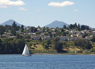
Ladysmith, originally Oyster Harbour, is a town located on the 49th parallel north on the east coast of Vancouver Island, British Columbia, Canada. The local economy is based on forestry, tourism, and agriculture. A hillside location adjacent to a sheltered harbour forms the natural geography of the community.

<span class="mw-page-title-main">Sparwood</span> District municipality in British Columbia, Canada

Sparwood is a district municipality in the Canadian province of British Columbia. It is the second-largest community on the Elk River.

<span class="mw-page-title-main">Golden, British Columbia</span> Town in British Columbia, Canada

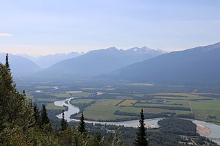
Golden is a town in southeastern British Columbia, Canada, 262 kilometres (163 mi) west of Calgary, Alberta, and 713 kilometres (443 mi) east of Vancouver.

<span class="mw-page-title-main">Regional District of Bulkley-Nechako</span> Regional district in British Columbia, Canada

The Regional District of Bulkley–Nechako (RDBN) is a regional district in the Canadian province of British Columbia, Canada. As of the 2021 census, the population was 37,737. The area is 73,419.01 square kilometres. The regional district offices are in Burns Lake.

<span class="mw-page-title-main">Municipality of the District of Lunenburg</span> District municipality in Nova Scotia, Canada

The Municipality of the District of Lunenburg, is a district municipality in Lunenburg County, Nova Scotia, Canada. Statistics Canada classifies the district municipality as a municipal district.

<span class="mw-page-title-main">North Cowichan</span> District municipality in British Columbia, Canada

North Cowichan is a district municipality established in 1873 on Vancouver Island, in British Columbia, Canada. The municipality is part of the Cowichan Valley Regional District. North Cowichan is noted for a landscape including forests, beaches, rivers, and lakes. The municipality encompasses the communities of Chemainus; Westholme; Crofton; Maple Bay; and "the South End". The latter is an informal name for a built-up area which is essentially a suburb of the City of Duncan, a separate municipality.

<span class="mw-page-title-main">Kimberley, British Columbia</span> City in British Columbia, Canada

Kimberley is a city in southeast British Columbia, Canada along Highway 95A between the Purcell and Rocky Mountains. Kimberley was named in 1896 after the Kimberley mine in South Africa. From 1917 to 2001, it was the home to the world's largest lead-zinc mine, the Sullivan Mine. Now it is mainly a tourist destination and home to the Kimberley Alpine Resort, a ski area and Kimberley's Underground Mining Railway that features a 750-foot-long (230 m) underground mining interpretive centre complete with operational 3 ft narrow-gauge railway equipment. Recreational pursuits include world-class skiing, snowboarding, snowmobiling, fishing, whitewater rafting, kayaking, biking, hiking and golfing on championship golf courses. The city has the largest urban park in Canada. At 1,977 acres (800 ha), the Kimberley Nature Park is the largest incorporated park in Canada.

<span class="mw-page-title-main">Central Saanich</span> District municipality in British Columbia, Canada

Central Saanich is a district municipality in Greater Victoria, British Columbia, Canada, and a member municipality of the Capital Regional District. It is located on the Saanich Peninsula, in the far south-east of Vancouver Island. It is the traditional territory of the W̱SÁNEĆ people. The district began as a farming community, and many hobby farms, along working farms and vineyards, still exist. In recent decades, the area has seen increasing residential, commercial, and industrial development, especially around the neighbourhoods of Brentwood Bay and Saanichton, which are occasionally referred to as separate communities.

The District of Metchosin is a municipality and community in Greater Victoria on the southern tip of Vancouver Island in British Columbia, Canada. It is a coastal community adjacent to the Strait of Juan de Fuca. Metchosin is part of the Western Communities and one of the 13 regional municipalities.

<span class="mw-page-title-main">Cowichan Valley Regional District</span> Regional district in British Columbia, Canada

The Cowichan Valley Regional District is a regional district in the Canadian province of British Columbia that is on the southern part of Vancouver Island, bordered by the Nanaimo and Alberni-Clayoquot Regional Districts to the north and northwest, and by the Capital Regional District to the south and east. As of the 2021 Census, the Regional District had a population of 89,013. The regional district offices are in Duncan.

<span class="mw-page-title-main">Mackenzie, British Columbia</span> District municipality in British Columbia, Canada

Mackenzie is a district municipality within the Fraser-Fort George Regional District in central British Columbia, Canada. The community is located at the south end of Williston Lake. The townsite, established by Alexandra Forest Industries and Cattermole Timber, was named for Sir Alexander MacKenzie (1764–1820).

<span class="mw-page-title-main">Kitimat</span> District municipality in British Columbia, Canada

Kitimat is a district municipality in the North Coast region of British Columbia, Canada. It is a member municipality of the Regional District of Kitimat–Stikine regional government. The Kitimat Valley is part of the most populous urban district in northwest British Columbia, which includes Terrace to the north along the Skeena River Valley. The city was planned and built by the Aluminum Company of Canada (Alcan) during the 1950s. Its post office was approved on 6 June 1952.

<span class="mw-page-title-main">Port Hardy</span> District municipality in British Columbia, Canada

Port Hardy is a district municipality in British Columbia, Canada located on the north-east tip of Vancouver Island. Port Hardy has a population of 3,902 as of the 2021 census.

<span class="mw-page-title-main">Houston, British Columbia</span> District municipality in British Columbia, Canada

Houston is a forestry, mining and tourism town in the Bulkley Valley of the Northern Interior of British Columbia, Canada. Its population as of 2021 was 3,052, with approximately 2,000 in the surrounding rural area. It is known as the "steelhead capital" and it has the world's largest fly fishing rod. Houston's tourism industry is largely based on ecotourism and Steelhead Park, situated along Highway 16. Houston is named in honour of the pioneer newspaperman John Houston.

<span class="mw-page-title-main">Regional District of Fraser–Fort George</span> Regional district in British Columbia, Canada

The Regional District of Fraser–Fort George (RDFFG) is a regional district located in the Central Interior of British Columbia, Canada. It is bounded by the Alberta border to the east, the Columbia–Shuswap and Thompson–Nicola regional districts to the south and southeast, Cariboo Regional District to the southwest, the Regional District of Bulkley–Nechako to the west, and the Peace River Regional District to the north and northeast. As of the Canada 2011 Census, Fraser–Fort George had a population of 91,879 and a land area of 51,083.73 km2. The offices of the regional district are located at Prince George.

The demographics of Metro Vancouver indicate a multicultural and multiracial region. Metro Vancouver is a metropolitan area, with its major urban centre being Vancouver, British Columbia, Canada. The Vancouver census metropolitan area, as defined by Statistics Canada, encompasses roughly the same territory as the Metro Vancouver Regional District, a regional district in British Columbia. The regional district includes 23 local authorities. Figures provided here are for the Vancouver census metropolitan area and not for the City of Vancouver.

Lake Cowichan is a town located on the east end of Cowichan Lake and, by highway, is 27 kilometres (17 mi) west of Duncan, British Columbia. The town of Lake Cowichan was incorporated in 1944. The Cowichan River flows through the middle of the town. Cowichan River is designated as a Heritage River.

According to the 2021 census, the City of Edmonton had a population of 1,010,899 residents, compared to 4,262,635 for all of Alberta, Canada. The total population of the Edmonton census metropolitan area (CMA) was 1,418,118, making it the sixth-largest CMA in Canada.

<span class="mw-page-title-main">Fort St. James</span> District municipality in British Columbia, Canada

Fort St. James is a district municipality and former fur trading post in northern central British Columbia, Canada. It is located on the south-eastern shore of Stuart Lake in the Omineca Country, at the northern terminus of Highway 27, which connects to Highway 16 at Vanderhoof.

<span class="mw-page-title-main">Demographics of Calgary</span>

In the 2021 Census, the City of Calgary had a population of 1,306,784 residents, representing 30.7% of the 4,262,635 residents in all of Alberta, and 3.5% compared to a population of 36,991,981 in all of Canada. The total population of the Calgary census metropolitan area (CMA) was 1,481,806. Calgary is the largest city in Alberta, and the third-largest municipality and fifth-largest metropolitan area in Canada, as of 2021.

References

  1. "British Columbia Regional Districts, Municipalities, Corporate Name, Date of Incorporation and Postal Address" (XLS). British Columbia Ministry of Communities, Sport and Cultural Development. Retrieved 2 November 2014.
  2. District of Vanderhoof. Mayor and Councillors
  3. "Vanderhoof". Official Travel Website of British Columbia. Archived from the original on 27 September 2011. Retrieved 30 October 2006.
  4. "Census Profile, 2016 Census - Vanderhoof [Population centre], British Columbia and British Columbia [Province]". 8 February 2017.
  5. Carla Funk (2 November 2019). "The small towns that make Canadian literature unique". Globe and Mail . Retrieved 28 August 2020. The town took its name from Herbert Vanderhoof, who envisioned the place as a colony for artists and writers. His dream never took quite took shape, but the town grew and the name stuck.
  6. "Vanderhoof". BC Geographical Names. Retrieved 17 January 2019.
  7. "Grand Trunk Pacific Development Company Limited". memorybc.ca. Retrieved 18 December 2020.
  8. "Vanderhoof". The Canadian Encyclopedia. Historica Canada. Retrieved 18 December 2020.
  9. "Population and dwelling counts: Canada, provinces and territories, and census subdivisions (municipalities), British Columbia". Statistics Canada. 9 February 2022. Retrieved 20 February 2022.
  10. 1 2 Government of Canada, Statistics Canada (26 October 2022). "Census Profile, 2021 Census of Population". www12.statcan.gc.ca. Retrieved 11 November 2022.
  11. Government of Canada, Statistics Canada (27 October 2021). "Census Profile, 2016 Census". www12.statcan.gc.ca. Retrieved 16 March 2023.
  12. Government of Canada, Statistics Canada (27 November 2015). "NHS Profile". www12.statcan.gc.ca. Retrieved 16 March 2023.
  13. Government of Canada, Statistics Canada (20 August 2019). "2006 Community Profiles". www12.statcan.gc.ca. Retrieved 16 March 2023.
  14. Government of Canada, Statistics Canada (2 July 2019). "2001 Community Profiles". www12.statcan.gc.ca. Retrieved 16 March 2023.
  15. Government of Canada, Statistics Canada (4 June 2019). "Electronic Area Profiles Profile of Census Divisions and Subdivisions, 1996 Census". www12.statcan.gc.ca. Retrieved 16 March 2023.
  16. Government of Canada, Statistics Canada (29 March 2019). "1991 Census Area Profiles Profile of Census Divisions and Subdivisions - Part B". www12.statcan.gc.ca. Retrieved 16 March 2023.
  17. Government of Canada, Statistics Canada (29 March 2019). "Data tables, 1991 Census Population by Ethnic Origin (24), Showing Single and Multiple Origins (2) - Canada, provinces and territories, census divisions and census subdivisions". www12.statcan.gc.ca. Retrieved 16 March 2023.
  18. Government of Canada, Statistics Canada (27 June 2019). "Data tables, 1986 Census Census Profile for Canada, Provinces and Territories, Census Divisions and Census Subdivisions, 1986 Census - Part A". www12.statcan.gc.ca. Retrieved 16 March 2023.
  19. Government of Canada, Statistics Canada (27 June 2019). "Data tables, 1986 Census Census Profile for Canada, Provinces and Territories, Census Divisions and Census Subdivisions, 1986 Census - Part B". www12.statcan.gc.ca. Retrieved 16 March 2023.
  20. Government of Canada, Statistics Canada (3 April 2013). "Canada's aboriginal population by census subdivisions from the 1986 Census of Canada". www12.statcan.gc.ca. Retrieved 16 March 2023.
  21. Government of Canada, Statistics Canada (26 May 2020). "Data tables, 1981 Census Profile for Canada, Provinces and Territories, Census Divisions and Census Subdivisions, 1981 Census - Part A". www12.statcan.gc.ca. Retrieved 22 March 2023.
  22. Government of Canada, Statistics Canada (26 May 2020). "Data tables, 1981 Census Profile for Canada, Provinces and Territories, Census Divisions and Census Subdivisions, 1981 Census - Part B". www12.statcan.gc.ca. Retrieved 22 March 2023.
  23. "Mural". Good Neighbours Committee.
  24. "Diversity Mural". Annerose Georgeson.
  25. "Calculation Information for 1981 to 2010 Canadian Normals Data". Environment Canada. 25 September 2013. Retrieved 4 March 2017.
  26. "Vanderhoof". Environment Canada. 31 October 2011. Retrieved 4 March 2017.
  27. "Vanderhoof Braeside Rd". Environment Canada. 31 October 2011. Retrieved 4 March 2017.
  28. "Vanderhoof BC". Environment Canada. 31 October 2011. Retrieved 4 March 2017.