Sidney, British Columbia

Last updated

Sidney
Town of Sidney [1]
1936 Post Office Building, Sidney, BC.jpg
Sidney Post Office
24 Capital Regional District British Columbia.svg
Western Canada Map Assets Town.svg
Sidney
Location of Sidney within the Capital Regional District
Canada Vancouver Island location map.svg
Red pog.svg
Sidney
Location of Town of Sidney within the Capital District in British Columbia, Canada
Canada British Columbia location map 2.svg
Red pog.svg
Sidney
Sidney (British Columbia)
Coordinates: 48°39′2″N123°23′55″W / 48.65056°N 123.39861°W / 48.65056; -123.39861
CountryCanada
Province British Columbia
Regional district Capital
Incorporated1952
Government
  Governing bodySidney Town Council
  MayorCliff McNeil-Smith [2]
   MP Elizabeth May (Green)
   MLA Adam Olsen (Green)
Area
[3]
  Total5.10 km2 (1.97 sq mi)
Elevation
5 m (16 ft)
Population
 (2016) [3]
  Total11,672
  Density2,290.7/km2 (5,933/sq mi)
Time zone UTC-8 (PST)
Forward sortation area
V8L
Area code(s) 250, 778
Highways 17
Waterways Haro Strait
Website www.sidney.ca OOjs UI icon edit-ltr-progressive.svg
Typical condominium architecture in Sidney. Sidneycond.JPG
Typical condominium architecture in Sidney.
This single-family house in Sidney features a collection of palms, including Chinese windmill palm. SeveralSidneypalms.JPG
This single-family house in Sidney features a collection of palms, including Chinese windmill palm.

Sidney is a town located at the northern end of the Saanich Peninsula, on Vancouver Island in the province of British Columbia. It's one of the thirteen Greater Victoria municipalities. It has a population of approximately 11,583. Sidney is located just east of Victoria International Airport, and about 6 km (4 mi) south of BC Ferries' Swartz Bay Terminal. The town is also the only Canadian port-of-call in the Washington State Ferries system, with ferries running from Sidney to the San Juan Islands and Anacortes. Sidney is located along Highway 17, which bisects the town from north to south. It is generally considered part of the Victoria metropolitan area.

Contents

The town west of Highway 17 (also called Patricia Bay Highway, locally abbreviated as the Pat Bay Highway) has a mixture of single-family residences and light industry. The majority of the town is located east of Highway 17. Single-family units are also present east of the highway, but the eastern sector also has many condominium-type buildings, plus most of the service and retail outlets. The island-studded Haro Strait, part of the Salish Sea, forms Sidney's eastern boundary. There is a large boating and marine industry in the area, ranging from marinas to boatbuilders and marine suppliers.

Sidney takes its name from nearby Sidney Island. In 1859, Captain Richards named that island for Frederick W. Sidney, who, like Richards served in the survey branch of the Royal Navy. [4] :243

Demographics

In the 2021 Census of Population conducted by Statistics Canada, Sidney had a population of 12,318 living in 5,981 of its 6,321 total private dwellings, a change of

Sidney has a median age of 60.4 [6] in 2001 as compared with the British Columbia median age of 38.4. Sidney had more than 35% of their population over the age of 65.

Ethnicity

Panethnic groups in the Town of Sidney (2001−2021)
Panethnic
group
2021 [7] 2016 [8] 2011 [9] 2006 [10] 2001 [11]
Pop. %Pop.%Pop.%Pop.%Pop.%
European [lower-alpha 1] 10,33510,0709,92510,35010,005
Southeast Asian [lower-alpha 2] 48533517535130
Indigenous 395360230250195
East Asian [lower-alpha 3] 245140180155170
South Asian 14090706540
African 6045152055
Latin American 6025404520
Middle Eastern [lower-alpha 4] 0101500
Other/Multiracial [lower-alpha 5] 554507510
Total responses11,78011,12510,65511,01010,625
Total population12,31811,67211,17811,31510,929
Note: Totals greater than 100% due to multiple origin responses

Religion

According to the 2021 census, religious groups in Sidney included: [7]

Labour force

Sidney is mainly an industrial town, with most people working in the construction, manufacturing, and warehousing fields (26%). Retail accounts for approximately 10% of the employment. Healthcare and social assistance employs 13%. There are over 4,000 people employed in Sidney, with an unemployment rate of 6.1%. It should also be taken into consideration that some of this labour force commutes from neighbouring municipalities, such as Saanich or Victoria. The median income is $24,638. The median income for a household in the town is $63,840 [6] Renting costs in Sidney have increased substantially over the past few years, with a Standard 2 Bedroom Suite reaching as much as $2500 a month. The average cost of a house in Sidney in March 2019 was $645,500. [12]

Government

The Town of Sidney is a municipality governed by an elected Council. The elected Council, 2015–2018 consists of one Mayor and six Councillors. Mayor Steve Price, Councillor Erin Bremner-Mitchell, Councillor Tim Chad, Councillor Barbara Fallot, Councillor Mervyn Lougher-Goodey, Councillor Cam McLennan, and Councillor Peter Wainwright.

Education

Public schools serving Sidney residents are operated by School District 63 Saanich. These include Sidney Elementary School, North Saanich Middle School, and Parkland Secondary School.

Sister city

On June 30, 2008, the Sidney Sister Cities Association and the town of Sidney, BC declared the twinning of Sidney and Niimi, Okayama, Japan. This was Sidney's third sister city, following Cairns, Queensland, Australia and Anacortes, Washington, United States.

Attractions

Sidney's most popular attraction is its position on the Salish Sea. Sidney-by-the-Sea is the gateway to the southern Gulf Islands National Park Reserve, and is an eco-tourist destination, with whale-watching, bird-watching, kayaking and scuba-diving. It is home to the new Shaw Ocean Discovery Centre. Shoal Harbour Migratory Bird Sanctuary is located within Sidney and the adjoining Sidney Channel Important Bird Area, an internationally recognized site important to a variety of seabirds and waterfowl.

Sidney has its own local history museum, the Sidney Museum and Archives, which features displays about the history of the surrounding Peninsula as well as temporary exhibits. As home to the Victoria International Airport Sidney also hosts the British Columbia Aviation Museum which features displays, artifacts, restored historical aircraft and a vintage aircraft restoration workshop.[ citation needed ]

During the summer, Sidney hosts a street market on Thursday evenings on the main street (Beacon). "Sidney days" is another event that occurs at the beginning of July. To celebrate, Sidney has a parade, a build-a-boat contest, [13] a small fair and fireworks in the evening. In the winter, Sidney has a holiday parade as well as a lighted sailpast boat parade. Sidney has many dining places including Greek, Thai, Chinese, Japanese, and west-coast restaurants. With 12 bookstores, Sidney is officially one of Canada's 2 book towns, the other being Fundy-St. Martins, New Brunswick. It also has almost as many coffee joints and cafes to sit and read in.

Physiography

Maintenance of drainage systems is essential in the heavy clay soils which underlie most of Sidney. SidneyClay.JPG
Maintenance of drainage systems is essential in the heavy clay soils which underlie most of Sidney.

Almost all of the land within Sidney's boundary is either flat or very gently sloping, providing a topography which is favourable for the town's elderly people. Most soils are clayey, and poorly drained in their natural state. In some parts of town, this clay is overlain by deposits of sand and gravel which are well drained.

Climate

Sidney enjoys a cool Mediterranean climate (Csb) with year-round mild temperatures and moderate rainfall. Most years see very little snow. Daily temperatures seldom climb above 31 °C (88 °F), or dip below −7 °C (19 °F). In the mildest winters, minimum temperatures stay above −3 °C (27 °F). Damaging winds are less frequent than in most other maritime areas of Canada.

Climate data for Victoria International Airport (1981–2010)
MonthJanFebMarAprMayJunJulAugSepOctNovDecYear
Record high humidex 16.417.120.926.133.634.339.636.834.727.020.017.739.6
Record high °C (°F)16.1
(61.0)
18.3
(64.9)
21.4
(70.5)
26.3
(79.3)
31.5
(88.7)
33.5
(92.3)
36.3
(97.3)
34.4
(93.9)
31.1
(88.0)
27.6
(81.7)
18.3
(64.9)
16.1
(61.0)
36.3
(97.3)
Mean daily maximum °C (°F)7.6
(45.7)
8.8
(47.8)
10.8
(51.4)
13.6
(56.5)
16.9
(62.4)
19.9
(67.8)
22.4
(72.3)
22.4
(72.3)
19.6
(67.3)
14.2
(57.6)
9.7
(49.5)
7.0
(44.6)
14.4
(57.9)
Daily mean °C (°F)4.6
(40.3)
5.1
(41.2)
6.8
(44.2)
9.0
(48.2)
12.1
(53.8)
14.9
(58.8)
16.9
(62.4)
16.8
(62.2)
14.2
(57.6)
10.0
(50.0)
6.4
(43.5)
4.0
(39.2)
10.0
(50.0)
Mean daily minimum °C (°F)1.5
(34.7)
1.3
(34.3)
2.6
(36.7)
4.3
(39.7)
7.2
(45.0)
9.8
(49.6)
11.3
(52.3)
11.1
(52.0)
8.6
(47.5)
5.7
(42.3)
3.0
(37.4)
1.1
(34.0)
5.6
(42.1)
Record low °C (°F)−15.6
(3.9)
−15.0
(5.0)
−10.0
(14.0)
−3.9
(25.0)
−1.1
(30.0)
2.1
(35.8)
4.1
(39.4)
4.4
(39.9)
−1.1
(30.0)
−4.4
(24.1)
−13.3
(8.1)
−14.4
(6.1)
−15.6
(3.9)
Record low wind chill −19.1−23.7−13.9−6.7−5.30.00.00.00.0−9.1−19.4−25.1−25.1
Average precipitation mm (inches)143.2
(5.64)
89.3
(3.52)
78.4
(3.09)
47.9
(1.89)
37.5
(1.48)
30.6
(1.20)
17.9
(0.70)
23.8
(0.94)
31.1
(1.22)
88.1
(3.47)
152.6
(6.01)
142.5
(5.61)
882.9
(34.76)
Average rainfall mm (inches)132.8
(5.23)
83.0
(3.27)
75.2
(2.96)
47.5
(1.87)
37.5
(1.48)
30.6
(1.20)
17.9
(0.70)
23.8
(0.94)
31.1
(1.22)
88.0
(3.46)
148.4
(5.84)
129.7
(5.11)
845.3
(33.28)
Average snowfall cm (inches)10.9
(4.3)
6.3
(2.5)
3.4
(1.3)
0.4
(0.2)
0.0
(0.0)
0.0
(0.0)
0.0
(0.0)
0.0
(0.0)
0.0
(0.0)
0.2
(0.1)
4.7
(1.9)
13.7
(5.4)
39.7
(15.6)
Average precipitation days (≥ 0.2 mm)18.614.916.713.312.09.55.35.27.614.019.218.6155.1
Average rainy days (≥ 0.2 mm)17.814.316.513.312.09.55.35.27.614.018.717.6151.9
Average snowy days (≥ 0.2 cm)2.01.70.930.130.00.00.00.00.00.031.02.28.0
Average relative humidity (%)78.270.166.060.359.557.555.956.760.069.377.479.465.8
Mean monthly sunshine hours 70.895.5145.3191.3241.5251.7318.1297.5228.6136.972.858.92,108.8
Percent possible sunshine 26.033.339.546.751.252.265.466.960.340.726.222.744.3
Source: Environment Canada [14] [15]

Fauna

The environs of Sidney provides habitat for a diverse array of fish and wildlife, both terrestrial and marine, coming and going with the seasons. For this reason it is a growing mecca for bird watchers, whale watchers, scuba-divers and eco-tourism. Sidney's most famous inhabitant is the bufflehead featured prominently on its coat of arms. The bufflehead is just one of many species of waterfowl that overwinter in Shoal Harbour Migratory Bird Sanctuary, one of the oldest marine sanctuaries on the west coast. Sidney overlooks Sidney Channel Important Bird Area, an internationally recognized site of major importance for many species of seabirds such as common murres, rhinoceros auklet, pigeon guillemots, murrelets, three species of cormorants, and several gull species, including the unusual Heermann's gull. Another resident bird is the bald eagle which has nested continuously in 'Beaufort Grove' for twenty-five years. In summer large numbers of great blue herons gather in Roberts Bay (part of Shoal Harbour Sanctuary) to feed on the abundant small fish. A variety of songbirds (towhees, American robins, Bewick's and winter wrens, bushtits, chickadees etc.) are found in back yards, along with the common northwestern crow, and introduced species such as the common starling and house sparrow. The airport lands around Sidney are the only place in North America where the song of the European skylark can be heard.[ citation needed ]

Marine mammals include the ubiquitous harbour seal and the small harbour porpoise. Occasionally gray whales and killer whales can be seen from Sidney's waterfront. Marine-adapted river otters are common coastal inhabitants, along with raccoon, and mink. Adjacent woodlands and farmlands are home to the small, shy black-tailed deer. In recent years, the introduced, invasive eastern grey squirrel has become abundant.

The waters around Sidney once supported a large sports fishery, based largely on Chinook salmon, along with ground fish such as ling cod, and various rockfish ( Sebastes ), but overfishing and poor management have greatly reduced the sports fishery. Also, ecological change and the decline of critical forage species such as the Pacific herring and the sand lance have had significant impacts on the larger predators, including salmon, killer whales and seabirds. Many of the common fish species and other marine fauna can be seen at the Shaw Ocean Discovery Centre on the Sidney waterfront.

Flora

Sidney is situated within the coastal Douglas fir ecosystem, one of the most restricted ecosystems in Canada, dominated by large Douglas firs, along with its most distinctive species, the Arbutus and Garry oak in drier exposures, and the aptly named big leaf maple, and western red cedar in damper sites. Deciduous trees include the black cottonwood, Douglas maple, red alder, Pacific dogwood, bitter cherry, Pacific crab apple, cascara, quaking aspen, hawthorn and several species of willow. Coastal areas contain several unique plant communities including sea asparagus, salt grass and eelgrass, documented by the renowned botanist and explorer, John Macoun, after he retired as curator of the National Museum in 1912.

Many non-native plants also occur, including many invasive species such as English ivy, Scotch broom, laurel-leafed daphne, Himalayan blackberry, chicory, Queen Anne's lace, and red clover. Long-established exotic trees include London plane, horsechestnut, flowering cherry, flowering plum, Norway maple, sycamore maple, Japanese maple, catalpa and tulip tree. In recent years[ when? ] the American sweetgum, Freeman maple and Chinese windmill palm have become popular.[ citation needed ]

Notes

  1. Statistic includes all persons that did not make up part of a visible minority or an indigenous identity.
  2. Statistic includes total responses of "Filipino" and "Southeast Asian" under visible minority section on census.
  3. Statistic includes total responses of "Chinese", "Korean", and "Japanese" under visible minority section on census.
  4. Statistic includes total responses of "West Asian" and "Arab" under visible minority section on census.
  5. Statistic includes total responses of "Visible minority, n.i.e." and "Multiple visible minorities" under visible minority section on census.

Related Research Articles

<span class="mw-page-title-main">Saanich, British Columbia</span> Municipality in British Columbia, Canada

Saanich is a district municipality on Vancouver Island in British Columbia, within the Greater Victoria area. The population was 117,735 at the 2021 census, making it the most populous municipality in the Capital Regional District and Vancouver Island, and the eighth-most populous in the province. The district adopted its name after the Saanich First Nation, meaning "emerging land" or "emerging people". The district acts as a bedroom community immediately to the north of Victoria, British Columbia.

<span class="mw-page-title-main">Esquimalt</span> Township in British Columbia, Canada

The Township of Esquimalt is a municipality at the southern tip of Vancouver Island, in British Columbia, Canada. It is bordered to the east by the provincial capital, Victoria, to the south by the Strait of Juan de Fuca, to the west by Esquimalt Harbour and Royal Roads, to the northwest by the New Songhees 1A Indian reserve and the town of View Royal, and to the north by a narrow inlet of water called the Gorge, across which is the district municipality of Saanich. It is almost tangential to Esquimalt 1 Indian Reserve near Admirals Road. It is one of the 13 municipalities of Greater Victoria and part of the Capital Regional District.

<span class="mw-page-title-main">Ladysmith, British Columbia</span> Town in British Columbia, Canada

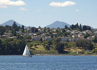
Ladysmith, originally Oyster Harbour, is a town located on the 49th parallel north on the east coast of Vancouver Island, British Columbia, Canada. The local economy is based on forestry, tourism, and agriculture. A hillside location adjacent to a sheltered harbour forms the natural geography of the community.

<span class="mw-page-title-main">Capital Regional District</span> Regional district in British Columbia, Canada

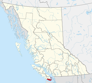
The Capital Regional District (CRD) is a local government administrative district encompassing the southern tip of Vancouver Island and the southern Gulf Islands in the Canadian province of British Columbia. The CRD is one of several regional districts in British Columbia and had an official population of 415,451 as of the Canada 2021 Census.

<span class="mw-page-title-main">Sooke</span> District municipality in British Columbia, Canada

Sooke is a district municipality on the southern tip of Vancouver Island, Canada, 38 kilometres (24 mi) by road from Victoria, the capital of British Columbia. Sooke, the westernmost of Greater Victoria's Western Communities, is to the north and west of the Sooke Basin. It is a regional centre for residents in neighbouring communities, including Otter Point, Shirley and Jordan River.

<span class="mw-page-title-main">Victoria (British Columbia federal electoral district)</span> Federal electoral district in British Columbia, Canada

Victoria is a federal electoral district in British Columbia, Canada, that has been represented in the House of Commons of Canada from 1872 to 1904 and since 1925.

<span class="mw-page-title-main">View Royal</span> Town in British Columbia, Canada

View Royal is a town in Greater Victoria and a member municipality of the Capital Regional District of British Columbia, Canada. View Royal has a population of 11,575 residents. With over 700 hectares of parkland, View Royal includes Thetis, McKenzie, Pike, and Prior Lakes and portions of Esquimalt Harbour and Portage Inlet.

<span class="mw-page-title-main">Oak Bay, British Columbia</span> District municipality in British Columbia, Canada

Oak Bay is a municipality incorporated in 1906 that is located on the southern tip of Vancouver Island, in the Canadian province of British Columbia. It is one of thirteen member municipalities of the Capital Regional District, and is bordered to the west by the city of Victoria and to the north by the district of Saanich. It is an eastern residential suburb of Victoria.

<span class="mw-page-title-main">Duncan, British Columbia</span> City in British Columbia, Canada

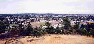
Duncan is a city on southern Vancouver Island in British Columbia, Canada. It is the smallest city by area in Canada. It was incorporated in 1912.

<span class="mw-page-title-main">North Cowichan</span> District municipality in British Columbia, Canada

North Cowichan is a district municipality established in 1873 on Vancouver Island, in British Columbia, Canada. The municipality is part of the Cowichan Valley Regional District. North Cowichan is noted for a landscape including forests, beaches, rivers, and lakes. The municipality encompasses the communities of Chemainus; Westholme; Crofton; Maple Bay; and "the South End". The latter is an informal name for a built-up area which is essentially a suburb of the City of Duncan, a separate municipality.

<span class="mw-page-title-main">Central Saanich</span> District municipality in British Columbia, Canada

Central Saanich is a district municipality in Greater Victoria, British Columbia, Canada, and a member municipality of the Capital Regional District. It is located on the Saanich Peninsula, in the far south-east of Vancouver Island. It is the traditional territory of the W̱SÁNEĆ people. The district began as a farming community, and many hobby farms, along working farms and vineyards, still exist. In recent decades, the area has seen increasing residential, commercial, and industrial development, especially around the neighbourhoods of Brentwood Bay and Saanichton, which are occasionally referred to as separate communities.

<span class="mw-page-title-main">Cowichan Valley Regional District</span> Regional district in British Columbia, Canada

The Cowichan Valley Regional District is a regional district in the Canadian province of British Columbia is on the southern part of Vancouver Island, bordered by the Nanaimo and Alberni-Clayoquot Regional Districts to the north and northwest, and by the Capital Regional District to the south and east. As of the 2021 Census, the Regional District had a population of 89,013. The regional district offices are in Duncan.

<span class="mw-page-title-main">Colwood, British Columbia</span> City in British Columbia, Canada

Colwood is a city located on Vancouver Island to the southwest of Victoria, capital of British Columbia, Canada. Colwood was incorporated in 1985 and has a population of approximately 19,000 people. Colwood lies within the boundaries of the Greater Victoria area or Capital Regional District, in a region called the Western Communities, or the West Shore. It is one of the 13 component municipalities of Greater Victoria.

<span class="mw-page-title-main">Vanderhoof, British Columbia</span> District municipality in British Columbia, Canada

Vanderhoof is a district municipality near the geographical centre of British Columbia, Canada. Covering 2.92 square kilometers, it has a population of about 4,500 within town limits, and offers services to nearly 10,000 people in nearby rural communities. Its main industries are forestry, agriculture, and related businesses. Tourism is also growing, and mining operations are being developed in the area. It has many elementary schools, and one major secondary school, Nechako Valley Secondary School (NVSS), comprising School District 91 Nechako Lakes. The College of New Caledonia has a regional campus there.

<span class="mw-page-title-main">Lake Country</span> District municipality in British Columbia, Canada

Lake Country is a district municipality with a population of approximately 15,000 in the Okanagan Valley region of British Columbia, Canada. It is a part of the Central Okanagan Regional District, and of the Kelowna metropolitan area. The city of Kelowna lies to the south, while the city of Vernon lies to the north. As its name suggests, there are a number of lakes in the vicinity of Lake Country, and outside the municipal boundaries in the hills to the east. Okanagan Lake defines the western boundary of the municipality, while the entirety of Wood Lake and the southernmost portion of Kalamalka Lake are encompassed by it.

<span class="mw-page-title-main">Port Hardy</span> District municipality in British Columbia, Canada

Port Hardy is a district municipality in British Columbia, Canada located on the north-east end of Vancouver Island. Port Hardy has a population of 3,902 as of the 2021 census.

<span class="mw-page-title-main">Northern Rockies Regional Municipality</span> Regional district in British Columbia, Canada

The Northern Rockies Regional Municipality (NRRM), formerly the Northern Rockies Regional District (NRRD), and before that the Fort Nelson–Liard Regional District, is a municipality in northeastern British Columbia, Canada. Although portrayed as a regional municipality in its official name, and existing on the same administrative level as a regional district, it is actually classified as a district municipality. The NRRM's offices are located in Fort Nelson, formerly an incorporated town that amalgamated with the NRRD on February 6, 2009, to form the NRRM. With the Peace River Regional District as the southern part, it was the northern part of the Peace River-Liard Regional District, which was split into two on October 31, 1987.

The District of North Saanich is located on the Saanich Peninsula of British Columbia, approximately 25 km (16 mi) north of Victoria on southern Vancouver Island. It is one of the 13 Greater Victoria municipalities. The district is surrounded on three sides by 20 km (12 mi) of ocean shoreline, and consists of rural/residential areas and a large agricultural base. It is home to the Victoria International Airport and the Swartz Bay Ferry Terminal.

Lake Cowichan is a town located on the east end of Cowichan Lake and, by highway, is 27 kilometres (17 mi) west of Duncan, British Columbia. The town of Lake Cowichan was incorporated in 1944. The Cowichan River flows through the middle of the town. Cowichan River is designated as a Heritage River.

<span class="mw-page-title-main">Esquimalt—Saanich—Sooke</span> Federal electoral district in British Columbia, Canada

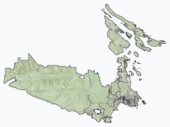
Esquimalt—Saanich—Sooke is a federal electoral district in Greater Victoria, on the southern tip of Vancouver Island in British Columbia, Canada.

References

  1. "British Columbia Regional Districts, Municipalities, Corporate Name, Date of Incorporation and Postal Address" (XLS). British Columbia Ministry of Communities, Sport and Cultural Development. Retrieved November 2, 2014.
  2. Mayor & Council
  3. 1 2 "Sidney, Town [Census subdivision], British Columbia and Capital, Regional district [Census division], British Columbia". Statistics Canada. January 23, 2017. Retrieved February 8, 2017.
  4. Akrigg, G.P.V.; Akrigg, Helen B. (1986), British Columbia Place Names (3rd, 1997 ed.), Vancouver: UBC Press, ISBN   0-7748-0636-2
  5. "Population and dwelling counts: Canada, provinces and territories, and census subdivisions (municipalities), British Columbia". Statistics Canada. February 9, 2022. Retrieved February 20, 2022.
  6. 1 2 "Demographics".
  7. 1 2 Government of Canada, Statistics Canada (October 26, 2022). "Census Profile, 2021 Census of Population". www12.statcan.gc.ca. Retrieved November 9, 2022.
  8. Government of Canada, Statistics Canada (October 27, 2021). "Census Profile, 2016 Census". www12.statcan.gc.ca. Retrieved March 7, 2023.
  9. Government of Canada, Statistics Canada (November 27, 2015). "NHS Profile". www12.statcan.gc.ca. Retrieved March 7, 2023.
  10. Government of Canada, Statistics Canada (August 20, 2019). "2006 Community Profiles". www12.statcan.gc.ca. Retrieved March 7, 2023.
  11. Government of Canada, Statistics Canada (July 2, 2019). "2001 Community Profiles". www12.statcan.gc.ca. Retrieved March 7, 2023.
  12. "• Victoria, BC: house prices by suburb 2020 | Statista".
  13. "Slegg's Annual Event on Canada Day, Build a Boat Contest Sidney BC".
  14. "Victoria INT'L A, British Columbia". Canadian Climate Normals 1981–2010. Environment Canada. October 31, 2011. Retrieved May 8, 2014.
  15. "Climate data for station VICTORIA INT'L A". Environment Canada. Archived from the original on July 13, 2020. Retrieved July 15, 2015.