Royal Roads University is a public university with its main campus in Colwood, British Columbia. It is located at Hatley Park National Historic Site on Vancouver Island. Following the decommissioning of Royal Roads Military College in 1995, the government of British Columbia created Royal Roads University as a public university with an applied and professional degree-granting focus. The university considers alumni of RRMC to be part of its broader alumni community.
Royal Roads Military College (RRMC) was a Canadian military college from 1940 to 1995, located in Hatley Park, Colwood, British Columbia, near Victoria, British Columbia, Canada.

Fernwood is a neighbourhood near downtown Victoria, British Columbia, Canada, bounded by the neighbourhoods of North/South Jubilee, North Park, Fairfield, Rockland, Hillside-Quadra, Oaklands and Harris Green.

Uplands, Victoria is a 188.17-hectare (465.0-acre) neighbourhood located in the north east part of the District of Oak Bay, a suburb adjacent to Victoria, British Columbia, Canada, and situated between the neighbourhoods of Cadboro Bay and North Oak Bay. Uplands is a prominent example of a garden suburb designed in the early part of the 20th century.

The Musqueam Indian Band is a First Nations band government in the Canadian province of British Columbia. It is the only First Nations band whose reserve community lies within the boundaries of the City of Vancouver.
Otter Point is a rural forestry district between other rural district of Shirley and town of Sooke.

Hatley Park National Historic Site is located in Colwood, British Columbia, in Greater Victoria. It is the site of Hatley Castle, a Classified Federal Heritage Building. Since 1995, the mansion and estate have been used for the public Royal Roads University. From the 1940s to 1995, it was used for the Royal Roads Military College, a naval training facility.
Royal Roads is a roadstead or anchorage located in Strait of Juan de Fuca near the entrance to Esquimalt Harbour in Greater Victoria, British Columbia, Canada.

South Cambie is a neighbourhood in the city of Vancouver, British Columbia, Canada, that is generally considered one of the smallest neighbourhoods in the city, both in size and in population. It is wedged between one of the city's largest parks and the upscale neighbourhood of Shaughnessy, and is known for a large cluster of medical facilities.

Cadboro Bay is a bay near the southern tip of Vancouver Island and its adjacent neighbourhood in the municipalities of Saanich and Oak Bay in Greater Victoria, British Columbia, Canada.
Fairfield is a neighbourhood of Victoria, British Columbia. It is bounded by the James Bay, Downtown, Harris Green, Fernwood, Rockland, and Gonzales neighbourhoods, and meets the Strait of Juan de Fuca to the south.

Downtown Victoria is a neighbourhood of Victoria, British Columbia, Canada that serves as the city centre and the central business district for the City of Victoria, and the Greater Victoria regions.

Victoria Harbour is a harbour, seaport, and seaplane airport in the Canadian city of Victoria, British Columbia. It serves as a cruise ship and ferry destination for tourists and visitors to the city and Vancouver Island. It is both a port of entry and an airport of entry for general aviation. Historically it was a shipbuilding and commercial fishing centre. While the Inner Harbour is fully within the City of Victoria, separating the city's downtown on its east side from the Victoria West neighbourhood, the Upper Harbour serves as the boundary between the City of Victoria and the district municipality of Esquimalt. The inner reaches are also bordered by the district of Saanich and the town of View Royal. Victoria is a federal "public harbour" as defined by Transport Canada. Several port facilities in the harbour are overseen and developed by the Greater Victoria Harbour Authority, however the harbour master's position is with Transport Canada.

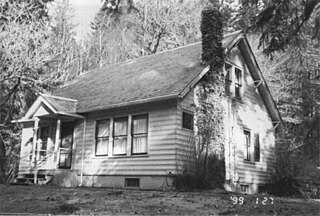
Emery Farmstead, also known as Chancellor-Emery Farmstead, is an historic farm located at the junction of Emery Road and Emery Lane, about 8.5 miles (13.7 km) southeast of Port Angeles, Washington. The farm is composed of five well preserved historic buildings on a 5 acres (2.0 ha) area. The log cabin is the newest building in the farmstead and was built in 1889. Shortly after its construction, and before 1900, the two-story log house was built nearby. The granary and root cellar are two log structures located shortly east of the buildings. A log shed is the original living quarters, built in 1885.

Rosemary Inn is a historic resort located at Barnes Point, on south shore of Lake Crescent, about 17.2 miles (27.7 km) southwest of Port Angeles, in Olympic National Park. The Rosemary Inn historic district comprises a 4.5 acres (1.8 ha) area and encompasses several historical structures built between 1914 and the mid-1930s.
South Oak Bay is a neighbourhood located in the Municipality of Oak Bay, British Columbia, to the south of Oak Bay Avenue and lying east of the boundary between Oak Bay and Victoria, British Columbia.

Victoria West, commonly called Vic West, is an historic neighbourhood of the city of Victoria, British Columbia, Canada, located just west of downtown across Victoria Harbour, bordering on the Township of Esquimalt.
The Elwha Ranger Station is a historic district in Olympic National Park, originally built in the 1930s for the U.S. Forest Service. The complex of fourteen buildings is divided in two by Olympic Hotsprings Road. To the east lie the ranger station and three residences, with nine maintenance buildings on the west side of the road. The complex was turned over to the National Park Service in 1940 when the land was added to Olympic National Park from Olympic National Forest. Construction is typical of USFS practice, and reflects the Forest Service's preference of the time for bungalow and American Craftsman style architecture.
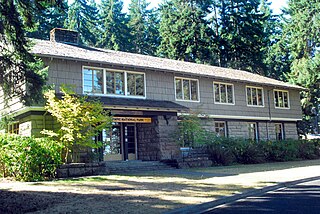
The Olympic National Park Headquarters Historic District overlooks Port Angeles, Washington from Peabody Heights, consisting of 6 contributing buildings built in 1940–44, 8 contributing structures and 17 non-contributing properties that act as the administrative headquarters for Olympic National Park. The contributing structures were built using locally obtained native materials in a late interpretation of the National Park Service Rustic style. Native landscaping enhances the site. Much of the work was carried out by Public Works Administration and Civilian Conservation Corps workers.
