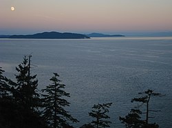
The San Juan Islands is an archipelago in the Pacific Northwest of the United States between the U.S. state of Washington and Vancouver Island, British Columbia, Canada. The San Juan Islands are part of Washington state, and form the core of San Juan County.

The Strait of Juan de Fuca is a body of water about 96 miles long that is the Salish Sea's main outlet to the Pacific Ocean. The international boundary between Canada and the United States runs down the centre of the Strait.
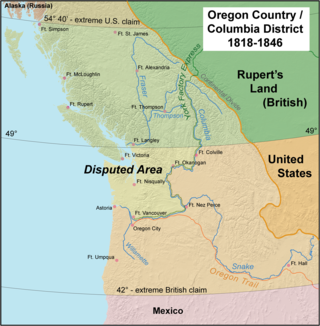
The Oregon Treaty is a treaty between the United Kingdom and the United States that was signed on June 15, 1846, in Washington, D.C. The treaty brought an end to the Oregon boundary dispute by settling competing American and British claims to the Oregon Country; the area had been jointly occupied by both Britain and the U.S. since the Treaty of 1818.

The Pig War was a confrontation in 1859 between the United States and the United Kingdom over the British–U.S. border in the San Juan Islands, between Vancouver Island and the Washington Territory. The Pig War, so called because it was triggered by the shooting of a pig, is also called the Pig Episode, the Pig and Potato War, the San Juan Boundary Dispute, and the Northwestern Boundary Dispute. Despite being referred to as a "war", there were no human casualties on either side.

Gulf Islands National Park Reserve is a national park located on and around the Gulf Islands in British Columbia, Canada. In the National Parks System Plan, this park provides representation of the Strait of Georgia Lowlands natural region, the only place in Canada with a Mediterranean climate of dry, sunny summers and mild, wet winters, the result of a rain shadow effect from surrounding mountains between the region and the ocean. It has similar dominant vegetation as the Pacific Northwest, such as coastal Douglas-fir, western red cedar, shore pine, Pacific dogwood, bigleaf maple, and red alder, but also contains the northern extent of some of the more drought tolerant trees such as Garry oak and Arbutus. The park was created in 2003 as the fortieth national park. It covers 36 square kilometres (14 sq mi) of area on 16 islands and more than 30 islets, reefs and surrounding waters, making it the sixth smallest national park in Canada.

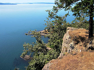
The Strait of Georgia or the Georgia Strait is an arm of the Salish Sea between Vancouver Island and the extreme southwestern mainland coast of British Columbia, Canada, and the extreme northwestern mainland coast of Washington, United States. It is approximately 240 kilometres (150 mi) long and varies in width from 20 to 58 kilometres. Along with the Strait of Juan de Fuca and Puget Sound, it is a constituent part of the Salish Sea.

The Gulf Islands is a group of islands in the Salish Sea between Vancouver Island and the mainland coast of British Columbia.
The Capital Regional District (CRD) is a local government administrative district encompassing the southern tip of Vancouver Island and the southern Gulf Islands in the Canadian province of British Columbia. The CRD is one of several regional districts in British Columbia and had an official population of 415,451 as of the Canada 2021 Census.

San Juan Island National Historical Park, also known as American and English Camps, San Juan Island, is a U.S. National Historical Park owned and operated by the National Park Service on San Juan Island in the state of Washington. The park is made up of the sites of the British and U.S. Army camps during the Pig War, a boundary dispute over the ownership of the island. The camp sites were designated a National Historic Landmark in 1961, and listed on the National Register of Historic Places in 1966. The park was created by an act of Congress in 1966 and expanded slightly in 2013.
Saanich Peninsula is located north of Victoria, British Columbia, Canada. It is bounded by Saanich Inlet on the west, Satellite Channel on the north, the small Colburne Passage on the northeast, and Haro Strait on the east. The exact southern boundary of what is referred to as the "Saanich Peninsula" is somewhat fluid in local parlance.

Rosario Strait is a strait in northern Washington state, separating San Juan County and Skagit and Whatcom Counties. It extends from the Strait of Juan de Fuca about 23 kilometres (14 mi) north to the Strait of Georgia. The USGS defines its southern boundary as a line extending from Point Colville on Lopez Island to Rosario Head on Fidalgo Island, and its northern boundary as a line from Point Migley on Lummi Island to the east tip of Puffin Island and then to Point Thompson on Orcas Island. Rosario Strait runs north-south between Lopez, Decatur, Blakely, and Orcas Islands on the west, and Fidalgo, Cypress, Sinclair, and Lummi Islands on the east.

During the Age of Discovery, the Spanish Empire undertook several expeditions to the Pacific Northwest of North America. Spanish claims to the region date to the papal bull of 1493, and the Treaty of Tordesillas signed in 1494. In 1513, this claim was reinforced by Spanish explorer Vasco Núñez de Balboa, the first European to sight the Pacific Ocean, when he claimed all lands adjoining this ocean for the Spanish Crown. Spain only started to colonize the claimed territory north of present-day Mexico in the 18th century, when it settled the northern coast of Las Californias.

Milbanke Sound is a sound on the coast of the Canadian province of British Columbia.
Francisco de Eliza y Reventa was a Spanish naval officer, navigator, and explorer. He is remembered mainly for his work in the Pacific Northwest. He was the commandant of the Spanish post in Nootka Sound on Vancouver Island, and led or dispatched several exploration voyages in the region, including the Strait of Juan de Fuca and the Strait of Georgia.

José María Narváez was a Spanish naval officer, explorer, and navigator notable for his work in the Gulf Islands and Lower Mainland of present-day British Columbia. In 1791, as commander of the schooner Santa Saturnina, he led the first European exploration of the Strait of Georgia, including a landing on present-day British Columbia's Sunshine Coast. He also entered Burrard Inlet, the site of present-day Vancouver, British Columbia.
Juan Carrasco was a Spanish naval officer, explorer, and navigator. He is remembered mainly for his work in the Pacific Northwest during the late 18th century. He was second in command of the 1791 voyage of José María Narváez, the first European exploration of the Strait of Georgia.
Boundary Pass is a strait that runs for about 23 kilometres (12 nmi) along the boundary between the U.S. state of Washington and the Canadian province of British Columbia. It connects Haro Strait to the south with the Strait of Georgia to the north.
Princess Royal was a British merchant ship that sailed on fur trading ventures in the late 1780s, and was captured at Nootka Sound by Esteban José Martínez of Spain during the Nootka Crisis of 1789. Called Princesa Real while under the Spanish Navy, the vessel was one of the important issues of negotiation during the first Nootka Convention and the difficulties in carrying out the agreements. The vessel also played an important role in both British and Spanish exploration of the Pacific Northwest and the Hawaiian Islands. In 1790, while under Spanish control, Princesa Real carried out the first detailed examination of the Strait of Juan de Fuca by non-indigenous peoples, finding, among other places, the San Juan Islands, Haro Strait, Esquimalt Harbour near present-day Victoria, British Columbia, and Admiralty Inlet.

Carmanah Point Light Station is a lighthouse on the southwest coast of Vancouver Island at the entrance from the Pacific Ocean to the Strait of Juan de Fuca.
North West America was a British merchant ship that sailed on maritime fur trading ventures in the late 1780s. It was the first non-indigenous vessel built in the Pacific Northwest. In 1789 it was captured at Nootka Sound by Esteban José Martínez of Spain during the Nootka Crisis, after which it became part of the Spanish Navy and was renamed Santa Gertrudis la Magna and later Santa Saturnina.