Toba Inlet is one of the lesser, but still principal, inlets of the British Columbia Coast. It is fourth in the series north from the 49th parallel which begins with Burrard Inlet, which is the harbour for the city of Vancouver. Between it and Jervis Inlet to its east, however, there is a freshwater fjord, Powell Lake, which has been augmented by a small hydro project to supply power to the large pulp mill at Powell River, the principal town of the Malaspina Peninsula of the upper Sunshine Coast. Klahoose 1 Reserve, of the Klahoose First Nation is at the mouth of Toba River at the Head of Toba Inlet. Toba Inlet and the Toba Valley is home to many grizzly bears.
Loughborough Inlet is one of the lesser principal inlets of the British Columbia Coast. It penetrates the Coast Mountains on the north side of the Discovery Islands archipelago, running about 35 km (22 mi) from its head at the mouth of the Stafford River to Chancellor Channel and Cordero Channel, which are on the north side of West Thurlow Island. A further 14 km (8.7 mi) west along Chancellor Channel is Johnstone Strait.

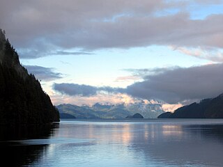
Desolation Sound is a deep water sound at the northern end of the Salish Sea and of the Sunshine Coast in British Columbia, Canada.

Dionisio Alcalá Galiano was a Spanish naval officer, cartographer, and explorer. He mapped various coastlines in Europe and the Americas with unprecedented accuracy using new technology such as chronometers. He commanded an expedition that explored and mapped the Strait of Juan de Fuca and the Strait of Georgia, and made the first European circumnavigation of Vancouver Island. He reached the rank of brigadier and died during the Battle of Trafalgar.
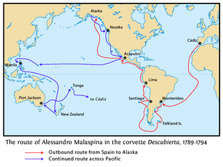
The Malaspina Expedition (1789–1794) was a five-year maritime scientific exploration commanded by Alessandro Malaspina and José de Bustamante y Guerra. Although the expedition receives its name from Malaspina, he always insisted on giving Bustamante an equal share of command. Bustamante however acknowledged Malaspina as the "head of the expedition" since the beginning.

Cayetano Valdés y Flores Bazán (1767–1835) was a commander of the Spanish Navy, explorer, and captain general who served in the French Revolutionary and Napoleonic Wars, fighting for both sides at different times due to the changing fortunes of Spain in the conflict. He took part in a number of naval battles, including the Great Siege of Gibraltar, the Battle of Cape St Vincent, and the Battle of Trafalgar. He was an explorer, most notable in the Pacific Northwest, where he and Dionisio Alcalá Galiano conducted the first circumnavigation of Vancouver Island, in partial cooperation with George Vancouver. Over his long career he achieved the highest ranks in the Spanish Navy, eventually being named Captain General of Cadiz and Captain General of the Spanish Navy.

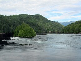
Johnstone Strait is a 110 km (68 mi) channel along the north east coast of Vancouver Island in British Columbia, Canada. Opposite the Vancouver Island coast, running north to south, are Hanson Island, West Cracroft Island, the mainland British Columbia Coast, Hardwicke Island, West Thurlow Island and East Thurlow Island. At that point, the strait meets Discovery Passage which connects to Georgia Strait.

The Vancouver Expedition (1791–1795) was a four-and-a-half-year voyage of exploration and diplomacy, commanded by Captain George Vancouver of the Royal Navy. The British expedition circumnavigated the globe and made contact with five continents. The expedition at various times included between two and four vessels, and up to 153 men, all but 6 of whom returned home safely.

During the Age of Discovery, the Spanish Empire undertook several expeditions to the Pacific Northwest of North America. Spanish claims to the region date to the papal bull of 1493, and the Treaty of Tordesillas signed in 1494. In 1513, this claim was reinforced by Spanish explorer Vasco Núñez de Balboa, the first European to sight the Pacific Ocean, when he claimed all lands adjoining this ocean for the Spanish Crown. Spain only started to colonize the claimed territory north of present-day Mexico in the 18th century, when it settled the northern coast of Las Californias.
Francisco de Eliza y Reventa was a Spanish naval officer, navigator, and explorer. He is remembered mainly for his work in the Pacific Northwest. He was the commandant of the Spanish post in Nootka Sound on Vancouver Island, and led or dispatched several exploration voyages in the region, including the Strait of Juan de Fuca and the Strait of Georgia.
Juan Carrasco was a Spanish naval officer, explorer, and navigator. He is remembered mainly for his work in the Pacific Northwest during the late 18th century. He was second in command of the 1791 voyage of José María Narváez, the first European exploration of the Strait of Georgia.

West Redonda Island is an island in British Columbia, Canada. It is part of the Discovery Islands, an archipelago between Vancouver Island and the mainland, and between the Strait of Georgia and Johnstone Strait.

West Thurlow Island is an island in British Columbia, Canada. It is part of the Discovery Islands, an archipelago between Vancouver Island and the mainland, whose waters connect the Strait of Georgia with Johnstone Strait and Queen Charlotte Strait.

East Thurlow Island is an island in British Columbia, Canada. It is part of the Discovery Islands, an archipelago between Vancouver Island and the mainland, whose waters connect the Strait of Georgia with Johnstone Strait and Queen Charlotte Strait. East Thurlow Island is located north of Vancouver Island, south of the mainland, northwest of Sonora Island, and east of West Thurlow Island. East Thurlow Island is located within Electoral Area C of the Strathcona Regional District.

José Cardero was a Spanish draughtsman and artist. He is most remembered for his work on the expedition of Alejandro Malaspina and the related expedition of Dionisio Alcalá Galiano. During the Galiano voyage Cordero Channel was named in his honor. Other places in British Columbia were later named in his honor as well, including Dibuxante Point, "dibuxante" being Spanish for "draughtsman".

Sutil Channel is a broad strait located in the Discovery Islands of British Columbia, Canada.
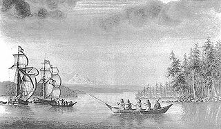
Sutil was a brig-rigged schooner built in 1791 by the Spanish Navy at San Blas, New Spain. It was nearly identical to Mexicana, also built at San Blas in 1791. Both vessels were built for exploring the newly discovered Strait of Georgia, carried out in 1792 under Dionisio Alcalá Galiano, on Sutil, and Cayetano Valdés y Flores, on Mexicana. During this voyage the two Spanish vessels encountered the two British vessels under George Vancouver, HMS Discovery and HMS Chatham, which were also engaged in exploring the Strait of Georgia. The two expeditions cooperated in surveying the complex channels between the Strait of Georgia and Queen Charlotte Strait, in the process proving the insularity of Vancouver Island. After this first voyage Sutil continued to serve the San Blas Naval Department, making various voyages to Alta California and the Pacific Northwest coast.
The Mexicana was a topsail schooner built in 1791 by the Spanish Navy at San Blas, New Spain. It was nearly identical to the Sutil, also built at San Blas later in 1791. Both vessels were built for exploring the newly discovered Strait of Georgia, carried out in 1792 under Dionisio Alcalá Galiano, on the Sutil, and Cayetano Valdés y Flores, on the Mexicana. During this voyage the two Spanish vessels encountered the two British vessels under George Vancouver, HMS Discovery and Chatham, which were also engaged in exploring the Strait of Georgia. The two expeditions cooperated in surveying the complex channels between the Strait of Georgia and Queen Charlotte Strait, in the process proving the insularity of Vancouver Island. After this first voyage the Mexicana continued to serve the San Blas Naval Department, making various voyages to Alta California and the Pacific Northwest coast.

The Descubierta and Atrevida were twin corvettes of the Spanish Navy, custom-designed as identical special exploration and scientific research vessels. They were built at the same time for the Malaspina Expedition. Under the command of Alejandro Malaspina (Descubierta) and José de Bustamante y Guerra (Atrevida) the two vessels sailed from Spain to the Pacific Ocean, conducting a thorough examination of the internal politics of the American Spanish Empire and the Philippines. They explored the coast of Alaska and worked to reinforce Spain's claim to the Pacific Northwest in the aftermath of the Nootka Crisis. After crossing the Pacific Ocean, the colonial government in the Philippines was examined. Exploration and diplomatic reconnaissance followed, with stops in Qing dynasty-era China, New Zealand, Australia, and Tonga.
James Johnstone was a British naval officer and explorer. He is noted for having served as sailing master of the armed tender HMS Chatham and later acting lieutenant during George Vancouver's 1791–1795 expedition to the Pacific Northwest. Johnstone Strait in British Columbia is named after him.