
The K’ómoks or K'omoks, usually known in English as the Comox people, are an indigenous group of Coast Salishan-speaking people in Comox, British Columbia and in Toba Inlet and the Malaspina Peninsula areas of the British Columbia mainland across Georgia Strait. They historically spoke the Komox language (Comox-Sliammon), and were divided in two main dialect and tribal groupings, which are known by academics as Island Comox and Mainland Comox.

Burrard Inlet is a relatively shallow-sided fjord in northwestern Lower Mainland, British Columbia, Canada. Formed during the last Ice Age, it separates the City of Vancouver and the rest of the lowland Burrard Peninsula to the south from the coastal slopes of the North Shore Mountains which span West Vancouver and the City and District of North Vancouver to the north.

Rivers Inlet is a fjord in the Central Coast region of the Canadian province of British Columbia, its entrance off Fitz Hugh Sound, about 125 km (78 mi) southwest of the community of Bella Coola and about 65 km (40 mi) north of the northern tip of Vancouver Island and the western entrance of the Queen Charlotte Strait.

Bute Inlet is one of the principal inlets of the British Columbia Coast. It is 80 km (50 mi) long from the estuaries of the Homathko and Southgate Rivers at the head of the inlet, to the mouth, where it is nearly blocked by Stuart Island, and it averages about 4 km (2.5 mi) in width. Bute Inlet is in a spectacular wilderness setting and is one of the most scenic waterways in the world. In the upper reaches of the inlet mountains rise 2,700 m (9,000 ft) feet above sea level. Bute Inlet is a spectacular wilderness that is visited by very few people. In more recent years tourists are travelling from around the world to view grizzly bears in a natural setting and explore the wilderness of Bute Inlet.

Jervis Inlet is one of the principal inlets of the British Columbia Coast, about 95 km (59 mi) northwest of Vancouver, and the third of such inlets north of the 49th parallel, the first of which is Burrard Inlet, Vancouver's harbour.

Knight Inlet is one of the principal inlets of the British Columbia Coast, and the largest of the major inlets in the southern part of the Coast. It is fifth in sequence of the great saltwater inlets north from the 49th parallel near Vancouver, but it is the first whose outflow points away from the Strait of Georgia, opening into Queen Charlotte Strait at the Kwakwakaʼwakw community of Memkumlis on Village Island.
Kingcome Inlet is one of the lesser principal fjords of the British Columbia Coast, north and east of Broughton Island. It is sixth in sequence of the major saltwater fjords north from the 49th parallel near Vancouver and similar in width, on average 2.5 km (1.6 mi), to longer inlets such as Knight Inlet and Bute Inlet, but it is only 35 km (22 mi) in length from the mouth of the Kingcome River to Sutlej Channel, which ultimately connects around Broughton Island to the main regional waterway of the Queen Charlotte Strait. Kingcome Inlet has a short side inlet, Wakeman Sound, fed by the Wakeman River.
Seymour Inlet is one of the lesser travelled of the principal inlets of the British Columbia Coast. Unlike larger inlets such as Knight or Bute, it is not flanked by mountains but by relatively low, but still rugged, coastal hill-country and forms a maze of complex, narrow waterways and tidal pools and lagoons. It is located within a corresponding maze of peninsulas on the mainland on the northwest side of the Queen Charlotte Strait region.
Dean Channel is the upper end of one of the longest inlets of the British Columbia Coast, 105 km (65.2 mi) from its head at the mouth of the Kimsquit River. The Dean River, one of the main rivers of the Coast Mountains, enters Dean Channel about 9.5 km (5.9 mi) below the head of the inlet, at the community of Kimsquit.
Loughborough Inlet is one of the lesser principal inlets of the British Columbia Coast. It penetrates the Coast Mountains on the north side of the Discovery Islands archipelago, running about 35 km (22 mi) from its head at the mouth of the Stafford River to Chancellor Channel and Cordero Channel, which are on the north side of West Thurlow Island. A further 14 km (8.7 mi) west along Chancellor Channel is Johnstone Strait.

Desolation Sound is a deep water sound at the northern end of the Salish Sea and of the Sunshine Coast in British Columbia, Canada.
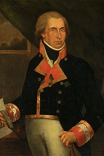
Dionisio Alcalá Galiano was a Spanish naval officer, cartographer, and explorer. He mapped various coastlines in Europe and the Americas with unprecedented accuracy using new technology such as chronometers. He commanded an expedition that explored and mapped the Strait of Juan de Fuca and the Strait of Georgia, and made the first European circumnavigation of Vancouver Island. He reached the rank of brigadier and died during the Battle of Trafalgar.

Indian Arm is a steep-sided glacial fjord adjacent to the city of Vancouver in southwestern British Columbia. Formed during the last Ice Age, it extends due north from Burrard Inlet, between the communities of Belcarra and the District of North Vancouver, then on into mountainous wilderness. Burrard Inlet and the opening of Indian Arm was mapped by Captain George Vancouver and fully explored days later by Dionisio Alcalá Galiano in June 1792.

Cortes Island is an island in the Discovery Islands archipelago on the coast of British Columbia, Canada. The island is 25 km (15.5 mi) long, 13 km (8.1 mi) wide, and 130 km2 (50 sq mi) in area. It has a population of 1,035 permanent residents. Cortes Island lies within Electoral Area B of the Strathcona Regional District, which provides water and sewerage systems, fire protection, land use planning, parks, recreation, and emergency response.

The Vancouver Expedition (1791–1795) was a four-and-a-half-year voyage of exploration and diplomacy, commanded by Captain George Vancouver of the Royal Navy. The British expedition circumnavigated the globe and made contact with five continents. The expedition at various times included between two and four vessels, and up to 153 men, all but six of whom returned home safely.

The ƛoʔos Klahoose are one of the three groups comprising the ʔayʔaǰuθəm Tla'Amin or Mainland Comox. The other two divisions of this once-populous group are the χʷɛmaɬku Homalco and Sliammon. The Klahoose, Homalco and Sliammon are, according to oral tradition, the descendants of the survivors of the Great Flood. The three groups were split by colonialism into different band councils but united historically as the Tla A'min, known as the Mainland Comox, and K’ómoks, the larger grouping of the Comox people, also known as the Island Comox and before the merger with the Laich-kwil-tach culture. Historically both groups are a subgroup of the Coast Salish though the K’ómoks name is from, and their language today, is the Lik'wala dialect of Kwak'wala. The ancestral tongue is the Comox language, though the Sahtloot/Island dialect is extinct.

West Redonda Island is an island in British Columbia, Canada. It is part of the Discovery Islands, an archipelago between Vancouver Island and the mainland, and between the Strait of Georgia and Johnstone Strait.
Cordero Channel is a strait in British Columbia, Canada, located between the mainland and Vancouver Island, among the Discovery Islands north of the Strait of Georgia. Cordero Channel runs north of Sonora Island, East Thurlow Island, and part of West Thurlow Island. Its eastern end connects to the mouth of Bute Inlet and to Calm Channel, at Stuart Island. Its west end is marked by the mouth of Loughborough Inlet, beyond which the channel is called Chancellor Channel, which continues west to Johnstone Strait.
The Malaspina Peninsula is a peninsula in the northern Gulf of Georgia-Sunshine Coast region of British Columbia, Canada. It extends northwest from the town of Powell River, which lies near its isthmus, past the settlement of Lund, to Desolation Sound. This sound spans the opening of Toba Inlet, a fjord lying between Lund and the Discovery Islands to the west and northwest.
Homfray Channel is a deep water channel, reaching depths of 731 meters, located between East Redonda and the mainland coast of British Columbia, Canada.


