The Stʼatʼimc, also known as the Lillooet, St̓át̓imc, or Stl'atl'imx, are an Interior Salish people located in the southern Coast Mountains and Fraser Canyon region of the Interior of the Canadian province of British Columbia.
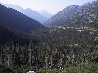
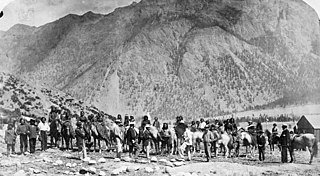
White Pass, also known as the Dead Horse Trail, is a mountain pass through the Boundary Ranges of the Coast Mountains on the border of the U.S. state of Alaska and the province of British Columbia, Canada. It leads from Skagway, Alaska, to the chain of lakes at the headwaters of the Yukon River.

The Chilkoot River is a river in Southeast Alaska, United States, that extends about 20 miles (32 km) from its source and covers a watershed area of 100 square miles (260 km2). The source of the river is in the Takshanuk Mountains to the west and the Freebee glacier and unnamed mountains to the east. From its source, the upper reach of the river extends approximately 16 miles (26 km) to the point where it enters Chilkoot Lake. From the downstream end of the lake, the lower reach of the river flows for about 1.5 miles (2.4 km) until it enters the Chilkoot Inlet, a branch at the northern end of the Lynn Canal.

The Taku River is a river running from British Columbia, Canada, to the northwestern coast of North America, at Juneau, Alaska. The river basin spreads across 27,500 square kilometres (10,600 sq mi). The Taku is a very productive salmon river and its drainage basin is primarily wilderness.

Shuswap Lake is a lake located in the southern interior of British Columbia, Canada that drains via the Little Shuswap River into Little Shuswap Lake. Little Shuswap Lake is the source of the South Thompson River, a branch of the Thompson River, a tributary of the Fraser River. It is at the heart of a region known as the Columbia Shuswap or "the Shuswap", noted for its recreational lakeshore communities including the city of Salmon Arm. The name "Shuswap" is derived from the Shuswap or Secwepemc First Nations people, the most northern of the Interior Salish peoples, whose territory includes the Shuswap. The Shuswap call themselves /ʃǝxwépmǝx/ in their own language, which is called /ʃǝxwepmǝxtʃín/.

The Boundary Ranges, also known in the singular and as the Alaska Boundary Range, are the largest and most northerly subrange of the Coast Mountains. They begin at the Nass River, near the southern end of the Alaska Panhandle in the Canadian province of British Columbia and run to the Kelsall River, near the Chilkoot Pass, beyond which are the Alsek Ranges of the Saint Elias Mountains, and northwards into the Yukon Territory flanking the west side of the Yukon River drainage as far as Champagne Pass, north of which being the Yukon Ranges. To their east are the Skeena Mountains and Stikine Plateau of the Interior Mountains complex that lies northwest of the Interior Plateau; the immediately adjoining subregion of the Stikine Plateau is the Tahltan Highland. To their northeast is the Tagish Highland, which is a subregion of the Yukon Plateau. Both highlands are considered in some descriptions as included in the Coast Mountains. The Alexander Archipelago lies offshore and is entirely within Alaska.
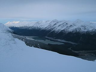
The Chilkoot Lake, in the Tlingit Indians region of Alaska, is also spelt Chilcoot Lake. Its other local names are the Akha Lake and Tschilkut S(ee), meaning "Chilkoot Lake". It is in Haines Borough, Alaska. Chilkoot also means "big fish". The lake has a ‘Recreation Site’ at its southern end near the outlet to the Chilkoot River, which is set amidst the Sitka spruce trees. Chilkoot River flows from the lake for a short length and debouches into the Lutak Channel at the head of the Chilkoot inlet near Haines. Chilkoot village, a settlement of Chilkoot Indians existed at the outlet of the lake, which was called Tschilkut or Tananel or Chilcoot; the lake is named after this village. This village is now a camping area developed by the State Parks and Outdoor Recreation Division of the Alaska Department of Natural Resources. The lake is a popular location for Kayaking.
The Sheslay River is a tributary of the Inklin River in northwest part of the province of British Columbia, Canada. It joins the Nahlin River to form the Inklin River, one of the main tributaries of the Taku River. The lower Sheslay River marks the boundary between the Taku Plateau and the Nahlin Plateau. Its mouth at the Nahlin River marks the junction of the Taku, Nahlin, and Kawdy Plateaus. All three of these are part of the larger Stikine Plateau region.
The Hackett River is a tributary of the Sheslay River in northwest part of the province of British Columbia, Canada. It flows generally northwest about 33 km (21 mi), through two lakes, a wetland, and a gorge, to join the Sheslay River, which in turn is a tributary of the Inklin River, the main southeast fork of the Taku River.
Kakuchuya Creek, historically called the Kakuchuya River, is a tributary of the Dudidontu River and part of the Taku River watershed in northwest part of the province of British Columbia, Canada.
Taku River/T'aḵú Téiú' Conservancy is a conservancy located in the Stikine Region of British Columbia, Canada. It was established on June 22, 2012, as a result of the Wóoshtin Wudidaa Atlin Taku Land Use Plan and Taku River Tlingit First Nation Strategic Engagement Agreement. The conservancy protects a large region of pristine wilderness along the Taku River from its confluence with the Nakina and Inklin Rivers to the Canada–United States border] with Alaska.
The Dudidontu River is a tributary of the Nahlin River in northwest part of the province of British Columbia, Canada. It joins the Nahlin River, which forms the Inklin River, one of the main tributaries of the Taku River. The Dudidontu River's watershed covers 964 km2 (372 sq mi), and its mean annual discharge is 15.4 m3/s (540 cu ft/s). Almost half of the Dudidontu's flow comes from its main tributary, Kakuchuya Creek, and Kakuchuya Creek's main tributary, Matsatu Creek. The mouth of the Dudidontu River is located about 150 km (93 mi) northeast of Juneau, Alaska and about 110 km (68 mi) northwest of Telegraph Creek, British Columbia.
Vernon—Lake Country—Monashee is a future federal electoral district in British Columbia, Canada.
