Related Research Articles

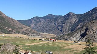
Lillooet is a district municipality in the Squamish-Lillooet region of southwestern British Columbia. The town is on the west shore of the Fraser River immediately north of the Seton River mouth. On BC Highway 99, the locality is by road about 100 kilometres (62 mi) northeast of Pemberton, 64 kilometres (40 mi) northwest of Lytton, and 172 kilometres (107 mi) west of Kamloops.

The Fraser Canyon is a major landform of the Fraser River where it descends rapidly through narrow rock gorges in the Coast Mountains en route from the Interior Plateau of British Columbia to the Fraser Valley. Colloquially, the term "Fraser Canyon" is often used to include the Thompson Canyon from Lytton to Ashcroft, since they form the same highway route which most people are familiar with, although it is actually reckoned to begin above Williams Lake at Soda Creek Canyon near the town of the same name.

The Bridge River is an approximately 120 kilometres (75 mi) long river in southern British Columbia. It flows south-east from the Coast Mountains. Until 1961, it was a major tributary of the Fraser River, entering that stream about six miles upstream from the town of Lillooet; its flow, however, was near-completely diverted into Seton Lake with the completion of the Bridge River Power Project, with the water now entering the Fraser just south of Lillooet as a result.

The Camelsfoot Range is a sub-range of the Chilcotin Ranges subdivision of the Pacific Ranges of the Coast Mountains in British Columbia. The Fraser River forms its eastern boundary. The range is approximately 90 km at its maximum length and less than 30 km wide at its widest.

A quiggly hole, also known as a pit-house or simply as a quiggly or kekuli, is the remains of an earth lodge built by the First Nations people of the Interior of British Columbia and the Columbia Plateau in the United States. The word quiggly comes from kick willy or keekwulee, the Chinook Jargon word for "beneath" or "under".
The Birkenhead River, formerly known as the Portage River, the Pole River and the Mosquito River, is a major tributary of the Lillooet River, which via Harrison Lake and the Harrison River is one of the major tributaries of the lower Fraser River. It is just over 50 km long from its upper reaches in the unnamed ranges south of Bralorne, British Columbia ; their western area towards the named Bendor Range east of Bralorne is sometimes called the Cadwallader Ranges.
Tyaughton Creek, formerly gazetted as the Tyaughton River, also historically known as Tyoax Creek, is a 50 kilometre tributary of British Columbia's Bridge River, flowing generally southeast to enter the main flow of that river about mid-way along the length of Carpenter Lake, a reservoir formed by Terzaghi Dam of the Bridge River Power Project.

Gold Bridge is an unincorporated community in the Bridge River Country of British Columbia, Canada. Although numbering only around 40 inhabitants, Gold Bridge is the service and supply centre for the upper basin of the Bridge River Valley, which includes recreation-residential areas at the Gun Lakes, Tyaughton Lake, Marshall Creek, and Bralorne; and the nearby ghost towns of Brexton and Pioneer Mine.
The Lillooet Country, also referred to as the Lillooet District, is a region spanning from the central Fraser Canyon town of Lillooet west to the valley of the Lillooet River, and including the valleys in between, in the Southern Interior of British Columbia. Like other historical BC regions, it is sometimes referred to simply as The Lillooet or even Lillooet,.
Fountain is an unincorporated rural area and Indian reserve community in the Fraser Canyon region of British Columbia, Canada, located at the ten-mile (16 km) mark from the town of Lillooet on BC Highway 99, which in that area is also on the route of the Old Cariboo Road and is located at the junction of that route with the old gold rush-era trail via Fountain Valley and the Fountain Lakes.
Cadwallader Creek is an important tributary of the Hurley River in the Bridge River Country of the British Columbia Interior, Canada, most notable for its role as the home of the Bralorne and Pioneer Mines and associated gold claims and workings. Less than twenty miles in length, the creek is joined by Noel Creek within the area of the town of Bralorne, and just below Bralorne joins the Hurley River just above Hurley Falls and that river's ten-mile canyon prior to its own confluence with the Bridge River near the town Gold Bridge. Standard Creek, a short tributary of Cadwallader Creek near its upper end, connects via McGillvray Pass to the creek of the same name and, on Anderson Lake far below, the resort townlet of McGillivray Falls. One-time plans to build a cog railway to the mines from the Pacific Great Eastern at McGillivary Falls were never fulfilled.
Pemberton Pass, 505 m (1,657 ft), also formerly known as Mosquito Pass, is the lowest point on the divide between the Lillooet and Fraser River drainages, located at Birken, British Columbia, Canada, in the principal valley connecting and between Pemberton and Lillooet. The pass is a steep-sided but flat-bottomed valley adjacent to Mount Birkenhead and forming a divide between Poole Creek, a tributary of the Birkenhead River, which joins the Lillooet at Lillooet Lake, and the Gates River which flows northeast from Gates Lake, at the summit of the pass, which flows to the Fraser via Anderson and Seton Lakes and the Seton River.
Railroad Pass, 1385 m (4544 ft), usually known locally as Railway Pass, is a mountain pass in the Pacific Ranges of the Coast Mountains in southwestern British Columbia, Canada. Traversed by a seasonal dirt road known as the Hurley Main and sometimes also referred to therefore as Hurley Pass, the pass connects the Pemberton Meadows area of the upper valley of the Lillooet River, via Railroad Creek, to the uppermost reaches of the Hurley River, the main south fork of the Bridge River which the Hurley joins at the settlement of Gold Bridge.
Rutherford Creek is a tributary of the Green River, British Columbia, Canada, entering that river a few miles above Nairn Falls Provincial Park, near the village of Pemberton. The creek's headwaters are on the eastern side of the Pemberton Icefield, from where it flows southeast for the first half of its course, then generally east for the remainder. It is approximately 24 km (15 mi) in length. The mouth is at 50° 16' 3" N, 122° 57' 41" W.

Cayoosh Creek is a northeast-flowing tributary of the Seton River in the Canadian province of British Columbia. The name Cayoosh Creek remains on the bridge-sign crossing the stream on BC Highway 99 and continues in use locally to refer to the final reaches of the Seton River, formerly Seton Creek, which prior to the renaming ending at the confluence with Cayoosh Creek. The creek is the namesake of Cayoosh Creek Indian Reserve No. 1, one of the main Indian reserves of the Cayoose Creek Indian Band, which lies adjacent to what was renamed the Seton River without local consultation.
Mission Ridge, also known as Mission Mountain, is a ridge in the Bridge River-Lillooet Country of the South-Central Interior of British Columbia, Canada, extending westward from the town of Lillooet along the north side of Seton Lake to Mission Pass, which is immediately above and to the north of the lakeside community of Shalalth. The road over the pass is also known as Mission Mountain, which is short for "Mission Mountain Road". Mission Creek lies on the north side of the pass, and is a tributary of the Bridge River, the lower reaches of which lie on the north side of the ridge, and which was the only road access into the upper Bridge River Country before the construction of a road through the Bridge River Canyon in the mid-1950s opened that region up to road access from the lower Bridge River valley and the town of Lillooet via the community of Moha. Most, or virtually all, of the ridge, is Indian Reserves, notably Slosh 1, under the administration of the Seton Lake Indian Band, and Bridge River 1, which is under the administration of the Bridge River Indian Band. Parts of the ridge's eastern end are in reserves controlled by the Lillooet Indian Band, including its final spires above Lillooet, which were dubbed St. Mary's Mount by the Reverend Lundin Brown in the 1860s, though that name never stuck and is ungazetted.
The Bridge River Rapids, also known as the Six Mile Rapids, the Lower Fountain, the Bridge River Fishing Grounds, and in the St'at'imcets language as Sat' or Setl, is a set of rapids on the Fraser River, located in the central Fraser Canyon at the mouth of the Bridge River six miles north of the confluence of Cayoosh Creek with the Fraser and on the northern outskirts of the District of Lillooet, British Columbia, Canada.
Brexton, formerly known as Fish Lake, is a ghost town located in the Bridge River Country region of British Columbia. Although the provincial Gazetteer still lists the "settlement" of Brexton, which was situated between the southeast end of Gun Lake and Gold Bridge, and three and a half miles north of Bralorne, this once busy town has mostly vanished though a few buildings remain. The old town site now sits mainly on private property.
Glen Fraser is a locality in the central Fraser Canyon of the Central Interior of British Columbia, Canada, located c. 18 miles north of the town of Lillooet and between the communities of Fountain (S) and Pavilion. It is a ranching area formed of benchlands on the west side of the Fraser and is the location of the Keatley Creek Archaeological Site, one of Canada's most important ongoing investigations. The name was conferred as that of a railway stop on the Pacific Great Eastern Railway, now Canadian National.
Haylmore is a location in the Bridge River Country of the southwestern Interior of British Columbia, Canada, located near the town of Gold Bridge just below the confluence of the Bridge River and its south fork, the Hurley River.