Contents
This is a list of rivers of Yukon.
This is a list of rivers of Yukon.

The Yukon River is a major watercourse of northwestern North America. From its source in British Columbia, it flows through Canada's territory of Yukon. The lower half of the river continues westward through the U.S. state of Alaska. The river is 3,190 kilometres (1,980 mi) long and empties into the Bering Sea at the Yukon–Kuskokwim Delta. The average flow is 6,400–7,000 m3/s (230,000–250,000 cu ft/s). The total drainage area is 854,700 km2 (330,000 sq mi), of which 323,800 km2 (125,000 sq mi) lies in Canada. The total area is more than 25% larger than Texas or Alberta.

Kluane National Park and Reserve are two protected areas in the southwest corner of the territory of Yukon. The National Park Reserve was set aside in 1972 to become a national park, pending settlement of First Nations land claims. It covered an area of 22,013 square kilometres. When agreement was reached with the Champagne and Aishihik First Nations over an eastern portion of the Reserve, that part—about 5,900 square kilometres —became a national park in 1993, and is a unit of the national park system administered co-operatively with Parks Canada. The larger western section remains a Reserve, awaiting a final land claim settlement with the Kluane First Nation. The park borders British Columbia to the south, while the Reserve borders both British Columbia to the south, and the United States (Alaska) to the south and west.

The Liard River of the North American boreal forest flows through Yukon, British Columbia and the Northwest Territories, Canada. Rising in the Saint Cyr Range of the Pelly Mountains in southeastern Yukon, it flows 1,115 km (693 mi) southeast through British Columbia, marking the northern end of the Rocky Mountains and then curving northeast back into Yukon and Northwest Territories, draining into the Mackenzie River at Fort Simpson, Northwest Territories. The river drains approximately 277,100 km2 (107,000 sq mi) of boreal forest and muskeg.

Alsek River is a wilderness river flowing from Yukon into Northern British Columbia and into Alaska. It enters the Gulf of Alaska at Dry Bay.

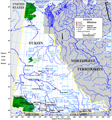
Yukon is in the northwestern corner of Canada and is bordered by Alaska, British Columbia and the Northwest Territories. The sparsely populated territory abounds with natural scenery, snowmelt lakes and perennial white-capped mountains, including many of Canada's highest mountains. The territory's climate is Arctic in territory north of Old Crow, subarctic in the region, between Whitehorse and Old Crow, and humid continental climate south of Whitehorse and in areas close to the British Columbia border. Most of the territory is boreal forest with tundra being the main vegetation zone only in the extreme north and at high elevations.

Tatshenshini-Alsek Park or Tatshenshini-Alsek Provincial Wilderness Park is a provincial park in British Columbia, Canada. The park is 9,580 km2 (3,700 sq mi) in size. It was established in 1993 after an intensive campaign by Canadian and American conservation organizations to halt mining exploration and development in the area, and protect the area for its strong natural heritage and biodiversity values.

Kluane Lake is located in the southwest area of the Yukon. It is the largest lake contained entirely within Yukon at approximately 408 km2 (158 sq mi), and 81 km (50 mi) long.
Yukon Energy Corporation is a Crown corporation that is the primary producer of electricity in the Canadian territory of Yukon. It also distributes electricity to a small number of locations not served by the privately-owned ATCO Electric Yukon. YEC was established in 1987 to take over the Yukon assets of the Northern Canada Power Commission and is currently organised as a subsidiary of the Yukon Development Corporation. The company's headquarters is in Whitehorse, Yukon near the Whitehorse Rapids hydroelectric generating station.
ATCO Electric Yukon, formerly Yukon Electrical Company Limited (YECL), is a private electrical utility based in Whitehorse, Yukon, serving most Yukon communities and Lower Post, British Columbia. The company, founded in 1901, is owned by ATCO of Alberta. Through mergers and acquisitions, Yukon Electrical extended to serve most communities in Yukon.

The Tatshenshini River is a river in the Canadian boreal forest, in the southwestern Yukon and the northwestern corner of British Columbia. It originates in British Columbia, near Haines Highway. It flows north into Yukon, then it turns west and south before it returns into British Columbia, where it flows through the Tatshenshini-Alsek Provincial Wilderness Park. There it joins the Alsek River, which then flows into the Pacific Ocean in Alaska, United States. It is popular for wilderness rafting trips.
Southern Lakes was an electoral district in rural Yukon which returned a member to the Legislative Assembly of the Yukon in Canada. It was one of the eight rural ridings in the Yukon at the time.

Lake Laberge is an electoral district which returns a member to the Legislative Assembly of the Yukon Territory in Canada. It is one of the Yukon's eight rural districts and is named after the eponymous Lake Laberge, which is within the riding.

Kluane is an electoral district which returns a member to the Legislative Assembly of the Canadian territory of Yukon. It is named after Kluane National Park, which is within the riding. It is one of the Yukon's eight rural districts.

The history of the Yukon covers the period from the arrival of Paleo-Indians through the Beringia land bridge approximately 20,000 years ago. In the 18th century, Russian explorers began to trade with the First Nations people along the Alaskan coast, and later established trade networks extending into Yukon. By the 19th century, traders from the Hudson's Bay Company were also active in the region. The region was administered as a part of the North-Western Territory until 1870, when the United Kingdom transferred the territory to Canada and it became the North-West Territories.
Teslin Lake is a large lake spanning the border between British Columbia and Yukon, Canada. It is one of a group of large lakes in the region of far northwestern BC, east of the upper Alaska Panhandle, which are the southern extremity of the basin of the Yukon River, and which are known in Yukon as "the Southern Lakes". The lake is fed and drained primarily by the Teslin River, south and north, but is also fed from the east by the Jennings River and the Swift River, and from the west by the Hayes River.
Nahani is an Athabaskan word used to designate First Nations groups located in British Columbia, the Northwest Territories and Yukon between the upper Liard River and the 64th parallel north latitude. While these native groups do not necessarily have anything in common, the Canadian government used the term "Nahani" until the 1970s to refer to them collectively. The group term applied to several distinct tribes:
Kusawa Lake is a lake in the southern Yukon, Canada. Kusawa means "long narrow lake" in the Tlingit language. The Kusawa Lake is a lake in Canada's Yukon Territory. It is located at an altitude of 671 m (2,201 ft) and is 60 km (37 mi) southwest of Whitehorse near the British Columbia border. It meanders over a length of 75 km (47 mi) with a maximum width of about 2.5 km (1.6 mi) through the mountains in the north of the Boundary Ranges. It is fed by the Primrose River and Kusawa River. The Takhini outflows to the Yukon River from the northern tip of Kusawa Lake. Kusawa Lake has an area of 142 km2 (55 sq mi). The lake has a maximum depth of 140 m (460 ft) and is of glacial origin. It is a common tourist destination and is also popular for fishing.

The Indigenous peoples of Yukon are ethnic groups who, prior to European contact, occupied the former countries now collectively known as Yukon. While most First Nations in the Canadian territory are a part of the wider Dene Nation, there are Tlingit and Métis nations that blend into the wider spectrum of indigeneity across Canada. Traditionally hunter-gatherers, indigenous peoples and their associated nations retain close connections to the land, the rivers and the seasons of their respective countries or homelands. Their histories are recorded and passed down the generations through oral traditions. European contact and invasion brought many changes to the native cultures of Yukon including land loss and non-traditional governance and education. However, indigenous people in Yukon continue to foster their connections with the land in seasonal wage labour such as fishing and trapping. Today, indigenous groups aim to maintain and develop indigenous languages, traditional or culturally-appropriate forms of education, cultures, spiritualities and indigenous rights.