
The Stikine River is a major river in northern British Columbia (BC), Canada and southeastern Alaska in the United States. It drains a large, remote upland area known as the Stikine Country east of the Coast Mountains. Flowing west and south for 610 kilometres (379 mi), it empties into various straits of the Inside Passage near Wrangell, Alaska. About 90 percent of the river's length and 95 percent of its drainage basin are in Canada. Considered one of the last truly wild large rivers in BC, the Stikine flows through a variety of landscapes including boreal forest, steep canyons and wide glacial valleys.

The Skeena River is the second-longest river entirely within British Columbia, Canada. Since ancient times, the Skeena has been an important transportation artery, particularly for the Tsimshian and the Gitxsan—whose names mean "inside the Skeena River" ,and "people of the Skeena River," respectively. The river and its basin sustain a wide variety of fish, wildlife, and vegetation, and communities native to the area depend on the health of the river. The Tsimshian migrated to the Lower Skeena River, and the Gitxsan occupy territory of the Upper Skeena.

The Kechika River is a tributary of the Liard River, about 300 kilometres (190 mi) long, in northern British Columbia, Canada. The Kechika flows generally northwest through the northernmost section of the Rocky Mountain Trench before turning east to join the Liard, a major branch of the Mackenzie River system. The river's 22,700 km2 (8,800 sq mi) drainage basin is characterized by high glaciated peaks, boreal forest, and open tundra. With no settlements, roads or dams along its course, the Kechika is considered "one of British Columbia's finest examples of wilderness and undisturbed wildlife habitat."
Iskut is a small, mostly Indigenous community in the Stikine Country of northwestern British Columbia. It is located on Highway 37, at the north end of Eddontenajon Lake just south of Dease Lake and the crossing of the Stikine River.
Spatsizi Headwaters Provincial Park is a provincial park in the Stikine Region of British Columbia, Canada. It was established on January 25, 2001 to protect the headwaters of the Spatsizi River while providing recreational facilities for visitors.
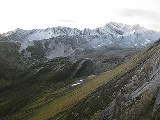
Spatsizi Plateau Wilderness Provincial Park is a provincial park in British Columbia, Canada, protecting most of the Spatsizi Plateau, the southeasternmost subplateau of the Stikine Plateau, and the upper reaches of the basin of the Stikine River.
The Skeena Mountains, also known as the Skeenas, are a subrange of the Interior Mountains of northern British Columbia, Canada, essentially flanking the upper basin of the Skeena River. They lie just inland from the southern end of the Boundary Ranges of the Coast Mountains, and also of the northern end of the Kitimat Ranges. Their southern limit is described by the Bulkley River and the upper northwestern reaches of Babine and Takla Lakes, and on their northeast by the upper reaches of the Omineca River.

The Interior Mountains or Northern Interior Mountains are the semi-official names for an expansive collection of mountain ranges that comprises much of the northern half of the Canadian province of British Columbia and a large area of southern Yukon.
The Grand Canyon of the Stikine is a 72 km (45 mi) stretch of the Stikine River in northern British Columbia, Canada. It has been compared to the Grand Canyon of the Colorado. The canyon is home to a large population of mountain goats and other wildlife. Officially the canyon is described as unnavigable by any watercraft, however there have been numerous successful descents made by expert whitewater paddlers since the first attempt in 1981. Since it was first attempted, the Grand Canyon of the Stikine has maintained a legendary reputation among whitewater experts as the 'Mt. Everest' of big water expedition whitewater boating against which all other navigable rivers are measured.

The Stikine Plateau is a plateau in northern British Columbia, Canada. It lies between the Boundary Ranges of the Coast Mountains on the west and southwest and the Cassiar Mountains along its northeast, and between the Skeena Mountains on its south and southeast and the Jennings and Nakina Rivers on the north.

The Iskut River, located in the northwest part of the province of British Columbia is the largest tributary of the Stikine River, entering it about 11 km (6.8 mi) above its entry into Alaska.
The Spatsizi Plateau is a plateau in the upper basin of the Stikine River in north-central British Columbia, Canada. Most of the plateau, which is a sub-plateau of the Stikine Plateau, is enshrined in either Spatsizi Plateau Wilderness Provincial Park or Spatsizi Headwaters Provincial Park. It is flanked on the south and southwest by the Skeena Mountains, on the southeast by the Omineca Mountains, on the northeast by the Stikine Ranges of the Cassiar Mountains, and on the west by the Klastline Plateau.
Spatsizi Mountain is a mountain in the Spatsizi Plateau, a sub-plateau of the Stikine Plateau in north-central British Columbia, Canada. The name "Spatsizi" derives from the Sekani language and means "red goat", as mountain goats in this region are known to roll on a particular red mountain, resulting in a red colour to their coats.
Mount Gunanoot is a mountain in the Spatsizi Plateau of the North-Central Interior of British Columbia, Canada, located just east of the headwaters of the Spatsizi River. It is named for Simon Gunanoot, a Gitxsan packer, entrepreneur and erstwhile fugitive who was hunted for several years before turning himself in for trial and being acquitted. Gunanoot is responsible for "opening up" most of the country in this region.
The Craig River is a transboundary river tributary of the Iskut River in Southeast Alaska, United States, and the northwest part of the province of British Columbia, Canada. Originating in Alaska, where it is sometimes called the South Fork Craig River, the Craig flows into British Columbia, generally in a northeast then northwest direction for about 50 km (31 mi) to join the Iskut River about 2 km (1.2 mi) east of the confluence of the Iskut and Hoodoo River. Its main tributary is the Jekill River.
The Tuya River is a major tributary of the Stikine River in northwest part of the province of British Columbia, Canada. From its source at High Tuya Lake in Tuya Mountains Provincial Park just south of Ash Mountain, the highest peak of the Tuya Range, the Tuya River flows south about 200 km (120 mi) to meet the Stikine River in the Grand Canyon of the Stikine. The Tuya River's main tributary is the Little Tuya River. The Tuya River divides the Tanzilla Plateau on the east from the Kawdy Plateau, to the northwest, and the Nahlin Plateau, to the southwest. All three are considered sub-plateaus of the Stikine Plateau. The Tuya River's watershed covers 3,575 km2 (1,380 sq mi), and its mean annual discharge is estimated at 36.9 m3/s (1,300 cu ft/s). The mouth of the Tuya River is located about 24 km (15 mi) northeast of Telegraph Creek, British Columbia, about 67 km (42 mi) southwest of Dease Lake, British Columbia, and about 210 km (130 mi) east of Juneau, Alaska. The Tuya River's watershed's land cover is classified as 35.7% shrubland, 31.4% conifer forest, 14.0% mixed forest, 7.2% herbaceous, and small amounts of other cover.
Raspberry Creek is a tributary of Mess Creek, which in turn is a tributary of the Stikine River in northwest part of the province of British Columbia, Canada. It flows generally northwest for at least 12 km (7.5 mi) to join Mess Creek about 6 km (3.7 mi) north of Mess Creek's confluence with Kitsu Creek. Raspberry Creek's watershed covers 129 km2 (50 sq mi) and its mean annual discharge is estimated at 3.472 m3/s (122.6 cu ft/s). The mouth of Raspberry Creek is located about 40 km (25 mi) southeast of Telegraph Creek, about 61 km (38 mi) southwest of Iskut and about 110 km (68 mi) southwest of Dease Lake. Raspberry Creek's watershed's land cover is classified as 35.1% barren, 24.9% shrubland, 20.7% conifer forest, 16.8% herbaceous, and small amounts of other cover.
Beatty Creek is a tributary of the Tahltan River in northwest part of the province of British Columbia, Canada. It flows generally south about 62 km (39 mi) to join the Tahltan River a few kilometres downstream from the Little Tahltan River confluence. The Tahltan River is one of the main tributaries of the Stikine River.
The Little Iskut River is a tributary of the Iskut River in the northwest part of the province of British Columbia, Canada, in Cassiar Land District. From its source at Little Ball Lake in Mount Edziza Provincial Park, the Little Iskut River flows about 45 km (28 mi), generally north to the vicinity of Mowdale Lake, then southeast and south to the Iskut River just below Cascade Falls. The Little Iskut River is part of the Stikine River drainage basin, as the Iskut River is a major tributary of the Stikine.
The Klastline River is a tributary of the Stikine River in northwestern British Columbia, Canada. It flows generally northwest about 70 km (43 mi) to join the Stikine River, which flows southwest across the Canada–United States border into Alaska where it empties into various straits of the Inside Passage. The Klastline River flows through Mount Edziza Provincial Park which lies within the traditional territory of the Tahltan people. Klastline means "confluence" or "junction of waters" in the Tahltan language.

