Williams Lake Indian Reserve, also called the Williams Lake Band Reservation and commonly referred to locally as the Sugarcane Reserve, aka Sugarcane or The Cane or SCB, is an Indian Reserve in British Columbia, Canada, located at the east end of Williams Lake and 12 km east of the city of the same name, on the right bank of the San Jose River. and is home to the Williams Lake Indian Band. The band is part of the Northern Shuswap Tribal Council, also known as the Cariboo Tribal Council, which is one of two tribal councils of the Secwepemc peoples.
The Skatin First Nations, aka the Skatin Nations, are a band government of the In-SHUCK-ch Nation, a small group of the larger St'at'imc people who are also referred to as Lower Stl'atl'imx. The Town of Skatin - the St'at'imcets version of the Chinook Jargon Skookumchuck- is located 4 km south of T'sek Hot Spring- alt. spelling T'sek Hot Spring - commonly & formerly named both St. Agnes' Well & Skookumchuck Hot Springs The community is 28 km south of the outlet of Lillooet Lake on the east side of the Lillooet River. It is approximately 75 km south of the town of Pemberton and the large reserve of the Lil'wat branch of the St'at'imc at Mount Currie. Other bands nearby are Samahquam at Baptiste Smith IR on the west side of the Lillooet River at 30 km. and Xa'xtsa First Nations; the latter is located at Port Douglas, near the mouth of the Lillooet River where it enters the head of Harrison Lake. The N'Quatqua First Nation on Anderson Lake, between Mount Currie and Lillooet, was at one time involved in joint treaty negotiations with the In-SHUCK-ch but its members have voted to withdraw, though a tribal council including the In-SHUCK-ch bands and N'Quatqua remains, the Lower Stl'atl'imx Tribal Council.
The Stuart River or Nak'alkoh is one of the largest tributaries of the Nechako River in northeastern British Columbia, Canada. The Nechako is in turn one the more important tributaries of the Fraser River. The Stuart River flows 187 kilometres (116 mi) from Stuart Lake to its junction with the Nechako River. The river drains a portion of the Nechako Plateau—a gently-rolling region characterized by small lakes and tributaries. Low but impressive ridges interact with the river, creating high bluffs and hoodoos.

Canim Beach Provincial Park is a provincial park in British Columbia, Canada, located at the southwest end of Canim Lake in the Interlakes District of the South Cariboo region, adjacent to the Secwepemc Indian reserve community of Canim Lake, British Columbia just northeast of 100 Mile House. The park was established by Order-in-Council in 1956 and expanded by later legislation in 2000 and 2004 to total a current approximate of 8.2 hectares.

Kakwa Provincial Park and Protected Area is a 170,890 ha provincial park in northeastern British Columbia, Canada. There are significant amounts of fish fossils there. The tallest mountains are Mount Sir Alexander and Mount Ida. Fishing in Kakwa Lake is permitted. Snowmobiling is permitted on trails, meadows, and along mountain sides.
Mount Blanchet Provincial Park is a provincial park in British Columbia, Canada, located on the west side of the southern end of Takla Lake, north of Smithers.
Trembleur Lake Provincial Park is a provincial park in British Columbia, Canada.
The Lower Similkameen Indian Band or Lower Smelqmix, is a First Nations band government in the Canadian province of British Columbia. Their office is located in the village of Keremeos in the Similkameen region. They are a member of the Okanagan Nation Alliance.
The Williams Lake Indian Band is a First Nations government of the Secwepemc (Shuswap) Nation, located in the Cariboo region of the Central Interior region of the Canadian province of British Columbia, at the city of Williams Lake. It was created when the government of the then-Colony of British Columbia established an Indian Reserve system in the 1860s. It is a member government of the Northern Shuswap Tribal Council. Its main Indian Reserve is Williams Lake Indian Reserve No. 1, a.k.a. "Sugarcane" or "The Cane" or "SCB".
The Alkali Lake Indian Band, also known as the Esketemc First Nation, is a First Nations government of the Secwepemc (Shuswap) people, located at Alkali Lake in the Cariboo region of the Central Interior of the Canadian province of British Columbia. It was created when the government of the then-Colony of British Columbia established an Indian Reserve system in the 1860s. It is one of three Secwepemc bands that is not a member of either the Shuswap Nation Tribal Council or the Northern Shuswap Tribal Council.
The Kluskus First Nation is the band government of the Lhoosk’uz, a Dakelh people whose main reserve located on the Chilcotin Plateau 130 km west of the city of Quesnel, British Columbia, Canada. The First Nation is a member of the Carrier-Chilcotin Tribal Council, which includes both Tsilhqot'in and Carrier (Dakelh) communities.
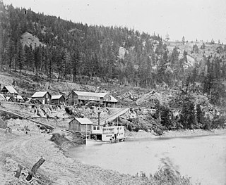
The Enterprise was a passenger and freight sternwheeler that was built for service on the Soda Creek to Quesnel route on the upper Fraser River in British Columbia. It was built at Four Mile Creek near Alexandria by pioneer shipbuilder James Trahey of Victoria for Gustavus Blin-Wright and Captain Thomas Wright and was put into service in the spring of 1863. Her captain was JW Doane. The Enterprise was the first of twelve sternwheelers that would work on this section of the Fraser from 1863 to 1921. Though she wasn’t large, she was a wonderful example of the early craft of shipbuilding. All of the lumber she was built from was cut by hand and her boiler and engines had been brought to the building site at Four Mile packed by mule via the wagon road from Port Douglas, 300 miles away.
Takla Lake is the fifth largest natural lake in British Columbia, Canada. It is a deep fjord-like lake with the Swannell Ranges to the east, the Driftwood River flowing into it from the north, and the Middle River draining it. It is the terminus of the early Stuart-Takla sockeye salmon run, and noted for its large rainbow trout, lake trout and Dolly Varden. The peninsula is the home of Mount Blanchet Provincial Park. Also on the peninsula is a herd of collared woodland caribou, and the winter range of grizzly bears. Two special features are Takla Lake Marine Park, and an Ecological Reserve on the peninsula, a stand of very northerly Douglas Fir. Takla Lake is also the origin of both of Canada's national airlines, both Russ Baker and Grant McConachie running bush plane routes out of Takla Lake. It is a popular canoe route from the top end down to Fort St. James.
The Nazko First Nation is a First Nations government of the Dakelh people in the north-central Interior of British Columbia. Its reserves are located around the community of Nazko, British Columbia, which is 120 km west of Quesnel and southwest of Prince George.
The Takla Range is a small subrange of the Skeena Mountains of the Interior Mountains, bounded by Takla Lake and Northwest Arm in northern British Columbia, Canada.

Middle River, formerly Middle River Village, is an unincorporated settlement at the mouth of the Middle River at its mouth into Trembleur Lake in Omineca Country of the Central Interior of British Columbia, Canada. The community includes Dzitline Lee Indian Reserve 9, which is located on the left bank of the mouth of the Middle River.
Takla Landing, also known as McLaing Landing is an unincorporated locality and former steamboat landing on the east side of Takla Lake in the Omineca Country of the Central Interior of British Columbia, Canada. In the days of the Omineca Gold Rush, Takla Landing was a port for steamboats connecting trails from Hazelton, British Columbia via Babine Lake to trails leading from Takla Landing eastwards to the area of the gold strikes in the lower Omineca River.
Towdystan is an unincorporated settlement and First Nations community of the Dakelh people located northwest of Charlotte Lake in the western Chilcotin District of the Central Interior of British Columbia, Canada. Located southeast of Anahim Lake, the headquarters of the Ulkatcho First Nation government, it includes Towdystan Lake Indian Reserve No. 3, which is one of the Indian Reserves of the Ulkatcho Nation and is located at 52°17′00″N125°07′00″W. The reserve had a population of 10, down 50% from a 2001 figure of 20.
Grand Rapids is a Dakelh community northwest of Fort St. James, British Columbia, Canada, located at the confluence of the Tachie and Kuzkwa Rivers near Trembleur Lake. It is on the site of Kuz Che Indian Reserve No. 5, formerly named Grand Rapide IR No. 5. Nearby [is Tsay Cho IR No. 5, formerly named Stevan IR No. 4. These reserves are under the administration of the Tl'azt'en Nation.
Trembleur Lake is a lake in the Omineca Country of the Central Interior of British Columbia, Canada, northwest of Fort St. James between Stuart Lake and the south end of Takla Lake. It is part of a group of lakes known as the Nechako Lakes. Its name in the Dakelh language (Carrier) is Dzindlat Bun. It has also been known as Cross Lake. Trembleur Lake Provincial Park is located on its north shore, above the Middle River. The reserve settlement of Middle River is located at that river's mouth into Trembleur Lake.

