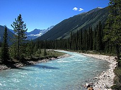
Kootenay National Park is a national park of Canada in southeastern British Columbia. The park consists of 1,406 km2 (543 sq mi) of the Canadian Rockies, including parts of the Kootenay and Park mountain ranges, the Kootenay River and the entirety of the Vermilion River. While the Vermilion River is completely contained within the park, the Kootenay River has its headwaters just outside the park boundary, flowing through the park into the Rocky Mountain Trench and eventually joining the Columbia River. The park ranges in elevation from 918 m (3,012 ft) at the southwestern park entrance to 3,424 m (11,234 ft) at Deltaform Mountain.

The Kootenay River or Kootenai River is a major river of the Northwest Plateau in southeastern British Columbia, Canada, and northern Montana and Idaho in the United States. It is one of the uppermost major tributaries of the Columbia River, the largest North American river that empties into the Pacific Ocean. The Kootenay River runs 781 kilometres (485 mi) from its headwaters in the Kootenay Ranges of the Canadian Rockies, flowing from British Columbia's East Kootenay region into northwestern Montana, then west into the northernmost Idaho Panhandle and returning to British Columbia in the West Kootenay region, where it joins the Columbia at Castlegar.

The Peace River is a 1,923-kilometre-long (1,195 mi) river in Canada that originates in the Rocky Mountains of northern British Columbia and flows to the northeast through northern Alberta. The Peace River joins the Athabasca River in the Peace-Athabasca Delta to form the Slave River, a tributary of the Mackenzie River. The Finlay River, the main headwater of the Peace River, is regarded as the ultimate source of the Mackenzie River. The combined Finlay–Peace–Slave–Mackenzie river system is the 13th longest river system in the world.

Mount Ball is a mountain located on the Continental Divide, on the borders of Banff and Kootenay national parks in Western Canada. Mt. Ball is the highest peak of the Ball Range in the Canadian Rockies.

The Moyie River is a 92-mile (148 km) long tributary of the Kootenai River in the U.S. state of Idaho and the Canadian province of British Columbia. The Moyie River is part of the Columbia River basin, being a tributary of the Kootenay River, which is tributary to the Columbia River.
Simpson River, in Kootenay National Park, is a tributary of Vermilion River flowing through Simpson Valley. Named tributaries include the North Simpson River, Surprise Creek, Lachine Creek, and Verdant Creek. The river's headwaters form on the north slope of Nestor Peak.
The Cross River is a tributary of the Kootenay River in the Canadian province of British Columbia. It is part of the Columbia River basin, as the Kootenay River is tributary to the Columbia River.
Simpson Pass, el. 2,107 m (6,913 ft), is a mountain pass on the border between the Canadian provinces of Alberta and British Columbia, in the area of the Ball Range. It is the prominence col for Mount Ball on the Continental Divide in the vicinity of Sunshine Village ski resort. Simpson River and Simpson Pass are named after Sir George Simpson who first explored the area in 1841.
The Banff-Windermere Highway, also known as the Banff-Windermere Parkway, is a 105 km (65 mi) highway which runs through the Canadian Rockies in British Columbia and Alberta in Canada. It runs from Radium Hot Springs, British Columbia to Castle Junction, Alberta, passing through Kootenay National Park and Banff National Park. It is designated as part of British Columbia Highway 93 and Alberta Highway 93.

The Monarch is a 2,895-metre (9,498-foot) mountain summit located in the Ball Range of the Canadian Rockies in British Columbia, Canada. The Monarch is situated on the boundary between Kootenay National Park and Mount Assiniboine Provincial Park, four kilometres to the west side of the Continental Divide. Although not visible from roads, The Monarch is a prominent feature seen from the slopes above Sunshine Village ski resort. Its nearest higher peak is Mount Bourgeau, 10.35 km (6.43 mi) to the north-northeast.

Hewitt Peak is a 3,066-metre (10,059 ft) mountain summit located on the western border of Kootenay National Park, in the Canadian Rockies of British Columbia, Canada. The peak is also known locally as Mammoth Peak, and originally as Mount 10060. The alternate names derive from its outline profile resembling a mammoth, and its elevation as measured in feet. No name for this mountain has been officially adopted yet. Its nearest higher peak is Tumbling Peak, 2.5 km (1.6 mi) to the north-northwest, and both are part of the Vermilion Range. Park visitors can catch a glimpse of the peak from Highway 93, also known as the Banff–Windermere Highway.

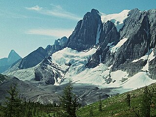
Floe Peak is a 3,006-metre (9,862 ft) mountain summit located on the western border of Kootenay National Park, in the Canadian Rockies of British Columbia, Canada. The name for this mountain has not been officially adopted yet. Its nearest higher peak is Foster Peak, 3.0 km (1.9 mi) to the northwest, and both are part of the Vermilion Range. The mountain is part of what is known as the Rockwall in the Vermilion Range, and is named for Floe Lake which is situated below the enormous northern cliffs of the peak. Floe Lake, one of the beauty spots of Kootenay Park, is accessible via the Floe Lake Trail.

Foster Peak is a 3,204-metre (10,512-foot) mountain summit located on the western border of Kootenay National Park. It is the highest point in the Vermilion Range, a sub-range of the Canadian Rockies of British Columbia, Canada. Its nearest higher peak is Mount Ball, 14.96 km (9.30 mi) to the northeast. The mountain is part of what is known as The Rockwall. Floe Lake, southeast of the peak, is one of the beauty spots of Kootenay National Park. The area is accessible via the Floe Lake Trail and Rockwall Trail. The Rockwall Trail is a scenic 55 kilometre traverse of alpine passes, subalpine meadows, hanging glaciers, and limestone cliffs, in some places in excess of 900 metres above the trail.

Mount Gray is a 2,886-metre (9,469-foot) mountain summit located on the western border of Kootenay National Park in the Vermilion Range, which is a sub-range of the Canadian Rockies in British Columbia, Canada. Its nearest higher peak is Tumbling Peak, 3.1 km (1.9 mi) to the southeast. The mountain is part of what is known as the Rockwall which is an escarpment of the Vermilion Range. The Rockwall Trail is a scenic 55 kilometre traverse of alpine passes, subalpine meadows, hanging glaciers, and limestone cliffs, in some places in excess of 900 m (2,953 ft) above the trail.
Tumbling Peak is a 3,145-metre (10,318-foot) mountain summit located on the western border of Kootenay National Park in the Vermilion Range, which is a sub-range of the Canadian Rockies of British Columbia, Canada. The mountain takes its name from the Tumbling Glacier located on its northeast flank. Its nearest higher peak is Foster Peak, 6.8 km (4.2 mi) to the southeast. Hewitt Peak is also to the southeast, and Mount Gray is to the immediate northwest. The mountain is situated in an area known as the Rockwall, which is an escarpment of the Vermilion Range. The Rockwall Trail is a scenic 55 kilometers traverse of alpine passes, sub-alpine meadows, hanging glaciers, and limestone cliffs, in some places in excess of 900 meters above the trail.

Vermilion Peak is a 2,647-metre (8,684-foot) mountain summit located in the Vermilion River Valley of Kootenay National Park, in British Columbia, Canada. It is part of the Ball Range, which is a sub-range of the Canadian Rockies. Its nearest higher peak is Stanley Peak, 2.8 km (1.7 mi) to the east. Vermilion Peak can be seen from the Banff–Windermere Parkway as it traverses the base of the mountain.
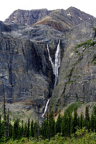
Helmet Falls is a tiered waterfall located in Kootenay National Park in British Columbia, Canada. With total height of 352 metres (1,155 ft), Helmet Falls is the 11th tallest confirmed waterfall in the Canadian Rockies, as well as one of the most significant waterfalls in British Columbia based on both height and volume.

Mount Wardle is a 2,805-metre (9,203-foot) mountain summit located in British Columbia, Canada.

Mount Verendrye is a 3,086-metre (10,125-foot) mountain summit located in British Columbia, Canada.

Mount Shanks is a 2,838-metre (9,311-foot) mountain summit located in British Columbia, Canada.