The Snake River is a major river in the interior Pacific Northwest region of the United States. About 1,080 miles (1,740 km) long, it is the largest tributary of the Columbia River, which is the largest North American river that empties into the Pacific Ocean. Beginning in Yellowstone National Park, western Wyoming, it flows across the arid Snake River Plain of southern Idaho, the rugged Hells Canyon on the borders of Idaho, Oregon and Washington, and finally the rolling Palouse Hills of southeast Washington. It joins the Columbia River just downstream from the Tri-Cities, Washington, in the southern Columbia Basin.

The Cleveland Dam is a 91-metre high (299 ft) concrete dam at the head of the Capilano River in Upper Capilano, North Vancouver, British Columbia, Canada that holds back Capilano Lake, also known as Capilano reservoir. Part of the Capilano River Regional Park, it stores a portion of the Lower Mainland's drinking water. It captures water from one of the three Metro Vancouver watersheds. Construction was started in 1951 and completed in 1954.
The San Lorenzo River is a 29.3-mile-long (47.2 km) river in the U.S. state of California. The name San Lorenzo derives from the Spanish language for "Saint Lawrence" due to its reported sighting on that saint's feast day by Spanish explorers. Its headwaters originate in Castle Rock State Park in the Santa Cruz Mountains and flow south by southeast through the San Lorenzo Valley before passing through Santa Cruz and emptying into Monterey Bay and the Pacific Ocean.

The Elwha River is a 45-mile (72 km) river on the Olympic Peninsula in the U.S. state of Washington. From its source at Elwha snowfinger in the Olympic Mountains, it flows generally north to the Strait of Juan de Fuca. Most of the river's course is within the Olympic National Park.

Burrard Inlet is a shallow-sided fjord in the northwestern Lower Mainland, British Columbia, Canada. Formed during the last Ice Age, it separates the City of Vancouver and the rest of the lowland Burrard Peninsula to the south from the coastal slopes of the North Shore Mountains, which span West Vancouver and the City and District of North Vancouver to the north.

The Coquitlam River is a tributary of the Fraser River in the Canadian province of British Columbia. The river's name comes from the word Kʷikʷəƛ̓əm which translates to "Red fish up the river". The name is a reference to a sockeye salmon species that once occupied the river's waters.

Coyote Creek is a river that flows through the Santa Clara Valley in Northern California. Its source is on Mount Sizer, in the mountains east of Morgan Hill. It eventually flows into Anderson Lake in Morgan Hill and then northwards through Coyote Valley to San Jose, where it empties into San Francisco Bay.

The Homathko River is one of the major rivers of the southern Coast Mountains of the Canadian province of British Columbia. It is one of the few rivers that penetrates the range from the interior Chilcotin Country to the coastal inlets of the Pacific Ocean. The Homathko River reaches the sea at the head of Bute Inlet, just west of the mouth of the Southgate River.

The Bull Run River is a 21.9-mile (35.2 km) tributary of the Sandy River in the U.S. state of Oregon. Beginning at the lower end of Bull Run Lake in the Cascade Range, it flows generally west through the Bull Run Watershed Management Unit (BRWMU), a restricted area meant to protect the river and its tributaries from contamination. The river, impounded by two artificial storage reservoirs as well as the lake, is the primary source of drinking water for the city of Portland, Oregon.

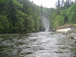
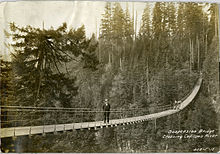
Capilano River Regional Park is located in the District of North Vancouver in British Columbia, Canada. It is one of twenty-three regional parks operated by the Metro Vancouver. The park encompasses most of the upstream areas of the Capilano River below the Cleveland Dam. The area north of the dam surrounding Capilano Lake is closed to the public as it is a GVRD watershed. The privately operated Capilano Suspension Bridge crosses the river, but it is not within park boundaries and does not access the park.

Capilano Lake is a manmade lake located in the District of North Vancouver and West Vancouver in British Columbia, Canada.

The Los Gatos Creek runs 24 miles (39 km) in California through Santa Clara Valley Water District's Guadalupe Watershed from the Santa Cruz Mountains northward through the Santa Clara Valley until its confluence with the Guadalupe River in downtown San Jose. The Guadalupe River then continues onward into San Francisco Bay.

San Leandro Creek is a 21.7-mile-long (34.9 km) year-round natural stream in the hills above Oakland in Alameda County and Contra Costa County of the East Bay in northern California.

The Seymour River is a river in North Vancouver, British Columbia which is notable for being several degrees warmer than other streams and lakes in the area. This is due to it being fed from a large reservoir backed up behind a dam from which a constant flow of water is released. The upper portion of the river and the reservoir are part of the Seymour watershed, controlled by Metro Vancouver.

Santiago Creek is a major watercourse in Orange County in the U.S. state of California. About 34 miles (55 km) long, it drains most of the northern Santa Ana Mountains and is a tributary to the Santa Ana River. It is one of the longest watercourses entirely within the county. The creek shares its name with Santiago Peak, at 5,687 ft (1,733 m) the highest point in Orange County, on whose slopes its headwaters rise.

Salmon Falls Creek is a tributary of the Snake River, flowing from northern Nevada into Idaho in the United States. Formed in high mountains at the northern edge of the Great Basin, Salmon Falls Creek flows northwards 121 miles (195 km), draining an arid and mountainous basin of 2,103 square miles (5,450 km2). The Salmon Falls Creek valley served as a trade route between the Native American groups of the Snake River Plain and Great Basin. Today, most of its water is used for irrigation.
Amon Creek is the largest tributary of the Lower Yakima River in Benton County, Washington. From the source of its East Fork to its mouth at the Yakima, it flows about 13 miles (21 km), passing through Kennewick and Richland. The East Fork as well as the main course north of where both forks come together flow south to north. The West Fork starts in Badger Canyon by heading south, but slowly wraps around along with the topography of the canyon to flow out of it northbound. There is an easily visible riparian zone along most of the length of the main course, along with the West Fork up Badger Canyon and the East Fork until I-82.

Nanaimo River is a river on Vancouver Island, British Columbia, Canada, located near the city of Nanaimo on the island's east coast. Its headwaters are in the Vancouver Island Ranges of central Vancouver Island and its mouth, the Nanaimo River estuary, is at the south end of Nanaimo Harbour in the Strait of Georgia. The estuary is part of the Pacific Estuary Conservation Program.

The Metro Vancouver watersheds, also known as the Greater Vancouver watersheds, supply potable water to approximately 2.7 million residents in the Lower Mainland of British Columbia. They provide tap water to a land area covering more than 2,600 square kilometres (1,000 sq mi), serving a total of 21 member municipalities, one electoral district, and one treaty First Nation. From west to east, the watersheds are the Capilano, the Seymour, and the Coquitlam. They are located in the North Shore Mountains and Coquitlam Mountain, respectively. Each watershed possesses a reservoir for water storage purposes, under the control of Metro Vancouver. The reservoirs are supplied by about 3.5 metres (11 ft) of rain and 4.5 metres (15 ft) of snowpack annually. Two additional off-catchment areas under control of Metro Vancouver contribute to the water supply. The watersheds have a long history of controversies surrounding logging, highway development, and salmon run conservation.