The Chilkat Pass is a mountain pass on the border of Alaska, United States, and the province of British Columbia, Canada, at the divide between the Klehini (S) and Kelsall Rivers just northwest of Haines, Alaska. At an elevation of 3510 ft, it is used by the Haines Highway and was the route used by the Dalton Trail during the days of the Klondike Gold Rush. It also marks the boundary between the Coast Mountains and Saint Elias Mountains.
F.H. Barber Provincial Park is a provincial park in British Columbia, Canada. Comprising 5 ha. of Fraser River floodplain in its natural state, it is one of only two secured public access points to the Fraser between Chilliwack and Hope. It is located at the confluence of Wahleach Creek and the Fraser one mile west of Laidlaw, British Columbia and is bounded on the south by the tracks of the Canadian National Railway.
Kickininee Provincial Park is a provincial park in British Columbia, Canada, located just south of the town of Summerland in that province's Okanagan region. Originally established in 1970 with approximately 7 acres (28,000 m2) of upland and 113.5 acres (0.459 km2) of foreshore, the park today comprises approximately 48.76 ha.
The Lytton First Nation, a First Nations government, has its headquarters at Lytton in the Fraser Canyon region of the Canadian province of British Columbia. While it is the largest of all Nlaka'pamux bands, unlike all other governments of the Nlaka'pamux (Thompson) people, it is not a member of any of the three Nlaka'pamux tribal councils, which are the Nicola Tribal Association, the Fraser Canyon Indian Administration and the Nlaka'pamux Nation Tribal Council.
Taku Harbor is a small, remote bay located on the eastern shore of Stephens Passage about 22 miles southeast of central Juneau, Alaska, United States.
The Inklin River is a river in northern British Columbia, Canada. It flows northwest into the head of the Taku River, which is formed by the convergence of the Inklin with the Nakina River, which flows southwest to meet it at the uninhabited locality of Inklin, which is located at the confluence.
The Nakina River is a river in northwestern British Columbia, Canada, rising southeast of Atlin Lake and flowing generally southeast to its confluence with the Inklin River at the locality of Inklin, where the two rivers combine to form the Taku River.
The Stikine Plateau is a plateau in northern British Columbia, Canada. It lies between the Boundary Ranges of the Coast Mountains on the west and southwest and the Cassiar Mountains along its northeast, and between the Skeena Mountains on its south and southeast and the Jennings and Nakina Rivers on the north.

Tulsequah is an unincorporated locality in northwestern, British Columbia, Canada, located at the confluence of the Taku and Tulsequah Rivers. The Tulsequah Chief Mine is located nearby, about ten miles up the Tulsequah River.

The Whiting River is a stream, about 50 miles (80 km) long, in the U.S. state of Alaska and the Canadian province of British Columbia. It enters the waters of Stephens Passage at the Borough of Juneau in the Alaska Panhandle between the mouths of the Taku and Stikine Rivers. The main tributary of the Whiting is the South Whiting. The river's basin is at the northern end of the Stikine Icecap The river crosses the international boundary at 58°11′00″N133°13′00″W. Its origin is in the Chechidla Range, and its terminus is at Gilbert Bay, which empties into Stephens Passage. In 1888, Lieutenant Commander C. M. Thomas of the U.S. Navy (USN) named the river for assistant surgeon Robert Whiting, USN, a member of his surveying party.
The Cadwallader Range, originally named the Cadwallader Mountains, is a sub-range of the Pacific Ranges of the Coast Mountains in the Bridge River-Lillooet Country of the South-Central Interior of British Columbia, Canada, located between the south end of Anderson Lake (E) and the Hurley River. According to the provincial basemap, the precise alpine boundaries of the range are McGilliray Pass, at its eastern extremity and beyond which is the Bendor Range, and the pass between Noel and Sockeye Creeks on its west, which is immediately north of the lower end of Birkenhead Lake. The officially unnamed range west of that has been called the Noel Range, after its main peak Mount Noel. At the foot of the range along its northeast flank is Cadwallader Creek, scene of the historic and once-rich Bralorne and Pioneer Mines and the ghost town of Bralorne.
The Taku River Tlingit First Nation are the band government of the Inland Tlinkit in far northern British Columbia, Canada and also in Yukon. They comprise two ḵwaan (tribes) of the Tlingit people, who are otherwise coastal, the Áa Tlein Ḵwáan of the Atlin Lake area and the Deisleen Ḵwáan of Teslin Lake, whose main focus is the Teslin Tlingit Council in Teslin, Yukon. Their band offices are in Atlin, British Columbia.
The Tseycum First Nation is a First Nations government located on Vancouver Island. In the 1850s they were signatories to the Douglas Treaties.
The Smith River is a river in the Yukon Territory and the province of British Columbia, Canada, arising in the Yukon at 60°09′N126°18′W and crossing the border to enter British Columbia at 60°00′00″N126°23′25″W to its confluence with the Liard River at 59°33′00″N126°29′00″W, between the confluences of the Toad and Coal Rivers. At the confluence is the site of the former Hudson's Bay Company trading post, Fort Halkett, and also Smith River Falls, which are jointly protected by Smith River Falls-Fort Halkett Provincial Park.
Snettisham is a locale and former populated place in the City and Borough of Juneau, Alaska, United States. Based on the mainland coast of Stephens Passage, it is 31 miles (50 km) southeast of the city of Juneau. The area was named by George Vancouver in 1794; the bay on which Snettisham was located was named for the town of Snettisham in England. It was established as a gold- and silver-mining camp around 1895, its operations being linked to those in the immediate Juneau area, and it remained a small harbor village until 1926. The United States Department of the Treasury designated Snettisham as one of several of Alaska's "special" landing places for vessels carrying "coal, salt, railroad iron, and other like items in bulk". The designation was meant to encourage the construction of facilities to accommodate these shipments, thus stimulating creation and growth of local businesses.

The Stikine Region is an unincorporated area in northwesternmost British Columbia, Canada and is the only area in B.C. not in a regional district. The Stikine Region was left unincorporated following legislation that established the province's regional districts in 1968 and is not classified as a regional district. It contains no municipal governments which normally constitute the majority of seats on the boards of regional districts. There is only one local planning area, the Atlin Community Planning Area, which was combined in 2009 with the Atlin Community Improvement District to provide fire, landfill, water, streetlighting, sidewalks and advisory land use services. All other services not provided privately are administered directly by various provincial government ministries. The area around Dease Lake, formerly in the Stikine Region, is now within the boundaries of the Regional District of Kitimat-Stikine following a boundary amendment in 2008.

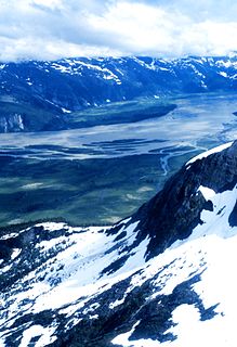
Taku Inlet is an inlet located in the U.S. state of Alaska. It extends 18 miles (29 km) in a northeast direction from Stephens Passage in the Alexander Archipelago, about 12 kilometres (7.5 mi) southeast of Juneau, widening to a basin where discharge from the Taku River and Taku Glacier emerges.
King Salmon Creek is a creek in the Atlin District of British Columbia, Canada. The creek begins at King Salmon Lake and flows generally eastward to join the Taku River. Southeast of that confluence is King Salmon Mountain.