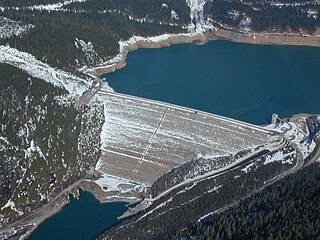
Mica Dam is a hydroelectric embankment dam spanning the Columbia River 135 kilometres north of Revelstoke, British Columbia, Canada. It was built as one of three Canadian projects under the terms of the 1964 Columbia River Treaty and is operated by BC Hydro. Completed in 1973, the Mica powerhouse had an original generating capacity of 1,805 megawatts (MW). Mica Dam, named after the nearby settlement of Mica Creek and its associated stream, in turn named after the abundance of mica minerals in the area, is one of the largest earthfill dams in the world. The reservoir created by the dam is Kinbasket Lake. Water from the dam flows south directly into Revelstoke Lake, the reservoir for the Revelstoke Dam. Mica Dam is the tallest dam in Canada and second tallest in North America after the Chicoasén Dam in Mexico and it is the farthest upstream dam on the Columbia River. The dam's underground powerhouse was the second largest in the world at the time of its construction, and was the first 500 kV installation of sulphur hexafluoride (SF6) insulated switchgear in the world.

Kootenay Lake is a lake located in British Columbia, Canada. It is part of the Kootenay River. The lake has been raised by the Corra Linn Dam and has a dike system at the southern end, which, along with industry in the 1950s–70s, has changed the ecosystem in and around the water. The Kootenay Lake ferry is a year-round toll-free ferry that crosses between Kootenay Bay and Balfour. The lake is a popular summer tourist destination.
Coquitlam Lake is a reservoir located just north of Coquitlam, British Columbia. It is one of the three main water sources for Metro Vancouver, and part of the Coquitlam watershed. It is also a part of BC Hydro's power generation system. A tunnel directs water from the lake to nearby Buntzen Lake, and from there to a pair of power stations.

Garibaldi Provincial Park, also called Garibaldi Park, is a wilderness park located on the coastal mainland of British Columbia, Canada, 70 kilometres (43.5 mi) north of Vancouver. It was established in 1920 and named a Class A Provincial Park of British Columbia in 1927. The park is a popular destination for outdoor recreation, with over 30,000 overnight campers and over 106,000 day users in the 2017/2018 season.
Dease Lake is a small community in the Cassiar Country of the Northern Interior of British Columbia, Canada. It is 230 km south of the Yukon border on Stewart–Cassiar Highway at the south end of the lake of the same name. Dease Lake is the last major centre before the Alaska Highway while driving northbound, and also the junction to Telegraph Creek and the Grand Canyon of the Stikine. Dease Lake Indian Reserve No. 9 is nearby and is under the governance of the Tahltan First Nation band government.

Allison Pass is a highway summit along the Crowsnest Highway in British Columbia, Canada. It is the highest point on the section of highway between the cities of Hope and Princeton. It is located in the middle of Manning Park, at the divide between the Skagit & Similkameen River drainages, as well as on the boundary between the Fraser Valley and Okanagan-Similkameen Regional Districts, approximately 12 km (7 mi) west of the Manning Resort and 54 km (34 mi) from Hope. The Skagit River originates at the pass while the Similkameen River originates just north of it.

The Cheakamus River is a tributary of the Squamish River, beginning at the terminus of McBride Glacier on Mount Sir Richard in Garibaldi Provincial Park upstream from Cheakamus Lake on the southeastern outskirts of the resort area of Whistler. The river flows into Cheakamus Lake before exiting it and flowing northwest until it turns south and enters Daisy Lake. Between the outlet of Daisy Lake and its mouth, much of its length is spent going through Cheakamus Canyon, where the river flows through swift rapids and even one good sized waterfall. The river flows south from the lake and through the canyon before joining the Squamish River at Cheekye, a few miles north of the town of Squamish. The river's name is an anglicization of the name of Chiyakmesh, a village of the Squamish people and a reserve of the Squamish Nation.

British Columbia is the westernmost province of Canada, bordered by the Pacific Ocean. With an area of 944,735 km2 (364,764 sq mi) it is Canada's third-largest province. The province is almost four times the size of the United Kingdom and larger than every United States state except Alaska. It is bounded on the northwest by the U.S. state of Alaska, directly north by Yukon and the Northwest Territories, on the east by Alberta, and on the south by the U.S. states of Washington, Idaho, and Montana. Formerly part of the British Empire, the southern border of British Columbia was established by the 1846 Oregon Treaty. The province is dominated by mountain ranges, among them the Canadian Rockies but dominantly the Coast Mountains, Cassiar Mountains, and the Columbia Mountains. Most of the population is concentrated on the Pacific coast, notably in the area of Vancouver, located on the southwestern tip of the mainland, which is known as the Lower Mainland. It is the most mountainous province of Canada.

Stave Lake is a lake and reservoir for the production of hydroelectricity in the Stave River system, located on the northern edge of the District of Mission, about 65 km (40 mi) east of Vancouver, British Columbia, Canada. The main arm of the lake is about 20 km (12 mi) long from north to south and its southwest arm, ending at Stave Falls Dam near Stave Falls, is about 9.5 km (5.9 mi) long. The total area of the lake currently is about 55 square kilometres. Prior to construction of the dam, the lake was about one-third the size of its current main arm.

Kwadacha, also known as Fort Ware or simply Ware, is an aboriginal community in northern British Columbia, Canada, located in the Rocky Mountain Trench at the confluence of the Finlay, Kwadacha and Fox Rivers, in the Rocky Mountain Trench upstream from the end of the Finlay Reach of Williston Lake. The population is about 350. It is in the federal electoral riding of Prince George-Peace River.
Kemano was a settlement situated 75 km (47 mi) southeast of Kitimat in the province of British Columbia in Canada. It was built to service a hydroelectric power station, built to provide energy for Alcan to smelt aluminum from its ore. The Kemano Generating Station is built 427 m (1,400 ft) inside the base of Mt Dubose in a blasted cavern. It produces 896 MW of power from its eight generators, each of which has a capacity of 112MW.
The Callaghan Valley is located in the Sea to Sky Country of southwestern, British Columbia, in the Pacific Ranges of the Coast Mountains 90 km north of Vancouver. It was the home of the 2010 Winter Olympics's Whistler Olympic Park, the venue for the Nordic events of the Olympics, and adventure tourism operations including Canadian Wilderness Adventures.

Buntzen Lake is a 4.8 kilometres (3 mi) long lake in Anmore, British Columbia, Canada, in the Greater Vancouver area. It is named after the first general manager of the B.C. Electric Co., Johannes Buntzen. There is a smaller lake just to the north named McCombe Lake.
The Nechako Reservoir, sometimes called the Ootsa Lake Reservoir, is a hydroelectric reservoir in British Columbia, Canada that was formed by the Kenney Dam making a diversion of the Nechako River through a 16-km intake tunnel in the Kitimat Ranges of the Coast Mountains to the 890 MW Kemano Generating Station at sea level at Kemano to service the then-new Alcan aluminum smelter at Kitimat. When it was constructed on the Nechako River in 1952, it resulted in the relocation of over 75 families. It was one of the biggest reservoirs built in Canada until the completion of the Columbia Treaty Dams and the W.A.C. Bennett Dam that created Lake Williston. The water level may swing 10 feet between 2790 and 2800 feet.

Rubble Creek is a creek in southwestern British Columbia, Canada. It flows northwest from Garibaldi Lake into the Cheakamus River near the abandoned settlement of Garibaldi.
Alouette Lake, originally Lillooet Lake and not to be confused with the lake of that name farther north, is a lake and reservoir in Maple Ridge, British Columbia, Canada. It is located at the southeast foot of the mountain group known as the Golden Ears and is about 16 km in length on a northeast–southwest axis. It and the Alouette River, formerly the Lillooet River, were renamed in 1914 to avoid confusion with the larger river and lake farther north, with "Alouette", the French word for "lark", being chosen as being melodious and reminiscent of the original name in tone.
The Clowhom River is a short, 19.8-kilometre (12.3 mi) river in British Columbia. It flows into the head of the Salmon Inlet about 26.2 km west of Squamish.
Clowhom Lake is a reservoir in the Sechelt Inlet basin, located on the Clowhom River at the upper end of Salmon Inlet, the southern side-inlet of Sechelt Inlet. Formed by Clowhom Dam, the reservoir was formerly two lakes, Upper Clowhom Lake and Lower Clowhom Lake, and had been referred to prior to their merger from inundation as the Clowhom Lakes.
The Cheslatta River is a tributary of the Nechako River, one of the main tributaries of the Fraser River, in the Canadian province of British Columbia. It flows through the Nechako Plateau. Before the construction of Kenney Dam in the early 1950s the Cheslatta was a minor tributary of the Nechako. Today the Nechako River is dry above the Cheslatta, which provides all its source water.

