San Josef Bay

Last updated
San Josef Bay
Canada British Columbia relief location map.jpg
Red pog.svg
San Josef Bay
Location of San Josef Bay in British Columbia
Location Vancouver Island, British Columbia
Coordinates 50°39′24″N128°18′53″W / 50.65667°N 128.31472°W / 50.65667; -128.31472
Type Bay
River sourcesSan Josef River
Ocean/sea sources Pacific Ocean

San Josef Bay is a bay on the northwest coast of Vancouver Island, in the province of British Columbia, Canada. [1] [2]

Contents

It is located on the western coast of Vancouver Island between Cape Russell, [3] or Hanna Point, [4] and Cape Palmerston. [5] [2] The bay is about 15 km (9.3 mi) south of Cape Scott, the northwestern extremity of Vancouver Island, and about 34 km (21 mi) north of Quatsino Sound. The distance from San Josef Bay to Nanaimo is about 350 km (220 mi), and about 350 km (220 mi) to Victoria, and 350 km (220 mi) to Vancouver. [6] [7] [8] [9]

San Josef Bay is within the traditional territory of two First Nations, the Tlatlasikwala Nation, [10] [11] and the Quatsino First Nation. [12]

Name

The bay's name "San Josef" first appears on a 1793 chart made by the Spanish naval officer Dionisio Alcalá Galiano. In 1792 Galiano circumnavigated Vancouver Island with Cayetano Valdés y Flores and in cooperation with George Vancouver. The name refers to Saint Joseph, the husband of Mary, mother of Jesus. [1] Unbeknownst to Galiano, the maritime fur trader James Hanna had named the bay St. Patrick's Bay during his second voyage to the area in 1786. Hanna also named the San Josef River "Parry River". Another maritime fur trader who visited in 1786, James Strange, named San Josef Bay "Scott’s Bay", after his friend and patron David Scott, who is commemorated by nearby Cape Scott and Scott Islands. [1]

Geography

Most of the San Josef Bay and much of the land around it is within Cape Scott Provincial Park. The San Josef River flows into the east end of San Josef Bay. [13] Jensen Creek also empties into the bay very close to the mouth of the San Josef River. [14] There are a number of small islands in San Josef Bay, including Kelley Island. [15] Just west of Hanna Point are the Helen Islands and Winifred Islands. [16] [17] [6] [8] [7]

Mount St. Patrick lies on the northern shore of San Josef Bay, [18] just east of Sea Otter Cove. [19] [6] [8] [7]

Cape Scott Provincial Park can be accessed near the mouth of the San Josef River via a road from the community of Holberg, about 20 km (12 mi) east of San Josef Bay. [9] Holberg is located at the end of Holberg Inlet, part of Quatsino Sound. [6] [8] [7]

The Indian reserve "Semach 2", of the Kwakwakaʼwakw Tlatlasikwala Nation, associated with the Kwakiutl District Council, is located near Hanna Point and the entrance to Sea Otter Cove. [20] [6] [8] [21]

History

Before Western contact in the late 18th century, the Cape Scott area was inhabited by three Kwakwakaʼwakw indigenous peoples, the Tlatlasikwala (T̕łat̕łasik̕wala), Nakumgilisala (Nakomgilisala), and Yutlinuk. By the early 19th century the Yutlinuk had ceased to exist as a separate people, with survivors merging with the Tlatlasikwala. In the mid-1850s the Tlatlasikwala and Nakumgilisala merged and moved to Hope Island, where they remained until 1954, at which time their population had dropped to just 32 individuals. In 1954 they joined with the Koskimo (Quatsino) people and moved to the Quatsino Sound area. [22] Before 1985 they were known as the Nuwitti or Nahwitti, and today Tlatlasikwala. [23]

In the late 18th century the San Josef Bay area was visited by two of the first maritime fur traders, who were among the earliest Western visitors to the Pacific Northwest coast after Captain James Cook. The first maritime fur trading ship captain to visit the coast, James Hanna, traded for sea otter furs at Nootka Sound in 1785 and made a considerable profit. His backers funded a second voyage in 1786, but when Hanna arrived at Nootka Sound he discovered that a second maritime fur trader, James Strange, had already been there and collected most of the sea otter furs available. So Hanna sailed Sea Otter north, in the process finding San Josef Bay. He named it St. Patrick's Bay. This name survives as the name of Mount St. Patrick on the northern shore of the bay. Hanna also gave Sea Otter Cove its present name, after his ship Sea Otter. [24]

James Strange also sailed north from Nootka Sound, finding San Josef Bay as well and naming it Scott's Bay, a name which survives in some nearby place names, such as Cape Scott. By the 1790s, as the maritime fur trade boomed, indigenous peoples of the Pacific Northwest Coast focused the trade to certain places by bringing sea otter furs from a large area to a central trading site. For the San Josef Bay area, which was Kwakwakaʼwakw territory, this trading site was Nahwitti, around Cape Scott on the northernmost coast of Vancouver Island. Nahwitti was under the control of the Kwakwakaʼwakw Tlatlasikwala Nation.

San Josef Bay, and nearby areas like Sea Otter Cove, were prime sea otter habitat. By the early 19th century sea otters had been hunted to local extinction.

Related Research Articles

<span class="mw-page-title-main">Vancouver Island</span> Largest island in British Columbia, Canada

Vancouver Island is an island in the northeastern Pacific Ocean and part of the Canadian province of British Columbia. The island is 456 km (283 mi) in length, 100 km (62 mi) in width at its widest point, and 32,100 km2 (12,400 sq mi) in total area, while 31,285 km2 (12,079 sq mi) are of land. The island is the largest by area and the most populous along the west coasts of the Americas.

<span class="mw-page-title-main">Quadra Island</span> Island in British Columbia, Canada

Quadra Island is a large island off the eastern coast of Vancouver Island, in British Columbia, Canada. It is part of the Discovery Islands, in the Strathcona Regional District.

<span class="mw-page-title-main">Wakashan languages</span> Native American language family

Wakashan is a family of languages spoken in British Columbia around and on Vancouver Island, and in the northwestern corner of the Olympic Peninsula of Washington state, on the south side of the Strait of Juan de Fuca.

<span class="mw-page-title-main">Cape Scott Provincial Park</span> Provincial park

Cape Scott Provincial Park extends from Shushartie in the east, then westward around Cape Scott and south to San Josef Bay. This coastline comprises the northern tip of Vancouver Island, British Columbia. The 22,294-hectare (55,090-acre) provincial park is about 563 km (350 mi) northwest of Victoria.

<span class="mw-page-title-main">Raft Cove Provincial Park</span> Provincial Park in British Columbia, Canada

Raft Cove Provincial Park is a provincial park in British Columbia, Canada, located south of San Josef Bay on northwestern Vancouver Island.

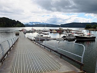
Holberg is a former ferry terminal about 35 kilometres (22 mi) from the northwest tip of Vancouver Island, British Columbia. This unincorporated community is at the head of Holberg Inlet, which forms the western arm of Quatsino Sound.

<span class="mw-page-title-main">Dionisio Alcalá Galiano</span> Spanish naval officer

Dionisio Alcalá Galiano was a Spanish naval officer, cartographer, and explorer. He mapped various coastlines in Europe and the Americas with unprecedented accuracy using new technology such as chronometers. He commanded an expedition that explored and mapped the Strait of Juan de Fuca and the Strait of Georgia, and made the first European circumnavigation of Vancouver Island. He reached the rank of brigadier and died during the Battle of Trafalgar.

<span class="mw-page-title-main">North Coast Trail</span> Hiking trail on Vancouver Island, British Columbia, Canada

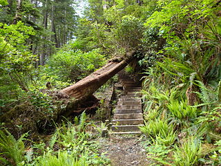
The North Coast Trail is a 43.1 km (26.8 mi) wilderness hiking trail in Cape Scott Provincial Park on northern Vancouver Island, British Columbia, Canada.

<span class="mw-page-title-main">Charles William Barkley</span>

Charles William Barkley was a ship captain and maritime fur trader. He was born in Hertford, England, son of Charles Barkley.

<span class="mw-page-title-main">Quatsino Sound</span> Body of water on the coast of Vancouver Island in British Columbia, Canada

Quatsino Sound is a complex of coastal inlets, bays and islands on northwestern Vancouver Island in the Canadian province of British Columbia. It is the northernmost of the five sounds that pierce the west coast of Vancouver Island, the others being Kyuquot Sound, Nootka Sound, Clayoquot Sound, and Barkley Sound.

<span class="mw-page-title-main">Maritime fur trade</span> Ship-based fur-trade system

The maritime fur-trade, a ship-based fur-trade system, focused largely on acquiring furs of sea otters and other animals from the indigenous peoples of the Pacific Northwest Coast and natives of Alaska. Entrepreneurs also exploited fur-bearing skins from the wider Pacific and from the Southern Ocean.

James Hanna was the first European to sail to the Pacific northwest to trade in furs. This maritime fur trade was an important factor in the early history of the Pacific Northwest and the westward expansion of the United States and Canada.

<span class="mw-page-title-main">James Charles Stuart Strange</span> British politician

James Charles Stuart Strange was a British officer of the East India Company, one of the first maritime fur traders, a banker, and a Member of Parliament.

Union was an American sloop built in Somerset, Massachusetts in 1792. It is best known for its circumnavigation of the world, 1794–1796, under the maritime fur trader John Boit.

<span class="mw-page-title-main">Checleset Bay</span> Bay in British Columbia, Canada

Checleset Bay is a bay on the northwest coast of Vancouver Island, British Columbia, Canada. It is located southeast of Brooks Peninsula and northwest of Kyuquot Sound. Much of the land around the bay is part of Brooks Peninsula Provincial Park. Checleset Bay has three large inlets, Nasparti Inlet, Ououkinsh Inlet, and Malksope Inlet.

John Boit Jr was one of the first Americans involved in the maritime fur trade. He sailed as fifth mate under Captain Robert Gray on the second voyage of the Columbia Rediviva, 1790–1793. During the voyage he wrote a short but important journal in which he described the discovery of the Columbia River.

The Nahwitti River is a 40-kilometre (25 mi) long river in northernmost Vancouver Island, British Columbia, Canada. It flows through Cape Scott Provincial Park into Goletas Channel near Hope Island and Queen Charlotte Sound. Its watershed, 229 km2 (88 sq mi) large, is located west and northwest of Port Hardy, north and northeast of Holberg, and north of Holberg Inlet, part of Quatsino Sound.

<span class="mw-page-title-main">Nahwitti (trading site)</span>

Nahwitti was a Kwakwakaʼwakw First Nation village and a major trading site during the maritime fur trade era of approximately 1790 to 1850. Today it is an Indian reserve under the administration of the Kwakwakaʼwakw Tlatlasikwala Nation. It is located near the northern tip of Vancouver Island, at Cape Sutil on Queen Charlotte Sound, near Hope Island and the Nahwitti River, east of Cape Scott, and not far from historic Fort Rupert and modern Port Hardy.

Cape Sutil is the headland at the northernmost point of Vancouver Island, in the Canadian Province of British Columbia.

Goletas Channel is a channel and strait on the north side of Vancouver Island in British Columbia, Canada. It separates Vancouver Island from Hope Island and Nigei Island, located just east of Cape Sutil, the northernmost point of Vancouver Island. The waters of Goletas Channel are part of northern Queen Charlotte Strait.

References

  1. 1 2 3 "San Josef Bay". BC Geographical Names .
  2. 1 2 "San Josef Bay". Geographical Names Data Base . Natural Resources Canada.
  3. "Cape Russell". BC Geographical Names .
  4. "Hanna Point". BC Geographical Names .
  5. "Cape Palmerston". BC Geographical Names .
  6. 1 2 3 4 5 Canada Surveys and Mapping Branch (1976). San Josef, Rupert Land District, British Columbia; NTS 102I/09 (PDF) (Topographic map) (3rd ed.). 1:50:000. National Topographic System (in English and French). Department of Energy, Mines and Resources . Retrieved 25 January 2024 via GEOSCAN.
  7. 1 2 3 4 Backroad Mapbooks (2021). Vancouver Island North, British Columbia (Topographic map). 1:180,000. Adventure Topographic Maps. In partnership with Recreation Sites and Trails BC. Mussio Ventures. ISBN   978-1-989175-18-7.
  8. 1 2 3 4 5 "The Atlas of Canada - Toporama". Natural Resources Canada . Retrieved 25 January 2024.
  9. 1 2 Measurements made using BCGNIS coordinates, topographic maps, and The Atlas of Canada - Toporama
  10. "Tlatlasikwala First Nation". Tlatlasikwala First Nation. Retrieved 25 January 2024.
  11. "Tlatlasikwala Nation". BC Treaty Commission. Retrieved 25 January 2024.
  12. "Lands". Quatsino First Nation. Retrieved 25 January 2024.
  13. "San Josef River". BC Geographical Names .
  14. "Jensen Creek". BC Geographical Names .
  15. "Kelley Island". BC Geographical Names .
  16. "Helen Islands". BC Geographical Names .
  17. "Winifred Islands". BC Geographical Names .
  18. "Mount St. Patrick". BC Geographical Names .
  19. "Sea Otter Cove". BC Geographical Names .
  20. "Semach 2". BC Geographical Names .
  21. "Semach 2 Indian Reserve". Crown–Indigenous Relations and Northern Affairs Canada . Government of Canada. Retrieved 25 January 2024.
  22. "Cape Scott Park". BC Parks . Retrieved 25 January 2024.
  23. "Tlatlasikwala". British Columbia Assembly of First Nations. Retrieved 25 January 2024.
  24. Akrigg, G.P.V; Akrigg, Helen B. (1997). British Columbia Place Names. University of British Columbia Press. p. 238. ISBN   9780774806374 . Retrieved 26 January 2024.