The W. A. C. Bennett Dam is a large hydroelectric dam on the Peace River in northern British Columbia, Canada. At 186 metres (610 ft) high, it is one of the world's highest earth fill dams. Construction of the dam began in 1961 and culminated in 1968. At the dam, the Finlay, the Parsnip and the Peace rivers feed into Williston Lake, also referred to as Williston Reservoir. It is the third largest artificial lake in North America as well as the largest body of fresh water in British Columbia. Williston Lake runs 250 kilometres north–south and 150 kilometres east–west.
The British Columbia Hydro and Power Authority, operating as BC Hydro, is a Canadian electric utility in the province of British Columbia. It is the main electricity distributor, serving more than 4 million customers in most areas, with the exception of the City of New Westminster, where the city runs its own electrical department and portions of the West Kootenay, Okanagan, the Boundary Country and Similkameen regions, where FortisBC, a subsidiary of Fortis Inc. directly provides electric service to 213,000 customers and supplies municipally owned utilities in the same area. As a provincial Crown corporation, BC Hydro reports to the BC Ministry of Energy, Mines and Low Carbon Innovation, and is regulated by the British Columbia Utilities Commission (BCUC). Its mandate is to generate, purchase, distribute and sell electricity.
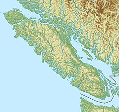
Campbell River is a city in British Columbia, Canada, on the east coast of Vancouver Island at the south end of Discovery Passage, which lies along the 50th parallel north along the important Inside Passage shipping route. Campbell River has a population of 32,588 and has long been touted as the "salmon capital of the world." Campbell River and Region are near the communities of Quadra and the Discovery Islands, Sayward, Oyster River, Gold River, Tahsis and Zeballos.
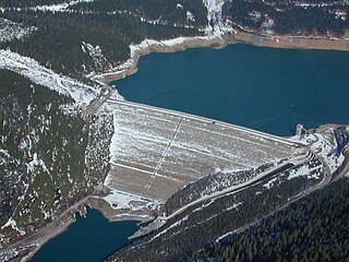
Mica Dam is a hydroelectric embankment dam spanning the Columbia River 135 kilometres north of Revelstoke, British Columbia, Canada. It was built as one of three Canadian projects under the terms of the 1964 Columbia River Treaty and is operated by BC Hydro. Completed in 1973, the Mica powerhouse had an original generating capacity of 1,805 megawatts (MW). Mica Dam, named after the nearby settlement of Mica Creek and its associated stream, in turn named after the abundance of mica minerals in the area, is one of the largest earthfill dams in the world. The reservoir created by the dam is Kinbasket Lake. Water from the dam flows south directly into Revelstoke Lake, the reservoir for the Revelstoke Dam. Mica Dam is the tallest dam in Canada and second tallest in North America after the Chicoasén Dam in Mexico and it is the farthest upstream dam on the Columbia River. The dam's underground powerhouse was the second largest in the world at the time of its construction, and was the first 500 kV installation of sulphur hexafluoride (SF6) insulated switchgear in the world.

Revelstoke Dam, also known as Revelstoke Canyon Dam, is a hydroelectric dam spanning the Columbia River, 5 km (3.1 mi) north of Revelstoke, British Columbia, Canada. The powerhouse was completed in 1984 and has an installed capacity of 2480 MW. Four generating units were installed initially, with one additional unit (#5) having come online in 2011. The reservoir behind the dam is named Lake Revelstoke. The dam is operated by BC Hydro.

Hugh Keenleyside Dam is a flood control dam spanning the Columbia River, 12 km upstream of the city of Castlegar, British Columbia, Canada.

The Peace River is a 1,923-kilometre-long (1,195 mi) river in Canada that originates in the Rocky Mountains of northern British Columbia and flows to the northeast through northern Alberta. The Peace River joins the Athabasca River in the Peace-Athabasca Delta to form the Slave River, a tributary of the Mackenzie River. The Finlay River, the main headwater of the Peace River, is regarded as the ultimate source of the Mackenzie River. The combined Finlay–Peace–Slave–Mackenzie river system is the 13th longest river system in the world.

The Bridge River is an approximately 120 kilometres (75 mi) long river in southern British Columbia. It flows south-east from the Coast Mountains. Until 1961, it was a major tributary of the Fraser River, entering that stream about six miles upstream from the town of Lillooet; its flow, however, was near-completely diverted into Seton Lake with the completion of the Bridge River Power Project, with the water now entering the Fraser just south of Lillooet as a result.
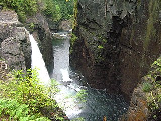
Elk Falls Provincial Park is a provincial park in British Columbia, Canada. It is 1,807 hectares in size and is located at the east end of John Hart Lake on the northwest side of the city of Campbell River, on Vancouver Island.

Strathcona Provincial Park is the oldest provincial park in British Columbia, Canada, and the largest on Vancouver Island. Founded in 1911, the park was named for Donald Alexander Smith, 1st Baron Strathcona and Mount Royal, a wealthy philanthropist and railway pioneer. It lies within the Strathcona Regional District. The Clayoquot Sound Biosphere Reserve, established in 2000, includes three watersheds in the western area of the park.

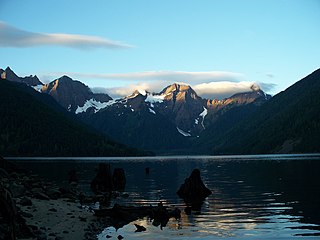
Buttle Lake is a lake on Vancouver Island in Strathcona Regional District, British Columbia, Canada. It is about 23 kilometres (14 mi) long and 1.5 kilometres (0.9 mi) wide, has an area of 28 square kilometres (11 sq mi), is up to 120 metres (394 ft) deep, and lies at an elevation of 221 metres (725 ft). The lake is located between Campbell River and Gold River in Strathcona Provincial Park. The lake is the headwaters of the Campbell River.
FortisBC is a Canadian owned, British Columbia based regulated utility providing natural gas, and electricity. FortisBC has approximately 2,600 employees serving more than 1.2 million customers in 135 B.C. communities and 58 First Nations communities across 150 Traditional Territories.

The Jordan River Dam, officially the Jordan River Diversion Dam, and known locally simply as Diversion Dam, is a dam located in Jordan River, British Columbia, Canada. It is part of the second hydroelectric development on Vancouver Island.
According to the International Hydropower Association, Canada is the fourth largest producer of hydroelectricity in the world in 2021 after the United States, Brazil, and China. In 2019, Canada produced 632.2 TWh of electricity with 60% of energy coming from Hydroelectric and Tidal Energy Sources).
Campbell Island is an island in the Canadian province of British Columbia, located west of Denny Island and north of Hunter Island, near Milbanke Sound. The Inside Passage waterways of Lama Passage and Seaforth Channel meet at its northern end.
Wahleach Lake, commonly known as Jones Lake, is a lake and reservoir located in the Skagit Range in the Lower Mainland of British Columbia, Canada, east of the city of Chilliwack and southwest of the town of Hope.

The Kootenay Canal is a hydroelectric power station, located 19 km downstream of Nelson, British Columbia, Canada. Where the Kootenay River flows out of the reservoir formed by the Corra Linn Dam on Kootenay Lake., a canal diverts water to BC Hydro's Kootenay Canal Generating Station. Its construction was a result of the Duncan Dam and Libby Dam providing year round flows into Kootenay Lake. The powerhouse was completed in 1976.
The John Hart Dam is one of three hydroelectric dams on the Campbell River, located on Vancouver Island in British Columbia, Canada. The dam is located at the outflow of John Hart Lake. The John Hart Generating Station is located nearby.
John Hart Lake is a reservoir on Vancouver Island in British Columbia, Canada. The lake was created in 1947 when the John Hart Dam impounded the Campbell River, and is the water source for the city of Campbell River. The Campbell River flows from the lake at the John Hart Dam and via the John Hart generating station. The lake has an area of 362.6 ha, with a mean depth of 12.2 metres (40 ft) to a maximum of 22.9 metres (75 ft). The lake is named for John Hart, a Canadian politician who was the 23rd Premier of British Columbia.