Kildonan, British Columbia

Last updated

Kildonan
People at Kildonan Post Office.jpg
Kildonan Post Office
CountryCanada
Province British Columbia
Regional district Alberni-Clayoquot
Time zone UTC-8 (PST)
  Summer (DST) UTC-7 (PDT)

Kildonan is an unincorporated community in the Alberni Inlet-Barkley Sound region of the west coast of southern Vancouver Island, British Columbia. The former steamboat landing and ferry dock is on the east shore of Uchuchklesit Inlet, which branches northwest of the lower reaches of Alberni Inlet. [1] Adjacent to Pacific Rim National Park Reserve, the locality is by road and ferry about 120 kilometres (75 mi) southwest of Port Alberni.

Contents

Cannery

In 1903, captains Macdonald and Terman established the Alberni Packing Co. [2] Creating the first cannery on the west coast of Vancouver Island, the company erected the Uchucklesaht Cannery on pilings. [3] [4] Purchased by Wallace Bros. Packing in 1906, [5] or soon after, [2] owners, Peter and John Wallace, renamed the cannery after their Scottish hometown of Kildonan. [3] Reorganized as Wallace Fisheries in 1911, [6] the company began a complete rebuild, and added a large cold storage [7] in 1913. [3] Such expansions increased the demand for seasonal workers, and the accommodation of bunkhouses for single men and cottages for families. [8]

In 1919, when Wallace Fisheries approached W.H. Barker, manager of British Columbia Packers Limited (BC Packers), to take over their Kildonan, Strathcona, Caxton, Quatsino and Naden Harbour canneries, his disinterest in the latter two, because they were exclusively designed for pink and chum salmon, scuttled any deal. [9]

In 1925, pilchards suddenly appeared in abundance along the coast, leading to a three-year fishing boom. [10] That year, the cannery installed [3] a Hiller Reduction Unit for manufacturing oil and fertilizer from this species. [11] BC Packers completed a deal for all the Wallace canneries the next year, [12] or soon after. [13] In 1928, BC Packers and Gosse Packing merged, [14] and Gosse's former San-Mateo Cannery closed. [15] The latter machinery and equipment came to Kildonan, which augmented the existing dry-salting of chum salmon and herring for the Japanese and Chinese markets with salmon canning and freezing herring for halibut bait. [7] The additional capacity proved sufficient for all their requirements. The reduction and dry-salting operations proved very profitable. [11] However, that year, the pilchard migrated far out into the ocean, requiring larger fishing boats. [13]

The Great Depression slashed production, leaving only a few major canneries like Kildonan and Nootka operating on the west coast. [16] During the 1937–1941 drive to unionize the Vancouver Island canneries, the leading edge of the organization campaign was based at Kildonan. [17] Albacore tuna was canned at the site after 1939. [5] The next year, a new manager's house was built. [18]

Liquefaction during the 1946 Vancouver Island earthquake extensively damaged the wharf and cannery buildings. [19] That year, operations largely closed, [5] when catches were sent to the company's Imperial Cannery at Steveston. The reduction plant continued during the herring season until 1960, and the ice plant for a further two years. The deteriorated buildings were torn down and burnt in 1962. Only the wharf [13] and manager's house were spared. [3] The remaining machinery was salvaged. [20]

In 1965, the property was sold, [5] but blackberry bushes soon overran the site. [20] Nowadays, remnants of piles and concrete piers protrude from the shoreline. [21]

Community

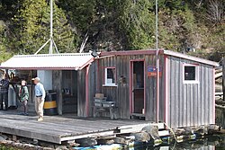
D.M. Arbuthnot was the inaugural postmaster 1912–1912, [22] A general store operated. Numbering around 100 in the late 1910s [23] (possibly an overestimate), permanent residents reduced to 50 during the 1920s and 1930s. [24] However, the seasonal cannery workers boosted the total population to about 300 during this whole period. The 1946 cannery closure shrank these numbers, reducing further on the 1960 reduction plant closure. By this time, the store had become a shadow of its former self, [25] closing a few years later. By 1967, only two families remained as permanent residents at the cannery location. [26] The former manager's house later became the Kildonan Lodge. Nowadays, the ferry drops off and collects mail three times weekly at the floating post office. [3] The post office hours are limited to two days a week. [27]

Transportation

By the late 1910s, Kildonan was a port of call on the three times monthly VictoriaPort Alice Canadian Pacific Railway (CP) coastal steamboat run, [28] which remained largely unchanged until the early 1950s. [29] From the 1930s, the summer schedule was every 5 days. [30] [31] During the 1950s, the terminal moved south to Chamiss Bay. [32] In July 1958, CP withdrew the west coast route. [33]

From the 1910s, a three-times weekly launch also operated from Port Alberni. [34] In 1946, the Barkley Sound Transportation Co. was formed. The three-times weekly run was Port Alberni–Franklin River–Kildonan–Bamfield–south shore of Barkley Sound–Port Alberni. [35] In 1955, the company replaced the MV Unchuck I with the MV Unchuck II on the Kildonan–Sarita–Bamfield run. [36] From 1959, the government subsidized this essential service. [37]

Nowadays, Lady Rose Marine Services operates the three times weekly Port Alberni–Kildonan–Bamfield–Port Alberni run. [38] The MV Frances Barkley and MV Lady Rose sail this passenger/mail/freight route, which also stops at intermediate float homes to make pickups and deliveries. [39]

See also

Footnotes

  1. "Kildonan (locality)". BC Geographical Names .
  2. 1 2 Paterson & Basque 1999, p. 96.
  3. 1 2 3 4 5 6 "Alberni Inlet – Kildonan". www.katherinebickford.ca.
  4. White 1999, p. 114 (104).
  5. 1 2 3 4 "Kildonan Cannery". www.tidestotins.ca.
  6. "Prince Rupert Optimist, 20 Jan 1911". www.library.ubc.ca. p. 6.
  7. 1 2 The Development of the Pacific Salmon-Canning Industry , p. 223, at Google Books
  8. White 1999, p. 119 (109).
  9. Higginbottom 1988, p. 139 (124).
  10. Paterson & Basque 1999, pp. 96–97.
  11. 1 2 The Development of the Pacific Salmon-Canning Industry , p. 224, at Google Books
  12. Higginbottom 1988, p. 150 (135).
  13. 1 2 3 Paterson & Basque 1999, p. 97.
  14. Higginbottom 1988, pp. 150–151 (135–136).
  15. Higginbottom 1988, p. 153 (138).
  16. White 1999, p. 112 (122).
  17. Muszynski, Alicja (1986). "The Creation and Organization of Cheap Labour in the BC Fishing Industry". www.library.ubc.ca. p. 227 (220).
  18. "Thunderbird's Nest (T'iitsk'in Paawats) Protected Area Management Plan" (PDF). www.bcparks.ca. p. 8.
  19. "Canada's Earthquakes: 'The Good, the Bad, and the Ugly'". www.lib.unb.ca. p. para. 47.
  20. 1 2 "Daily Colonist, 31 Jul 1966". www.archive.org. p. 3.
  21. "Sailing Directions: Discovery Passage to Queen Charlotte Strait and West Coast of Vancouver Island" (PDF). www.charts.gc.ca. p. item 131.
  22. "Postmasters". www.bac-lac.gc.ca.
  23. "1918 BC Directory". www.bccd.vpl.ca.
    to "1920 BC Directory". www.bccd.vpl.ca.
  24. "1921 BC Directory". www.bccd.vpl.ca.
    to "1938 BC Directory". www.bccd.vpl.ca.
  25. "Daily Colonist, 19 Jun 1960". www.archive.org. p. 11.
  26. "Peninsula Times, 15 Mar 1967". www.library.ubc.ca. p. 5.
  27. "Canada Post Kildonan Opening Hours". www.storelocate.ca/canada-post.
  28. "1917 CP timetable". www.library.ubc.ca. p. 2.
  29. "1951 CP timetable". www.library.ubc.ca. p. 2.
  30. "1932 CP timetable". www.library.ubc.ca. p. 2.
  31. "1941 CP timetable". www.library.ubc.ca. p. 28.
  32. "1955 CP timetable". www.library.ubc.ca. p. 50 (Table 152).
  33. "Daily Colonist, 25 Apr 1971". www.archive.org. p. 7.
  34. "1918 BC Directory". www.bccd.vpl.ca.
    to "1955 BC Directory". www.bccd.vpl.ca.
  35. "Nootka Sounder, Jun 2016–Jun 2017" (PDF). www.haversdesign.com.
  36. "Daily Colonist, 7 Jul 1955". www.archive.org. p. 12.
  37. "Daily Colonist, 30 Oct 1959". www.archive.org. p. 40.
  38. "Lady Rose Marine Services: Schedules/Rates". www.ladyrosemarine.com.
  39. "BC Ferry: Port Alberni/Bamfield/Ucluelet". www.vancouverisland.com.

Related Research Articles

<span class="mw-page-title-main">Rogers Pass (British Columbia)</span> Mountain pass in Canada

Rogers Pass is a high mountain pass through the Selkirk Mountains of British Columbia, but the term also includes the approaches used by the Canadian Pacific Railway (CP) and the Trans-Canada Highway. In the heart of Glacier National Park, this National Historic Site has been a tourist destination since 1886.

Eholt is in the Boundary Country region of south central British Columbia. This ghost town, on BC Highway 3, is by road about 27 kilometres (17 mi) northwest of Grand Forks and 14 kilometres (9 mi) northeast of Greenwood.

<span class="mw-page-title-main">Holberg, British Columbia</span> Place in British Columbia, Canada

Holberg is a former ferry terminal about 35 kilometres (22 mi) from the northwest tip of Vancouver Island, British Columbia. This unincorporated community is at the head of Holberg Inlet, which forms the western arm of Quatsino Sound.

<span class="mw-page-title-main">Midway, British Columbia</span> Village in British Columbia, Canada

Midway is in the West Kootenay region of south central British Columbia. The village lies 13 kilometres (8 mi) west of Greenwood and 51 kilometres (32 mi) east of Osoyoos along Highway 3.

Donald is an unincorporated community in the East Kootenay region of southeastern British Columbia. This almost ghost town is on the northeast shore of the Columbia River immediately southeast of the mouth of Marl Creek. The locality, on BC Highway 1, is by road about 28 kilometres (17 mi) northwest of Golden and 122 kilometres (76 mi) northeast of Revelstoke.

<span class="mw-page-title-main">Brookmere</span> Locality in British Columbia, Canada

Brookmere is an unincorporated community adjacent to Brook Creek in the Nicola region of southern British Columbia, in Canada. The former railway town, on Coldwater Rd, is by road about 44 kilometres (27 mi) south of Merritt.

<span class="mw-page-title-main">Glacier, British Columbia</span> Settlement in British Columbia, Canada

Glacier, which once comprised small communities, is on the western approach to Rogers Pass in southeastern British Columbia. The name derives from the Great Glacier, which in the 1880s was just over a mile from the original train station.

<span class="mw-page-title-main">Albert Canyon</span> Railway point in British Columbia, Canada

Albert Canyon is a railway point in the West Kootenay region of southeastern British Columbia. The community was immediately east of the mouth of Albert Creek on the south shore of the Illecillewaet River. That settlement no longer exists, but the Canyon Hot Springs Resort borders to its north. On BC Highway 1, the locality is by road about 33 kilometres (21 mi) northeast of Revelstoke and 30 kilometres (19 mi) southwest of Glacier.

Palliser is a railway point which straddles the shores of the Kicking Horse River in the East Kootenay region of southeastern British Columbia. This ghost town, off BC Highway 1, is by road about 36 kilometres (22 mi) southwest of Field and 21 kilometres (13 mi) southeast of Golden.

Keefers is a railway point in the lower Fraser Canyon area of southwestern British Columbia. The ghost town is on the west shore of the Fraser River and north of the mouth of the Nahatlatch River. The locality is by rail about 82 kilometres (50.8 mi) north of Hope and 26 kilometres (15.9 mi) south of Lytton.

Thrums is an unincorporated community on the northwest shore of the Kootenay River in the West Kootenay region of southeastern British Columbia. The location, on BC Highway 3A, is by road about 11 kilometres (7 mi) northeast of Castlegar, and 33 kilometres (21 mi) southwest of Nelson.

Vallican is an unincorporated community on the west side of the Slocan River in the West Kootenay region of southeastern British Columbia. At the mouth of the Little Slocan River, the locality formerly spanned both sides of the Slocan River. The rural neighbourhood is off BC Highway 6 about 30 kilometres (19 mi) south of Slocan, and 39 kilometres (24 mi) north of Castlegar.

Niagara is on the west side of the Granby River, near the junction with Fisherman Creek, in the Boundary Country region of south central British Columbia. The small community is about 12 kilometres (7 mi) north of Grand Forks on North Fork Rd.

Paulson is a ghost town in the Boundary Country region of south central British Columbia. The locality, on the Paulson Detour Rd off Highway 3, is about 26 kilometres (16 mi) northeast of Christina Lake and 54 kilometres (34 mi) west of Castlegar.

Shushartie is a ghost town on the east shore of Shushartie Bay near the northeastern extremity of Vancouver Island, British Columbia.

<span class="mw-page-title-main">Parson, British Columbia</span> Place in British Columbia, Canada

Parson is an unincorporated community on the east shore of the Columbia River, in the Columbia Valley region of southeastern British Columbia. The locality, on BC Highway 95, is by road about 212 kilometres (132 mi) north of Cranbrook and 35 kilometres (22 mi) southeast of Golden.

Harry Bruce Johnston was a Canadian politician, who served in the Legislative Assembly of British Columbia.

Zamora is on the west side of the Kettle River in the Boundary region of south central British Columbia. The rural settlement, on BC Highway 33, is by road about 12 kilometres (7 mi) north of Rock Creek and 124 kilometres (77 mi) southeast of Kelowna.

Beavermouth is about 43 kilometres (27 mi) west of Golden, and about 32 kilometres (20 mi) east of the mid-point of the Connaught Tunnel beneath Rogers Pass, in southeastern British Columbia. At the mouth of the Beaver River, the train station was called Beavermouth, but the adjacent community, which no longer exists, was known as Beaver or Beaver Mouth. Nowadays, the closest road access is to the nearby Kinbasket Lake Resort.

Redgrave siding is about 35 kilometres (22 mi) west of Golden, and about 40 kilometres (25 mi) east of the mid-point of the Connaught Tunnel beneath Rogers Pass, in southeastern British Columbia. Accessible by road in the summer months, the former small railway community is long gone. The highway turnoff is at the Redgrave Rest Area.

References

49°00′00″N125°00′00″W / 49.00000°N 125.00000°W / 49.00000; -125.00000 (Kildonana)