Bamfield

Last updated

Bamfield
Bamfield from BMSC 4.jpg
Bamfield, including the Coast Guard Station, as seen from Bamfield Marine Sciences Centre.
Canada Vancouver Island location map.svg
Red pog.svg
Bamfield
Location of Bamfield in British Columbia
Canada British Columbia location map 2.svg
Red pog.svg
Bamfield
Bamfield (British Columbia)
Coordinates: 48°49′49″N125°8′15″W / 48.83028°N 125.13750°W / 48.83028; -125.13750
CountryFlag of Canada (Pantone).svg  Canada
Province Flag of British Columbia.svg  British Columbia
Population
 (2016)
  Total179

Bamfield is a community that is surrounded by Crown Land, First Nation Lands belonging to the Huu-ay-aht Nations, and portions of the Pacific Rim National Park, located on Barkley Sound, Vancouver Island in British Columbia. The community, with a population of 179 as of 2016, [1] is divided by Bamfield Inlet.

Contents

History

Bamfield was populated by Huu-ay-aht of the Nuu-chah-nulth, the local Indigenous people. Europeans founded a small fishing community sometime in the late 1800s. Most of the Indigenous people now live in the neighbouring village of Anacla about 5 kilometres from Bamfield.

Bamfield was named after the first government agent of the area, William Eddy Banfield. The name "Bamfield" with an "m" is said to have occurred either because of how the Huu-ay-aht had pronounced the agent's name, or it was a mistake made by the postal organization. In 1902, the Bamfield cable station was constructed as the western terminus of a worldwide undersea telegraph cable called the All Red Line by some, as it passed only through countries and territories controlled by the British Empire, which were coloured red on maps of the time. The cable initially went to Fanning Island, a tiny coral atoll in the mid-Pacific, and from there continued to Fiji, New Zealand, and Australia. On May 16, 1915, American newspapers reported that an enemy Demo team had tried to land at Bamfield but was scared off by the military guards. [2]

A second building, made of concrete, was built on the site in 1926 to replace the old wood structure. This building, designated a historic site in 1930, is now used by the Bamfield Marine Sciences Centre. During the early years of World War II, Cable & Wireless' cable station was shelled by an Imperial Japanese Navy submarine from nearby Barkley Sound without any major damage being inflicted, however the Canadian Government arranged for a company of troops to be based there until the end of that conflict.

A Marine and Fisheries lifesaving station on the Pacific coast was established at Bamfield in 1907. [3] It was the first lifesaving station on Canada's Pacific Coast.

In 1953 the cable was extended up the Alberni Inlet to Port Alberni and the local station was closed on June 20, 1959. Following the closure, only the large concrete building, two cable storage tanks and an adjacent building survived, as all the rest were demolished.

Part of Bamfield's boardwalk. Bamfield from Dock.jpg
Part of Bamfield's boardwalk.

In 1968, the National Research Council asked five western Canadian universities (University of British Columbia, University of Victoria, University of Calgary, University of Alberta and Simon Fraser University) to propose the best location for a marine biology station on the Pacific Coast. Although Victoria was the earlier winner, a feasibility study tendered in 1969 recommended Bamfield as the better location. The former cable station property was purchased in 1969 and a formal structure for the management and development of the station was created in 1970 when the five universities ratified a Constitution and joined the Western Canadian Universities Marine Biological Society. In 1971, development began to convert the site into a research station. With most of the physical facilities completed, the Bamfield Marine Sciences Centre began operations by the end of 1972. It became the largest employer in the community since. Commercial fishing was based in Bamfield up to the mid-1980s. Bamfield is now home to several sport fishing lodges, which pursue primarily salmon and halibut. Bamfield is also the northern terminus of the West Coast Trail, a hiking trail built in 1907 along the west coast of Vancouver Island to help survivors of the area's many shipwrecks find their way back to civilization. The trail runs 77 kilometres (48 mi) along extremely rugged terrain.

Today Bamfield is primarily a tourist destination, either for the West Coast Trail, ocean kayaking or sport fishing. The research activities at the Bamfield Marine Sciences Centre attracts hundreds of researchers every year. The Bamfield Marine Sciences Centre also offers credited university courses through its five associated universities. An out reach program, which provides multi-day immersion field trips for school, college and adult learners, also bring thousands of visitors to the community every year.

The town is featured in the first episode of CBC Television's 2015 comedy/reality series Still Standing . [4]

Climate

Bamfield experiences an oceanic climate.

Climate data for Bamfield
MonthJanFebMarAprMayJunJulAugSepOctNovDecYear
Record high °C (°F)18.0
(64.4)
19.4
(66.9)
21.7
(71.1)
25.0
(77.0)
31.5
(88.7)
32.8
(91.0)
31.7
(89.1)
32.0
(89.6)
31.0
(87.8)
27.5
(81.5)
20.0
(68.0)
16.5
(61.7)
32.8
(91.0)
Average high °C (°F)7.8
(46.0)
9.0
(48.2)
10.3
(50.5)
12.0
(53.6)
14.3
(57.7)
16.0
(60.8)
18.1
(64.6)
18.8
(65.8)
18.1
(64.6)
14.1
(57.4)
10.0
(50.0)
7.7
(45.9)
13.0
(55.4)
Daily mean °C (°F)4.8
(40.6)
5.6
(42.1)
6.5
(43.7)
8.1
(46.6)
10.6
(51.1)
12.6
(54.7)
14.4
(57.9)
14.8
(58.6)
13.6
(56.5)
10.2
(50.4)
6.8
(44.2)
4.8
(40.6)
9.4
(48.9)
Average low °C (°F)1.7
(35.1)
2.1
(35.8)
2.6
(36.7)
4.1
(39.4)
6.8
(44.2)
9.1
(48.4)
10.6
(51.1)
10.8
(51.4)
9.1
(48.4)
6.3
(43.3)
3.5
(38.3)
1.8
(35.2)
5.7
(42.3)
Record low °C (°F)−9.4
(15.1)
−9.5
(14.9)
−4.0
(24.8)
−2.2
(28.0)
−0.6
(30.9)
2.2
(36.0)
4.4
(39.9)
4.0
(39.2)
0.0
(32.0)
−3.5
(25.7)
−9.0
(15.8)
−10.6
(12.9)
−10.6
(12.9)
Average precipitation mm (inches)387.7
(15.26)
344.0
(13.54)
321.7
(12.67)
205.1
(8.07)
144.8
(5.70)
105.5
(4.15)
61.2
(2.41)
75.1
(2.96)
102.9
(4.05)
290.6
(11.44)
443.4
(17.46)
407.3
(16.04)
2,889.2
(113.75)
Average rainfall mm (inches)381.6
(15.02)
339.5
(13.37)
320.0
(12.60)
205.0
(8.07)
144.8
(5.70)
105.5
(4.15)
61.2
(2.41)
75.1
(2.96)
102.9
(4.05)
290.6
(11.44)
441.2
(17.37)
402.1
(15.83)
2,869.4
(112.97)
Average snowfall cm (inches)6.1
(2.4)
4.5
(1.8)
1.8
(0.7)
0
(0)
0
(0)
0
(0)
0
(0)
0
(0)
0
(0)
0.1
(0.0)
2.3
(0.9)
5.1
(2.0)
19.9
(7.8)
Average precipitation days (≥ 0.2 mm)21.019.220.518.114.211.98.07.810.317.522.321.7192.5
Average rainy days (≥ 0.2 mm)20.418.920.418.114.211.98.07.810.317.522.121.0190.7
Average snowy days (≥ 0.2 cm)1.51.20.780.04000000.040.501.75.7
Source: Environment Canada [5]

Related Research Articles

<span class="mw-page-title-main">Pacific Rim National Park Reserve</span> National park reserve in British Columbia, Canada

Pacific Rim National Park Reserve is a 511 km2 (197 sq mi) national park located in British Columbia, Canada, which comprises three separate regions: Long Beach, the Broken Group Islands, and the West Coast Trail. Its the Pacific Coast Mountains, are characterized by rugged coasts and temperate rainforests.

<span class="mw-page-title-main">Port Alberni</span> City in British Columbia, Canada

Port Alberni is a city located on Vancouver Island in the province of British Columbia, Canada. The city lies within the Alberni Valley at the head of the Alberni Inlet, Vancouver Island's longest inlet. It is the location of the head offices of the Alberni-Clayoquot Regional District. Port Alberni currently has a total population of 18,259.

<span class="mw-page-title-main">Bamfield Marine Sciences Centre</span>

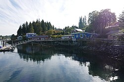
Bamfield Marine Sciences Centre is a marine research station established in 1972, located in Bamfield, Barkley Sound, British Columbia and run by the University of Victoria, the University of British Columbia, Simon Fraser University, the University of Alberta, and the University of Calgary. The Centre hosts numerous public education programs in marine related science. BC Field Trips organizes many instructional and educational programs for school-aged children at the Centre. The Centre also runs courses for university students during the summer and during the fall through their affiliated universities.

<span class="mw-page-title-main">Ucluelet</span> District municipality on the west coast of Vancouver Island

Ucluelet is a district municipality on the Ucluelet Peninsula, on the west coast of Vancouver Island in British Columbia, Canada. Ucluelet comes from Yuułuʔił which means "people of the safe harbour" in the indigenous Nuu-chah-nulth language and is the homeland of the Yuułuʔiłʔatḥ. As of 2021, its population was 2,066, a 20.3% increase from 1,717 in 2016.

<span class="mw-page-title-main">Cape Beale Light</span> Lighthouse

Cape Beale Lightstation is an active manned lighthouse on Vancouver Island in British Columbia., Canada.

<span class="mw-page-title-main">West Coast Trail</span> Backpacking trail in British Columbia, Canada

The West Coast Trail, originally called the Dominion Lifesaving Trail, is a 75 km (47 mi) backpacking trail following the southwestern edge of Vancouver Island in British Columbia, Canada. It was built in 1907 to facilitate the rescue of shipwrecked survivors along the coast, part of the treacherous Graveyard of the Pacific. It is now part of the Pacific Rim National Park and is often rated by hiking guides as one of the world's top hiking trails.

<span class="mw-page-title-main">Canadian Coast Guard Auxiliary</span>

The Canadian Coast Guard Auxiliary is a Canada-wide volunteer marine association dedicated to marine search and rescue (SAR) and the promotion of boating safety, through association with the Canadian Coast Guard under the auspices of Canada's National Search and Rescue Program.

<span class="mw-page-title-main">Port Renfrew</span> Unincorporated community on Vancouver Island in British Columbia, Canada

Port Renfrew is a small unincorporated community located on the south shore of Port San Juan, an inlet on the west coast of Vancouver Island in British Columbia, Canada. Port Renfrew has a population of 262 and has been touted as "the Tall Tree Capital of Canada".

The NEPTUNE Ocean Observatory project is part of Ocean Networks Canada which is a University of Victoria initiative. NEPTUNE is the world's first regional-scale underwater ocean observatory that plugs directly into the Internet. NEPTUNE is the largest installation on the Ocean Networks Canada network of ocean observatories. Since December 2009, it has allowed people to "surf" the seafloor while ocean scientists run deep-water experiments from labs and universities around the world. Along with its sister project, VENUS, NEPTUNE offers a unique approach to ocean science. Traditionally, ocean scientists have relied on infrequent ship cruises or space-based satellites to carry out their research, while the NEPTUNE project uses a remotely operated crawler.

<span class="mw-page-title-main">Hupacasath First Nation</span> Place in British Columbia, Canada

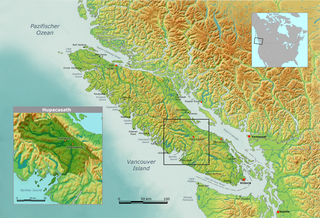
The Hupacasath First Nation is a First Nations government based in the Alberni Valley on the west coast of Vancouver Island in British Columbia, Canada. It is a member of the Nuu-chah-nulth Tribal Council. An alternate spelling of Hupacasath is Opetchesaht or Opitchesaht. Hupacasath First Nation consists of approximately 300 members across five reserves.

<span class="mw-page-title-main">Huu-ay-aht First Nations</span> First Nations band government in British Columbia, Canada

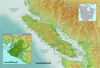
The Huu-ay-aht First Nations is a First Nations band government based on Pachena Bay about 300 km (190 mi) northwest of Victoria, British Columbia on the west coast of Vancouver Island, in Canada. The traditional territories of the Huu-ay-aht make up the watershed of the Sarita River. The Huu-ay-aht is a member of the Nuu-chah-nulth Tribal Council and is a member of the Maa-nulth Treaty Society. It completed and ratified its community constitution and ratified the Maa-nulth Treaty on 28 July 2007. The Legislative Assembly of British Columbia passed the Maa-nulth First Nations Final Agreement Act on Wednesday, 21 November 2007 and celebrated with the member-nations of the Maa-nulth Treaty Society that evening.

<span class="mw-page-title-main">Alberni Inlet</span>

Alberni Inlet is a long, narrow inlet in Vancouver Island, British Columbia, Canada, that stretches from the Pacific Ocean at Barkley Sound about 40 km (25 mi) inland terminating at Port Alberni. It was named by the Spanish explorer Francisco de Eliza after Pedro de Alberní y Teixidor, Captain of the Free Company of Volunteers of Catalonia who was appointed in the Spanish fort in Nootka Sound from 1790 to 1792. The inlet includes traditional territories of the Ucluelet, Uchucklesaht, Huu-ay-aht, Hupacasath, and Tseshaht peoples, who are part of the Nuu-chah-nulth Tribal Council people.

MV <i>Lady Rose</i>

MV Lady Rose is a small, single-screw, diesel coastal vessel, which operated on the west coast of British Columbia, Canada.

<span class="mw-page-title-main">Tofino</span> District municipality in British Columbia, Canada

Tofino is a town of approximately 2,516 residents on the west coast of Vancouver Island in the Canadian province of British Columbia. The District of Tofino is located at the western terminus of Highway 4 on the tip of the Esowista Peninsula at the southern edge of Clayoquot Sound. It is situated in the traditional territory of the Tla-o-qui-aht First Nations.

Ocean Networks Canada is a world-leading research and ocean observing facility hosted and owned by the University of Victoria, and managed by the not-for profit ONC Society. ONC operates unparalleled observatories in the deep ocean and coastal waters of Canada’s three coasts–the Arctic, the Pacific and the Atlantic–gathering biological, chemical, geological and physical data to drive solutions for science, industry and society. ONC operates the NEPTUNE and VENUS cabled ocean observatories in the northeast Pacific Ocean and the Salish Sea. Additionally, Ocean Networks Canada operates smaller community-based observatories offshore from Cambridge Bay, Nunavut., Campbell River, Kitamaat Village and Digby Island. These observatories collect data on physical, chemical, biological, and geological aspects of the ocean over long time periods. As with other ocean observatories such as ESONET, Ocean Observatories Initiative, MACHO and DONET, scientific instruments connected to Ocean Networks Canada are operated remotely and provide continuous streams of freely available data to researchers and the public. Over 200 gigabytes of data are collected every day.

Kildonan is an unincorporated community in the Alberni Inlet-Barkley Sound region of the west coast of southern Vancouver Island, British Columbia. The former steamboat landing and ferry dock is on the east shore of Uchuchklesit Inlet, which branches northwest of the lower reaches of Alberni Inlet. Adjacent to Pacific Rim National Park Reserve, the locality is by road and ferry about 120 kilometres (75 mi) southwest of Port Alberni.

Gord Johns is a Canadian businessman and politician. Since 2015, he has served as the New Democrat Member of Parliament for the federal electoral riding of Courtenay—Alberni in the House of Commons of Canada. He previously served as a town councillor for Tofino, British Columbia, and founded a number of small businesses.

<span class="mw-page-title-main">Anne Salomon</span> Canadian applied marine ecologist

Anne Katherine Salomon is a Canadian applied marine ecologist. She is an associate professor with the School of Resource and Environmental Management in the Faculty of Environment at Simon Fraser University. In 2019, Salomon was elected a Member of the College of New Scholars, Artists, and Scientists of the Royal Society of Canada.

Pachena Bay is located 13 km (8.1 mi) south of Bamfield in Pacific Rim National Park at the southern end of Vancouver Island, British Columbia, Canada. It was the location of a First Nation's village that was destroyed by a tsunami in 1700.

The Sarita River is an approximately 25 km (16 mi)-long river on the west coast of Vancouver Island, British Columbia, Canada, just north of the hamlet of Bamfield.

References

  1. Population of Bamfield. 2016 Census data.
  2. The Daily Gate City, May 16, 1915, p. 1.
  3. Thomas E. Appleton (March 31, 2008). "USQUE AD MARE: A History of the Canadian Coast Guard and Marine Services". Canadian Coast Guard. Archived from the original on July 26, 2011.
  4. "Murdoch Mysteries’ Jonny Harris hosts new show Still Standing". canada.com, June 22, 2015.
  5. Environment CanadaCanadian Climate Normals 1971–2000, Retrieved 23 August 2012