Parksville, British Columbia

Last updated

Parksville
City of Parksville
Beach Side Seawall, Parksville, Vancouver Island (36676401172).jpg
Nickname: 
Jewel of Vancouver Island
CountryCanada
Province British Columbia
Regional district Nanaimo
IncorporatedJune 19, 1945
Town statusMarch 30, 1978
City statusFebruary 15, 1986
Electoral districts     
Federal

Courtenay—Alberni
Provincial Parksville-Qualicum
Government
  TypeMayor-council government
  BodyMunicipal council
  MayorDoug O'Brien
Area
   City 14.56 km2 (5.62 sq mi)
  Metro
81.86 km2 (31.61 sq mi)
Population
 (2021)
   City 13,642
  Density939.5/km2 (2,433/sq mi)
   Metro
28,922
  Metro density353.3/km2 (915/sq mi)
Time zone UTC-8 (Pacific Standard Time)
  Summer (DST) UTC-7 (Pacific Daylight Time)
Forward Sortation Code
V9P
Area code(s) 250, 778, 236, 672
Website www.parksville.ca OOjs UI icon edit-ltr-progressive.svg

Parksville is a city on Vancouver Island in British Columbia, Canada. As of the 2021 Census, Parksville's population was 13,642, representing a 9.5% increase over the 2016 Census. [1]

Contents

Parksville is well known for its large, sandy beaches at Parksville Bay and Craig Bay. The city's best-known annual event since 1982 is a sandcastle-building competition held from mid-July to mid-August, dubbed "Parksville Beachfest". Beachfest is the only World Championship Sand Sculpting official qualification event in Canada. [2]

Parksville is served by the coast-spanning Island Highway, the Island Rail Corridor, and a nearby airport.

History

Human habitation has occurred in the area for thousands of years. Prior to Euro-Canadian settlement, the area was inhabited by several Coast Salish indigenous groups: Qualicum, Snaw-naw-as (Nanoose), and Snuneymuxw peoples.

The Spanish were the first Europeans to explore the area in 1791, followed shortly by the fleet of George Vancouver of the British Royal Navy. On Spanish maps, the Englishman River was called 'Rio de Grullas,' (River of Cranes, i.e. herons) at the site of modern-day San Pareil, while French Creek was named 'Punta de Leonardo.'

The first European landholder in the Parksville area was John Hirst, who pre-empted 120 hectares (300 acres) of land on both sides of the Englishman River in 1873, although he never relocated there from Nanaimo. [3] The River, as it was known, remained an outpost until the turn of the 20th century when a road was built from Nanaimo.

A post office soon followed in 1877, with mail distributed from the cabin of the first postmaster, Nelson Parks, for whom the city is named. [4] :202

At that time, logging was a major industry and the extension of the Esquimalt and Nanaimo (E & N) Railway in 1901, to McBride Junction spurred Parksville's growth and the beginning of a tourism boom, mainly Vancouver Islanders who travelled to Parksville to enjoy the incredible beaches.

Motels, stores, resorts and campgrounds soon followed and the community continues to prosper today. The Village of Parksville was incorporated June 19, 1945. Parksville became a town on April 1, 1978, and a city on June 1, 1981.

Geography

The city lies along Highway 19A, 37 km (23 mi) northwest of Nanaimo, 48 km (30 mi) east of Port Alberni and 7 km (4 mi) kilometres southeast of Qualicum Beach. The majority of Parksville's land base lies between Englishman River and French Creek, although a substantial portion of the city lies east of Englishman River, along the western shores of Craig Bay.

Climate

Parksville has a Csb warm-summer mediterranean climate with July and August having less than 40mm of rain.

Climate data for Parksville
MonthJanFebMarAprMayJunJulAugSepOctNovDecYear
Record high °C (°F)14.4
(57.9)
16.1
(61.0)
18.9
(66.0)
24.0
(75.2)
31.5
(88.7)
30.5
(86.9)
31.1
(88.0)
31.1
(88.0)
32.0
(89.6)
23.5
(74.3)
17.8
(64.0)
16.0
(60.8)
32.0
(89.6)
Average high °C (°F)5.7
(42.3)
7.3
(45.1)
9.5
(49.1)
12.7
(54.9)
16.4
(61.5)
19.1
(66.4)
22.0
(71.6)
21.8
(71.2)
18.4
(65.1)
13.0
(55.4)
8.3
(46.9)
5.8
(42.4)
13.3
(55.9)
Daily mean °C (°F)3.0
(37.4)
4.0
(39.2)
5.6
(42.1)
8.3
(46.9)
11.7
(53.1)
14.5
(58.1)
16.8
(62.2)
16.6
(61.9)
13.4
(56.1)
9.1
(48.4)
5.4
(41.7)
3.3
(37.9)
9.3
(48.7)
Average low °C (°F)0.3
(32.5)
0.8
(33.4)
1.6
(34.9)
3.9
(39.0)
7.0
(44.6)
9.9
(49.8)
11.6
(52.9)
11.3
(52.3)
8.4
(47.1)
5.2
(41.4)
2.4
(36.3)
0.7
(33.3)
5.2
(41.4)
Record low °C (°F)−15.6
(3.9)
−13.0
(8.6)
−9.0
(15.8)
−2.8
(27.0)
0.0
(32.0)
2.8
(37.0)
5.0
(41.0)
4.4
(39.9)
−0.5
(31.1)
−6.0
(21.2)
−14.0
(6.8)
−14.4
(6.1)
−15.6
(3.9)
Average precipitation mm (inches)193.4
(7.61)
163.6
(6.44)
118.1
(4.65)
68.9
(2.71)
50.9
(2.00)
47.3
(1.86)
28.0
(1.10)
36.9
(1.45)
51.7
(2.04)
137.4
(5.41)
218.0
(8.58)
199.9
(7.87)
1,314.2
(51.74)
Source: Environment Canada [5]

Demographics

In the 2021 Census of Population conducted by Statistics Canada, Parksville had a population of 13,642 living in 6,754 of its 7,105 total private dwellings, a change of

The median household income in 2006 for Parksville was $55,524, which is below the British Columbia provincial average of $62,346. [7]

Religion

According to the 2021 census, religious groups in Parksville included: [8]

Economy

Tertiary sector and secondary sector jobs make up the largest part of the Parksville economy. The three largest types of occupations in Parksville are the service industry; the construction industry; and the business, financial, and administration industries. These are the largest sectors of the city's economy largely due to the summer tourism industry, and a large influx of retirees moving into the area. There is also a fair amount of primary sector industry in the surrounding areas of Parksville, primarily fishing and forestry.

There is an industrial park located in the Southeast section of the city, known as the Orange Bridge Business District, which includes many tradesman shops.

Tourism

Parksville has long been a tourist location primarily catering to people from across Vancouver Island as well as Greater Vancouver.

Parksville Beach (located at Community Park) and Rathtrevor Beach are two of the city's main attractions.

Education

The City of Parksville is located within School District 69 Qualicum. Springwood Elementary, Oceanside Elementary and Ballenas Secondary School are all located within Parksville. School District 69 also operates a Continuing Education Centre, Collaborative Education Alternate Program and PASS/Woodwinds Alternate School in Parksville.

A regional campus of Vancouver Island University is located in Parksville.

Culture, recreation, and leisure

Polar Bear Splash

Every year on January 1, residents gather at Parksville Community Park beach to plunge into the cold water to welcome in the new year. [9] [10]

Summer By the Sea Market

Each summer, Parksville holds a night market on Tuesdays. The market draws in visitors and helps to support local small businesses. In the past, the market has had up to 150 vendors. During the COVID-19 pandemic, the market was relocated to the Parksville Community Centre and the number of vendors was reduced. As of 2022, it has returned to Craig Street. [11]

Canada Day Parade

Parksville hosts an annual Canada Day celebration. In the morning there is a parade that runs along the Island Hwy. Residents and visitors gather along the road to watch the procession and then walk down to Parksville Community Park where there are vendors, including food trucks, live music performances, some carnival attractions, and fireworks. [12]

Related Research Articles

<span class="mw-page-title-main">Vancouver Island</span> Southwesternmost Island of Canada

Vancouver Island is an island in the northeastern Pacific Ocean and part of the Canadian province of British Columbia. The island is 456 km (283 mi) in length, 100 km (62 mi) in width at its widest point, and 32,100 km2 (12,400 sq mi) in total area, while 31,285 km2 (12,079 sq mi) are of land. The island is the largest by area and the most populous along the west coasts of the Americas.

<span class="mw-page-title-main">Nanaimo</span> City in British Columbia, Canada

Nanaimo is a city on the east coast of Vancouver Island, in British Columbia, Canada. As of the 2021 census, it had a population of 99,863, and it is known as "The Harbour City." The city was previously known as the "Hub City," which was attributed to its original layout design, whose streets radiated from the shoreline like the spokes of a wagon wheel, and to its central location on Vancouver Island. Nanaimo is the headquarters of the Regional District of Nanaimo.

Highway 19 is the main north-south thoroughfare on Vancouver Island from Nanaimo to Port Hardy. A highway has existed on the Island since about 1912. Originally gravel and rough, the highway was an essential link together with the Esquimalt & Nanaimo Railway. The paved highway first opened in 1953, replacing a stretch of Highway 1 between Nanaimo and Campbell River, finally being extended to the northern tip of the island in the late 1970s. The total length of the highway is 403 kilometres (250 mi).

Highway 19A, known locally as the Oceanside Route or the Old Island Highway, is a provincial highway in British Columbia, Canada. It runs along two former sections of Highway 19 on Vancouver Island, within Nanaimo and between Craig's Crossing and Campbell River. The section of Highway 19A between Craig's Crossing and Campbell River is 136.89 km (85.06 mi) long, and the Nanaimo alignment covers 10.64 km (6.61 mi). The highway was established after Highway 19 was realigned to a new road between 1996 and 2001.

Highway 4 is the longest east–west main vehicle route on Vancouver Island, British Columbia, Canada, with a total length of 162 km (101 mi). It is known locally as the Alberni Highway to the east of Port Alberni and the Pacific Rim Highway to the west. The original highway from Parksville to Alberni and Port Alberni was completed in 1942 and was originally designated as Highway 1A. It was re-designated as Highway 4 in 1953, and was extended in 1961 to the district of Tofino, on the west coast of the Island.

<span class="mw-page-title-main">Island Rail Corridor</span> Railway operation in Vancouver Island

The Island Rail Corridor, previously the Esquimalt & Nanaimo Railway, is a railway operation on Vancouver Island and is the only remaining railway on Vancouver Island after the closure of the Englewood Railway in November 2017. The Island Corridor Foundation owns the former Esquimalt & Nanaimo Railway corridor. The railway line is 225 kilometres (140 mi) in length from Victoria to Courtenay, known as the Victoria Subdivision, with a branch line from Parksville to Port Alberni known as the Port Alberni Subdivision at 64 kilometres (40 mi) in length, for a total 289 kilometres (180 mi) of mainline track. In 2006, the Island Corridor Foundation acquired the railway's ownership from the Canadian Pacific Railway.

<span class="mw-page-title-main">Qualicum Beach</span> Town in British Columbia, Canada

Qualicum Beach is a town located on Vancouver Island, British Columbia, Canada. In the 2021 census, it had a population of 9,303. It is situated at the foot of Mount Arrowsmith, along the Strait of Georgia on Vancouver Island's northeastern coast.

<span class="mw-page-title-main">Vancouver Island University</span> Canadian public university

Vancouver Island University is a Canadian public university serving Vancouver Island and coastal British Columbia. Malaspina College began in 1969 and it has grown into a university which plays an important role in the educational, cultural, and economic life of the region. The main campus is located in Nanaimo; there are regional campuses in Duncan and Powell River as well as a centre in Parksville.

<span class="mw-page-title-main">Regional District of Nanaimo</span> Regional district in British Columbia, Canada

The Regional District of Nanaimo is a regional district located on the eastern coast of Vancouver Island, British Columbia, Canada. It is bordered to the south by the Cowichan Valley Regional District, to the west by the Alberni-Clayoquot Regional District, and to the northwest by the Comox Valley Regional District. Its administration offices are located in Nanaimo. During the 2016 census, its population was established at 155,698.

Mark Allan Robinson was the proponent of the first recall petition in Canadian history to remove an elected politician that reached the required threshold to force a by-election.

<span class="mw-page-title-main">Lasqueti Island</span>

Lasqueti Island is an island off the east coast of Vancouver Island in the Strait of Georgia, qathet Regional District, British Columbia, Canada and has a population of 498. A passenger-only ferry connects the island to the community of French Creek, near Parksville. The ferry makes two to three runs per day, six days per week, weather permitting. The ferry service is run by Western Pacific Marine for BC Ferries.

<span class="mw-page-title-main">Englishman River Falls Provincial Park</span> Provincial park in Canada

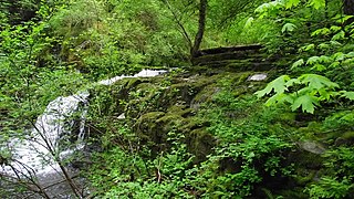
Englishman River Falls Provincial Park is a provincial park in British Columbia, Canada. It is located west of Parksville and borders the small community of Errington on Vancouver Island.

<span class="mw-page-title-main">Bowser, British Columbia</span> Town in British Columbia, Canada

Bowser is a community on the east coast of Vancouver Island in British Columbia, Canada. It has a population of 1,729. Approximately 66 kilometres (41 mi) north of Nanaimo, Bowser is in a region informally known as Lighthouse Country, spanning a stretch of highway that extends from Qualicum Beach in the south to Horne Lake to the west and Fanny Bay in the north and east to Denman and Hornby Islands. Bowser is in the Regional District of Nanaimo and in its Electoral Area H, one of eight in the District. The community was named after William J. Bowser, premier of British Columbia from 1915 to 1916.

<span class="mw-page-title-main">CHPQ-FM</span> Radio station in Parksville, British Columbia

CHPQ-FM is a Canadian radio station operating in Parksville, British Columbia at 99.9 FM. Island Radio, a division of the Jim Pattison Group, owns the station.

<span class="mw-page-title-main">Errington, British Columbia</span>

Errington is a small community on Vancouver Island, British Columbia, Canada, located on Errington Road, off Highway 4, just south of Parksville and Qualicum Beach.

<span class="mw-page-title-main">Scott Fraser (politician)</span> Canadian politician

Scott Kenneth Fraser is a Canadian politician who represented the Mid Island-Pacific Rim electoral district Legislative Assembly of British Columbia from 2005 to 2020. He is a member of the British Columbia New Democratic Party and was first elected as a Member of the Legislative Assembly in the 2005 election and re-elected in the 2009, 2013 and 2017 elections. During the 41st Parliament (2017-2020) he served in the Executive Council as the Minister of Indigenous Relations and Reconciliation. In that role he led the government through adopting the Declaration on the Rights of Indigenous Peoples Act, with all party support, to implement UNDRIP

Oceanside is a name adopted for a group of communities on the eastern coast of Vancouver Island in British Columbia, Canada. It is part of the Regional District of Nanaimo and includes the City of Parksville and the Town of Qualicum Beach as well as the unincorporated communities of Nanoose Bay, Coombs, Errington, French Creek, Bowser, Deep Bay, Qualicum Bay and a few other smaller centres. The area is promoted by Parksville Qualicum Beach Tourism Association.

Mount Moriarty is a mountain on Vancouver Island, British Columbia, Canada, located 22 km (14 mi) southwest of Parksville and 14 km (9 mi) southeast of Mount Arrowsmith. It is named after William Moriarty who was first lieutenant on HMS Plumper on this coast from 1857 to 1861. It is a series of low domed summits at the head of the Cameron River, the Nanaimo River and the Englishman River. Labour Day Lake lies to the south-west.

Qualicum-Graham Park or Qualicum is a suburban neighbourhood in College Ward in the City of Ottawa, Ontario, Canada. It is located in the former City of Nepean in the west end of the city. Many of the residences in the area are executive homes situated on large lots (100x100) being built in the 1960s. Qualicum Street boasts large custom houses built by Bill Teron. The neighbourhood is bounded to the north by the Queensway, to the west by Richmond Road, to the south by Baseline Road, and to the east by Morrison Drive at the former Ottawa-Nepean border towards Redwood. Named after Qualicum Beach in British Columbia.

<span class="mw-page-title-main">Mount Arrowsmith Biosphere Region</span> UNESCO Biosphere Reserve in British Columbia, Canada

Mount Arrowsmith Biosphere Region (MABR) is a UNESCO Biosphere Reserve located on the east coast of Vancouver Island in British Columbia, Canada. It was designated in 2000 by UNESCO to protect a large second-growth coast Douglas fir ecosystem in the watersheds of the Little Qualicum and Englishman Rivers from being developed.

References

  1. Government of Canada, Statistics Canada (February 9, 2022). "Profile table, Census Profile, 2021 Census of Population - Parksville, City (CY) [Census subdivision], British Columbia". www12.statcan.gc.ca. Retrieved May 10, 2022.
  2. Parksville Beach Festival Society. "About Us". www.parksvillebeachfest.ca. Retrieved August 6, 2018.
  3. Parksville Museum (2001). "A Chronological History of Parksville" (PDF). Parksville Museum. Retrieved August 6, 2018.
  4. Akrigg, G.P.V.; Akrigg, Helen B. (1986), British Columbia Place Names (3rd, 1997 ed.), Vancouver: UBC Press, ISBN   0-7748-0636-2
  5. Environment CanadaCanadian Climate Normals 1971–2000, accessed July 5, 2012
  6. "Population and dwelling counts: Canada, provinces and territories, and census subdivisions (municipalities), British Columbia". Statistics Canada. February 9, 2022. Retrieved February 20, 2022.
  7. "Parksville, British Columbia".
  8. Government of Canada, Statistics Canada (October 26, 2022). "Census Profile, 2021 Census of Population". www12.statcan.gc.ca. Retrieved November 9, 2022.
  9. "28th Annual RDN Polar Bear Splash | RDN". www.rdn.bc.ca. Retrieved January 3, 2023.
  10. "Hundreds take plunge in Parksville's Polar Bear Splash 2023 - Parksville Qualicum Beach News". www.pqbnews.com. January 1, 2023. Retrieved January 3, 2023.
  11. "Parksville chamber starts planning for return of Summer by the Sea Market on Craig Street - Parksville Qualicum Beach News". www.pqbnews.com. April 17, 2022. Retrieved January 3, 2023.
  12. "Plenty of Canada Day activities for Parksville Qualicum Beach residents - Parksville Qualicum Beach News". www.pqbnews.com. June 30, 2022. Retrieved January 3, 2023.

Coordinates: 49°18′54″N124°18′43″W / 49.315°N 124.312°W / 49.315; -124.312