Rathtrevor Beach Provincial Park

Last updated
Rathtrevor Beach Provincial Park
Rathtrevor Beach Provincial Park.jpg
Rathtrevor Beach Provincial Park
Canada British Columbia location map 2.svg
Red pog.svg
Location Parksville, British Columbia, Canada
Coordinates 49°19′23″N124°16′12″W / 49.323°N 124.270°W / 49.323; -124.270
Area347 ha (860 acres)
Established20 April 1967
Visitors836,211 [2] (in 2017-18)
Governing body BC Parks
Website bcparks.ca/rathtrevor-beach-park/

Rathtrevor Beach Provincial Park is a provincial park in Parksville, British Columbia, Canada. Located at the east end of the town, the 347-hectare park features a two-kilometre long stretch of sandy beach, a stand of old-growth Douglas fir trees and 250 vehicle-accessible and 25 walk-in camping spaces. [3] Popular year-round, the park is easily accessible from Highway 19. The sandy beach is the main attraction. At low tide, it stretches nearly a kilometre out into the Strait of Georgia. [3]

Contents

Wildlife

The park is an important stopover area for migratory birds, notably brant geese, which use the beach as a staging area from March 1 to April 15. [4] Deer, raccoons, minks and squirrels have been seen occupying the park during spring migrations. [5] Furthermore, aquatic animals such as otters use the park. [5]

Origin of the name

Rathtrevor takes its name from the Rath family who homesteaded on the land in the late 19th century. The family eventually established a private campground on the site, adding the "trevor" to give it a more romantic name. In 1967, the campground became a provincial park. [4]

Establishment of the park

Rathtrevor Beach Park has a connection to Wells Gray Provincial Park in central British Columbia, Canada. In the 1960s, Clearwater Timber Products, a major employer in Clearwater, just outside Wells Gray Park, was running out of timber to supply the mill. On October 3, 1963, the Social Credit Government passed an order-in-council which stated the terms of an agreement between the government and Clearwater Timber whereby the government received 47 hectares of Rathtrevor Beach, owned by Clearwater Timber Products, in exchange for timber rights in 137 square km of southwestern Wells Gray Park. The beach property was valued at $186,000, so the approved swap allowed for that value of timber to be removed from Wells Gray Park. However, the stumpage fee was fixed at $1.50 per 100 cubic feet for fir, an extremely low price because the standard rate paid by a logging company to the government was $16.90. [6]

An investigation of the deal in 1964 disclosed that the Rath family actually sold their property to Clearwater Timber Products in 1963 for only $150,000, yet within a month the government appraised the property at $186,000. An editorial in the Victoria Daily Times on March 24, 1964, pointed out that “the amount allocated by the government as the value of bargain-priced timber was equivalent to the highest appraisal made on the Rathtrevor property”. Despite the suspicions raised by this investigation, the government granted an additional 65 square km of timber rights to Clearwater Timber in 1964, so its holdings now extended from north of the Flourmill Volcanoes to Mahood Lake.

On April 1, 1969, Bob Williams (a Member of the Legislative Assembly or M.L.A.) told the Legislature, "It seems questionable that a licence should be granted for the company to run at will through Wells Gray Park at bargain basement prices." Former Kamloops M.L.A., Phil Gaglardi, was accused of using his position as Highways Minister to interfere with the Department of Recreation and Conservation in the land swap and thus secure approval for the deal. Williams summarized the loss to the government by pointing out that 204,000 cubic metres (7.2 million cubic feet) of timber had already been cut, yielding $88,000 in stumpage fees applied to the Rathtrevor purchase. The logging company was nearly halfway through the deal in 1969. Up to that year, the government could have collected a total of $670,613 on stumpage fees, or $l.6 million if the deal had been completed, instead of the $186,000 park site it did acquire. Williams called the arrangement “a glaring example of park mismanagement mixed with outside interference. What we are looking at is between 50 and 60 Stanley Parks. What British Columbia, the public, is being left with is stumps.” [6]

By 1974, two years after the New Democratic Party had formed the government, the arrangement with Clearwater Timber was cancelled and the access road to the Flourmill Volcanoes logging area was permanently closed by demolishing the Mahood River bridge. In the 40 years since, Rathtrevor Beach has become one of British Columbia's most popular provincial campgrounds. [6]

Rathtrevor Beach Nature House

Rathtrevor Beach Nature House is a nature centre located in the park and operated by RLC Enterprize. The centre features natural history displays and offers seasonal environmental education programs for school groups and the general public.

See also

Related Research Articles

<span class="mw-page-title-main">Clearwater, British Columbia</span> District municipality in British Columbia, Canada

Clearwater is a district municipality in the North Thompson River valley in British Columbia, Canada, where the Clearwater River empties into the North Thompson River. It is located 124 km (77 mi) north of Kamloops. The District of Clearwater was established on December 3, 2007, making it one of the newest municipalities in British Columbia. It is near Wells Gray Provincial Park and is surrounded by the Trophy Mountains, Raft Mountain and Dunn Peak.

Kikomun Creek Provincial Park is a provincial park in British Columbia, Canada.

<span class="mw-page-title-main">MacMillan Provincial Park</span> Park in British Columbia, Canada

MacMillan Provincial Park is a 301-hectare (740-acre) provincial park in British Columbia, Canada. Located 25 km (16 mi) west of Qualicum Beach and 16 km (9.9 mi) east of Port Alberni, the park straddles Highway 4 and the Island Rail Corridor in central Vancouver Island. It is nestled on the western shore of Cameron Lake, and protects the delta of the Cameron River. The park is home to a famous, 157-hectare (390-acre) stand of ancient Douglas fir, known as Cathedral Grove, which draws visitors from all over the world. The park provides the only highway-accessible protected old-growth Douglas-fir forest in British Columbia. In 2007 Cathedral Grove made the short list on CBC's competition Seven Wonders of Canada.

<span class="mw-page-title-main">Clearwater River (British Columbia)</span> River in British Columbia, Canada

The Clearwater River is the largest tributary of the North Thompson River, joining it at the community of Clearwater, British Columbia. The Clearwater rises from glaciers in the Cariboo Mountains and flows in a mostly southerly direction for 201 km (125 mi) to the North Thompson. Its entire course, except the last 5 km (3 mi), is within Wells Gray Provincial Park. Its confluence with the North Thompson is protected by North Thompson River Provincial Park.

<span class="mw-page-title-main">Pyramid Mountain (Wells Gray-Clearwater)</span>

Pyramid Mountain is a subglacial mound located on the Murtle Plateau in Wells Gray Provincial Park, east-central British Columbia, Canada.

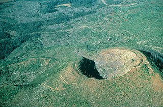
Dragon Cone is a monogenetic cinder cone located in Wells Gray Provincial Park in east-central British Columbia. It is the source of a 15 km (9 mi) long lava flow, called Dragon's Tongue. This lava covered the floor of narrow Falls Creek Valley and terminated at the Clearwater River, damming it to a height of 3 m (10 ft) and raising the level of existing Clearwater Lake upstream. Geologists have recovered some peat buried by the lava and radiocarbon dating produced an age of 7560 years plus or minus 100 years. Flows from nearby Flourmill Cone, Kostal Cone and Spanish Lake Cones rest on glaciated bedrock without an intervening paleosol, suggesting an early Holocene age.

<span class="mw-page-title-main">Kostal Cone</span> Cinder cone in Wells Gray Provincial Park, British Columbia, Canada

Kostal Cone, also called Kostal Volcano and Fire Mountain, is a young cinder cone in Wells Gray Provincial Park in east-central British Columbia, Canada. It rises from the northeast shore of Kostal Lake in the Cariboo Mountains. With an elevation of 1,440 m (4,724 ft), Kostal Cone is one of the lowest volcanoes in the Wells Gray-Clearwater volcanic field.

Buck Hill is a hill in east-central British Columbia, Canada, located 17 km (10.6 mi) north of Clearwater. It rises from the west slope of Trophy Mountain. Buck Hill is just outside the boundary of Wells Gray Provincial Park.

<span class="mw-page-title-main">Flourmill Volcanoes</span>

The Flourmill Volcanoes, also known as The Flourmills, are a small volcano range near the west boundary of Wells Gray Provincial Park in east-central British Columbia, Canada. Located north of Mahood Lake and west of the Clearwater River, they form part of the Wells Gray-Clearwater volcanic field.

<span class="mw-page-title-main">Clearwater Lake (British Columbia)</span>

Clearwater Lake is one of six large lakes in Wells Gray Provincial Park in east-central British Columbia, Canada,. The Clearwater River enters the lake at its north end, flowing from Hobson Lake and Azure Lake, and also drains the lake. There are several small streams that flow into Clearwater Lake, but it has no significant tributaries.

<span class="mw-page-title-main">Spahats Creek Falls</span> Waterfall on Spahats Creek in Wells Gray Provincial Park, British Columbia, Canada

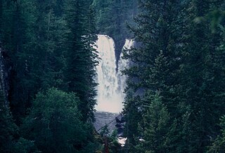
Spahats Creek Falls, also called Spahats Falls, is a waterfall on Spahats Creek within Wells Gray Provincial Park of British Columbia, Canada. Common references place the falls at around 60 m (197 ft) tall, but taking into account the second tier, it is closer to 75–80 meters tall. It is a popular stop for tourists and especially motorcoach tours since it is only 10 km (6.2 mi) off the busy Yellowhead Highway.

<span class="mw-page-title-main">Canim Falls</span>

Canim Falls is a 23 metre high waterfall on the Canim River between Canim Lake and Mahood Lake in Wells Gray Provincial Park in the Cariboo region of the Central Interior of British Columbia, Canada. The waterfall has eroded steadily upstream and created a 4 km (2.5 mi) long canyon cut into a lava plateau associated with the Wells Gray-Clearwater volcanic field.

<span class="mw-page-title-main">Mahood Falls</span> Waterfall on the Canim River in British Columbia, Canada

Mahood Falls is a waterfall in Wells Gray Provincial Park located on the Canim River between Canim Lake and Mahood Lake and northeast of 100 Mile House, British Columbia, Canada. The waterfall is 20 m (66 ft) high.

<span class="mw-page-title-main">Mahood Lake</span> Lake in British Columbia, Canada

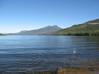
Mahood Lake is a lake in the South Cariboo region of the Interior of British Columbia in Wells Gray Provincial Park. It is drained by the Mahood River, a tributary of the Clearwater River which has cut a deep canyon into Cambrian rocks and Pleistocene glacial moraines. Mahood Lake is fed by the short Canim River, which drains nearby Canim Lake to the west via Canim Falls and Mahood Falls.

<span class="mw-page-title-main">Dawson Falls</span> Waterfall on Clearwater River in Wells Gray Provincial Park, British Columbia, Canada

Dawson Falls is one of seven waterfalls on the Murtle River in Wells Gray Provincial Park, British Columbia, Canada.

<span class="mw-page-title-main">Mahood River</span>

The Mahood River is a river in the northern Shuswap Highland of the Central Interior of British Columbia in Wells Gray Provincial Park. It is 7 kilometres (4.3 mi) long from its source at Mahood Lake to its confluence with the Clearwater River, a tributary of the North Thompson River. The Mahood River has cut a deep canyon into Cambrian rocks and Pleistocene glacial moraines.

<span class="mw-page-title-main">Azure Lake</span> Lake in British Columbia, Canada

Azure Lake is a fjord-like lake located in east-central British Columbia, Canada. It is an expansion of the Azure River which rises from an unnamed glacier in the Cariboo Mountains. The outflow is also called the Azure River, but it is only 50 m (164 ft) long before it flows into the Clearwater River. Azure Lake is one of the six major lakes in Wells Gray Provincial Park.

Murtle Lake is a lava dammed lake located in Wells Gray Provincial Park, east-central British Columbia, Canada. It is fed primarily by the Murtle River which rises from a large unnamed glacier in the Cariboo Mountains at an elevation of 2,300 m (7,546 ft) and flows southwest for 18 km (11 mi) to the lake. The Murtle River also drains Murtle Lake then flows southwest for 36 km (22 mi) into the Clearwater River.

<span class="mw-page-title-main">Wells Gray Provincial Park</span> Provincial park in British Columbia, Canada

Wells Gray Provincial Park is a large wilderness park located in east-central British Columbia, Canada. The park protects most of the southern, and highest, regions of the Cariboo Mountains and covers 5,415 square kilometres. It is British Columbia's fifth largest provincial park, after Tweedsmuir, Tatshenshini, Spatsizi and Northern Rocky Mountains.

<span class="mw-page-title-main">Wells Gray</span> Canadian politician

Arthur Wellesley Gray was a British Columbia cabinet minister and mayor. He is particularly noted for his work creating some of British Columbia's early provincial parks and Wells Gray Provincial Park is named for him. His colleagues usually called him by his nickname, "Wells".

References

  1. "Protected Planet | Rathtrevor Beach Park". Protected Planet. Retrieved 2020-10-13.
  2. "BC Parks 2017/18 Statistics Report" (PDF). bcparks.ca. 2018. Retrieved 2020-10-13.
  3. 1 2 "Rathtrevor Beach Provincial Park - BC Parks".
  4. 1 2 "Rathtrevor Beach Provincial Park - BC Parks".
  5. 1 2 Environment, Ministry of. "Rathtrevor Beach Provincial Park - BC Parks". bcparks.ca. Retrieved 2022-12-01.
  6. 1 2 3 Neave, Roland (2015). Exploring Wells Gray Park, 6th edition. Wells Gray Tours, Kamloops, BC. ISBN   978-0-9681932-2-8.