Regional District of Nanaimo

Last updated

Nanaimo
Regional District of Nanaimo
View of Nanaimo Harbor showing the bastion and shipping (HS85-10-18676).jpg
Nanaimo Bastion
Nanaimo RD BC logo.png
CAN BC Regional District of Nanaimo locator.svg
Location in British Columbia
CountryCanada
Province British Columbia
Administrative office location Nanaimo
Government
[1]
  TypeRegional district
  BodyBoard of directors
  ChairVanessa Craig (B)
  Vice chairTyler Brown (Nanaimo)
  Electoral areas
  • A
  • B
  • C
  • E
  • F
  • G
  • H
Area
  Land2,038.04 km2 (786.89 sq mi)
Population
 (2016) [2]
  Total155,698
  Density76.4/km2 (198/sq mi)
Website www.rdn.bc.ca OOjs UI icon edit-ltr-progressive.svg

The Regional District of Nanaimo is a regional district located on the eastern coast of Vancouver Island, British Columbia, Canada. [3] It is bordered to the south by the Cowichan Valley Regional District, to the west by the Alberni-Clayoquot Regional District, and to the northwest by the Comox Valley Regional District. Its administration offices are located in Nanaimo. During the 2016 census, its population was established at 155,698.

Contents

The Regional District of Nanaimo was incorporated on August 24, 1967. It has members that are cities, towns, districts, and seven electoral areas that contain unincorporated communities.

The region owns and operates the Nanaimo Regional Transit System, which provides conventional local bus routes and special needs paratransit services.

Incorporated municipalities

MunicipalityGovernment TypePopulation
Nanaimo city90,504
Parksville city12,514
Qualicum Beach town8,687
Lantzville district municipality3,601

Electoral areas

Electoral areas have no administrative or governmental function, and are used only to select rural representatives to the Regional District board.

Area A (Cassidy/Cedar/South Wellington)

This electoral area is located on Vancouver Island, on the Stuart Channel southeast of Nanaimo. Jessica Stanley is the elected RDN Director for the electoral area.

According to the Canada 2021 Census:

Contains the communities of Cassidy, Cedar, and South Wellington. Nanaimo Airport is also located here.

Area B (Gabriola Island)

This electoral area contains DeCourcy Island, Gabriola Island and Mudge Island. Vanessa Craig is the elected RDN Director for the electoral area.

According to the Canada 2016 Census:

Area C (Arrowsmith/Benson)

This electoral area is located on Vancouver Island, to the southwest of Nanaimo. It contains the upper Nanaimo River, the Nanaimo Lakes, Mount Benson and Mount Arrowsmith. Lauren Melanson is the elected RDN Director for the electoral area.

According to the Canada 2016 Census:

Contains the community of Extension.

Area E (Nanoose Bay)

This electoral area is located on Vancouver Island, on the shore of the Strait of Georgia, between Lantzville and Parksville. It is co-extensive with the community of Nanoose Bay. Bob Rogers is the elected RDN Director for the electoral area.

According to the Canada 2016 Census:

Area F (Alberni Highway)

This electoral area is located on Vancouver Island, to the west of Qualicum Beach and Parksville. British Columbia Highway 4 runs the length of the area. Leanne Salter is the elected RDN Director for the electoral area.

According to the Canada 2016 Census:

Includes the communities of Coombs, Errington, Hilliers, Meadowood and Whiskey Creek, as well as Cameron Lake and Cathedral Grove.

Area G (Mid-Oceanside)

This electoral area is located on Vancouver Island, on the shore of the Strait of Georgia, surrounding Qualicum Beach and almost surrounding Parksville. Lehann Wallace is the elected RDN Director for the electoral area.

According to the Canada 2016 Census:

Contains the communities of Dashwood and French Creek.

Area H (Lighthouse Country)

This electoral area is located on Vancouver Island, on the shore of the Strait of Georgia at the southern entrance to Baynes Sound, northwest of Qualicum Beach. Stuart McLean is the elected RDN Director for the electoral area.

According to the Canada 2016 Census:

Contains the communities of Bowser, Deep Bay, Dunsmuir and Horne Lake, as well as the Shaw Hill area in its southeastern part.

Demographics

As a census division in the 2021 Census of Population conducted by Statistics Canada, the Regional District of Nanaimo had a population of 170,367 living in 75,273 of its 80,056 total private dwellings, a change of

Panethnic groups in the Nanaimo Regional District (2001−2021)
Panethnic
group
2021 [5] 2016 [6] 2011 [7] 2006 [8] 2001 [9]
Pop. %Pop.%Pop.%Pop.%Pop.%
European [lower-alpha 1] 138,015130,140126,620122,405114,310
Indigenous 12,21010,6358,3906,8155,375
East Asian [lower-alpha 2] 5,0803,8852,8053,1402,070
Southeast Asian [lower-alpha 3] 3,4752,2751,4401,4151,520
South Asian 3,4502,2551,9402,0901,410
African 1,410950600480325
Latin American 925565465260260
Middle Eastern [lower-alpha 4] 775465270150105
Other [lower-alpha 5] 830445435395180
Total responses166,165151,630142,955137,150125,550
Total population170,367155,698146,574138,631127,016

Administrative role

The Regional District of Nanaimo categorizes its responsibilities into five "action areas": [10]

See also

Related Research Articles

<span class="mw-page-title-main">Alberni-Clayoquot Regional District</span> Regional district in British Columbia, Canada

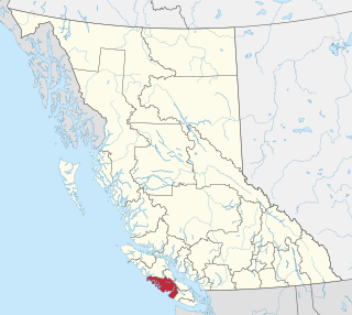
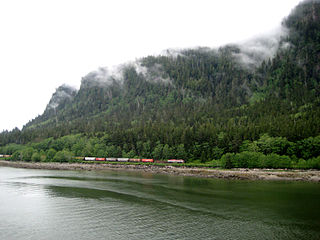
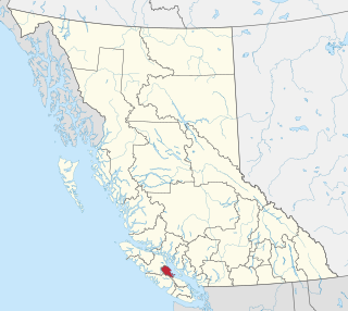
The Alberni–Clayoquot Regional District of British Columbia is located on west central Vancouver Island. Adjacent regional districts it shares borders with are the Strathcona and Comox Valley Regional Districts to the north, and the Nanaimo and Cowichan Valley Regional Districts to the east. The regional district offices are located in Port Alberni.

<span class="mw-page-title-main">Parksville, British Columbia</span> City in British Columbia, Canada

Parksville is a city on Vancouver Island in British Columbia, Canada. As of the 2021 Census, Parksville's population was 13,642, representing a 9.5% increase over the 2016 Census.

<span class="mw-page-title-main">Regional District of Kootenay Boundary</span> Regional district in British Columbia, Canada

The Regional District of Kootenay Boundary (RDKB) is one of 28 regional districts in the province of British Columbia, Canada. As of the 2016 Canadian census, the population was 31,447. The area is 8,095.62 km2. The RDKB was incorporated in 1966 and consists of eight incorporated municipalities and five unincorporated electoral areas. The regional district's offices are in the City of Trail, with secondary offices in the City of Grand Forks. Other major population centres include the cities of Rossland and Greenwood, and the villages of Fruitvale, Warfield, and Montrose. The region also encompasses electoral areas A, B/Lower Columbia-Old Glory, C/Christina Lake, D/Rural Grand Forks and E/West Boundary including Rock Creek, Bridesville, Beaverdell and Big White Ski Resort.

<span class="mw-page-title-main">Ladysmith, British Columbia</span> Town in British Columbia, Canada

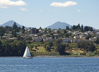
Ladysmith, originally Oyster Harbour, is a town located on the 49th parallel north on the east coast of Vancouver Island, British Columbia, Canada. The local economy is based on forestry, tourism, and agriculture. A hillside location adjacent to a sheltered harbour forms the natural geography of the community.

<span class="mw-page-title-main">Capital Regional District</span> Regional district in British Columbia, Canada

The Capital Regional District (CRD) is a local government administrative district encompassing the southern tip of Vancouver Island and the southern Gulf Islands in the Canadian province of British Columbia. The CRD is one of several regional districts in British Columbia and had an official population of 415,451 as of the Canada 2021 Census.

<span class="mw-page-title-main">Squamish-Lillooet Regional District</span> Regional district in British Columbia, Canada

The Squamish-Lillooet Regional District is a quasi-municipal administrative area in British Columbia, Canada. It stretches from Britannia Beach in the south to Pavilion in the north. Lillooet, Pemberton, Whistler and Squamish are the four municipalities in the regional district. Its administrative offices are in the Village of Pemberton, although the district municipalities of Squamish and Whistler are larger population centres. The district covers 16,353.68 km2 of land area.

qathet Regional District Regional district in British Columbia, Canada

The qathet Regional District is a regional district in the Canadian province of British Columbia. Its only incorporated municipality is the City of Powell River, although it includes a number of unincorporated areas. The district encompasses a land area of 5,075.33 square kilometres (1,959.60 sq mi). The district was formerly known as the Powell River Regional District. Because of frequent confusion between the identical names of Powell River district and city, the district's name was changed in 2018 to qathet, from q̓at̓ᶿət, meaning "working together, bringing together" in the Comox language of the Tla'amin Nation.

<span class="mw-page-title-main">Duncan, British Columbia</span> City in British Columbia, Canada

Duncan is a city on southern Vancouver Island in British Columbia, Canada. It is the smallest city by area in Canada. It was incorporated in 1912.

<span class="mw-page-title-main">Sunshine Coast Regional District</span> Regional district in British Columbia, Canada

The Sunshine Coast Regional District is a regional district in British Columbia, Canada. It is located on the southern mainland coast, across Georgia Strait from Vancouver Island. It borders on the qathet Regional District to the north, the Squamish-Lillooet Regional District to the east, and, across Howe Sound, the Metro Vancouver District to the south. The regional district offices are located in the District Municipality of Sechelt.

<span class="mw-page-title-main">Regional District of Central Okanagan</span> Regional district in British Columbia, Canada

The Regional District of Central Okanagan (RDCO) is a regional district in the Canadian province of British Columbia, representing two unincorporated Electoral Areas of Central Okanagan East and Central Okanagan West, along with the member municipalities of the City of Kelowna, City of West Kelowna, the District of Lake Country, the District of Peachland, and Westbank First Nation. The RDCO office is located in Kelowna.

<span class="mw-page-title-main">North Cowichan</span> District municipality in British Columbia, Canada

North Cowichan is a district municipality established in 1873 on Vancouver Island, in British Columbia, Canada. The municipality is part of the Cowichan Valley Regional District. North Cowichan is noted for a landscape including forests, beaches, rivers, and lakes. The municipality encompasses the communities of Chemainus; Westholme; Crofton; Maple Bay; and "the South End". The latter is an informal name for a built-up area which is essentially a suburb of the City of Duncan, a separate municipality.

<span class="mw-page-title-main">Fraser Valley Regional District</span> Regional district in British Columbia, Canada

The Fraser Valley Regional District (FVRD) is a regional district in British Columbia, Canada. Its headquarters are in the city of Chilliwack. The FVRD covers an area of 13,361.74 km2 (5,159 sq mi). It was created in 1995 by an amalgamation of the Fraser-Cheam Regional District and Central Fraser Valley Regional District and the portion of the Dewdney-Alouette Regional District from and including the District of Mission eastwards.

Lantzville is a coastal community on the east side of Vancouver Island, British Columbia, Canada, along the western shore of the Strait of Georgia and immediately north of Nanaimo.

<span class="mw-page-title-main">Columbia-Shuswap Regional District</span> Regional district in British Columbia, Canada

The Columbia–Shuswap Regional District is a regional district in the Canadian province of British Columbia, located in the Southern Interior region on the Trans-Canada Highway between Vancouver and Calgary, Alberta. The regional district borders the Province of Alberta across the Rocky Mountains.

<span class="mw-page-title-main">Cowichan Valley Regional District</span> Regional district in British Columbia, Canada

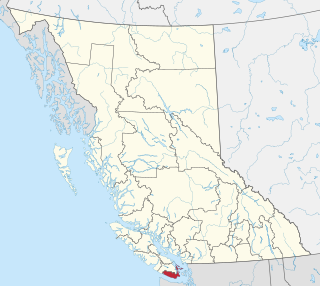
The Cowichan Valley Regional District is a regional district in the Canadian province of British Columbia that is on the southern part of Vancouver Island, bordered by the Nanaimo and Alberni-Clayoquot Regional Districts to the north and northwest, and by the Capital Regional District to the south and east. As of the 2021 Census, the Regional District had a population of 89,013. The regional district offices are in Duncan.

<span class="mw-page-title-main">Cariboo Regional District</span> Regional district in British Columbia, Canada

The Cariboo Regional District spans the Cities and Districts of Quesnel, Williams Lake, 100 Mile House, and Wells in the Central Interior of British Columbia.

<span class="mw-page-title-main">North Coast Regional District</span> Regional district in British Columbia, Canada

The North Coast Regional District is a quasi-municipal administrative area in British Columbia. It is located on British Columbia's west coast and includes Haida Gwaii, the largest of which are Graham Island and Moresby Island. Its administrative offices are in the City of Prince Rupert.

<span class="mw-page-title-main">Regional District of Mount Waddington</span> Regional district in British Columbia, Canada

The Regional District of Mount Waddington (RDMW) is a regional district in British Columbia. It takes in the lower Central Coast region centred on the Queen Charlotte Strait coast of northern Vancouver Island and the adjoining parts of mainland British Columbia. It has a total land area of 20,288.4 km2 and a 2016 census population of 11,035 persons, most of which is in towns on Vancouver Island and adjoining islands. The administrative centre is in the town of Port McNeill. Other municipalities include the district municipality of Port Hardy, the village of Port Alice, and the village of Alert Bay.

The demographics of Metro Vancouver indicate a multicultural and multiracial region. Metro Vancouver is a metropolitan area, with its major urban centre being Vancouver, British Columbia, Canada. The Vancouver census metropolitan area, as defined by Statistics Canada, encompasses roughly the same territory as the Metro Vancouver Regional District, a regional district in British Columbia. The regional district includes 23 local authorities. Figures provided here are for the Vancouver census metropolitan area and not for the City of Vancouver.

<span class="mw-page-title-main">Comox Valley Regional District</span> Regional district in British Columbia, Canada

The Comox Valley Regional District is a regional district in British Columbia, Canada. It was created on February 15, 2008, encompassing the southeastern portions of the former Regional District of Comox-Strathcona, and centred about the Comox Valley. The partition left the new Comox Valley Regional District with only 8.4 percent of the former Comox-Strathcona's land area, but 57.9 percent of its population. The CVRD covers an area of 2,425 square kilometres, of which 1,725 square kilometres is land, and serves a population of 72,445 according to the 2023 Census. The district borders the Strathcona Regional District to the northwest, the Alberni-Clayoquot Regional District to the southwest, and the Regional District of Nanaimo to the southeast, as well as the qathet Regional District along the Strait of Georgia to the east.

References

Notes

  1. Statistic includes all persons that did not make up part of a visible minority or an indigenous identity.
  2. Statistic includes total responses of "Chinese", "Korean", and "Japanese" under visible minority section on census.
  3. Statistic includes total responses of "Filipino" and "Southeast Asian" under visible minority section on census.
  4. Statistic includes total responses of "West Asian" and "Arab" under visible minority section on census.
  5. Statistic includes total responses of "Visible minority, n.i.e." and "Multiple visible minorities" under visible minority section on census.
  1. "Regional Board" . Retrieved July 9, 2019.
  2. "Regional District of Nanaimo". BC Geographical Names .
  3. "Population and dwelling counts: Canada and census divisions". Statistics Canada. February 9, 2022. Retrieved April 3, 2022.
  4. Government of Canada, Statistics Canada (October 26, 2022). "Census Profile, 2021 Census of Population". www12.statcan.gc.ca. Retrieved February 17, 2023.
  5. Government of Canada, Statistics Canada (October 27, 2021). "Census Profile, 2016 Census". www12.statcan.gc.ca. Retrieved February 17, 2023.
  6. Government of Canada, Statistics Canada (November 27, 2015). "NHS Profile". www12.statcan.gc.ca. Retrieved February 17, 2023.
  7. Government of Canada, Statistics Canada (August 20, 2019). "2006 Community Profiles". www12.statcan.gc.ca. Retrieved February 17, 2023.
  8. Government of Canada, Statistics Canada (July 2, 2019). "2001 Community Profiles". www12.statcan.gc.ca. Retrieved February 17, 2023.
  9. "2013-15 Board Strategic Plan" (PDF). Regional District of Nanaimo. October 4, 2012. Retrieved February 28, 2013.

49°15′00″N124°20′00″W / 49.25000°N 124.33333°W / 49.25000; -124.33333