Related Research Articles

The Okanagan, also called the Okanagan Valley and sometimes the Okanagan Country, is a region in the Canadian province of British Columbia defined by the basin of Okanagan Lake and the Canadian portion of the Okanagan River. It is part of the Okanagan Country, extending into the United States as Okanogan County in north-central Washington. According to the 2016 Canadian census, the region's population is 362,258. The largest populated cities are Kelowna, Penticton, Vernon, and West Kelowna.

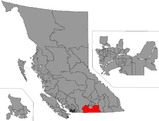
Osoyoos is the southernmost town in the Okanagan Valley in British Columbia between Penticton and Omak. The town is 3.6 km (2.2 mi) north of the United States border with Washington state and is adjacent to the Osoyoos Indian reserve. The origin of the name Osoyoos was the word sw̓iw̓s meaning "narrowing of the waters" in the local Okanagan language (Syilx'tsn). The "O-" prefix is not indigenous in origin and was attached by settler-promoters wanting to harmonize the name with other place names beginning with O in the Okanagan region. There is one local newspaper, the Osoyoos Times.

British Columbia Southern Interior was a federal electoral district in the province of British Columbia, Canada, that had been represented in the House of Commons of Canada from 1997 to 2015.
Yale–Cariboo was a federal electoral district in British Columbia, Canada, that was represented in the House of Commons of Canada from 1896 to 1917.
Boundary-Similkameen is a provincial riding formed in 2008. It includes the populations of Penticton-Okanagan Valley, West Kootenay-Boundary and Yale-Lillooet. The riding's name corresponds to that of a former riding in the same area, with similar but not identical boundaries.
Okanagan-Boundary was a provincial electoral district in the Canadian province of British Columbia spanning the area from the Similkameen towns of Kaleden and Keremeos to Grand Forks and Christina Lake, and including the southern Okanagan towns of Okanagan Falls, Oliver, Osoyoos, Rock Creek and Greenwood. The riding first appeared in the 1991 election as the result of a redistribution of the former riding of Boundary-Similkameen. The same area is now part of West Kootenay-Boundary.

Keremeos is a village in the Southern Interior of British Columbia, Canada. The name originated from the Similkameen dialect of the Okanagan language word "Keremeyeus" meaning "creek which cuts its way through the flats" referring to Keremeos Creek which flows down from the Upper Benchlands to the Similkameen River that flows past the village.

The British Columbia Interior, popularly referred to as the BC Interior or simply the Interior, is a geographic region of the Canadian province of British Columbia. While the exact boundaries are variously defined, the British Columbia Interior is generally defined to include the 14 regional districts that do not have coastline along the Pacific Ocean or Salish Sea, and are not part of the Lower Mainland. Other boundaries may exclude parts of or even entire regional districts, or expand the definition to include the regional districts of Fraser Valley, Squamish–Lillooet, and Kitimat–Stikine.
The Similkameen Country, also referred to as the Similkameen Valley or Similkameen District, but generally referred to simply as The Similkameen or more archaically, Similkameen, is a region roughly coinciding with the basin of the river of the same name in the Southern Interior of British Columbia. The term "Similkameen District" also refers to the Similkameen Mining District, a defunct government administrative district, which geographically encompasses the same area, and in more casual terms may also refer to the Similkameen electoral district, which was combined with the Grand Forks-Greenwood riding by the time of the 1966 election. The Similkameen Country has deep historical connections to the Boundary Country and the two are sometimes considered one region, partly as a result of the name of the electoral district. It is also sometimes classed as being part of the Okanagan region, which results from shared regional district and other administrative boundaries and names. The term "Similkameen District" may also historically refer to the Similkameen Division Yale Land District, which also includes Osoyoos and the Boundary Country to Osoyoos' east.
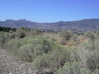
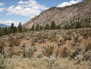
The Okanagan Desert is the common name for a semi-arid shrubland located in the southern region of the Okanagan Valley in British Columbia and Washington. It is centred around the city of Osoyoos and is the only semi-arid shrubland in Canada. Part of this ecosystem is referred to as the Nk'mip Desert by the Osoyoos Indian Band, though it is identical to the shrublands elsewhere in the region. To the northwest of this area lies an arid shrubland near Kamloops.
The New Westminster Land District is one of 59 land districts of British Columbia, Canada, which are the underlying cadastral divisions of that province, created with rest of those on Mainland British Columbia via the Lands Act of the Colony of British Columbia in 1860. The British Columbia government's BC Names system, a subdivision of GeoBC, defines a land district as "a territorial division with legally defined boundaries for administrative purposes". All land titles and surveys use the Land District system as the primary point of reference, and entries in BC Names for placenames and geographical objects are so listed.
The Cassiar Land District is a cadastral survey subdivision of the province of British Columbia, Canada, created with rest of those on Mainland British Columbia via the Lands Act of the Colony of British Columbia in 1860. The British Columbia government's BC Names system, a subdivision of GeoBC, defines a land district as "a territorial division with legally defined boundaries for administrative purposes". All land titles and surveys use the Land District system as the primary point of reference, and entries in BC Names for placenames and geographical objects are so listed.
The Comox Land District is one of the 59 land districts of British Columbia, Canada, which are part of the cadastral divisions of British Columbia, created with rest of those on Vancouver Island via the Lands Act of the Colony of Vancouver Island. The British Columbia government's BC Names system, a subdivision of GeoBC, defines a land district as "a territorial division with legally defined boundaries for administrative purposes". All land titles and surveys use the Land District system as the primary point of reference, and entries in BC Names for placenames and geographical objects are so listed.
The Lillooet Land District is one of the 59 cadastral subdivisions of British Columbia, which were created by the Lands Act of the Colony of British Columbia in 1859, defined as "a territorial division with legally defined boundaries for administrative purposes". The land district's boundaries came to be used as the boundary of the initial Lillooet riding for the provincial Legislature from 1871, when the colony became a province. In addition to use in descriptions of land titles and lot surveys, the Land District was also the basis of the Lillooet Mining District.
The Kootenay Land District is a cadastral survey subdivision of the province of British Columbia, Canada, created with rest of those on Mainland British Columbia via the Lands Act of the Colony of British Columbia in 1860. The British Columbia government's BC Names system, a subdivision of GeoBC, defines a land district as "a territorial division with legally defined boundaries for administrative purposes" All land titles and surveys use the Land District system as the primary point of reference, and entries in BC Names for placenames and geographical objects are so listed.
The Cariboo Land District is a cadastral survey subdivision of the province of British Columbia, Canada, created with rest of those on Mainland British Columbia via the Lands Act of the Colony of British Columbia in 1860. The British Columbia government's BC Names system, a subdivision of GeoBC, defines a land district as "a territorial division with legally defined boundaries for administrative purposes" All land titles and surveys use the Land District system as the primary point of reference, and entries in BC Names for placenames and geographical objects are so listed.
South Okanagan—Similkameen National Park Reserve is a proposed national park reserve located in the Regional District of Okanagan-Similkameen of British Columbia. The goal of the park is to work with the local First Nations to protect a large patch of Okanagan dry forests and part of the northern reach of the Columbia Plateau ecoregion in Canada.
The Clayoquot Land District is one of the 59 land districts of British Columbia, Canada, which are part of the cadastral divisions of British Columbia, created with rest of those on Vancouver Island via the Lands Act of the Colony of Vancouver Island. The British Columbia government's BC Names system, a subdivision of GeoBC, defines a land district as "a territorial division with legally defined boundaries for administrative purposes". All land titles and surveys use the Land District system as the primary point of reference, and entries in BC Names for placenames and geographical objects are so listed.
References
- ↑ "Osoyoos Division Yale Land District". Geographical Names Data Base . Natural Resources Canada . Retrieved September 27, 2013.
- ↑ "Osoyoos Division Yale Land District". BC Geographical Names . Retrieved September 27, 2013.
- ↑ BC Names/Geo BC entry "Cassiar Land District"
- ↑ British Columbia Online Cadastre Archived 2009-12-08 at the Wayback Machine To use this system to view Land District boundaries, pan or zoom to the approximate location, or use [Find Location tab] to pick a Land District by name. Open [Layers] tab along dark blue navigation bar, then open the Administrative Boundaries folder and select “Land Districts (outlined)”, also click “pointer” (will highlight turquoise). To substantially speed up refresh time, deselect Survey Parcels, cadastral fabric (etc) that might be part of the default suite; to remove the distracting map grid, open the Base Map folder and deselect "Grids". Whenever you make a change to the base, scroll to bottom of folders list and [Refresh Map] or select [Automatically Refresh Map]
| | This article about a location in British Columbia, Canada is a stub. You can help Wikipedia by expanding it. |