Related Research Articles

The Peace Arch is a monument situated near the westernmost point of the Canada–United States border in the contiguous United States, between the communities of Blaine, Washington and Surrey, British Columbia. Construction of the 20.5-metre (67 ft) tall arch was headed by American lawyer Sam Hill and dedicated in September 1921. The Peace Arch commemorates the signing of the Treaty of Ghent in 1814, and symbolizes a long history of peace between the two nations. The monument is built on the exact U.S.–Canada boundary, where Interstate 5 on the U.S. side of the border becomes Highway 99 on the Canadian side, in the grass median between the northbound and southbound lanes.

Cache Creek is a historic transportation junction and incorporated village 354 kilometres (220 mi) northeast of Vancouver in British Columbia, Canada. It is on the Trans-Canada Highway in the province of British Columbia at a junction with Highway 97. The same intersection and the town that grew around it was at the point on the Cariboo Wagon Road where a branch road, and previously only a trail, led east to Savona's Ferry on Kamloops Lake. This community is also the point at which a small stream, once known as Riviere de la Cache, joins the Bonaparte River.
Parksville is a city on Vancouver Island in British Columbia, Canada. The city lies along Highway 19A, 37 kilometres northwest of Nanaimo, 48 kilometres east of Port Alberni and 7 kilometres southeast of Qualicum Beach. The majority of Parksville's land base lies between Englishman River and French Creek, although a substantial portion of the city lies east of Englishman River, along the western shores of Craig Bay. As of the 2016 Census, Parksville's population was 12,514, representing a 4.5% increase over the 2011 Census.

Madeira Park is an unincorporated community in the area of Pender Harbour on the Sunshine Coast of southwest British Columbia, Canada. It was named for pioneer Joseph Gonsalos, a native of the Madeira Islands, who settled in the area in the early 1900s.

Peace Arch Park is an international park consisting of Peace Arch Historical State Park in the United States and Peace Arch Provincial Park in Canada. The park straddles the international boundary between the United States and Canada at the extreme western end of the main contiguous section of the two countries' land border, where it reaches Semiahmoo Bay of Puget Sound on the continent's Pacific Coast. The park's central feature is the Peace Arch.

Lasqueti Island is an island off the east coast of Vancouver Island in the Strait of Georgia, qathet Regional District, British Columbia, Canada and has a population of 399 people. A passenger-only ferry connects the island to the community of French Creek, near Parksville. The ferry makes two to three runs per day, five days per week, weather permitting.
Merville is an unincorporated community in the Comox Valley between the City of Courtenay, Mount Washington, Dove Creek, and Black Creek near the east coast of Vancouver Island. It was named by soldiers returning to the Island after fighting in France for Canada in World War I who named it after the place in France where the Canadians had their first field headquarters.

Vargas Island Provincial Park is a provincial park in British Columbia, Canada, comprising the west side of the island of the same name, which is located west of Meares Island and northwest of the resort community of Tofino in the Clayoquot Sound region of the West Coast of Vancouver Island, British Columbia, Canada. The park was created as part of the Clayoquot Land-Use Decision on July 13, 1995 and contains 5788 hectares, 1749 hectares of it being upland and 4039 hectares being foreshore. Also located on Vargas Island, on its north side, is Epper Passage Provincial Park.

Hardy Island Marine Provincial Park is a provincial park in British Columbia, Canada. Hardy and Nelson Island partially 'block' the mouth of Jervis Inlet and Hotham Sound to Malaspina Strait. Hardy Island is flatter in terrain and has the large Blind Bay within it. Blind Bay is an important anchorage for tugboats, tows and marine pleasure craft escaping the weather in Malaspina Strait.
Norbury Lake Provincial Park is a 97-hectare (240-acre) provincial park in British Columbia, Canada.
Honeymoon Bay is an unincorporated community in the Canadian province of British Columbia. It is located on Cowichan Lake in the southeastern part of Vancouver Island — approximately 75 kilometres (47 mi) northwest of Victoria — at 48°49′N124°10′W. In 2011, its population was listed at 580.
Errington is a small community on Vancouver Island, British Columbia, Canada, located on Errington Road, off Highway 4, just south of Parksville and Qualicum Beach.

Semiahmoo Bay is the southeastern section of Boundary Bay on the Pacific coast of North America. The bay is named for the Semiahmoo First Nation, who originally occupied the area. The Semiahmoo Peninsula borders the bay and was home to cannery operations. It is now home to the Semiahmoo Resort for golfing.
Monte Creek is a rural locality on the South Thompson River east of Kamloops, British Columbia, Canada, approximately equidistant from Kamloops and the village of Chase, British Columbia. It is mostly notable as a major highway junction where British Columbia Highway 97 branches off from the Trans-Canada Highway south towards the Okanagan via Falkland and Westwold. Monte Lake, a recreational community on the shores of the lake of the same name, is a few miles south of the junction.
Silverdale is a semi-rural neighbourhood of the District of Mission, British Columbia, Canada c. 40 km east of Vancouver on the east bank of the Stave River at its confluence with the Fraser. Noted for its historic Italian Canadian community, its economy was farming, fishing and logging based until the general suburbanization of Fraser Valley life in the 1960s and '70s. Of its Italian community, notable offspring include Phil Gaglardi, former BC Highways minister, and speed-skater Eden Donatelli. Silverdale is also notable as the site of Canada's first train robbery, by the "Gentleman Bandit" Billy Miner, and it is there he is supposed to have first used the polite "Hands Up!" in the course of the robbery.

The Ashnola River is a tributary of the Similkameen River, rising in the northeastern part of the North Cascades in Washington, United States, and flowing north into British Columbia, Canada, to join the Similkameen River about halfway along that river's course between the towns of Princeton and Keremeos. The river crosses the international boundary at 49°00′00″N120°19′37″W and transits Cathedral Provincial Park. It has one main tributary, Ewart Creek, which is about 25 kilometres (16 mi) long and begins virtually at the border and is entirely within Cathedral Park.
The Semiahmoo Indian Reserve is a 129.1-hectare Indian Reserve in the Lower Mainland, British Columbia, located on Semiahmoo Bay between the City of White Rock and Peace Arch Park, which sits astride the international boundary with Washington state.
Webster's Corners is a community in British Columbia, located northeast of Albion in Maple Ridge, British Columbia. Webster's Corners was founded by James Murray Webster who was born in Aberdeen, Scotland. James Webster arrived in 1883 and was the first postmaster. He named the settlement after himself.

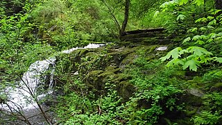
Cascade Falls Regional Park is a regional park under the administration of the Fraser Valley Regional District in the Lower Mainland region of British Columbia, Canada. The park was originally 9.5 hectares in area but was expanded to a current 22 hectares. It has picnic tables and pit toilets, with various hiking trails and a walkway leading to a viewing platform over a large waterfall 30m in vertical drop, which is 15 minutes from the park's parking lot. It is located in the McConnell Creek area northeast of Mission, which gets its name from the former name of Cascade Creek, McConnell Creek, which was named for a logger in the area called Jack McConnell. Cascade Creek's outfall is into the southeast end of Stave Lake near Davis Lake Provincial Park.
0 Avenue is a road in British Columbia straddling the Canada–United States border, stretching from Surrey to Abbotsford. The road runs parallel for many miles and is very close to the physical border between Canada and the United States.
References
- ↑ Akrigg, G.P.V.; Akrigg, Helen B. (1986), British Columbia Place Names (3rd, 1997 ed.), Vancouver: UBC Press, ISBN 0-7748-0636-2
"Douglas (community)". BC Geographical Names.
Coordinates: 49°00′10″N122°44′08″W / 49.00278°N 122.73556°W
| This article about a location on the Coast of British Columbia, Canada is a stub. You can help Wikipedia by expanding it. |