
Peachland is a district municipality in the Okanagan Valley on the west side of Okanagan Lake in British Columbia, Canada. It was founded in 1899 by John Moore Robinson, although the region had long been home to the Okanagan people. Peachland is approximately half-an-hour's drive south of the city of Kelowna and about a 20-minute drive north of Summerland. The Okanagan Valley is very narrow in the area and there are few terraces that mark former lake levels and the former lake bottom. As a result, the city is largely located on a steep sidehill. Like many other areas in the Okanagan, Peachland is rapidly growing, with new residents coming from all across Canada. Across the lake from Peachland is Rattlesnake Island, home of the legendary Ogopogo. Peachland is approximately 370 km from Vancouver, British Columbia, on the British Columbia south coast.
The Skatin First Nations, aka the Skatin Nations, are a band government of the In-SHUCK-ch Nation, a small group of the larger St'at'imc people who are also referred to as Lower Stl'atl'imx. The Town of Skatin - the St'at'imcets version of the Chinook Jargon Skookumchuck- is located 4 km south of T'sek Hot Spring- alt. spelling T'sek Hot Spring - commonly & formerly named both St. Agnes' Well & Skookumchuck Hot Springs The community is 28 km south of the outlet of Lillooet Lake on the east side of the Lillooet River. It is approximately 75 km south of the town of Pemberton and the large reserve of the Lil'wat branch of the St'at'imc at Mount Currie. Other bands nearby are Samahquam at Baptiste Smith IR on the west side of the Lillooet River at 30 km. and Xa'xtsa First Nations; the latter is located at Port Douglas, near the mouth of the Lillooet River where it enters the head of Harrison Lake. The N'Quatqua First Nation on Anderson Lake, between Mount Currie and Lillooet, was at one time involved in joint treaty negotiations with the In-SHUCK-ch but its members have voted to withdraw, though a tribal council including the In-SHUCK-ch bands and N'Quatqua remains, the Lower Stl'atl'imx Tribal Council.

Adams Lake Provincial Park is a provincial park in British Columbia, Canada. It encompasses three distinct parks: Adams Lake Provincial Park, Adams Lake Marine Provincial Park, and Adams Lake Marine Provincial Park.
Boundary Creek Provincial Park is a provincial park in British Columbia, Canada located south of Greenwood BC in that province's Boundary Country, adjacent to BC Highway 3. The eponymous Boundary Creek flows through the park.
Conkle Lake Provincial Park is a provincial park in British Columbia, Canada, located west of the confluence of the Kettle and West Kettle Rivers. The park size is 587 hectares.

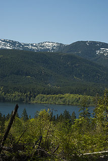
Darke Lake Provincial Park is a provincial park in British Columbia, Canada located west of Okanagan Lake, southwest of the town of Peachland in that province's Okanagan region. The park is approximately 1,470 hectares in size and was established in 1968 as a provincial park Darke Lake, also mapped historically as Fish Lake, is northwest of Summerland and is named after Silas Robert Darke, an early settler in the 1890s. In 1941 Howard Clark bought Fish Lake from Clyde Stewart. He was a hunting and fishing guide that ran the camp, as well as raised four children with his wife Hazel. The children were Betty, Roger, Dale & Audrey. In 1959 he sold it to Jake and Betty Enns.
Fossli Provincial Park is a provincial park in British Columbia, Canada, located on Stirling Arm of Sproat Lake on Vancouver Island. The 52-hectare park, west of Port Alberni, is accessible by water or private logging road. It has few services, but has a 30-minute hiking trail to an old homestead site. The homestead belonged to Helen and Armour Ford, who donated the land for the park to the province in 1974. Saint Andrew's Creek runs through the park, and is a fall spawning ground for coho salmon.
Harbour Dudgeon Lakes Provincial Park is a provincial park in British Columbia, Canada, located west of the Adams River, northwest of Celista Mountain. It was established on April 30, 1996. The park is located approximately 175 km northeast of Kamloops.
Johnstone Creek Provincial Park is a provincial park in British Columbia, Canada, located west of the confluence of Rock Creek and the Kettle River and the town of Rock Creek. The park has a roughly 38 hectare area, and is near to the Crowsnest Highway.
Monte Lake Provincial Park is a provincial park in British Columbia, Canada, located on the east side of Monte Lake and to the south of the community of Monte Lake, British Columbia which is at the north end of the lake. About five hectares in size, it protects an area of Ponderosa pine and grasslands.
Upper Violet Creek Provincial Park is a provincial park in British Columbia, Canada.
Pennask Lake Provincial Park is a provincial park in British Columbia, Canada, located on the easternmost heights of the Thompson Plateau,50 km (31 mi) to the northwest of the Okanagan town of Peachland.
Puntchesakut Lake Provincial Park is a provincial park in British Columbia, Canada. It is approximately 16.7m deep and has trout as the main fish source.

Shuswap Lake Provincial Park is a provincial park in British Columbia, Canada.
Taylor Arm Provincial Park is a provincial park in British Columbia, Canada, located on the north side of Sproat Lake 23 km northwest of Port Alberni on Vancouver Island. Situated along Highway 4, the 71-hectare park has few services but provides group camping sites, undeveloped beaches, and day-use areas. The group camping site has pit toilets and a hand pump water supply, and is connected to the lake shore via a trail that passes under the highway.
There are several lakes named Mud Lake within the Canadian province of Alberta.
The Lower Similkameen Indian Band or Lower Smelqmix, is a First Nations band government in the Canadian province of British Columbia. Their office is located in the village of Keremeos in the Similkameen region. They are a member of the Okanagan Nation Alliance.
The Nation Lakes are a series of four lakes in the Nation River system of the Omineca Country of the Central Interior of British Columbia, Canada. The four lakes are, from west to east (downstream), Tsayta, Indata, Tchentlo, and Chuchi Lakes. Nation Lakes Park was established in 2004 as a result of the Fort St. James Land Resource Management Plan and is a popular canoeing destination.
The Cascade Recreation Area was a Provincial Recreation Area in the Hozameen Range of the Cascade Mountains of British Columbia, Canada, located north of and was added to E.C. Manning Provincial Parkin 2010. It is roughly 11,858 ha. and was created on March 14, 1987. The recreation area has limited road access and is used by hikers, horse riders, mountain bikers and, in winter, snowmobilers. The nearest towns are Hope and Princeton.
The Scowlitz First Nation or Scowlitz Indian Band is the band government of Skaulits subgroup of the Stó:lō people located on Harrison Bay in the Upper Fraser Valley region between Chehalis (E) and Lake Errock, British Columbia, Canada (W). They are a member government of the Stó:lō Tribal Council.
